
 Open Access Article
 This Open Access Article is licensed under a
 Creative Commons Attribution 3.0 Unported Licence
Integrated air quality information for Kampala: analysis of PM2.5, emission sources, modelled contributions, and institutional framework†
Deo
Okure
*a,
Sarath K.
Guttikunda
 *bc,
Richard
Sserunjogi
a,
Priscilla
Adong
a,
Sai Krishna
Dammalapati
c,
Dorothy
Lsoto
d,
Paul
Green
a,
Engineer
Bainomugisha
a and
Jian
Xie
e
*bc,
Richard
Sserunjogi
a,
Priscilla
Adong
a,
Sai Krishna
Dammalapati
c,
Dorothy
Lsoto
d,
Paul
Green
a,
Engineer
Bainomugisha
a and
Jian
Xie
e
aAirQo, Department of Computer Science, Makerere University, Street: 56 University Pool Road, Kampala, Uganda. E-mail: dokure@airqo.net
bTRIP-Centre, Indian Institute of Technology, New Delhi, India. E-mail: sguttikunda@gmail.com
cUrban Emissions Information, Goa, India
dEnvironment and Resources at the Nelson Institute for Environmental Studies, The University of Wisconsin–Madison, USA
eThe World Bank, Washington, DC, USA
First published on 27th February 2025
Abstract
Kampala, the political and economic capital of Uganda and one of the fastest urbanizing cities in sub-Saharan Africa, is experiencing a deteriorating trend in air quality. This decline is driven by emissions from multiple diffuse local sources, including transportation, domestic and outdoor cooking, and industries, as well as by sources outside the city airshed, such as seasonal open fires in the region. PM2.5 (particulate matter under 2.5 μm size) is the key pollutant of concern in the city with monthly spatial heterogeneity of 60–100 μg m−3. Outdoor air pollution is distinctly pronounced in the global south cities and lack the necessary capacity and resources to develop integrated air quality management programs including ambient monitoring, emissions and pollution analysis, source apportionment, and preparation of clean air action plans. This paper presents the first comprehensive integrated assessment of air quality in Kampala to define a multi-level intervention framework, utilizing ground measurements from a hybrid network of stations, global reanalysis fields from GEOS-Chem and CAMS simulations, a high-resolution (∼1 km) multi-pollutant emissions inventory for the designated airshed, WRF-CAMx-based PM2.5 pollution analysis, and a qualitative review of the institutional and policy environment in Kampala. This collation of information documents baseline data for all known sectors, providing a foundational resource for the development of a clean air action plan. The proposed plan aims for better air quality in the region using a combination of short-, medium-, and long-term emission control measures for all the dominate sources and institutionalize pollution tracking mechanisms (like emissions and pollution monitoring and reporting) for effective management of air pollution.
Environmental significanceTo the best of our knowledge, this is the first assessment that provides a holistic overview of air quality in Kampala, leveraging different data types coupled with a review of institutional mechanisms. Highlights of this study are: (a) an integrated evaluation of monitoring and modelling data for air quality management in Kampala (b) a high-resolution (0.01°) multi-pollutant emissions inventory for the Kampala airshed (c) modelled source apportionment for PM2.5 pollution accounting for sources inside and outside the Kampala airshed and (d) a three-layered intervention framework and the stakeholder landscape for clean air action in Kampala. |
1 Introduction
Air pollution is a major health risk factor contributing to an estimated 7 million premature deaths annually, in addition to the cost of socio-economic burdens of the communities.1–6 The mortality and morbidity impacts are distinctly pronounced in urban centres of low- and middle-income countries (LMICs) of the global South and yet effective management programs are not fully established.7,8 Between 1990 and 2021, estimated annual premature deaths in the Sub-Saharan Africa (SSA) due to outdoor PM2.5 exposure levels increased from 130![[thin space (1/6-em)]](https://www.rsc.org/images/entities/char_2009.gif) 000 to 209000 and due to household (indoor) air pollution (HAP) exposure levels increased from 685000 to 740000.2 The lower rate of increase in HAP estimates is primarily due to promotion of clean fuels and clean cookstoves in the urban and semi-urban areas. Together in SSA outdoor and indoor air pollution is responsible for one million premature deaths annually. Between 1970 and 2018, deteriorating air quality is linked to a reduction of 60%, 56%, and 34% of urban visibility in Nairobi, Kampala, and Addis Ababa respectively.9 The socio-economic cost of air pollution in Africa is estimated to be higher than malnutrition and unsafe sanitation10 and SSA continues to experience increasing amounts of poor air quality from biomass burning for cooking and heating, lack of clean and efficient public transport systems to support growing mobility needs, inefficient combustion of fossil fuels at various industries, increasing informal settlements, and shortfalls in urban planning to address the growing demands.6,11–16
000 to 209000 and due to household (indoor) air pollution (HAP) exposure levels increased from 685000 to 740000.2 The lower rate of increase in HAP estimates is primarily due to promotion of clean fuels and clean cookstoves in the urban and semi-urban areas. Together in SSA outdoor and indoor air pollution is responsible for one million premature deaths annually. Between 1970 and 2018, deteriorating air quality is linked to a reduction of 60%, 56%, and 34% of urban visibility in Nairobi, Kampala, and Addis Ababa respectively.9 The socio-economic cost of air pollution in Africa is estimated to be higher than malnutrition and unsafe sanitation10 and SSA continues to experience increasing amounts of poor air quality from biomass burning for cooking and heating, lack of clean and efficient public transport systems to support growing mobility needs, inefficient combustion of fossil fuels at various industries, increasing informal settlements, and shortfalls in urban planning to address the growing demands.6,11–16
In Kampala, diffused sources like cookstoves, vehicle exhaust, road dust, and waste burning, are the major challenge.12,17–20 While Uganda (and Kampala as a city) have registered key milestones for AQM since 1990, large gaps in air quality data and institutional capacity have been a major barrier in achieving clean air targets. Some scoping studies9,17 and ongoing measurement campaigns19–22 have provided insights, but the prohibitive costs of traditional air quality monitoring has limited the availability of data for tracking progress and lack there-off.7,8,19
In this paper, we present an integrated overview of the state of air quality in Kampala, including a review of available monitoring data, an analysis of long-term PM2.5 pollution trends from satellite retrievals and reanalysis fields, emissions and pollution analysis using the best available information, and an examination of current initiatives and challenges in various sectors towards effective AQM in the city. To the best of our knowledge, this is the first assessment that provides a holistic overview of air quality in Kampala while leveraging different data types coupled with a review of institutional mechanisms.
2 Data resources and models
For the Greater Kampala Metropolitan area, various open resources were utilized to establish the baseline information necessary for developing an operational emissions inventory and to support subsequent chemical transport modeling aimed at evaluating ambient PM2.5 concentrations. This includes land use and land cover databases, global human settlement databases, road networks, commercial activities databases, building density information, population density information, satellite observations of columnar pollutant concentrations, and global reanalysis fields.23 City-specific information was obtained from the statistics department archives.24–26 The area covering the airshed at 1 km resolution was scanned using the Google Earth platform imagery to locate and digitize rock quarries, industrial estates, water bodies, and other points of interests. Additional database details are included in the Data section, and all extracted data are provided in the ESI.†2.1 Designated airshed
Kampala is the economic and political capital of Uganda with a resident population of 1.5 million and a population density more than 40 times the national average. The Greater Kampala Metropolitan area is home to 4.5 million people.26 There are 10 other cities in Uganda with population more than 100000 inhabitants (like Kira, Jinja, Mbarara and Masaka) resulting in 25% urbanization. Kampala is divided into 5 urban administrative divisions – Central, Nakawa, Makindye, Lubaga, and Kawempe.
For the purposes of data extractions and trend analysis, we defined Kampala's airshed covering the main city administrative boundary and extending to surrounding rural areas between 32.3°E to 32.9°E in longitude and 0°N to 0.6°N in latitudes (Fig. 1a). The domain is further disaggregated into 0.01° (approximately 1 km) grids to support statistical analysis of emissions and pollution information. A detailed file with grid information in KML format is included in the ESI.† The capital city has expanded significantly from 1990 to date, unceasingly transforming adjoining rural landscapes into urban land uses (Fig. 1b). This contributed to the spike in the daytime transient population of over 2.5 million, coming from the workforce settlements in neighboring municipalities. The built-up area estimated by ESA's global human settlements (GHS) program increased 3 times from 137 km2 to 438 km2 between 1975 and 2014.27
 | ||
| Fig. 1 (a) Extent of the Greater Kampala airshed covering the main city province and the neighborhood with potential to directly influence the urban air quality and the AirQo sensor network (b) urban built-up area for 1990 and 2014 from ESA's GHS program (c) road network layers as primary, secondary, and all roads from the OpenStreetMaps database (d and e) gridded population density for years 2000 and 2019, available at 0.01° spatial resolution from LANDSCAN program. | ||
Also extracted from https://www.openstreetmap.org/, Kampala's airshed includes 1000 hospitals, 400 hotels, 400 fuel stations, 5100 traffic points (including bus stops, train stops, traffic junctions, and parking lots), 450 workshop points, 5500 commercial points (including banks, malls, museums, all shops, and food joints), 450 telecommunication towers, 750 industrial points, and more than 80000 other points of interests like buildings. All these points of interest are hotspots for energy consumption, fugitive emissions, and pollution exposure. Likewise, airsheds road network includes 1300 km of primary roads (including highways), 13000 km of arterial and tertiary roads, and 21000 of total roads (including unpaved and unclassified roads) (Fig. 1c). Annual gridded population data between 2000 and 2022 is obtained from Oakridge National Labs LANDSCAN program28 (Fig. 1d and e). Gridded population data for the Greater Kampala region for all years between 2000 and 2022 is included in the ESI.†
2.2 Airshed meteorology
The meteorological data is modelled using the Weather Research Forecasting (WRF) model (https://www.mmm.ucar.edu/models/wrf) in a nested formatted from SSA to Uganda to Greater Kampala region. For the defined airshed, model-ready netCDF files are available upon request (via email) and a summary is included in the ESI.†Kampala has a tropical savanna climate with two distinct seasons – the dry season and the rainy season. The WRF model outputs presented in Fig. 2 have a final spatial resolution of 0.01° and temporal resolution of 1-hour. The dry season from December to February is generally sunny with clear skies and low humidity. The rainy season from March to May and again from September to November brings heavy rainfall. June to August is a transitional period between the two seasons and the weather can be variable. The temperature remains in the range of 20–25 °C and sometimes it can rain, but it is not as consistent as in the rainy season. The predominant wind direction is Southerly for most of the year and a substantial portion is Northerly for the months of Dec–Jan–Feb. Any sources outside the city airshed in these directions have the highest potential to contribute to the city's air quality via long-range transport. Overall, Kampala has a relatively stable climate with daytime temperatures of 30 °C and nighttime temperatures of 20 °C and some unpredictable weather only during the rainy season.
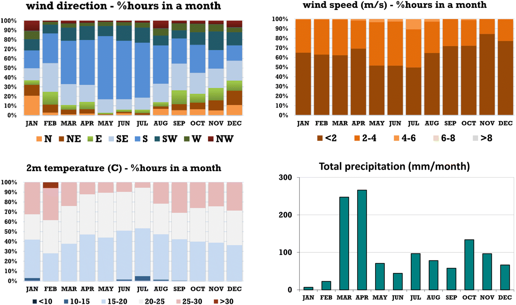 | ||
| Fig. 2 Summary of meteorological parameters by month for the Greater Kampala region, extracted from WRF simulations using NCEP reanalysis fields. | ||
2.3 Ambient PM2.5 measurements
The ambient monitoring data is collected from two networks. The reference-grade station network consists of two operational units in the city: one managed by the US Embassy in Kampala and the other operated by the AirQo team at Makerere University. The second network comprises 85 low-cost sensors operated by AirQo (Fig. 1a).19,21,29,30 These units feature dual PMS 5003 sensors and are designed to run on direct electricity, battery, and solar power, in areas with unreliable power supply. They are built to withstand harsh environmental and physical conditions, including dust and humidity, and to store long-term data to avoid internet connectivity issues (common in SSA). The AirQo sensor network is also operational in other African cities – Accra, Dakar, Douala, Kisumu, Lagos, and Nairobi.US EPA's AirNow International program operates one reference-grade Beta Attenuation Monitor (BAM) to measure and report PM2.5 concentrations from the US Embassy compound in Kampala. Since 2017, this station data openly reported PM2.5 concentrations data and air quality index (AQI) as a health alert indicator (https://www.airnow.gov/). A summary of the data collected for the years 2017 to 2024 is presented in Table 1. The annual averages fluctuate between 50 and 60 μg m−3, which is 10 to 12 times the World Health Organization (WHO) guideline of 5 μg m−3, with seasonal highs reaching 100 μg m−3. The drop in the annual average in 2023 is because of 50–60% drops in the months of Oct–Nov. This is directly linked to more than normal rains in 2023 (a copy of the monthly precipitation rates extracted from the global repository https://psl.noaa.gov/data/atmoswrit/timeseries is included in the ESI†). For comparison, monthly averages from another reference site at Makerere University operated by AirQo are shown in Table 2. The location represents an urban background with limited influence of transport emissions and presents a contrast from the US Embassy.
| Year | Jan | Feb | Mar | Apr | May | Jun | Jul | Aug | Sep | Oct | Nov | Dec | Annual |
|---|---|---|---|---|---|---|---|---|---|---|---|---|---|
| 2017 | 45.2 | 39.1 | 34.9 | 34.1 | 57.4 | 66.6 | 60.5 | 58.6 | 52.5 | 66.3 | 69.7 | 53.7 ± 31.5 | |
| 2018 | 91.0 | 65.0 | 52.2 | 40.7 | 40.8 | 50.6 | 61.9 | 68.0 | 62.9 | 57.0 | 55.1 | 60.9 | 59.1 ± 33.5 |
| 2019 | 61.6 | 61.9 | 53.9 | 42.9 | 41.8 | 72.8 | 77.5 | 69.2 | 65.5 | 48.9 | 56.7 | 72.4 | 60.5 ± 33.0 |
| 2020 | 85.1 | 67.0 | 52.7 | 34.7 | 38.3 | 55.5 | 71.6 | 65.6 | 58.2 | 53.0 | 46.9 | 57.7 ± 30.7 | |
| 2021 | 59.9 | 88.3 | 50.4 | 38.8 | 47.7 | 50.9 | 59.0 | 59.4 | 49.9 | 50.6 | 55.1 | 52.0 | 54.5 ± 30.3 |
| 2022 | 69.9 | 57.5 | 52.5 | 37.9 | 41.0 | 42.6 | 49.9 | 48.8 | 50.2 | 51.2 | 47.3 | 56.5 | 50.6 ± 26.8 |
| 2023 | 58.5 | 59.6 | 41.9 | 31.3 | 37.4 | 37.6 | 53.3 | 47.1 | 39.8 | 29.5 | 22.8 | 56.8 | 43.6 ± 26.7 |
| 2024 | 68.2 | 39.4 | 23.6 | 16.3 | 20.9 | 40.6 | 49.0 | 43.5 | 66.6 | 96.0 | 87.0 | 50.0 ± 44.2 |
| Year | Jan | Feb | Mar | Apr | May | Jun | Jul | Aug | Sep | Oct | Nov | Dec | Annual |
|---|---|---|---|---|---|---|---|---|---|---|---|---|---|
| 2020 | 46.0 | 40.9 | 35.6 | 31.2 | 32.1 | 39.5 | 36.1 ± 23.4 | ||||||
| 2021 | 38.5 | 58.5 | 27.4 | 15.5 | 52.2 | 36.4 | 31.5 | 31.5 | 35.0 | 31.7 | 38.7 ± 26.9 | ||
| 2022 | 50.8 | 43.3 | 39.2 | 22.8 | 16.2 | 33.6 | 34.0 | 35.8 | 33.0 | 30.7 | 32.0 | 36.0 ± 23.9 | |
| 2023 | 49.8 | 28.7 | 19.0 | 48.1 | 35.8 | 27.7 | 25.6 | 32.6 ± 24.8 | |||||
| 2024 | 69.4 | 41.3 | 25.1 | 14.0 | 26.6 | 37.0 | 48.5 | 40.5 | 38.6 | 33.8 | 39.5 ± 25.7 |
While BAM is a regulatory-grade ambient monitor, two stations are not a mathematically representative sample size for any city.31 Kampala's air quality monitoring needs are supplemented by a network of 85 low-cost sensors. The AirQo sensors were collocated and routinely calibrated against the two reference monitors.21 Initial sensor measurements overestimated PM concentrations linked to variation in the atmospheric humidity levels, which is a controlled parameter in a BAM using an in-built dryer. The sensor data was further calibrated using random forest and lasso regressions for PM2.5 and PM10, respectively, for relative humidity and temperature. The random forest model performed optimally decreasing RMSE from 18.6 to 7.2 μg m−3 for PM2.5 and from 13.4 to 7.9 μg m−3 for PM10 concentrations.
A summary of PM2.5 concentrations measured using the low-cost sensor network in Kampala is shown in Fig. 3. The variation in the concentrations every month is between the averages at the stations across the airshed. Kampala's seasonal air quality pattern coincides with its weather pattern – lows during two rainfall seasons from March to May (MAM) and September to November (SON) (Fig. 2) and highs during the two dry seasons from December to February (DJF) and June to August (JJA) which allows for accumulation of the aerosols.9,32,33 All the months experience spatial heterogeneity of 40–80 μg m−3, with some stations recording 100–120 μg m−3 during the peak season. This is an indication of diffused sources and their intensities across the airshed. The diurnal pattern in the sensor data highlights typical hourly activities, displaying two distinct peaks. The first peak occurs between 7 AM and 10 AM, coinciding with morning cooking and the rush hour cycle. The second peak begins around 5 PM and reaches its maximum around 9 PM, corresponding to evening cooking and the rush hour cycle. Nighttime highs are sustained by lower mixing heights and nighttime freight vehicle movement.
 | ||
| Fig. 3 Summary of calibrated PM2.5 concentrations from the AirQo monitoring network, including the range in monthly and hourly concentrations. | ||
2.4 Global reanalysis data
Global chemical transport model simulations provide a combined snapshot of anthropogenic emissions, natural emissions, and long-range regional transport of pollution. However, because of their coarse grid resolution, these results must be considered as indicative of regional trends and not as absolute representation. For regions with limited or no monitoring data, these results provide a benchmark at a coarse level.34The reanalysis data for the Greater Kampala region is extracted from two systems – (a) Copernicus Atmospheric Monitoring System (CAMS – https://ads.atmosphere.copernicus.eu/) for the period for 2003–2022 has the following monthly average fields – particulate fractions PM2.5 and PM10 and for gaseous pollutants, sulfur dioxide (SO2), nitrogen dioxide (NO2), carbon monoxide (CO), and ozone (O3). This data is only available at grid resolution of 0.75°. CAMS considers, in its emission inventories, yearly improvements or lack thereof in various sectors, and includes nudging with satellite feeds and ground measurements. Data for Kampala is extracted from the grid covering the city airshed (b) Global Burden of Disease – Mapping of Air Pollution Sources (GBD-MAPS – https://sites.wustl.edu/acag/datasets/gbd-maps) is an open-access database distributed by the Washington University in St. Louis, USA.15,35 GBD-MAPS system combined ground-level PM2.5 concentrations and AOD from multiple satellite retrievals, with GEOS-Chem global chemical transport model results to establish source contributions to ambient PM2.5 pollution.
Year-on-year changes in concentrations modeled in the CAMS reanalysis system, clubbed into three time periods (2003–09, 2010–19, and 2020–22) points to a deteriorating trend over the Greater Kampala region (Table 3). Graphical comparison is included in a presentation in the ESI.† There is a 10% increase in the average and minimum pollutant concentrations, which can lead to an overall increase in the exposure rates and health impacts related to ambient PM2.5 and ozone concentrations. These specific time periods were selected to make it a decadal comparison. The same exercise using specific years or different time periods will result in a different conclusion.
| Year | PM2.5 | NO2 | SO2 | Ozone |
|---|---|---|---|---|
| 2003–09 | 37.3 (25.6–69.2) | 7.3 (5.5–13.6) | 3.0 (2.3–5.0) | 66.6 (46.9–91.2) |
| 2010–19 | 39.8 (26.6–66.0) | 8.3 (6.6–13.3) | 3.4 (2.6–4.8) | 68.6 (39.8–120.7) |
| 2020–22 | 40.4 (28.8–62.5) | 8.2 (6.1–9.4) | 3.5 (3.0–4.3) | 73.3 (57.2–92.7) |
The CAMS reanalysis monthly PM2.5 values range between 25 and 70 μg m−3. The overall trend in the monthly average concentrations is qualitatively like the trend in Fig. 3, but quantitatively lower. The lower values are expected in the global model due to averaging of all the urban emissions over a large grid, whereas the ambient measurements represent the pollution sources in the immediate vicinity and tend to show higher values.
PM10 concentrations were on average 30% higher than PM2.5, reflecting the presence of resuspended dust and wind-blown dust (storms) in the region. Low SO2 concentrations (averaging under 5 μg m−3) reflect the use of low-sulfur fuels and limited industrial activities depending on fossil fuels like coal. Low NO2 concentrations (averaging under 10 μg m−3) reflect smaller vehicle density on the roads. However, daytime NO2 concentrations above 50 μg m−3 is a concern and reflect the growing number of vehicles on the road and regional long-range contributions.17 Ozone is also an important health impacts contributor (along with PM2.5) in the GBD assessments.2
According to the GBD-MAPS assessments, a majority of PM2.5 pollution in Kampala is sourced to fossil fuel (coal, petrol, diesel, gas, biomass, and waste) combustion that supports daily activities in the fields of personal transport, freight transportation, electricity generation, industrial manufacturing, cooking, heating, construction, road dust resuspension, and waste burning. At 38%, residential and commercial cooking is the largest source, followed by all-dust (21%), industries including power generation (11%), road transport (5%), open biomass burning (14%), and others (9%). Schwander et al., 2014,33 conducted spot measurements in Mpererwe district and analyzed PM2.5 filters for mass and chemical species for 2 days in December and January 2013. While this is not a representative sample, the chemical analysis revealed the nature of the mix of pollution in the city is like the global model results. Of the total measured PM2.5 mass (above 100 μg m−3), 41–59% was crustal species and 33–55% was carbonaceous aerosol, indicating sources such as diesel combustion for black carbon, biomass burning for organic carbon, long-range transport for the secondary organic aerosols, vehicles for road-dust resuspension, and construction activities.
2.5 Urban and regional emission sources
In SSA, Uganda has the lowest share of population with access to clean energy for cooking and lighting.25,36 Total access to electricity is about 28%, averaging 40% in the urban areas and very low in the rural areas. According to the Uganda Electricity Regulatory Authority, electricity demand in Kampala has been growing at an average rate of 10–15% per year. There is a very low uptake of stand-alone modern energy systems in the form of Liquefied Petroleum Gas (LPG), solar, biogas and improved cookstoves, which is largely driven by the economics of the energy sector. Consequently, more than 90% of the residential energy demand is met by emission-intensive solid biomass in the form charcoal and firewood.25,26,37 Annual demand for biomass is approximately 53 million tons. Charcoal is the dominant fuel in the urban areas and firewood and agricultural residues in the rural areas.Kampala's daily waste generation rate is approximately 1400 tons per day. Kitezi landfill is located on the outskirts of the city (Fig. 4a) with an operational area of 0.15 km2, managing less than 60% of the all the solid waste generated within the city limits. The landfill faces many challenges, including limited capacity, poor management, and a lack of proper planning and maintenance, which has led to environmental degradation and negative impacts on local communities. A large portion of the uncollected waste from informal settlements is openly burnt.
 | ||
| Fig. 4 (a) Kitezi landfill (b) cement factory and (c) rock quarries spread across the airshed (snapshots from Google Earth) and (d) a map of fires detected by VIIRS satellite in January over Uganda and its surroundings (https://firms.modaps.eosdis.nasa.gov/). | ||
The Greater Kampala region (Fig. 1) hosts 32% of large- and small-scale manufacturing businesses, contributing to more than one-third of annual GDP, including a range of products, like textiles, food and beverages, pharmaceuticals, and construction materials. The city's industrial sector is expected to continue to grow as the demand for goods and services is expected to increase.24,26,38,39 Significant pollution from untreated effluents (solids, liquids, and gases) arises from these energy-intensive industrial processes. Overall, while 80% of the energy demand in Uganda is in the residential and commercial sectors, 65% of the electricity demand is in the industrial sector. For example, the cement factory to the East of the city has an annual manufacturing capacity of one million tons and is one of the largest consumers of coal (Fig. 4b). Other notable industries in the airshed are 50 MW Kiwanga power plant operating on heavy fuel oil. Many industries were set-up before the development of critical national environment laws which could have impacted on the decision to conduct environmental and social impact assessment studies.24,40
Kampala's vehicle fleet mix is unique compared to the other capital cities like Delhi and Beijing, comprising of a mix of old and new vehicles, including 46% 14-seater commercial buses (referred to as taxis), 32% motorcycle taxis (referred to as boda–boda), 19% private cars, and other freight vehicles (2%), with an estimated annual increase of 11% in total registrations.26,41,42 In recent years, largest increase in the fleet size is from the motorcycles – boda–boda's have become an important part of the city's transportation system, due to their speed and ease of maneuverability in the congested streets, providing a quick and affordable mode of transportation for people and goods. However, this has also led to increased traffic congestion and safety concerns, such as accidents and road crashes. The unofficial boda–boda fleet size is 200000. The second-hand car market in Uganda is a significant part of the country's automobile industry and it offers a wide range of used vehicles, including cars, vans, and trucks, from Japan, the United Kingdom, the US, and Europe. In addition to these countries, some second-hand vehicles are also imported from neighboring Kenya and Tanzania. These vehicles may not be of the same quality but are more affordable in Uganda. Overall, Kampala experiences congestion effects arising from the limited mass transit alternatives coupled with poor road infrastructure, which leads to higher emissions and exposure rates on the roads. The sulfur content in diesel and petrol is limited to 0.05% and the transport department is planning to reduce it further to 50 ppm.
Only 30% of 2000 km of primary and secondary roads in Kampala (Fig. 1c) are paved. This affects the levels of PM2.5 and PM10 in the air from non-exhaust emissions, as loose road surfaces contribute to dust resuspension both during construction and use. The airshed is also marked with large rock quarries, which support the construction industry. A total 3.5 km2 area was scanned (using the Google Earth platform) to be under active quarry operations in the region. Examples of these locations are shown in (Fig. 4c) and a GIS file is included in the ESI.† These quarries include blasting, crushing, processing, and transport of the material, which contributes to overall dust loading in the surroundings, and small particles to carry in the air. Pilot source apportionment studies in Kampala33 and global reanalysis fields, have found that dust from roads and construction activities is a significant source of particulate matter.
The open biomass burning sources outside the city limits are also significant contributors to the ambient PM2.5 concentrations in the city. In Uganda, the practice of crop residue burning is carried out after to prepare for the next planting season, in the late fall and early winter months (Fig. 4d). The highest number of fires are registered in Northern Uganda and along the border of Congo and Sudan during the months of Jan–Feb, resulting in large amounts of carbon monoxide and PM pollution in the form of organic and secondary organic aerosols. With the prevalent winds from the North of Kampala in Jan–Feb (Fig. 2), these contributions are significant to the ambient concentrations observed in the city (Fig. 3).
2.6 Urban chemical transport modeling
For the airshed presented in Fig. 1, a multi-pollutant emissions inventory was established for the Greater Kampala region at a spatial resolution of 0.01° (approximately 1 km). The methodology for emission calculations and the core inputs are detailed in various studies.43–46 The inventory was established using the activity and emission factor methodology, with activity metrics calculated differently for each sector. For example, metrics include per household energy demand for domestic cooking; vehicle kilometers traveled by various modes for vehicle exhaust emissions and road dust; waste generated and left unprocessed for open waste burning; energy consumption rates in industries; and the amount of construction activity in the city. All these metrics were supported by high-resolution GIS data (Fig. 1), which were also used as proxies for spatial disaggregation of emissions to grids. A comprehensive library of emission factors is included in the ESI.†The gridded emissions inventory was coupled with the 3-dimensional meteorological data from the WRF system for estimating ambient PM2.5 concentrations using the state-of-the-art chemical transport model, CAMx (https://camx.com/) including contributions from both primary PM and secondary PM from chemical transformation of SO2 emissions to sulphates and NOx emissions to nitrates. The models initial and boundary conditions for the entire simulation year, were extracted from the global chemical transport model MOZART-CAM-chem (https://www2.acom.ucar.edu/gcm/cam-chem). This global model data is available with chemical speciation, which can be used to explain the contributions of sources outside the airshed boundary.
3 Results and discussion
3.1 High resolution (0.01°) emissions inventory
Most published air quality studies on Kampala have focused solely on monitoring data, satellite observations, or results from global models with coarse resolutions. In contrast, the multi-pollutant inventory presented in Table 4 and Fig. 5 is the first of its kind for the Kampala airshed. It estimates emission loads using the best available information on consumption patterns and employs localized proxies for the spatial disaggregation of total emissions. A model-ready high-resolution gridded emissions inventory by sector and by fuel is included in the ESI.†| PM2.5 | PM10 | BC | OC | NOx | CO | VOC | SO2 | CO2 | |
|---|---|---|---|---|---|---|---|---|---|
| All transport including aviation | 7600 | 7750 | 2700 | 4100 | 25400 |
96100 |
28750 |
1450 | 3.51 |
| Residential cooking | 5700 | 5800 | 1050 | 3000 | 50 | 78600 |
13600 |
150 | 0.05 |
| Industries | 4400 | 5900 | 1200 | 1250 | 3800 | 14200 |
4250 | 5550 | 0.22 |
| All dust | 6000 | 39600 |
— | — | — | — | — | — | — |
| Open waste burning | 850 | 900 | 50 | 500 | — | 4150 | 850 | — | 0.005 |
| Diesel gensets | 500 | 550 | 250 | 150 | 3450 | 11000 |
4950 | 50 | 0.34 |
| Total emissions | 25050 |
60500 |
5250 | 9000 | 32700 |
204050 |
52400 |
7200 | 4.16 |
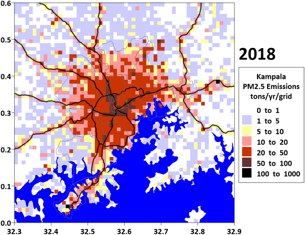 | ||
| Fig. 5 Gridded annual PM2.5 emissions for the Greater Kampala region in 2018. | ||
The spatial disaggregation of total emissions into grid-based estimates is an iterative process guided by several simple rules for initial allocation. For instance, heavy-duty truck emissions are concentrated along highways, while passenger vehicle emissions are primarily found along primary and secondary roads and within grids with higher urban built-up areas. Emissions from residential cooking and open waste burning align with population density, taking into account urban–rural classifications, fuel mix, and waste collection rates. Road dust emissions are distributed according to road density metrics, and industrial emissions are assigned to their specific grid locations based on precise location data. The weights assigned to these proxies may vary, and to increase confidence in the final inventory, the iterative process is validated against monitoring data using a chemical transport model. The first look of the gridded emissions in Fig. 5 overlaps with a combination of road and population density.
Temporal variations in emissions are also incorporated as key time-dependent inputs for the chemical transport models. For example, to prevent overestimation, precipitation rates from meteorological models are used to adjust dust emissions by canceling emissions for any hour and grid with precipitation exceeding 0.1 mm h−1. Additionally, the diurnal trends observed in ambient monitoring data (Fig. 3) serve as proxies for the transport sector, helping to designate rush hours.
There are uncertainties in this approach, spanning from the emissions modeling step to validation. The emission estimation process relies on assumptions and aggregate totals, which are subsequently disaggregated into grids using weights for each GIS proxy. Considering these uncertainties, the established inventory aims to quantify emission loads across all known sectors and identify ways to improve the information generation process. Overall, we estimate an average uncertainty of ±25% in the emission totals. Certain sectors, such as open waste burning, exhibit higher uncertainty, whereas industries with specific information on fuel sources and fuel consumption rates have lower uncertainty.
Emissions inventory work is an ongoing endeavor, as there is always room to improve estimates with the availability of new data, ranging from consumption patterns and user behavior to incentives or disincentives for policy adoption. Accurate inventories require the localization of inputs, such as vehicle usage characteristics,47 household energy use, and waste management patterns, to reflect the specific conditions of each area. The baseline inventory presented here serves as a foundational steppingstone for the next generation of inventories, providing a robust framework that can be enhanced and refined as more detailed and localized data become available. This continuous improvement process ensures that emissions inventories remain accurate and relevant, supporting effective air quality management and policy development.
3.2 Modeled PM2.5 concentrations and validation
The modeled monthly average PM2.5 concentration maps (Fig. 6a) illustrate the spatial and temporal variations in pollution levels across the airshed. These variations align with prevailing weather conditions, with lower concentrations during the rainy season (e.g., April to July) due to enhanced wet deposition and pollutant dispersion, and higher concentrations during the dry season (e.g., January, February, and December) because of stagnant atmospheric conditions and increased emissions. Differences in concentrations among the grids are driven by gridded emissions inputs (Fig. 5). Higher concentrations are observed in urban areas with dense populations and significant commercial activity, while concentrations taper off in rural regions with fewer anthropogenic emission sources. The maps clearly highlight pollution hotspots around the urban core, reflecting areas with intense transportation, industrial activity, and domestic emissions. The maps also reveal seasonal hotspots and changes in the spatial spread of pollution. For example: (a) high concentrations in January and December cover larger areas of the urban region, suggesting intensified emissions from seasonal activities such as biomass burning, cooking, and possibly increased transportation (b) the spatial spread of pollution during the rainy season (April to July) is much narrower, with lower concentrations confined to the urban center, indicating the effectiveness of rain in reducing pollutant levels through wet deposition (c) post-rains the maps show a gradual return of higher concentrations starting in August, as dry conditions return, allowing pollutants to accumulate more readily. | ||
| Fig. 6 (a) Modelled monthly average PM2.5 concentrations for 2018 in μg m−3 (b) comparison of modelled monthly concentrations as a variation among the grids covering the monitoring stations and of the monitoring data as a variation among all the stations in a month and (c) modelled source contributions (as percent) to annual average PM2.5 concentrations including emission sources inside the airshed and the boundary conditions representing the sources outside the airshed. | ||
A comparison of monthly concentrations is also investigated – between the variation in the modelled concentrations for urban grids and the variation in the measured concentrations from all the stations (Fig. 6b). The orange error bars, and blue shaded region show the range (10th–90th percentile) of variation in the measured and modeled values, respectively. The model was able to qualitatively and quantitatively replicate the total PM2.5 concentrations, indicating that the spatial and temporal allocation schemes for the total emissions is a reasonable fit and this confidence interval can be used further to conduct emissions scenario analysis. Both measured and modeled concentrations show greater variability during dry months, potentially due to more localized or episodic pollution events, such as biomass burning and dust. This plot highlights the ability of the model to capture the seasonal trends reasonably well and underscores the importance of addressing seasonal and localized emission sources to improve air quality the model. While high concentrations were observed in the measurements during January and February, the model captured this only in January. This discrepancy arises from the emission load estimation during these months, influenced by two factors: local emissions (from this study) and boundary conditions, which are discussed in Fig. 4d and the following section. The latter includes year-to-year variations in the location and intensity of fires north of the city. This presents an opportunity to assess the sensitivity of the inventory to seasonal variations.
A copy of the total modelled concentrations at the grid level and by month is included in the ESI.† In comparison, the modelled concentrations are from grids covering a 2 km radius, which approximately translates into 9 grids (3 × 3) with the center grids containing the monitoring station. The wide network of (80+) monitoring stations covered most of the built-up urban grids in the airshed, providing a good sample of the monitored and modelled concentrations for comparison.
3.3 Modeled PM2.5 source apportionment
The CAMx modeling system enables source apportionment of PM2.5 pollution. We utilized a conventional brute-force method, where emissions from representative sectors were systematically removed from the total emissions to estimate their individual contributions. The total emissions were categorized into five broad sectors: transport, residential cooking, open waste burning, dust, and industries. This approach provides a clear understanding of the relative contributions of each sector to overall pollution levels, facilitating informed dialogue on mitigation strategies (Fig. 6c). Residual concentration is the contribution of the boundary conditions, representing the sources outside the airshed.The high concentrations in the month of Jan–Feb can be explained using the presence of fire emissions in the north (Fig. 4c), prevalent wind conditions from the north (Fig. 2) and high concentrations of secondary organic aerosols along the northern boundary of the airshed in the boundary conditions. The source apportionment pies by month are included in the ESI.† The boundary contributions are the highest for the months of Jan–Feb and the concentrations of the organic aerosols at the boundary (from the global model) are 5–8 times higher than those observed for the other months. In the chemical composition of PM2.5, organic carbon aerosols from open fires dominate the emissions profile. The VOCs released during these fires have sufficient retention time in the atmosphere to undergo chemical transformations, forming secondary organic aerosols as they travel from the northern boundary of Uganda to the city boundary. This process is captured in the boundary conditions of the model, reflecting the significant contribution of transported pollutants to urban air quality. For the remaining months, the source contributions are mostly local, making a case for an urban air quality management plan to tackle these emissions. A composite presentation with extracts from the global model boundary conditions highlighting the boundary contributions, an animation of open fire instances, source contributions by month, and total concentrations by month is included in the ESI.†
4 Policy and institutional mechanisms
An AQM plan is designed to achieve the national ambient air quality standards using a wide range of policy, institutional, technical and economic levers.48,49 For this to be a successful campaign, a foundational policy landscape is necessary which recognizes air quality as a priority problem to address. In Africa, there are known and some unknown knowledge gaps towards this campaign and there is a lack of explicit policy commitment, in most of the countries – in the past 20 years, only 5% of all the management strategies have been directed towards policy development.8,50 Despite similar lapses in Uganda, Uganda issued its first National Environment (Air Quality Standards) Regulations in 2024, as part of a series of explicit policy commitments since 1990, such as Traffic and Road Safety Act (1998); The Occupational Safety and Health Act (2006); The Kampala Capital City Authority (Amendment) Act, (2020); and The National Environment Act (2020).We propose an institutional framework that requires multi-level governance involving diverse stakeholders from international multilateral agencies, national, regional, sectoral, and local constituencies. In Kampala and Uganda, the institutional framework consists of a broad spectrum of actors (listed in Fig. 7), broadly covering the concepts of (a) policy development (b) sector interventions for clean air and (c) evidence generation and public engagement. In Uganda, the national institutional framework designates the Kampala Capital City Authority (KCCA) and the National Environment Management Authority (NEMA) as the primary agencies responsible for managing the local environment, including air quality. These entities collaborate closely with stakeholders from various line departments to ensure a coordinated approach to air quality management.
 | ||
| Fig. 7 The three-layered intervention framework and the stakeholder landscape for clean air action in Kampala. | ||
This three-layered structure in Fig. 7 is a synopsis developed from the review of the institutional mechanisms, policy landscape, existing actors in air quality community of Uganda and Kampala.50,51 Whilst this framework is for Uganda, the same can be applied with some localization in other African contexts. The framework adopts the stakeholder definition from the KCCA governance framework as ‘entities including government and non-governmental organisations/entities, and/or individuals that/could have particular interests in air quality or those who, by their mandate and existence (in the case of government institutions and permitted emitters) could have a role to play in air quality management’. Although the three-layered intervention framework emphasizes the interconnectedness of actions at different levels, the approaches of individual stakeholders often remain siloed. This underscores the challenge of sustaining trans-disciplinary collaborations, which require significant effort, resources, and coordination to bridge gaps and foster effective partnerships across sectors.52 While achieving full collaboration across disciplines is challenging in the early stages, we believe that positive outcomes over time can encourage stronger partnerships among different stakeholders. For example: The advances in the cities of Kampala and Nairobi exemplified by initiatives like the CLEAN-Air Network and the annual CLEAN-Air Forum as a mechanism that enables cross-border interdisciplinary collaborations, air quality awareness week, Nairobi Air Quality Working Group (N-Air), annual air quality awareness week among others.53 Consequently, broad-based and multi-regional collaboration umbrellas like the CLEAN-Air Network can address some of the underlying challenges associated with these collaborations.
In addition to the policy commitments and enabling legislation, air quality information in the form of ground measurements, satellite observations, consumption patterns, and development metrics, are a must to establish tailored interventions for clean air. The availability of reliable and open information (layer-2) is key to enable a successful public-policy dialogue for policy and legislation formation (layer-1) and for the preparation of tailored cost-beneficial interventions with least health impacts (layer-3). Our analysis of the transformation of the Greater Kampala airshed since 1990, suggests low importance given to information generation and usage for institutional support. In Kampala, the requisite capacity for establishing continuous monitoring network and conducting emissions and pollution analysis is in its nascent stages, and the efforts are underway to populate all the information layers to institutionalize the concept of integrated air quality management.29,50
5 Conclusions
Kampala is undergoing rapid urbanization as it transitions from a “market town” to a “production center”, resulting in significant changes to air quality and other environmental challenges in the region. Effective air quality management requires a clear understanding of both the levels of pollution and its sources. While various initiatives have established continuous monitoring infrastructure in Kampala, further efforts are needed to build a comprehensive and integrated air quality information baseline for the city. In this paper, we present a series of initial efforts to support this baseline, utilizing data from a ground monitoring network, satellite observations, emissions modeling, and source apportionment through a chemical transport model. Some specific proposals for taking this dialogue forward include the following:• Levering existing policy framework and the release of the National Environment (Air Quality Standards) Regulations (2024) to incorporate air quality at the planning stages of physical development projects e.g. during city urban planning and environmental impact assessments.
• Enhancing institutional capacity for data uptake and utility of air quality. This can include long-term course and training programs at the universities for the students or short-term training and capacity building courses for perspective managers and practitioners.
• Investment in continuous monitoring infrastructure in the public domain, using hybrid models combining regulatory grade monitors, calibrated low-cost sensors, emission inventory-based pollution models, land use regression models coupled with emerging machine learning techniques, and to expand the overall scope of the infrastructure to include both aerosols (PM2.5 like species) and gaseous species. These components of AQM also need to be incorporated into the core curriculum of institutional capacity building activities.
• Developing incentive mechanisms for regulated sectors to encourage self-monitoring and reporting of air pollution information, using a combination of regulatory and calibrated sensor networks. This will be an attempt to build a public-private partnership to expand the air quality monitoring network.
• Periodic modelling efforts with updates to energy consumption patterns, urban layout, and emissions can estimate changes in source contributions and track the impacts of laws, regulations, legislations, and targeted interventions on air quality. The modelling efforts can be expanded to include short-term air quality forecasting to inform the public and the public bodies of air quality levels for the next 3 days. This is an effective way to ensure reduction in the exposure levels, with advance actions on the ground.
• Support the evidence-driven awareness strategies for public bodies and public (especially the vulnerable population like the sick, children, and the old), using information baselines from a combination of ground and satellite monitoring and modelling efforts.
• Using information baselines and cost-benefit analysis methods to promote faster adoption of some interventions. For example: green mobility including car-free days, electric retrofits for motorcycles, non-motorized transport, traffic management systems, and waste management.
Data availability
All the data compiled for the emissions and pollution analysis, including a model-ready gridded emissions inventory covering the Greater Kampala airshed; a composite presentation summaries of monitoring data, satellite retrievals, emission activities, emissions inventory and pollution modelling; and some supporting extracts from open GIS databases is included at https://doi.org/10.5281/zenodo.11560003. Updated MS-Excel based emissions and pollution modelling tools to conduct a capacity building training at the universities and public body forums is available @ https://www.urbanemissions.info/tools. Datasets from the AirQo sensor network is publicly accessible @ https://platform.airqo.net/.Author contributions
D. O., S. K. G., and J. X. – conceptualization of the study, D. O. and S. K. G. – inception of the first draft and editing the final draft; S. K. G. and S. K. D. – satellite, emissions, and pollution data modelling, curation, and visualization; R. S., P. A., E. B., and P. G. – monitoring, data curation, data archiving, and visualization; D. O. and J. X. – project management; D. O., D. L., and AirQo team – outreach and engagement. All authors contributed to discussions, editing, and finalizing.Conflicts of interest
The authors declare no conflict of interest.Acknowledgements
Authors would like to acknowledge and thank the World Bank (Washington DC, USA) for supporting the initial phase (2019–20) of the analytical work. AirQo's monitoring program, stakeholder engagement and outreach activities were supported by Google.org grant #1904-57882 and the US State Department grant #SAQMIP22CA0256. The analysis and conclusions presented herein are exclusively those of the authors and do not represent the supporting organizations or the educational departments. AirQo team recognizes the support from the US Embassy in Kampala a key partner of the local air quality awareness initiatives and Kampala Capital City Authority and the National Environment Management Authority for championing the pilot initiatives including the first city air quality action plan in Uganda. We would also like to thank the anonymous reviewers for their suggested contributions to this manuscript.References
- E. A. Brakema, A. Tabyshova, R. M. J. J. van der Kleij, T. Sooronbaev, C. Lionis, M. Anastasaki, P. L. An, L. T. Nguyen, B. Kirenga, S. Walusimbi, M. J. Postma, N. H. Chavannes, J. F. M. van Boven, P. Le An, M. Anastasaki, A. Akylbekov, A. Barton, A. Bertsias, P. D. U. Binh, J. F. M. van Boven, E. A. Brakema, D. Burges, L. Cartwright, V. E. Chatzea, N. H. Chavannes, L. Cragg, T. N. Dang, I. Dautov, B. Emilov, I. Ferarrio, F. A. van Gemert, B. Hedrick, L. H. T. C. Hong, N. Hopkinson, E. Isaeva, R. Jones, C. de Jong, S. van Kampen, W. Katagira, B. Kirenga, J. Kjærgaard, R. M. J. J. van der Kleij, J. Kocks, L. T. T. Lan, T. T. D. Linh, C. Lionis, K. X. Loan, M. Mademilov, A. McEwen, P. Musinguzi, R. Nantanda, G. Ndeezi, S. Papadakis, H. Pinnock, J. Pooler, C. C. Poot, M. J. Postma, A. Poulsen, P. Powell, N. N. Quynh, S. Reventlow, D. Sifaki-Pistolla, S. Singh, T. Sooronbaev, J. C. de Sousa, J. Stout, M. S. Østergaard, A. Tabyshova, I. Tsiligianni, T. D. Tuan, J. Tumwine, L. T. Van, N. N. Vinh, S. Walusimbi, L. Warren, S. Williams and On behalf of the F. A. I. R. c., The socioeconomic burden of chronic lung disease in low-resource settings across the globe – an observational FRESH AIR study, Respir. Res., 2019, 20, 291 CrossRef PubMed.
- HEI-SoGA, State of global air (SOGA), A Special Report on Global Exposure to Air Pollution and its Health Impacts, Health Effects Institute, Boston, USA, 2024 Search PubMed.
- A. Abera, J. Friberg, C. Isaxon, M. Jerrett, E. Malmqvist, C. Sjöström, T. Taj and A. M. Vargas, Air Quality in Africa: Public Health Implications, Annu. Rev. Publ. Health, 2021, 42, 193–210 CrossRef PubMed.
- H. Wipfli, A. Kumie, L. Atuyambe, O. Oguge, E. Rugigana, K. Zacharias, B. Simane, J. Samet and K. Berhane, The GEOHealth Hub for Eastern Africa: Contributions and Lessons Learned, GeoHealth, 2021, 5, e2021GH000406 CrossRef PubMed.
- G. Okello, R. Nantanda, L. Tata, R. Sserunjogi, J. Olatunji, B. Awokola, D. Okure, M. Thondoo, P. Green and O. Babajide, Association between Ambient Air Pollution and Respiratory Health in Kampala, Uganda: Implications for Policy and Practice, Urban Climate, 2024, 58, 102128 CrossRef.
- S. Fisher, D. C. Bellinger, M. L. Cropper, P. Kumar, A. Binagwaho, J. B. Koudenoukpo, Y. Park, G. Taghian and P. J. Landrigan, Air pollution and development in Africa: impacts on health, the economy, and human capital, Lancet Planet. Health, 2021, 5, e681–e688 CrossRef PubMed.
- S. Gani, P. Pant, S. Sarkar, N. Sharma, S. Dey, S. K. Guttikunda, K. M. AchutaRao, J. Nygard and A. D. Sagar, Systematizing the approach to air quality measurement and analysis in low and middle income countries, Environ. Res. Lett., 2022, 17, 021004 CrossRef.
- R. M. Garland, K. E. Altieri, L. Dawidowski, L. Gallardo, A. Mbandi, N. Y. Rojas and N. d. E. Touré, Opinion: Strengthening Research in the Global South: Atmospheric Science Opportunities in South America and Africa, EGUsphere, 2023, vol. 2023, pp. 1–14 Search PubMed.
- A. Singh, W. R. Avis and F. D. Pope, Visibility as a proxy for air quality in East Africa, Environ. Res. Lett., 2020, 15, 084002 CrossRef CAS.
- R. Roy, The Cost of Air Pollution in Africa, 2016, DOI:10.1787/5jlqzq77x6f8-en.
- E. P. Petkova, D. W. Jack, N. H. Volavka-Close and P. L. Kinney, Particulate matter pollution in African cities, Air Qual. Atmos. Health, 2013, 6, 603–614 CrossRef CAS.
- C. Liousse, E. Assamoi, P. Criqui, C. Granier and R. Rosset, Explosive growth in African combustion emissions from 2005 to 2030, Environ. Res. Lett., 2014, 9, 035003 CrossRef CAS.
- P. D. M. C. Katoto, L. Byamungu, A. S. Brand, J. Mokaya, H. Strijdom, N. Goswami, P. De Boever, T. S. Nawrot and B. Nemery, Ambient air pollution and health in Sub-Saharan Africa: Current evidence, perspectives and a call to action, Environ. Res., 2019, 173, 174–188 CrossRef CAS PubMed.
- S. Keita, C. Liousse, E. M. Assamoi, T. Doumbia, E. T. N'Datchoh, S. Gnamien, N. Elguindi, C. Granier and V. Yoboué, African anthropogenic emissions inventory for gases and particles from 1990 to 2015, Earth Syst. Sci. Data, 2021, 13, 3691–3705 CrossRef.
- E. E. McDuffie, R. V. Martin, J. V. Spadaro, R. Burnett, S. J. Smith, P. O'Rourke, M. S. Hammer, A. van Donkelaar, L. Bindle, V. Shah, L. Jaeglé, G. Luo, F. Yu, J. A. Adeniran, J. Lin and M. Brauer, Source sector and fuel contributions to ambient PM2.5 and attributable mortality across multiple spatial scales, Nat. Commun., 2021, 12, 3594 CrossRef CAS PubMed.
- S. E. Vollset, H. S. Ababneh and C. J. L. Murray, GBD-Collaborators, Burden of disease scenarios for 204 countries and territories, 2022-2050: a forecasting analysis for the Global Burden of Disease Study 2021, Lancet, 2024, 403, 2204–2256 CrossRef PubMed.
- A. Mazzeo, M. Burrow, A. Quinn, E. A. Marais, A. Singh, D. Ng'ang'a, M. J. Gatari and F. D. Pope, Evaluation of WRF-CHIMERE coupled models for the simulation of PM2.5 in large East African urban conurbations, Atmos. Chem. Phys. Discuss., 2022, 2022, 1–31 Search PubMed.
- F. Karagulian, C. A. Belis, C. F. C. Dora, A. M. Prüss-Ustün, S. Bonjour, H. Adair-Rohani and M. Amann, Contributions to cities' ambient particulate matter (PM): A systematic review of local source contributions at global level, Atmos. Environ., 2015, 120, 475–483 CrossRef CAS.
- D. Okure, J. Ssematimba, R. Sserunjogi, N. L. Gracia, M. E. Soppelsa and E. Bainomugisha, Characterization of Ambient Air Quality in Selected Urban Areas in Uganda Using Low-Cost Sensing and Measurement Technologies, Environ. Sci. Technol., 2022, 56, 3324–3339 CrossRef CAS PubMed.
- O. Ghaffarpasand, D. Okure, P. Green, S. Sayyahi, P. Adong, R. Sserunjogi, E. Bainomugisha and F. D. Pope, The impact of urban mobility on air pollution in Kampala, an exemplar sub-Saharan African city, Atmos. Pollut. Res., 2024, 15, 102057 CrossRef CAS.
- P. Adong, E. Bainomugisha, D. Okure and R. Sserunjogi, Applying machine learning for large scale field calibration of low-cost PM2.5 and PM10 air pollution sensors, Appl. AI lett., 2022, 3, e76 CrossRef.
- P. Green, D. Okure, P. Adong, R. Sserunjogi and E. Bainomugisha, Exploring PM2.5 variations from calibrated low-cost sensor network in Greater Kampala, during COVID-19 imposed lockdown restrictions: Lessons for Policy, Clean Air J., 2022, 32, 1–14 Search PubMed.
- S. K. Guttikunda, V. B. Zlatev, S. K. Dammalapati and K. C. Sahoo, Mapping PM2.5 Sources and Emission Management Options for Bishkek, Kyrgyzstan, Air, 2024, 2, 362–379 CrossRef.
- UBOS, Report on the Census of Business Establishment 2010/11, Uganda Bureau of Statistics, Kampala, Uganda, 2011 Search PubMed.
- UBOS, Solid Fuel Mapping (Raw Data), Uganda Bureau of Statistics, Kampala, Uganda, 2015 Search PubMed.
- UBOS, The National Population and Housing Census 2014, Uganda Bureau of Statistics, Kampala, Uganda, 2016 Search PubMed.
- M. Pesaresi, D. Ehrilch, A. J. Florczyk, S. Freire, A. Julea, T. Kemper, P. Soille and V. Syrris, GHS Built-Up Grid, Derived from Landsat, Multitemporal (1975, 1990, 2000, 2014), European Commission, Joint Research Centre, JRC Data Catalogue, 2015 Search PubMed.
- K. Sims, A. Reith, E. Bright, J. Kaufman, J. Pyle, J. Epting, J. Gonzales, D. Adams, E. Powell, M. Urban and A. Rose, LandScan Global, 2022, Oak Ridge National Laboratory, 2023, DOI: DOI:10.48690/1529167.
- R. Sserunjogi, J. Ssematimba, D. Okure, D. Ogenrwot, P. Adong, L. Muyama, N. Nsimbe, M. Bbaale and E. Bainomugisha, Seeing the air in detail: Hyperlocal air quality dataset collected from spatially distributed AirQo network, Data Brief, 2022, 44, 108512 CrossRef CAS PubMed.
- E. Bainomugisha, J. Ssematimba and D. Okure, Design Considerations for a Distributed Low-Cost Air Quality Sensing System for Urban Environments in Low-Resource Settings, Atmosphere, 2023, 14(2), 354 CrossRef.
- S. Dammalapati and S. K. Guttikunda, Data from small monitoring networks is unreliable: Case of Indian cities, SIM-Air Working Paper Series #47-2024 and #48-2024, UrbanEmissions.Info, New Delhi, India, 2024, DOI:10.2139/ssrn.4956327.
- S. V. Matagi, Some Issues of Environmental Concern in Kampala, the Capital City of Uganda, Environ. Monit. Assess., 2002, 77, 121–138 CrossRef CAS PubMed.
- S. Schwander, C. D. Okello, J. Freers, J. C. Chow, J. G. Watson, M. Corry and Q. Meng, Ambient Particulate Matter Air Pollution in Mpererwe District, Kampala, Uganda: A Pilot Study, J. Environ. Publ. Health, 2014, 2014, 763934 Search PubMed.
- A. Van Donkelaar, R. V. Martin, M. Brauer, N. C. Hsu, R. A. Kahn, R. C. Levy, A. Lyapustin, A. M. Sayer and D. M. Winker, Global Estimates of Fine Particulate Matter using a Combined Geophysical-Statistical Method with Information from Satellites, Models, and Monitors, Environ. Sci. Technol., 2016, 50, 3762–3772 CrossRef CAS PubMed.
- A. van Donkelaar, M. S. Hammer, L. Bindle, M. Brauer, J. R. Brook, M. J. Garay, N. C. Hsu, O. V. Kalashnikova, R. A. Kahn, C. Lee, R. C. Levy, A. Lyapustin, A. M. Sayer and R. V. Martin, Monthly Global Estimates of Fine Particulate Matter and Their Uncertainty, Environ. Sci. Technol., 2021, 55, 15287–15300 CrossRef CAS PubMed.
- X. Wang, R. Brown, G. Prudent-Richard and K. O'Mara, Africa Clean Cooking Energy Solutions Initiative, ESMAP, The World Bank, Washington DC, USA, 2017 Search PubMed.
- S. Hankey, K. Sullivan, A. Kinnick, A. Koskey, K. Grande, J. H. Davidson and J. D. Marshall, Using objective measures of stove use and indoor air quality to evaluate a cookstove intervention in rural Uganda, Energy Sustain. Dev., 2015, 25, 67–74 CrossRef CAS.
- S. V. Lall, J. V. Henderson and A. J. Venables, Africa's Cities: Opening Doors to the World, The World Bank, Washington DC, USA, 2017 Search PubMed.
- World-Bank, Uganda-from Regulators to Enablers: Role of City Governments in Economic Development of Greater Kampala, The World Bank, Washington DC, USA, 2018 Search PubMed.
- P. Failler, P. Karani and W. Seide, Assessment of the Environment Pollution and its impact on Economic Cooperation and Integration Initiatives of the IGAD Region, National Environment Pollution Report, Uganda, 2016 Search PubMed.
- KCCA, Strategic Plan 2014/15-2018/19, Kampala Capital City Authority, Kampala, Uganda, 2016, https://www.kcca.go.ug/opengov Search PubMed.
- MoWT, Road Design Manual Volume Geometric Design, Ministry of Works and Transport, Kampala, Uganda, 2010 Search PubMed.
- UEinfo, Air Pollution knowledge Assessments (APnA) city program covering 50 airsheds and 60 cities in India, 2024, https://www.urbanemissions.info.
- S. K. Guttikunda, K. A. Nishadh and P. Jawahar, Air pollution knowledge assessments (APnA) for 20 Indian cities, Urban Clim., 2019, 27, 124–141 CrossRef.
- S. K. Guttikunda and R. V. Kopakka, Source emissions and health impacts of urban air pollution in Hyderabad, India, Air Qual. Atmos. Health, 2013, 7, 195–207 CrossRef.
- GAINS, Greenhouse Gas and Air Pollution Interactions and Synergies (GAINS), https://iiasa.ac.at/models-tools-data/gains, (accessed 15 June, 2024).
- S. K. Guttikunda, N. Ka, V. Tejaswi, R. Goel, Fuel Station Survey (FuSS) to Profile In-Use Vehicle Characteristics, SIM-air Working-Paper, 2025, 56, DOI:10.2139/ssrn.5161009.
- P. S. Monks and M. L. Williams, What does success look like for air quality policy? A perspective, Philos. Trans. R. Soc., A, 2020, 378, 20190326 CrossRef CAS PubMed.
- L. Andres, J. R. Bryson, H. Bakare and F. Pope, Institutional logics and regional policy failure: Air pollution as a wicked problem in East African cities, Environ. Plan. C Politics Space, 2022, 41, 313–332 CrossRef.
- G. Okello, R. Nantanda, B. Awokola, M. Thondoo, D. Okure, L. Tatah, E. Bainomugisha and T. Oni, Air quality management strategies in Africa: A scoping review of the content, context, co-benefits and unintended consequences, Environ. Int., 2023, 171, 107709 CrossRef PubMed.
- E. Bainomugisha, P. Adrine Warigo, F. Busigu Daka, A. Nshimye, M. Birungi and D. Okure, AI-driven environmental sensor networks and digital platforms for urban air pollution monitoring and modelling, Soc. Impact, 2024, 3, 100044 CrossRef.
- M. A. Thompson, S. Owen, J. M. Lindsay, G. S. Leonard and S. J. Cronin, Scientist and stakeholder perspectives of transdisciplinary research: Early attitudes, expectations, and tensions, Environ. Sci. Pol., 2017, 74, 30–39 CrossRef.
- AirQo, The CLEAN-Air Network, Kampala, Uganda, 2024, Available at: https://www.airqo.net/cleanair/about (Accessed: 08 June 2024) Search PubMed.
Footnote |
| † Electronic supplementary information (ESI) available. See DOI: https://doi.org/10.5281/zenodo.11560003 |
| This journal is © The Royal Society of Chemistry 2025 |