
Spatial uncertainty of joint health risk of multiple trace metals in rice grain in Jiaxing city, China
Mingkai
Qu
a,
Biao
Huang
*a,
Weidong
Li
b,
Chuanrong
Zhang
b and
Yongcun
Zhao
a
aKey Laboratory of Soil Environment and Pollution Remediation, Institute of Soil Science, Chinese Academy of Sciences, 210008 Nanjing, China. E-mail: bhuang@issas.ac.cn; Fax: +86-25-86991000; Tel: +86-25-86881302
bDepartment of Geography and Center for Environmental Sciences and Engineering, University of Connecticut, Storrs, Connecticut 06269, USA
First published on 31st October 2014
Abstract
Trace metals in rice may affect human health if their concentrations reach risk levels in the human body due to long-term ingestion. In this study, concentrations of five trace metals (Cd, Cr, Cu, Pb and Zn) in field-sampled rice grains were measured at 285 sampling sites in Jiaxing city, China. The objective was to map the spatial distribution and uncertainty of the potential human health risk of trace metals in local rice grains at a regional scale. The probability map of multiple trace metals that tend to be hazardous was produced based on the permissible limits in Chinese National Standards. It showed higher probabilities, which exceeded the national standards, for one or more of trace metals in rice grains were mainly located in several small subareas around the center of the study area. We used the Target Hazard Quotient (THQ) index and the Total THQ (TTHQ) index to represent the potential human health risks caused by individual and multiple trace metals in local rice grains. The TTHQ was essentially regarded as an integrative uniform rice quality index in this study. Stochastic simulation was then conducted to simulate the TTHQ for mapping the spatial distribution and uncertainty of the total potential health risk. Probability maps of different risk grades for TTHQ indicated that most places were in unsafe grades. In general, maps of site-specific health risks posed by trace metals in local rice grains and associated uncertainty information are valuable to spatial decision making in agricultural planning, rice uses, and environmental management.
Environmental impactThe joint effect of multiple trace metals in crops was seldom dealt with for estimating standard-exceeding probabilities and mapping potential health risks and the corresponding uncertainties at a regional scale. In this study, we mapped the joint standard-exceeding probabilities of trace metals in rice grains in the study area using multiple-variable indicator kriging, simulated the joint health risk index of five trace metals (Cd, Cr, Cu, Pb and Zn) in rice grains and assessed the spatial uncertainty of the joint health risk using the sequential indicator simulation method. Such spatial uncertainty information of joint risk would be useful for decision makers in crop quality management, food uses and environmental management. |
1. Introduction
Trace metal elements in food can be harmful even at a very low concentration level if ingested by humans over a long period of time.1,2 Sharma et al.3 found that food consumption had been the major pathway of human exposure to trace metals except for occupational exposures. Therefore, the Food and Agriculture Organization (FAO) and Word Health Organization (WHO) of United Nations, United States Environment Protection Agency (US EPA) and other regulatory bodies in different countries strictly regulated the allowable concentrations or maximum permitted concentrations of toxic trace metals in foodstuffs.4,5The non-carcinogenic risk assessment method based on the Target Hazard Quotient (THQ) index was provided by US EPA.6 In recent years, this method has been commonly used for human health risk assessment. For example, Hough et al.7 used predicted concentrations of metals in selected vegetables to assess the risk of exposure to human populations from homegrown food sources and also estimated the risks from other exposure pathways (consumption of commercially produced foodstuffs, dust inhalation, and soil ingestion) in West Midlands, United Kingdom; Wang et al.8 estimated human health risks of several trace metals to the public through the consumption of vegetables and fish in four districts and the urban area of Tianjin using the THQ index; Bermudez et al.9 evaluated trace metal concentrations in wheat grains and straws collected in the vicinities of industries in Argentina and assessed the non-carcinogenic risk of wheat grain consumption; and Fontúrbel et al.10 calculated the average THQ value of lead present in indoor dust caused by mining and metallurgical activities. More recently, Li et al.11 investigated the translocation of trace metals from soils to edible parts of crops and evaluated their potential health risks to local residents.
In fields, the concentrations of trace metals in crop grains are normally spatially heterogeneous at regional scales due to a variety of environmental impact factors. Consequently, the potential human health risk posed by trace metals in local crop grains should also be similarly spatially heterogeneous in terms of crop growth locations and local environment. However, such spatial heterogeneity was seldom considered in early studies on the assessment of health risks of trace metals through human consumption. It is obvious that understanding the spatial variability of the potential human health risk caused by toxic trace metals in local crop grains in an agricultural area is crucial for spatial decision making in crop quality management, food uses and environmental management. Geostatistical methods have been often used in modeling the spatial variability of trace metals in soil and assessing their spatial uncertainty.12,13 However, to the best of our knowledge, studies on geostatistical spatial assessment of the potential human health risk posed by trace metals in local crop grains have not been reported in literature to date. Spatial uncertainty is an intrinsic characteristic in the spatial distributions of trace metals in rice in the fields due to limited observation points, and such uncertainty can consequently cause spatial uncertainty in the estimation of the potential human health risk of trace metals in rice. The spatial uncertainty information of THQ could be valuable to spatial decision making in rice and environmental management.
Geostatistical stochastic simulation has been frequently used to characterize the spatial patterns and uncertainty of contaminants in water and soils.12,14 The spatial uncertainty of the potential health risk caused by the contaminants may be further assessed through uncertainty propagation using simulated realizations.15–18 However, previous studies in mapping potential human health risks and corresponding uncertainties were mainly focused on one single pollutant or investigating multiple pollutants separately, and thus did not effectively deal with the joint effect of multiple pollutants. One way to deal with the joint effect of multiple pollutants in health risk assessment is to simulate each pollutant separately, and then import a group of randomly selected realizations, one for each pollutant, into a human health risk assessment model to obtain one realization of the total health risk index of multiple pollutants; however, this method has obvious drawbacks in computation.19 The other way is to import the sample data of multiple pollutants directly into a health risk model and obtain the index of the total health risk caused by them as a set of sample data of a continuous variable, which contains the joint effects of multiple pollutants. Then, we may use a geostatistical simulation method to simulate the spatial distribution of the continuous health risk index and quantify its spatial uncertainty. In this study, the second method was adopted, i.e., we first calculated the total target hazard quotient (TTHQ) of five trace metals in field-sampled rice grains at every sampling site, then simulated the spatial distribution of TTHQ to evaluate its spatial variability in the study area, and finally used simulated realizations to assess the probability maps of the TTHQ falling into different health risk grades.
Risk assessment at unsampled locations is important in delineation of contamination areas.20–23 However, rice grains might be polluted by several trace metals in a study area. As such, spatial estimation with multiple indices is required for mapping the areas polluted by multiple contaminants.24–27 In addition, probability maps of multiple hazardous pollutants together are also needed for rice quality investigations. As a multiple-index approach, multiple-variable indicator kriging (MVIK) may serve such a purpose by providing more conservative information and scenarios than single-variable indicator kriging.28,29
The specific objectives of this study include (1) mapping the occurrence probabilities of hazardous rice in the field in the study area based on the permissible limits as defined in terms of the Chinese National Standards; (2) exploring the spatial distribution pattern of the total potential human health risk posed by five trace metals (Cd, Cr, Cu, Pb and Zn) in field-sampled rice grains; and (3) assessing the spatial uncertainty of the potential human health risk using simulated realization maps. In fact, in this study, the potential human health risk of trace metals in rice grains, represented by the TTHQ, was essentially used as an integrative and uniform index for evaluating the quality of rice grains growing in fields in a study area. The spatial heterogeneity information of the potential human health risk of trace metals in field-sampled rice grains should be useful for decision makers in grain processing, environmental management and agricultural planning.
2. Materials and methods
2.1. Study area and data
The study was conducted in Jiaxing city (120°18′ and 121°16′ E, 30°21′ and 31°2′ N), a part of the Taihu Plain in northeast Zhejiang Province, with an area of 3915 km2 and a population of 3![[thin space (1/6-em)]](https://www.rsc.org/images/entities/char_2009.gif) 356000 (at the end of 2006, Fig. 1). It is an economically rapidly developing region in east China. Due to the distribution of dense river networks and abundant water resources, Jiaxing is a typical agricultural area, where rice is the major food crop. It belongs to the northern subtropical monsoonal climate zone with four distinct seasons. The average annual temperature and precipitation are 15.9 °C and 1168.6 mm, respectively. Soil types are anthrosols,30 which are derived from lacustrine alluvium through long-term paddy cultivation. Since early 1990s, this area has experienced a remarkable development in industry, and various industrial sectors are distributed around urban areas.
356000 (at the end of 2006, Fig. 1). It is an economically rapidly developing region in east China. Due to the distribution of dense river networks and abundant water resources, Jiaxing is a typical agricultural area, where rice is the major food crop. It belongs to the northern subtropical monsoonal climate zone with four distinct seasons. The average annual temperature and precipitation are 15.9 °C and 1168.6 mm, respectively. Soil types are anthrosols,30 which are derived from lacustrine alluvium through long-term paddy cultivation. Since early 1990s, this area has experienced a remarkable development in industry, and various industrial sectors are distributed around urban areas.
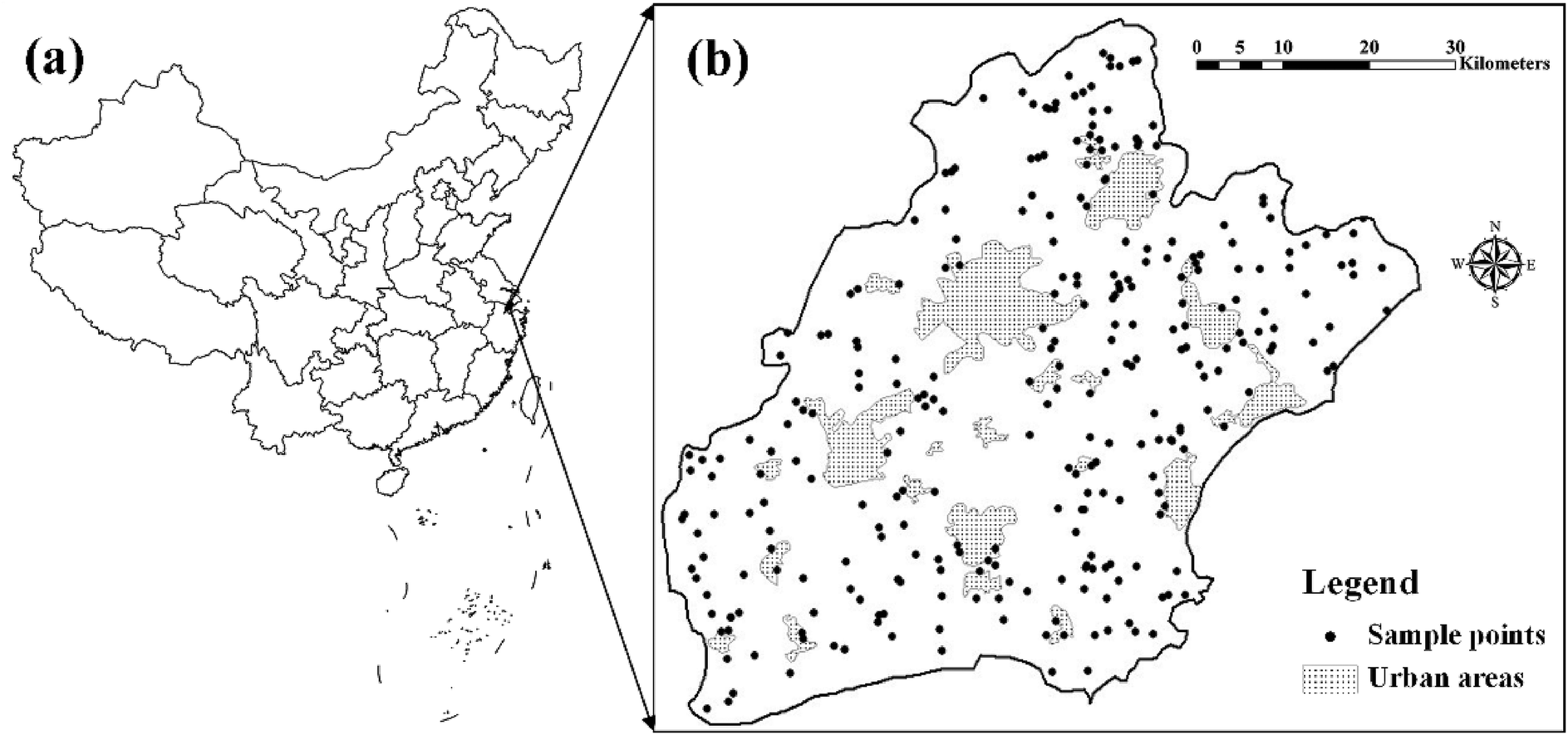 | ||
| Fig. 1 The location of the study area in China (a) and the sampling sites for measuring trace metals in rice in Jiaxing city, Zhejiang province (b). | ||
An investigation on trace metals in local rice grains was performed in October 2006. Sampling was performed randomly in paddy fields for aquatic rice production, and mountain and urban areas were avoided. Two hundred and eighty-five rice grain samples were collected in the study area (Fig. 1). The rice genotype in this area was mainly japonica rice cultivar Xiushui 63. Rice plants at grain maturity (just before harvest) were cut underneath the ear with scissors. At each sampling point, 4–5 sub-samples were randomly chosen to obtain a composite rice grain sample. Grain samples were oven-dried at 38 °C till a constant weight was obtained. Dried samples were first hulled, and then ground using a stainless steel grinder into powder (<0.25 mm) for metal analysis. The total concentrations of trace metals in rice samples were measured according to the standard methods in China.31 The prepared rice grain samples were stored in polyethylene bottles. A portion of each sample was first digested in a mixture of nitric acid (HNO3) and perchloric acid (HClO4),31 and then the total concentrations of Cd, Cr, Cu and Pb in the digested solution were measured with graphite furnace atomic absorption spectrophotometer (GFAAS) and that of Zn was measured with flame atomic absorption spectrophotometer (FAAS). For quality assurance and quality control duplicates, method blanks and standard reference materials were also analyzed.
2.2. Potential human health risk
The potential human health risk from consumption of rice was assessed based on the THQ, which is a ratio between the exposure and reference doses. This non-carcinogenic risk assessment method was provided by US EPA.32 Dose calculations were carried out using standard assumptions from an integrated United States EPA risk analysis. A THQ value <1.0 indicates that the level of exposure is smaller than the reference dose. A daily exposure at this level is believed to be unlikely to cause any adverse effect during a person's lifetime. The model for estimating THQ6 is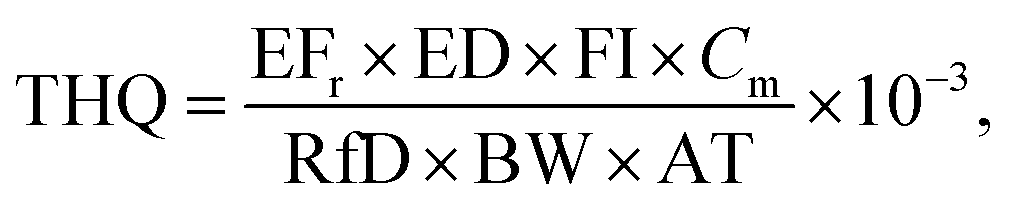 | (1) |
| Trace metal | Minimum | Maximum | Mean | S.D. | C.V. (%) | Thresholda | Numberb | Ratioc (%) |
|---|---|---|---|---|---|---|---|---|
| a Permissible limits in Chinese National Standards.35–37 b Number of sampling sites where trace metal concentrations exceed corresponding permissible limits. c Ratio = number/285; note that 285 is the total number of samples. | ||||||||
| Cd | 0.0008 | 0.2050 | 0.0163 | 0.0223 | 136.17 | 0.20 | 2 | 0.70 |
| Cr | 0.0018 | 1.5354 | 0.4733 | 0.2494 | 52.69 | 1.00 | 5 | 1.75 |
| Cu | 0.1649 | 10.1958 | 2.7021 | 0.9960 | 36.86 | 10.00 | 1 | 0.35 |
| Pb | 0.0009 | 2.9747 | 0.2096 | 0.3672 | 175.19 | 0.20 | 100 | 35.09 |
| Zn | 2.0242 | 28.5000 | 16.6449 | 3.2723 | 19.66 | 50.00 | 0 | 0.00 |
It has been reported that exposure to two or more pollutants may result in additive and/or interactive effects.39 In order to assess the overall potential non-carcinogenic effect posed by more than one trace metals, the TTHQ is treated as the arithmetic sum of the THQ values of individual metals,6,9,40i.e.,
 | (2) |
In this study, we applied the THQ and TTHQ indices to the spatial data of trace metals in field-sampled rice grains. The calculated THQ and TTHQ indices were used to represent the potential human health risks posed by single and multiple trace metals in local rice grains, respectively.
2.3. Geostatistical methods
 | (3) |
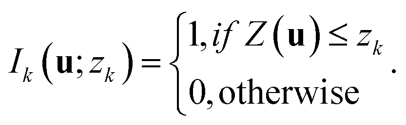
If the concentration of a trace metal exceeds zk, its indicator value is 0; otherwise it takes 1.
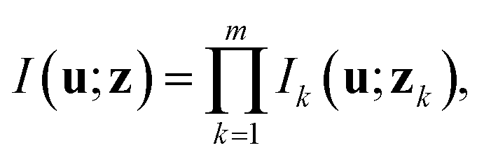
In MVIK, the integration of concentration indicators of multiple trace metals is achieved through multiplication of multiple indicator variables,26 which are defined as
 | (4) |
The probability for the concentrations of all trace metals in rice not to exceed their corresponding thresholds, which is conditional on n surrounding data, is expressed as
| Prob{Z(u) ≤ z|(n)} = F(u;z|(n)) = E[I(u;z|(n))], | (5) |
 | (6) |
 | (7) |
Eqn (7) indicates that a hazard exists if any one of multiple trace metals exceeds its corresponding threshold.
In this study, five cutoff values were selected, which are 1.09 (16.67% percentile), 1.27 (33.33% percentile), 1.50 (50% percentile), 1.74 (66.67% percentile) and 2.09 (83.33%). Thus, five sets of indicator data under these cutoff values were obtained to build the ccdf. We chose only five cutoff values because indicator variograms at extreme thresholds are usually not well defined and order relation problems may occur when many cutoff values are used.12,42 Using the total 285 TTHQ data for the five trace metals in field-sampled local rice grains in Jiaxing city, a conditional stochastic simulation using SIS was performed to map the spatial distribution of the potential human health risk and quantitatively assess the associated uncertainty. For the detailed procedure of SIS, see Deutsch and Journel.41
 | (8) |
| Safe grade | Grade 1 | Grade 2 | Grade 3 |
|---|---|---|---|
| TTHQ < 1 | 1.5 > TTHQ ≥ 1 | 2 > TTHQ ≥ 1.5 | TTHQ ≥ 2 |
In this study, all geostatistical analyses were performed on a regular square grid with a cell size of 400 m × 400 m. The cell size was mainly determined based on the size of the study area for the purpose of clearly displaying the resulting maps.
3. Results and discussions
3.1. Descriptive statistical analysis of trace metal concentrations in rice samples
A descriptive statistical summary of sample data for concentrations of the five trace metals (i.e., Cd, Cr, Cu, Pb and Zn) in field-sampled rice grains is listed in Table 1. The mean concentration of Pb in rice grains is slightly higher than its corresponding permissible limit in Chinese National Standards,35–37 and about 35% of sampling sites have Pb concentrations higher than the maximum allowable level (Table 1). Although the average concentrations of Cd, Cr and Cu in rice samples do not reach their pollution levels, their maximum values show that they may have reached the pollution level at some places in the region. This indicates that certain trace metals, especially Pb, have enriched in rice grains, and thus may pose a threat to human health. Therefore, it is necessary to intensively monitor the concentration status of these trace metals in rice in the studied region and evaluate their potential hazard to human beings.3.2. Probability estimation of trace metals that tend to be hazardous
Because no apparent anisotropy was found from the integrated multiple-variable indicator data set, which was coded from the concentrations of the trace metals based on their respective permissible limits in Chinese National Standards, the experimental variogram was estimated omni-directly. The experimental variogram is presented in Fig. 2 with a well-fitted spherical model. As trace metal concentrations in field-sampled rice grains typically vary with spatial locations, we estimated the probability map and observed that some (one or more) of the five trace metals exceed their corresponding permissible limits in concentration using MVIK. Fig. 3 shows the estimated probability map, in which a higher probability represents a greater hazard from the trace metals to human health. It can be seen that some small areas with higher probabilities occur in the southeast, southwest, northeast and northwest parts of the study region.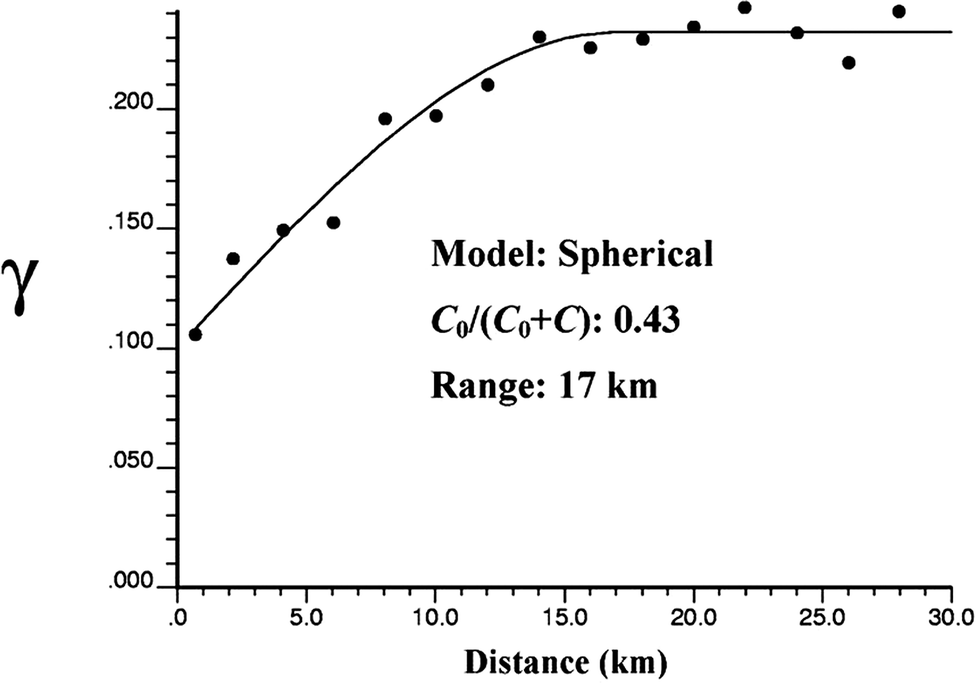 | ||
| Fig. 2 Experimental indicator variogram and fitted model, which are estimated from the integrated multiple-variable indicator data for the concentrations of the five trace metals in rice. | ||
 | ||
| Fig. 3 Estimated probabilities of the five trace metals that tend to be hazardous according to the permissible limits in Chinese National Standards. | ||
3.3. Spatial distribution of potential human health risk
The descriptive statistics of THQs for individual metals and the TTHQ for multiple metals in rice in Jiaxing city, which are calculated from field sample data based on adult consumption, are given in Table 3. While the average THQs for individual trace metals are all within the safe grade (i.e., <1.0), the average TTHQ (1.6954) for multiple trace metals exceeds 1.0, indicating that the total effect of multiple trace metals in local rice grains poses a potential threat to human health.| Health risk | Minimum | Maximum | Mean | S.D. | C.V. (%) |
|---|---|---|---|---|---|
| THQ_Cd | 0.0064 | 1.8089 | 0.1443 | 0.1965 | 136.17 |
| THQ_Cr | 0.0000 | 0.0090 | 0.0028 | 0.0015 | 52.79 |
| THQ_Cu | 0.0364 | 2.2497 | 0.5962 | 0.2198 | 36.86 |
| THQ_Pb | 0.0019 | 6.5637 | 0.4624 | 0.8102 | 175.20 |
| THQ_Zn | 0.0596 | 0.8385 | 0.4897 | 0.0963 | 19.66 |
| TTHQ | 0.5521 | 9.2690 | 1.6954 | 0.9524 | 56.18 |
The five cutoff values mentioned in Section 2.3.2. were used to perform indicator transformation of TTHQ values for simulation using SIS. Corresponding variograms of the five indicator data sets of TTHQ are presented in Fig. 4. All of these indicator variograms have obvious spatial variation structures. This indicates that using the five cutoff values is appropriate for estimating the global variation of TTHQ in the study area.
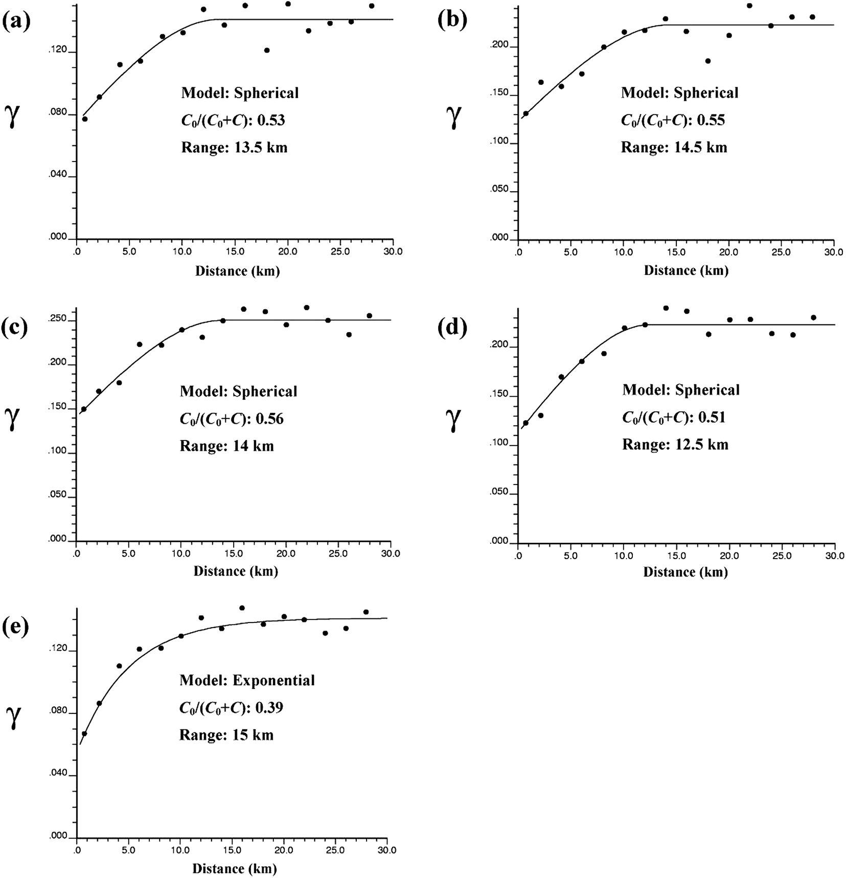 | ||
| Fig. 4 Experimental indicator variograms and fitted models for the five TTHQ thresholds: (a) 1.09, (b) 1.27, (c) 1.50, (d) 1.74 and (e) 2.09. | ||
Two realizations of TTHQ, which are randomly selected from the 500 realizations simulated by SIS, are shown in Fig. 5. Each realization may represent a possible reality of the spatial distribution of TTHQ without smoothing effect, and a set of realizations can effectively reveal the spatial distribution patterns of TTHQ and the associated uncertainty. The E-type estimate (E here refers to mathematical “expectation”), which is also known as the conditional mean, was calculated by averaging the 500 realizations. The E-type estimate and three histograms, which correspond to the 500 simulated values of TTHQ at three different sites, are shown in Fig. 6. The E-type estimate map shows the average global distribution trend of TTHQ in Jiaxing city: patches with higher simulated values mainly occur in the east part of the study area, whereas lower simulated values mostly appear in the central subarea of the region. Apparently, the E-type estimate map (Fig. 6) is smoother than the two randomly selected realization maps (see Fig. 5). This is expected because the E-type estimate map is a point-by-point average map of a number of simulated realizations and such a map should converge approximately to a kriged map when the number of realizations is very large.43 The three histograms demonstrate that the local probability distributions at different places are different and non-Gaussian.
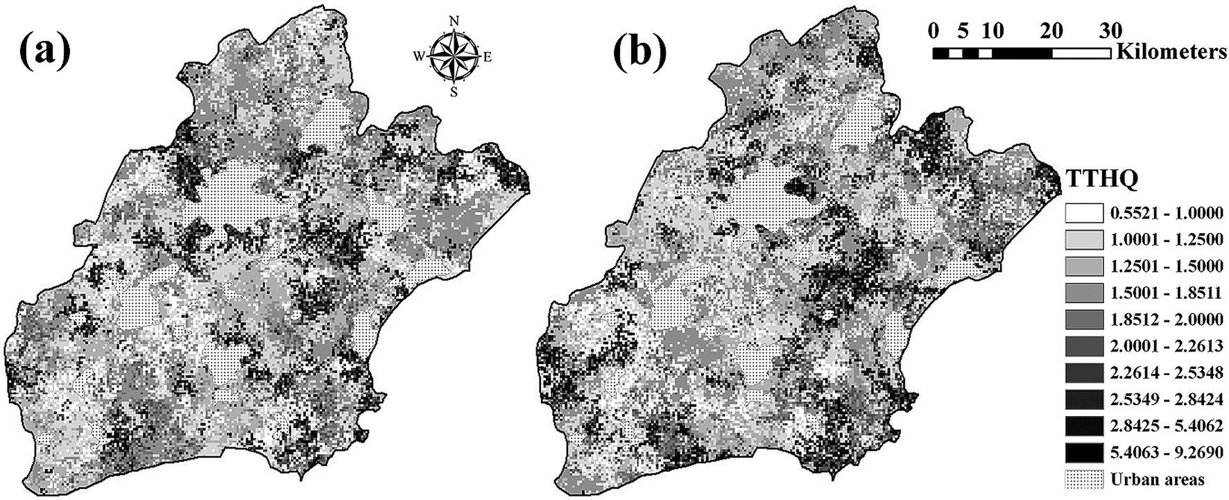 | ||
| Fig. 5 Two randomly selected realizations simulated by SIS for mapping the TTHQ in Jiaxing city: (a) realization 80 and (b) realization 420. | ||
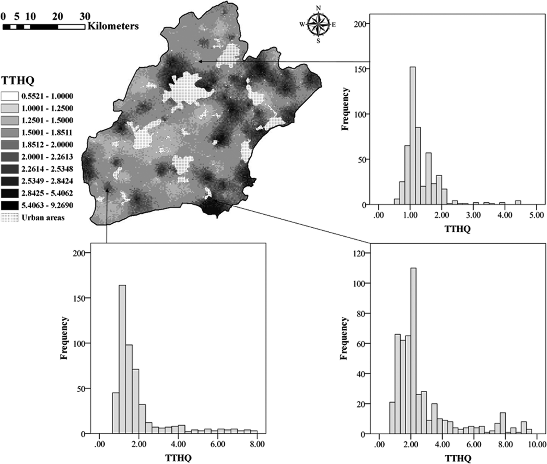 | ||
| Fig. 6 The E-type estimate map of the TTHQ and three histograms corresponding to the simulated values at different sites, which are both estimated from 500 SIS-generated realizations. | ||
Fig. 7 shows the spatial distribution map of different potential human health risk grades (Table 2) based on the E-type estimate map. Although 40 sample points (14% of the total sample points) fall into the safe grade, it is seen that the safe grade in the grade map of the potential health risk is almost negligible. This indicates that the smoothing effect, which commonly occurs in kriged maps, resulted in the overestimation of low values and underestimation of high values;12 thus, a large amount of information was lost in the SIS E-type estimate map. Because the average TTHQ for multiple trace metals (i.e. 1.6954) exceeds the safety level (i.e. 1.0), one can speculate that the E-type estimate may have overestimated the health risk at places where the health risk is actually in the safe grade (i.e. <1.0) because of the overestimation of low values.
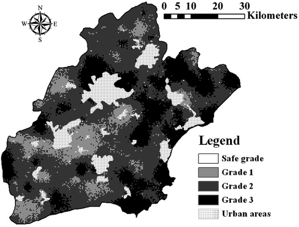 | ||
| Fig. 7 The spatial distribution map of different health risk grades based on the E-type estimate map generated by SIS. | ||
3.4. Uncertainty evaluation of potential human health risk
The conditional variance estimated from a number of simulated realizations reflects the fluctuation of simulated TTHQ values at any unsampled location. Fig. 8 shows that conditional variance values are larger at places with higher TTHQ values (Fig. 8a and b, as well as Fig. 6). This indicates that at places where high TTHQ values are expected, the simulated values have more dramatic fluctuations, and thus larger uncertainty is also intuitively expected. Areas with higher uncertainty in predicted TTHQ, such as the dark patches appearing in the northwest, northeast and southeast parts of the study area (Fig. 8a), are usually considered to be places that require additional sampling. However, for SIS, the magnitude of conditional variance seems also related with the selection of threshold values for ccdf construction. One can see that large conditional variance values mainly occur with those large TTHQ sample values that are above the largest threshold value, i.e. 2.09 (Fig. 8). For this top interval (i.e., >2.09), the corresponding section of ccdf at any unsampled location is obtained through extrapolation usually using a hyperbolic model;12 thus, the simulated TTHQ values in this interval tend to have the largest fluctuation. The conditional variance of simulated TTHQ is zero at any sampling location, because the SIS algorithm assigned the TTHQ sample values into the simulation grid at their corresponding sampling locations.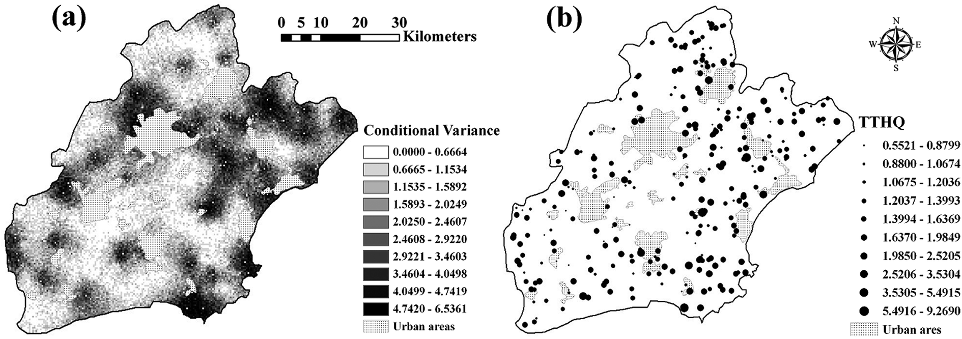 | ||
| Fig. 8 The conditional variance map based on the 500 SIS-generated realizations of TTHQ (a) and the magnitude map of TTHQ at sample locations (b) in Jiaxing city. | ||
Probability maps of the TTHQ for different health risk grades are presented in Fig. 9. One can see that grade 1 has the largest probability values at most places in the study area, and grade 2 and grade 3 also have high probabilities to appear in some spots or subareas. This indicates that the potential human health risk in the study area has reached a point that deserves much attention. However, environmental remediation or control measures on polluted rice grains should be first applied to those places with higher occurrence probabilities of higher risk grades.
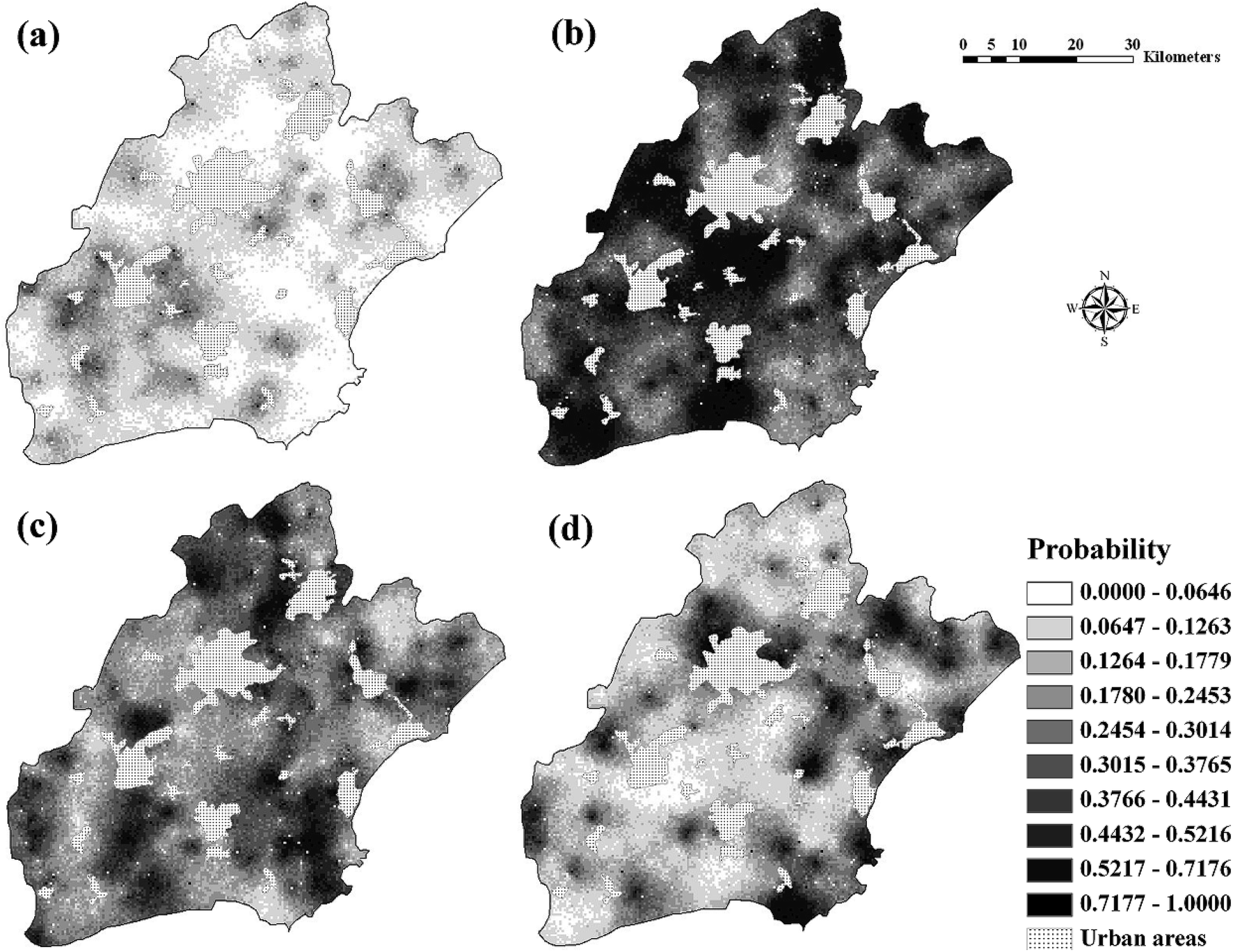 | ||
| Fig. 9 The probability maps of the TTHQ falling into different health risk grades in Jiaxing city: safe grade (a), grade 1 (b), grade 2 (c), and grade 3 (d). | ||
3.5. Other discussions
In this study, we aimed to conduct a spatial evaluation of the quality of the rice grains grown in fields at a regional scale in terms of the potential human health risk of trace metals in rice as an integrative and uniform index. Such a study is centered on the rice growing in fields in the study area and the index is evaluated as an attribute of geo-referenced rice grain samples rather than as an attribute attached with a specific person.Although the current food standards (i.e., the maximum allowance concentrations) for specific trace metals set by governments were often used to evaluate the quality of rice grains, these standards are usually not uniform internationally (i.e., they may be different between different countries, provinces or government departments) and also not integrative (i.e., the cumulative effect of multiple trace metals is not considered). In addition, different trace metals have different toxic effects, which cannot be effectively reflected by metal concentrations. However, the THQ index designed by US EPA6 takes into account the toxic effects of different trace metals, and the TTHQ index further considers the integrative effect of multiple trace metals. The TTHQ index may be used as uniform standard indices for food quality in terms of trace metals and potential human health risks; therefore, we used the TTHQ index in this study.
Because this study was focused on the spatial distribution and uncertainty of the potential human health risk of trace metals in rice growing in fields at a regional scale, all parameters related to humans took assumed data in calculating the THQ and TTHQ indices for each rice grain sample. Other food sources were not taken into account; nevertheless, this does not negate the usefulness of the THQ or TTHQ used as a uniform index to reflect the quality of rice in terms of the health risk of single or multiple trace metals, if it is estimated with the same assumptions and standards. Therefore, it is valuable to know the spatial distribution and uncertainty of the potential human health risk of trace metals in rice in rice-growing fields, which is represented by TTHQ, in a specific region so that high risk areas can be identified and optimal rice growing plan can be made by agricultural planners such as forbidding the high risk areas for agriculture. Apart from soil trace metal itself, there are many other factors that impact the trace metal accumulation in rice grain such as soil pH, soil organic matter content (SOM), cation exchange capacity (CEC), and oxidation–reduction status (Eh).44 Therefore, the question as to why rice grains are polluted in some areas is an interesting topic and deserves further study.
4. Conclusions
Five trace metals (Cd, Cr, Cu, Pb and Zn) in field-sampled rice grains were investigated in Jiaxing city, east China. Although the average concentrations of trace metals in rice are lower than or approximately equal to their respective permissible limits in Chinese National Standards, some rice grain samples still indicate high concentrations of trace metals, which may pose some potential threat to human health. The threshold-exceeding risk probability of five trace metals in rice grains was mapped based on the permissible limits in Chinese National Standards and measured sample data. The results show that hazardous areas mainly occur as several patches around the center of the region.The potential human health risk of these trace metals in local rice grains was assessed using the TTHQ index. The TTHQ quantifies the non-carcinogenic human health risk caused by multiple pollutants. Although the potential health risks from individual trace metals are not noticeable, the aggregate potential health risk index TTHQ of the five trace metals in local rice grains is higher than the safe grade (i.e., 1.0) at most places. This indicates that attention should be focused on the joint potential health risk of multiple trace metals in rice grains. The spatial distribution of the TTHQ index was simulated. The results show that unsafe health risk grades, particularly grade 1, have large probabilities to occur in most areas of the studied region. The method could be used in other cities to predict high risk areas and quantify the corresponding uncertainty.
The spatial assessment of potential human health risks caused by trace metals in local rice grains may provide useful information as an integrative and uniform index to local agricultural planners in spatial decision making for rice planning and environmental management. For example, for those places (i.e., patches of farmland) where high health risk grades are identified, rice may be regarded to be unsafe as food. Thus, agricultural planners may consider not to plant rice in those places in future or to apply some measures to remedy the soils to improve rice quality. Such an integrative and uniform index can be more useful and comparative than the concentrations of trace metals in rice because it takes into account the different toxic effects of different trace metals, and the cumulative effect of multiple metals.
Acknowledgements
This work was supported by the National Natural Science Foundation of China (41401523), the Natural Science Foundation of Jiangsu Province (BK20141055) and the China Postdoctoral Science Foundation Funded Project (2014T70554) and the Special Research Foundation of the Public Natural Resource Management Department from the Ministry of Environmental Protection of China (201409044). We also extend our sincere thanks to two anonymous reviewers for their valuable comments on the manuscript.References
- P. Ünak, F. Y. Lambrecht, F. Z. Biber and S. Darcan, J. Radioanal. Nucl. Chem., 2007, 273, 649–651 CrossRef.
- M. Gopalani, M. Shahare, D. S. Ramteke and S. R. Wate, Bull. Environ. Contam. Toxicol., 2007, 79, 384–387 CrossRef CAS PubMed.
- R. K. Sharma, M. Agrawal and F. Marshall, Ecotoxicol. Environ. Saf., 2007, 66, 258–266 CrossRef CAS PubMed.
- FAO/WHO, List of contaminants and their maximum levels in foods, Codex Alimentarius Commission, Rome, 1st edn, 1984, vol. XVII Search PubMed.
- US EPA, Handbook for non-cancer health effects evaluation, United States Environmental Protection Agency, Washington (DC), 2000 Search PubMed.
- US EPA, Risk Assessment guidance for superfund, human health evaluation manual (part A), United States Environmental Protection Agency, Washington (DC), 1989, vol. I Search PubMed.
- R. L. Hough, N. Breward, S. D. Young, N. M. J. Crout, A. M. Tye, A. M. Moir and I. Thornton, Environ. Health Perspect., 2004, 112, 215–221 CrossRef CAS.
- X. L. Wang, T. Sato, B. S. Xing and S. Tao, Sci. Total Environ., 2005, 350, 28–37 CrossRef CAS PubMed.
- G. M. A. Bermudez, R. Jasan, R. Plá and M. L. Pignata, J. Hazard. Mater., 2011, 193, 264–271 CrossRef CAS PubMed.
- F. E. Fontúrbel, E. Barbieri, C. Herbas, F. L. Barbieri and J. Gardon, Environ. Pollut., 2011, 159, 2870–2875 CrossRef PubMed.
- Q. Li, Y. Chen, H. Fu, Z. Cui, L. Shi, L. Wang and Z. Liu, J. Hazard. Mater., 2012, 227, 148–154 CrossRef PubMed.
- P. Goovaerts, Geostatistics for natural resources evaluation, Oxford University Press, New York, 1997 Search PubMed.
- M. Qu, W. Li and C. Zhang, Ecol. Inform., 2013, 13, 99–105 CrossRef PubMed.
- C. Franco, A. Soares and J. Delgado-Garcia, Characterization of Environmental Hazard Maps of Metal Contamination in Guadiamar River Margins, in GeoENV IV-Geostatistics for Environmental Applications, ed. X. S. Vila, J. Carrera and J. G. Hernández, Springer, Netherlands, 2004, pp. 425–436 Search PubMed.
- C. S. Jang, C. W. Liu, K. H. Lin, F. M. Huang and S. W. Wang, Environ. Sci. Technol., 2006, 40, 1707–1713 CrossRef CAS.
- J. J. Lee, C. S. Jang, C. P. Liang and C. W. Liu, Sci. Total Environ., 2008, 403, 68–79 CrossRef CAS PubMed.
- J. R. Gay and A. Korre, Environ. Pollut., 2006, 142, 227–234 CrossRef CAS PubMed.
- G. M. Zeng, J. Liang, S. Guo, L. Shi, L. Xiang, X. Li and C. Du, Chemosphere, 2009, 77, 368–375 CrossRef CAS PubMed.
- M. Qu, W. Li, C. Zhang, Y. Zhao, B. Huang, W. Sun and W. Hu, Soil Sci. Soc. Am. J., 2013, 77, 2182–2191 CrossRef CAS.
- M. Amini, Sci. Total Environ., 2005, 347, 64–77 CrossRef CAS PubMed.
- M. M. Hassan and P. J. Atkins, J. Environ. Sci. Health, Part A: Toxic/Hazard. Subst. Environ. Eng., 2007, 42, 1719–1728 CrossRef CAS PubMed.
- U. Schnabel, Environ. Manage., 2004, 33, 911–925 CrossRef.
- M. Van Meirvenne and P. Goovaerts, Geoderma, 2001, 102, 75–100 CrossRef CAS.
- H. J. Chu, Y. P. Lin, C. S. Jang and T. K. Chang, Geoderma, 2010, 158, 242–251 CrossRef CAS PubMed.
- N. Diodato and M. Ceccarelli, Ecol. Indic., 2004, 4, 77–187 CrossRef PubMed.
- J. L. Smith, J. J. Halvorson and R. I. Papendick, Soil Sci. Soc. Am. J., 1993, 57, 743–749 CrossRef.
- C. Zhang, L. Wu, Y. Luo and H. Zhang, Environ. Pollut., 2008, 151, 470–476 CrossRef CAS PubMed.
- C. S. Jang, S. K. Chen and L. Ching-Chieh, Hydrol. Processes, 2008, 22, 4477–4489 CrossRef CAS.
- Y. P. Lin, B. Y. Cheng, G. S. Shyu and T. K. Chang, Environ. Pollut., 2010, 158, 235–244 CrossRef CAS PubMed.
- Z. T. Gong, G. L. Zhang and Z. C. Chen, Development of Soil Classification in China, in Soil Classification: A Global Desk Reference, ed. H. Eswaran, T. Rice, R. Ahrens and B. A. Stewart, CRC Press, Boca Raton, London, New York, Washington DC, 2003, pp. 101–125 Search PubMed.
- Agricultural Chemistry Committee of China, Conventional Methods of Soil and Agricultural Chemistry Analysis, Science Press, Beijing, 1983, in Chinese Search PubMed.
- US EPA, Integrated Risk Information System, http://www.epa.gov/iris/subst, 2007.
- Y. Chen, B. Huang, W. Hu, C. W. David, X. Liu and S. Niedermann, Sci. Total Environ., 2014, 470, 1140–1150 CrossRef PubMed.
- Y. Qi, B. Huang, Y. Yang, J. L. Darilek, Y. Zhao, W. Sun and Z. Wang, J. Agro-Environ. Sci., 2010, 29, 659–665 CAS , in Chinese.
- Ministry of Health of China, Maximum Level of Zinc in Foods (GB 13106-91), in Chinese, Standards Press of China, Beijing, 1991 Search PubMed.
- Ministry of Health of China, Maximum Level of Copper in Foods (GB 15199-94), (in Chinese), Standards Press of China, Beijing, 1994 Search PubMed.
- Ministry of Health of China, Maximum Level of Contaminants in Foods (GB 2762-2005), in Chinese, Standards Press of China, Beijing, 2005 Search PubMed.
- F. Y. Zhai, The tracking study of dietary patterns and nutritional status change of Chinese residents. Beijing Science Press, Beijing, 2008, in Chinese Search PubMed.
- W. H. Hallenbeck, Quantitative Risk Assessment for Environmental and Occupational Health. Lewis Publishers, Chelsea, 1993 Search PubMed.
- L. C. Chien, T. C. Hung, K. Y. Choang, C. Y. Yeh, P. J. Meng, M. J. Shieh and B. C. Ha, Sci. Total Environ., 2002, 285, 177–185 CrossRef CAS.
- C. V. Deutsch and A. G. Journel, GSLIB: Geostatistical software library and user's guide, Oxford University Press, New York, 1992 Search PubMed.
- K. W. Juang, Y. S. Chen and D. Y. Lee, Environ. Pollut., 2004, 127, 229–238 CrossRef CAS PubMed.
- J. P. Chilès and P. Delfiner, Geostatistics modeling spatial uncertainty (Wiley Series in Probability and Statistics), Wiley, New York, 1999 Search PubMed.
- M. Qu, W. Li, C. Zhang, B. Huang and Y. Zhao, Soil Sci. Soc. Am. J., 2014, 78, 1765–1774 CrossRef CAS.
| This journal is © The Royal Society of Chemistry 2015 |