The importance of nitrogen limitation in the restoration of Llangorse Lake, Wales, UK
Linda
May
*a,
Bryan M.
Spears
b,
Bernard J.
Dudley
c and
Tristan W.
Hatton-Ellis
d
aCentre for Ecology & Hydrology, Bush Estate, Penicuik, Midlothian, Scotland, UK EH26 0QB. E-mail: lmay@ceh.ac.uk; Fax: +44 (0)131 445 3943; Tel: +44 (0)131 445 8537
bCentre for Ecology & Hydrology, Bush Estate, Penicuik, Midlothian, Scotland, UK EH26 0QB. E-mail: spear@ceh.ac.uk; Fax: +44 (0)131 445 3943; Tel: +44 (0)131 445 8536
cCentre for Ecology & Hydrology, Bush Estate, Penicuik, Midlothian, Scotland, UK EH26 0QB. E-mail: bedu@ceh.ac.uk; Fax: +44 (0)131 445 3943; Tel: +44 (0)131 445 8539
dCountryside Council for Wales, Maes-y-Ffynnon, Ffordd Penrhos, Bangor, Gwynedd, Wales, UK LL57 2BQ. E-mail: t.hatton-ellis@ccw.gov.uk; Fax: +44 (0)1248 385510; Tel: +44 (0)1248 387171
First published on 19th October 2009
Abstract
Llangorse Lake is the largest natural lake in South Wales, UK, and is of European conservation importance. The site has a long history of eutrophication problems and, in recent years, significant efforts have been made to meet water quality restoration targets at this site by reducing the input of phosphorus (P) from external sources. Although the lake has improved substantially in quality since the late 1970s, it is still not meeting its ecological targets. Phosphorus concentrations have remained high and there has been little reduction in algal biomass. Management decisions to reduce P input were originally based on the widely held assumption that shallow lakes are P-limited in summer. However, this study clearly shows that this is not always the case; Llangorse Lake, at least, is strongly nitrogen (N) limited over the summer months. As a result, bio-available P released from the sediments cannot be used by the phytoplankton population. So, it accumulates in the water column, causing very high concentrations to occur in late summer. This puts the lake at very high risk of developing algal blooms when N availability increases, usually in early autumn. The study also found that the hydrology of the lake was strongly affected by sub-surface flow. This suggested that nutrients and water could be delivered to the lake from areas beyond the topographically defined surface water catchment. These findings have widespread implications for the successful management of external inputs to lakes, which currently tends to focus on management of the surface water catchment only. The results are discussed in relation to the restoration and management of nitrogen-limited lakes, and of those that are significantly affected by sub-surface flow.
Environmental impactNutrient enrichment of shallow lakes by agricultural, cultural and industrial inputs from the catchment often causes troublesome, and potentially toxic, algal blooms. As a result, many such lakes are often declared unsafe and are closed to the public in summer. Algal blooms also affect the biodiversity of these systems, restricting the growth of underwater plants by reducing water clarity, and causing fish deaths by deoxygenating the water. Most restoration programmes focus almost exclusively on reducing phosphorus inputs to improve water quality in these lakes. However, this study shows that nitrogen inputs may also need to be reduced if restoration targets are to be met. The results of this study have wide implications for the restoration and management of shallow eutrophic lakes. |
Introduction
The restoration of nutrient enriched, shallow, freshwater lakes is set to dominate applied limnology in the coming years. It is well documented that elevated nutrient inputs from the catchment, resulting from agricultural, cultural, and industrial activity, are the primary cause of this enrichment (eutrophication).1,2 The main impact on the receiving water is usually a dramatic shift from benthic to planktonic production, with associated phytoplankton blooms1 that cause a deterioration of water quality. However, shifts in the macrophyte, diatom and fish communities, increased sedimentation rates, sediment anoxia and growth of filamentous algae are also commonly associated symptoms of eutrophication.Phosphorus is usually assumed to be the main nutrient limiting phytoplankton growth in freshwater lakes.2 This assumption, which is based on large scale multi-lake analyses that show strong relationships between water column total phosphorus (TP) and chlorophyll a concentrations,3–5 is currently being used to drive lake restoration programmes to meet the requirements of the EC Water Framework Directive (WFD).6 As a result, many restoration programmes have focused on reducing point and diffuse sources of P from the catchment.7–9
Although clear evidence exists to validate the TP–chlorophyll a relationship at the meta-scale, other factors may also regulate the accumulation of phytoplankton biomass in freshwater lakes at the site-specific level. These include nitrogen (N) limitation,10 alterations in the community structure, biomass, and grazing intensity of zooplankton (especially as a result of fish stocking11), and light limitation due to high concentrations of humic substances12 and resuspended sediment.13 In addition, lake bed sediments may be significant reservoirs of P and other important nutrients, especially in lakes where the external nutrient loading has been reduced after a long period of enrichment.9,14,15
These processes and their drivers are relatively well understood at the general level. However, at the lake specific level, intensive limnological assessments are required to identify the relative importance of each process. In practice such assessments are extremely rare.16,17 This is due, mainly, to the logistical and financial costs of accurately identifying (i) the main sources of nutrients entering the water column and (ii) the key factors that limit the accumulation of phytoplankton biomass. Also, the relative importance of each process may vary over time, depending on the stage of restoration of the water body. For example, N limitation may become more important when external P loading is reduced, especially in summer when denitrification rates and internal P loading are high.8 This makes it essential to continuously re-assess restoration objectives and progress at any given lake.
Llangorse Lake is an internationally important water body in western Britain that currently has a long-term restoration plan in place. As part of this process, a significant effort has been made to manage the lake more effectively, most notably by reducing or diverting P input from external point sources. However, this has not resulted in the desired improvements in water quality. This paper uses long-term and contemporary monitoring data to explore the reasons for this by (1) assessing long-term variations in water quality parameters within Llangorse Lake in relation to restoration efforts and (2) conducting the first comprehensive assessment of external and internal nutrient sources to the water column. The implications of these results for the future management of the lake are discussed.
Materials and methods
Site description and restoration history
Llangorse Lake (51°55′N; 3°15′W; Fig. 1) is the largest natural eutrophic lake in Wales, UK. It has a surface area of 139 ha18 and a maximum depth of 7.75 m.19 The alkalinity of the lake is 2331–2542 µeq l−1 and the pH ranges from 7.88 to 8.08.18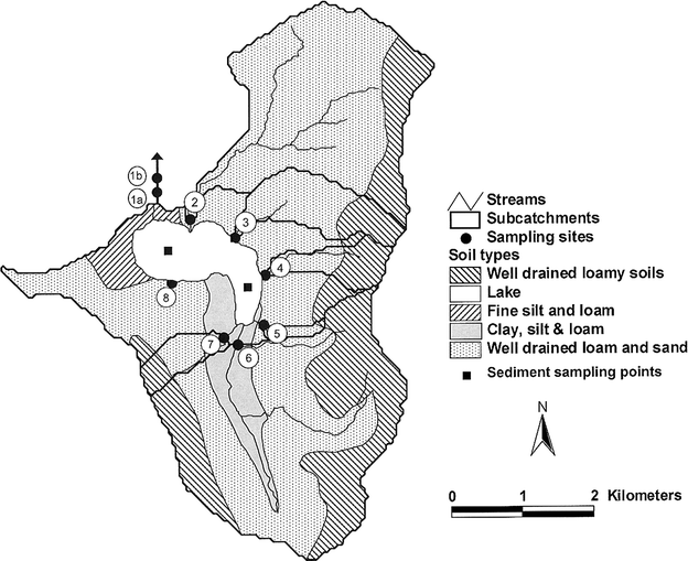 | ||
| Fig. 1 Map showing subcatchment boundaries, soil types, and the location of flow gauges and sampling sites within the catchment of Llangorse Lake, Wales, UK. Sampling sites on the outflow are those used in this study (1a) and previous studies (1b). | ||
The catchment of the lake covers an area of about 2200 ha and is predominantly under agricultural use for sheep and cattle grazing, especially in the low lying areas around the shores of the lake. Here, most of the land is improved pasture.20 There are also small areas of unimproved pasture, moorland, woodland and arable land scattered across the catchment.
It is estimated that about 1500 people live within the catchment, about 500 of whom are served by the sewage treatment works (STWs) at Llangorse and Bwlch. The remainder depend upon septic tank systems for the treatment of their domestic sewage and wastewater.
The ecological and conservation importance of the lake has been recognised since 1954, when it was designated as a site of special scientific interest (SSSI) under UK legislation. In 1995, the lake was also designated as a special area of conservation (SAC) under the EU Habitats and Species Directive for its importance as a natural eutrophic lake with Magnopotamion or Hydrocharition type vegetation.21
The lake is relatively well studied, with some aquatic plant records dating back to the late 19th century. At present, the lake supports a wide range of aquatic plants, with 20 hydrophyte species recorded in 2003.21 Eight species of Potamogeton have been recorded from the lake, as well as the rare hybrid yellow water lily Nuphar × spenneriana, three different charophytes and a diverse marginal community.19 Palaeolimnological evidence suggests that the lake formerly supported Nitella sp. and Potamogeton praelongus,22 although neither has been recorded there during a field survey.
In addition to aquatic macrophytes, the lake provides an important habitat for a wide range of invertebrates, including the variable damselfly, Coenagrion pulchellum, and the medicinal leech, Hirudo medicinalis. The lake also supports many breeding and over-wintering wetland birds.23 It also provides socio-economic benefits to the local community through its use as a recreational site for coarse fishing and water sports.20
In the 1970s, effluent from the STWs at Bwlch and Llangorse discharged nutrient laden waste into the lake. This caused a dramatic increase in soluble reactive phosphorus (PO4-P) levels in the water column, which routinely peaked at about 600 µg L−1 during late summer/autumn.24 This elevated nutrient input caused a steady decline in the biodiversity and biomass of the macrophyte community and an increase in phytoplankton biomass. By 1978, the only submerged macrophyte that remained was Zannichellia palustris, a species that is very tolerant of eutrophication.25 During this period, algal blooms were dominated by cyanobacteria, notably Microcystis and Anabaena, which formed more than 96% of the total phytoplankton biomass.24
As part of a restoration plan for the lake, a P budget was drawn up by the Welsh Water Authority in the 1970s.26 This suggested that the TP load to the lake was 1.0–1.5 tonnes y−1, of which 0.4–0.6 tonnes y−1 came from the STWs mentioned above. As part of the lake restoration plan, the effluent from Llangorse STWs was diverted away from the lake in 1981 and that from Bwlch STWs in 1992.25
The Countryside Council for Wales (CCW) is responsible for setting conservation objectives for Llangorse Lake SSSI and SAC, which are set out in the core management plan for the lake.27 These conservation objectives are a requirement of the 1992 Habitats Directive (92/43/EEC), which aims to maintain or, where appropriate, restore the ‘favourable conservation status’ of habitats and species features for which SACs are designated. In broad terms, ‘favourable conservation status’ means that a feature is in satisfactory condition and that all of the things needed to keep it that way are in place for the foreseeable future. CCW and other UK conservation agencies use the concept of favourable conservation status as a practical and legally robust basis for setting conservation objectives for Natura 2000 sites. Conservation objectives for Llangorse Lake include the re-establishment of a characteristic macrophyte community, a maximum annual mean TP concentration of 35 µg L−1, and a minimum dissolved oxygen (DO) concentration of at least 5 mg L−1 throughout the water column.27
Diversion of the two STWs outfalls had a positive effect on the lake. Annual mean in-lake TP concentrations fell from about 160 µg L−1 in the mid-1980s to about 120 µg L−1 by the mid-1990s (Fig. 2). A significant decline in cyanobacterial blooms was also recorded, with the phytoplankton becoming increasingly dominated by Chlorophyta and diatoms;24 a more diverse macrophyte community also reappeared.18,21,28 However, in spite of these improvements, these restoration measures were only partially successful. The submerged aquatic plant community continued to show signs of instability28 and has continued to be dominated by species that are characteristic of strongly eutrophic water bodies.25,28 Also, the 20% reduction in open water TP concentration that was achieved was insufficient to enable the SAC target concentration for TP (i.e. an annual mean concentration of 35 µg L−1) to be met.29 These initial results suggested that significant sources of P had not been accounted for in the initial budget.
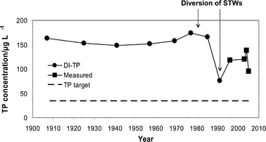 | ||
| Fig. 2 Long-term variation in annual mean in-lake total phosphorus (TP) concentrations in Llangorse Lake, 1907–2005. TP data comprise diatom inferred TP (DI-TP) estimates (●) for 1907–199138 and measured annual average TP concentrations for 1995–2005 (■).39 The broken line represents the special area of conservation target TP concentration of 35 µg L−1 for the lake. Arrows indicate when effluent from the sewage treatment works (STWs) was diverted away from the lake. | ||
In recent years, a site condition assessment21 undertaken by CCW found the lake to be in unfavourable condition; it was continuing to show symptoms of elevated nutrient levels (including TP and PO4-P) and was dominated by taxa with preferences for high nutrient concentrations, such as Ceratophyllum demersum. In addition, palaeolimnological evidence showed a highly significant degree of floristic change between ca. 1830 and 1996, which was also indicative of eutrophication.30 It was suggested that the continuing eutrophication problems were probably a result of nutrient inputs from diffuse sources within the catchment, some of which were thought to be associated with increased sediment loads as a result of agricultural intensification on local farms.31
Historical variations in nutrient concentrations in the inflow and outflow
Variations in nutrient concentrations in the main inflow since 1996 were explored using historical data provided by the Environment Agency (EA). These water chemistry values had been determined using standard analytical methods. As individual years may not fully represent the overall situation due to inter-annual variation, average conditions over 2 × 3 year periods, namely 1996–1999 (past) and 2004–2007 (present/recent), were compared.Monthly average values for each of the time periods outlined above were calculated for NO3-N and PO4-P concentrations. To take account of gaps in the data, monthly average values were derived only where at least two values from separate years were available.
The comparative approach described above was also used for the outflow determinants. Here, the EA sampling point was about 100 m further downstream than that used in the present study (Fig. 1). Monthly average values for each period were calculated for TP, PO4-P, TN and NO3-N concentrations, and for the TN : TP ratio. Again, the monthly values represented averages of at least two values from separate years.
Annual average TP concentrations were estimated using available data and compared to targets set for a shallow, high alkalinity lakes to meet the requirements of the WFD.32 Throughout this study, outflow data have been used as a proxy for in-lake conditions.
Estimating the nutrient input from the catchment for 2006/2007
| Site name | Location | Type | |
|---|---|---|---|
| Easting | Northing | ||
| 1 Afon Llynfi (outflow) | 312![[thin space (1/6-em)]](https://www.rsc.org/images/entities/char_2009.gif) 565 565 |
227129 |
Outflow |
| 2 Lower Pendre Farm | 313083 |
227050 |
Inflow |
| 3 Tynewydd Farm | 313714 |
226799 |
Inflow |
| 4 Cathedine Fawr Farm | 314137 |
226274 |
Inflow |
| 5 Lower Cathedine Farm | 314107 |
225581 |
Inflow |
| 6 Afon Llynfi (inflow) | 313749 |
225313 |
Inflow |
| 7 Neuadd Farm | 313551 |
225407 |
Inflow |
| 8 National Trust Woodland | 312821 |
226170 |
Inflow |
| Sediment 1 | 313886 |
226036 |
Sediment |
| Sediment 2 | 312948 |
226628 |
Sediment |
Water and flow sampling was conducted at fortnightly intervals for one year, starting on 10/10/06. On several occasions it was either impossible or unsafe to sample Sites 1 and 7 due to flooding. The dates on which these sites were not sampled were 5/12/06, 19/12/06, 2/1/07 and 13/3/07.
Because the gauging board at Site 2 (close to the town of Llangorse) disappeared at an early stage of the project, flows at this site were estimated from a regression equation relating measured flows at this site to those of the site that was most closely correlated with, i.e. Site 6. The regression equation used was: Q2 = 0.3053 × Q6 − 0.0167 (r2 = 0.97), where Q is the rate of flow (m3 s−1) at Sites 2 and 6. The annual hydraulic load was determined as the sum of the measured inflows. These values were combined with the estimated lake volume of 3.6 × 10⁶ m3 (ref. 26) to determine the flushing rate of the lake.
Rainfall data for the period 21/6/06 to 11/6/07 were made available to the project by Forest Research. The data comprised readings taken at 10 min intervals by a tipping bucket rain gauge situated at Abergavenny (51°51′N; 3°00′W). There was a period of missing data between 19/7/06 and 4/10/06 and no data were available beyond 11/6/07 due to vandalism of the rain gauge and theft of its associated datalogger. For this reason, annual rainfall for this area was estimated over the 1 year period for which data were available rather than the 1 year period that corresponded to sample collection and flow monitoring in this project.33 This is likely to have underestimated the rainfall over the study period, which spanned a period of exceptionally heavy rainfall and severe flooding in late July 2007.
Estimates of hydrologically effective rainfall (HER) were derived from the flow monitoring data for each inflow to the lake by dividing the estimated annual flow in each stream by the area of the surface water catchment upstream of each gauging site. A corresponding value was also estimated from the annual rainfall over the catchment minus the long-term average annual evapo-transpiration rate for the Llangorse area (i.e. 600 mm y−1). The latter calculation would be expected to correspond to the measured downstream flow in catchments whose hydrology is dominated by surface runoff. However, this does not hold for catchments where there is significant sub-surface flow.
A single, average, annual export coefficient, expressed as kg ha−1, was determined for the loss of TP, PO4-P and NO3-N from each subcatchment by dividing the annual export of each nutrient fraction by the surface area of the upstream water catchment.
TP was determined on unfiltered water using the molybdate-blue colorimetric method following a sulfuric acid–persulfate digestion. Soluble reactive P (PO4-P) was determined on filtered water using the same colorimetric analysis with no persulfate digestion.34
Filtered water samples were analysed for nitrate on a SEAL AQ2 analyser (SEAL Analytical Limited, Burgess Hill, West Sussex, UK) using the sulfanilamide–NEDD (N-1-naphthyl ethyenediamine dihydrochloride) reaction (Centre for Ecology and Hydrology, Lancaster Laboratory, ISO 17025).
Instantaneous nutrient loads to the lake for each inflow (g d−1) were estimated at the time of sampling by multiplying the measured nutrient concentrations (g L−1) by the corresponding flows (L d−1). These 26 values were then averaged to give a mean daily load to the lake, which was then multiplied by 365 to provide an estimated annual load to the lake.
Results
Historical variations in water quality in the main inflow
Historical comparisons of average monthly concentrations of NO3-N and PO4-P in the main inflow for the periods 1996–1999 and 2004–2007 are shown in Fig. 3a and b. The results show that average monthly NO3-N concentrations have decreased by about 25% in recent years, with the greatest change being in autumn and winter. PO4-P concentrations also fell in autumn and winter over the same period, but remained at the same level during spring and summer. | ||
| Fig. 3 Average monthly (a) NO3-N concentrations and (b) PO4-P concentrations in the main inflow to the lake over the periods 1996–1999 (solid line) and 2004–2007 (broken line). | ||
Historical variations in water quality in the outflow
Average monthly concentrations of NO3-N in the outflow for the periods 1996–1999 and 2004–2007 are shown in Fig. 4a. The seasonal trend in NO3-N was similar over both periods, with concentrations being higher in winter and lower in summer. Overall, there was a reduction in NO3-N concentrations in autumn, winter and early summer between 1996–1999 and 2004–2007, while NO3-N concentrations fell to almost zero during June–August over both periods. | ||
| Fig. 4 Average monthly (a) NO3-N and (b) PO4-P concentrations in the lake outflow over the periods 1996–1999 (full line) and 2004–2007 (dashed line). | ||
Average monthly concentrations of PO4-P in the outflow are compared for the same two periods in Fig. 4b. In contrast to NO3-N, PO4-P concentrations were relatively low from winter to early summer and then increased markedly during late summer/early autumn. In general, although following a similar seasonal pattern, PO4-P concentrations in the lake have reduced in recent years. This reduction has not been sufficient to result in the lake achieving its conservation objective32 (Fig. 2).
Changes in the ratio between total N and total P concentrations (TN : TP) in the outflow for 1996–1999 and 2004–2007 are shown in Fig. 5. As the outflow sampling point is just downstream of the lake, these data can be taken as a surrogate for lake water quality. As such, they suggest a seasonal switch in nutrient limitation of phytoplankton growth over the year, with the lake being primarily P-limited from late autumn until late spring, and N-limited from early summer to early autumn.
 | ||
| Fig. 5 Average monthly TN : TP ratio in the lake outflow over the periods 1996–1999 (solid line) and 2004–2007 (broken line). | ||
Nutrient inputs to the lake, 2006/2007
| Site | Subcatchment area | Estimated annual hydraulic load | Runoff/mm | ||
|---|---|---|---|---|---|
| km2 | % | m3 | % of total | ||
| 2 (Nant Cwy) | 5.81 | 25.7 | 4391605 |
18 | 760 |
| 3 (Hoel Ddu) | 1.39 | 6.16 | 2195064 |
9 | 1580 |
| 4 (Cwm) | 0.71 | 3.14 | 701604 |
3 | 990 |
| 5 | 0.15 | 0.65 | Very low | 0 | 0 |
| 6 (Afon Llynfi) | 8.07 | 35.74 | 16087887 |
67 | 1990 |
| 7 (Cathedine) | 0.54 | 2.38 | 639562 |
3 | 1190 |
| 8 | Topography too flat | Very low | 0 | 0 | |
| Ungauged area | 5.93 | 26.23 | Unknown | 0 | 0 |
| Total | 22.59 | 100 | 24015722 |
100 | 1060 |
Further evidence of interactions with groundwater could be seen when runoff values (mm) for each stream were estimated by dividing the measured annual discharge in each stream by the area of topographically defined subcatchment upstream of each monitoring point. In subcatchments dominated by surface runoff, these values would be expected to be similar to the hydrologically effective rainfall (HER) for the area, as calculated on the basis of rainfall minus evaporation (i.e. 550 mm y−1). However, many of the runoff values shown in Table 2 are either much larger (Sites 2, 3, 4, 6 and 7) or much smaller (Sites 5 and 8) than this value, suggesting gains from or losses to sub-surface flow, respectively.
Rates of flow in the outflow were difficult to measure directly because of relatively frequent high flows that occurred in this area, so the sum of the inflows was used to estimate water retention time for the lake. Table 2 suggests that this value was about 24015722 m3 of water over 1 year period of study. When combined with the estimated volume of the lake, i.e. 3.6 × 10⁶ m3,26 this gives a water retention time for the lake during 2006/2007 of about 55 days. This value is somewhat lower than the previous estimate of 70 days,35 suggesting that the lake flushes faster than was previously thought.
| Site | TP | PO4-P | NO3-N | ||||||
|---|---|---|---|---|---|---|---|---|---|
| Load/kg y−1 | Load (%) | Export coefficient/kg ha−1 y−1 | Load /kg y−1 | Load (%) | Export coefficient/kg ha−1 y−1 | Load/kg y−1 | Load (%) | Export coefficient/kg ha−1 y−1 | |
| Site 2 | 616 | 29 | 1.06 | 477 | 34 | 0.82 | 22326 |
30 | 38.45 |
| Site 3 | 230 | 11 | 1.65 | 187 | 13 | 1.34 | 9849 | 13 | 70.79 |
| Site 4 | 26 | 1 | 0.37 | 14 | 1 | 0.19 | 2277 | 3 | 32.13 |
| Site 6 | 1166 | 56 | 1.44 | 711 | 50 | 0.88 | 38438 |
52 | 47.61 |
| Site 7 | 60 | 3 | 1.10 | 35 | 2 | 0.65 | 1148 | 2 | 21.31 |
| Total | 2098 | 100 | 1423 | 100 | 74038 |
100 | |||
In total, the measured annual loads to the lake from the catchment were 2.1 tonnes of TP, 1.4 tonnes of PO4-P and 74 tonnes of NO3-N. These values equate to areal loadings for the lake of 1.5 g P m−2 of TP, 1 g P m−2 of PO4-P and 53 g N m−2 of NO3-N. In general, NO3-N loads were highest in winter and lowest in spring, while TP and PO4-P loads were highest in summer, with the exception of a single peak in winter 2006.
 | ||
| Fig. 6 NO3-N (triangles) and PO4-P (circles) concentrations in the outflow from Llangorse Lake during 2006/2007, showing the build up of PO4-P in the water when N limits phytoplankton growth over the summer period. | ||
Phosphorus content of sediments
The TP content of the lake sediments ranged from 0.6 mg P g−1 dw to 1.7 mg P g−1 dw, with some variation across sites and with depth (Fig. 7). Phosphorus concentration peaked at around 3 cm depth at both sites (except Site 2 in winter) and, in general, TP concentrations decreased with increasing depth below 3 cm. Little seasonal variation was observed in the sediment TP profiles at either of the sampling sites.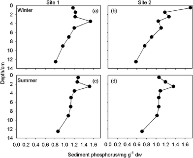 | ||
| Fig. 7 Average concentrations of total phosphorus (TP) in the sediments of Llangorse Lake, expressed as mg P per gram dry weight of sediment on 16/1/2007 (a, b) and 19/7/2007 (c, d). | ||
If the results given above are extrapolated across the entire lake area, it can be concluded that the top 3 cm of sediment contain more than 12 tonnes of TP in total. Only about 0.5 tonnes (∼4%) of this would need to be released to result in an average water column TP concentration of 130 µg L−1. So, an accumulation of P in the lake sediments of this magnitude poses a great risk to water quality at this site.
Discussion
Lake responses to historical catchment management
The study found that NO3-N concentrations in the main inflow to Llangorse Lake had decreased by about 1 mg L−1 in 2004–2007 in comparison with 1996–1999, and that PO4-P concentrations in 2004–2007 were lower in both winter and summer than in 1996–1999. Both of these observations suggest that there have been changes in land use within the catchment, because inputs from the sewage treatment works (STWs) or lake sediments could not have contributed to these values. This is because effluent from both of the STWs had been redirected away from the catchment before 1996, and there are no other point sources of nutrients within the catchment, and nutrient releases from lake sediments are not included in these values.When all of the outflow chemistry data are considered together, and an assumption is made that these observations represent in-lake conditions, inferences can be made about to the functioning of the lake. The data suggest that PO4-P levels are high over the winter period and that these begin to decline in spring as soluble P is incorporated into increasing phytoplankton biomass. However, by early May, nitrate levels in the lake fall to very low levels and, from then onwards, phytoplankton growth appears to be controlled by N limitation. This prevents the algae using the P that enters the lake from the inflow streams or is released from the sediments. As a result, P (especially PO4-P) accumulates in the water column. By the end of the summer, PO4-P concentrations are higher than 130 µg L−1 and TP concentrations more than 150 µg L−1. These data suggest that internal P loading from the sediments is high in summer, although it appears to have decreased in recent years.
Published literature concerning the eutrophication and recovery of Llangorse Lake focuses on P, with very little attention being paid to the role of N in the eutrophication or recovery process. This is probably for historical reasons, because it was (and, in many cases, still is) widely believed that P is the key limiting nutrient in shallow eutrophic lakes and that water quality can be restored by limiting the availability of this nutrient. This study has shown that this does not apply to Llangorse Lake, where algal productivity is actually N-limited rather than P-limited for most of the summer. The main message from this part of the study is that water quality in Llangorse Lake is determined by a delicate balance between P and N availability throughout the year and, especially, in summer. So, it is important to consider both of these nutrients when developing a catchment management plan for this lake.36
Re-assessment of external nutrient loading and implications for recovery
The nutrient load to Llangorse Lake from its catchment is very high when compared to the indicative loadings of P and N for shallow eutrophic lakes.5 It has been suggested that lakes with a mean depth of up to 5 m will become increasingly eutrophic above an areal loading of 0.13 g P m−2 y−1 and 2 g N m−2 y−1.5 These values were found to be approximately 1.5 g P m−2 y−1 and 53 g N m−2 y−1 for Llangorse Lake during 2006/2007, i.e. about 10 and 25 times greater, respectively, than these indicative loadings.Most of the P and N loads were found to be entering the lake in streams that drained to monitoring Sites 2 and 6. Together, these inflows accounted for 85% of the annual TP load and 82% of the annual NO3-N load to the lake. It was concluded that any attempts to significantly reduce the loads of these nutrients to the lake would need to be targeted at sources of nutrient inputs to these streams.
The hydrology of the Llangorse catchment appears to be very complex and strongly affected by sub-surface flow. This is best demonstrated at Site 6, where stream flow per unit area of upstream catchment was estimated to be 1990 mm y−1 (Table 2), while the hydrologically effective rainfall for this area is only 600 mm y−1. This suggests that there is considerable sub-surface flow in this area, which seems to resurface near Site 6 and contribute to overland flow because of the accumulation of less porous clay, silt and loam along the river corridor at this point (Fig. 1). This is a feature of this subcatchment, alone; it is not seen in any of the other subcatchments.
The fact that many of the smaller streams around the catchment are fed by springs37 is also evidence that there is sub-surface water flow in this area. So, it can be concluded that many of the streams that flow into the lake may have significant inputs from sub-surface flow, in terms of their hydrology and chemistry, and that this sub-surface flow may enter the drainage system from an area beyond the boundary of the surface water catchment. This could have serious implications for catchment management planning aimed at reducing the nutrient loads to the lake. It is possible, for example, that some of the nutrient load from Bwlch STWs, which was diverted away from the surface water catchment, may still be making its way into the lake via a sub-surface flow route. As many of these streams dry out in summer, it has not been possible to confirm this by measuring nutrient concentrations under base flow conditions.
Some of the inflow streams showed evidence of occasional point source pollution. This was especially true of Site 2 which, during the heavy storms of July 2007, carried more than 7 kg of P to the lake in a single day compared to its more usual 1–2 kg. This was thought to have been linked to storm overflow from the Llangorse STWs. There was also some evidence of point source pollution occurring in some of the smaller streams during wet conditions, especially at Site 3. The causes of these pollution events are unclear but, given the land use within the catchment, it is likely that these are associated with rainfall driven discharges from slurry tanks, farm ponds or septic tanks. This indicates a need, at least in some places, to control point sources of pollution that occasionally leak or overflow during heavy rainfall events.
Most nutrient transport within the catchment seems to be associated with diffuse sources, such as agriculture, and with widely dispersed, largely unregulated site-based sewage treatment facilities, such as septic tanks. This is true even of the increased P loading ‘event’ that was triggered by heavy rainfall in early December 2006. Although this brought more than 20 kg of P into the lake in a single day, the event was not confined to a single subcatchment. This sudden increase in P load occurred in several streams across the catchment, i.e. Sites 2, 3 and 6, simultaneously. It should also be noted that this sudden increase in P transport across the catchment was not associated with an increase in nitrate loads in all of these streams. At Sites 2 and 6, both P and nitrate loads increased but, at Site 3, only P loads increased. As nitrate is mainly associated with land based sources rather than sewage sources, and the increased P load at this site comprised mainly (84%) PO4-P, this tended to indicate a sewage-related source at Site 3.
The sediment TP concentrations in Llangorse Lake are modest by comparison with other lakes. Sediment TP concentrations in the upper 0–15 cm of lake sediments have been used to estimate lake recovery time following reduction of external P loading.9 At concentrations of less than 1 mg TP g−1 dw, internal loading is expected to be negligible with moderate summer sediment-P release events. At concentrations between 1 mg TP g−1 dw and 2.5 mg TP g−1 dw, net annual sediment-P release will be high, initially, with recovery expected within a 5 year period; high summer P release events would be expected to occur over the recovery period, with these events being affected by pH, dissolved oxygen and microbial activity. At concentrations in excess of 2.5 mg TP g−1 dw, net annual sediment-P release will occur for more than 5 years; in this situation, sediment-P release is expected to occur all year round and will be greatly influenced by pH, dissolved oxygen and microbial activity. At present, Llangorse Lake appears to be close to the boundary of the first and second classification. However, it should be noted that these estimated recovery times only apply once the external loading has been reduced sufficiently to promote this level of recovery.
Conclusions
The results of this study have wide implications for the restoration and management of shallow eutrophic lakes. Firstly, it is clear that it should not be assumed that shallow lakes are P-limited, unless there is clear evidence from site-specific monitoring data that this is the case. This is an important issue because restoration efforts focused specifically on reducing P inputs to N-limited lakes will not reduce phytoplankton biomass until P levels have fallen below growth limiting concentrations. In the meantime, while P concentrations remain high, the lake will be at high risk of developing serious algal blooms if N inputs increase. For this reason, both P and N inputs need to be controlled during the restoration of N-limited shallow lakes. Secondly, this study has also shown that nutrients may be delivered to lakes from areas beyond the topographically defined surface water catchment if the catchment hydrology is subject to sub-surface flow. In such cases, nutrient laden runoff and point source discharges may need to be controlled in areas outside the traditional surface water catchment for restoration to be effective. This issue needs to be considered when developing catchment management plans.Acknowledgements
We are grateful to the following people for providing access to the field sampling sites: Mr and Mrs Tunnicliffe, Mr Jones, Mr Morgan, Mr Evans, Mr Davies, Mr Jones, Mr Gervis and The National Trust. We also thank staff at Forest Enterprise (especially Tony Price) who collected water samples, gauged inflows and provided rainfall data. Our thanks also to David Morris, of the Centre for Ecology and Hydrology (CEH) who derived subcatchment boundaries, the Environment Agency who supplied historical data, and to Clive Woods of CEH who analysed the water samples for nitrate content. Graham Motley and Stuart Reid at Countryside Council for Wales (CCW) provided historical and management information. This research was funded by the Natural Environment Research Council and CCW.References
- Ecology of Shallow Lakes, Kluwer Academic Press, London, UK, 2001 Search PubMed.
- D. W. Schindler, Science, 1977, 195, 260–262 CrossRef CAS.
- P. J. Dillon and F. H. Rigler, J. Fish. Res. Board Can., 1974, 31, 1771–1778 Search PubMed.
- G. Phillips, O.-P. Pietilainen, L. Carvalho, A. Solimini, A. Lyche-Solheim and A. C. Cardosa, Aquat. Ecol., 2008, 42, 213–226 CrossRef CAS.
- Water Management Research; Scientific Fundamentals of the Eutrophication of Lakes and Flowing Waters, with Particular Reference to Nitrogen and Phosphorus as factors in Eutrophication, OECD, Paris, Technical Report DAS/CSI/68.27, 1968 Search PubMed.
- Council of the European Communities, Directive 2000/60/EC, 2000.
- Lake and Reservoir Restoration, Butterworth Publishers, Stoneham, MA, USA, 1986 Search PubMed.
- E. Jeppesen, M. Søndergaard, J. P. Jensen, K. Havens, O. Anneville, L. Carvalho, M. F. Coveney, R. Deneke, M. T. Dokulil, B. Foy, D. Gerdeaux, S. E. Hampton, S. Hilt, K. Kangur, J. Kohler, E. H. H. R. Lammens, T. L. Lauridsen, M. Manca, R. Miracle, B. Moss, P. Noges, G. Persson, G. Phillips, R. Portielje, S. Romo, C. L. Schelske, D. Straile, I. Tatrai, E. Willen and M. Winder, Freshwater Biol., 2005, 50, 1747–1771 CrossRef CAS.
- Lake Restoration by Reduction of Nutrient Loading, Academia Verlag, Richarz, Germany, 1989 Search PubMed.
- S. J. Guildford and B. Hecky, Limnol. Oceanogr., 2000, 45, 1213–1223 CAS.
- R. D. Gulati, Hydrobiologia, 1990, 200/201, 99–118 CrossRef.
- C. E. Williamson, D. P. Morris, M. L. Pace and O. G. Olson, Limnol. Oceanogr., 1999, 44, 795–803 CAS.
- J. Bloesch, Hydrobiologia, 1994, 284, 13–18 CrossRef.
- M. Søndergaard, J. P. Jensen and E. Jeppesen, Sci. World, 2001, 1, 427–442 Search PubMed.
- B. M. Spears, L. Carvalho, R. Perkins and D. M. Paterson, Water Res., 2008, 42, 977–986 CrossRef CAS.
- A. E. Bailey-Watts and A. Kirika, Hydrobiologia, 1999, 403, 135–151 CrossRef CAS.
- The Ecology of Bassenthwaite Lake (English Lake District), Freshwater Forum, 25, Freshwater Biological Association, Ambleside, 2006 Search PubMed.
- C. A. Duigan, S. Reid, D. T. Monteith, H. Bennion, J. M. Seda and J. Hutchinson, Aquat. Conserv. Mar. Freshwater Ecosyst., 1999, 9, 329–341 Search PubMed.
- B. A. Cragg, J. C. Fry, Z. Bacchus and S. S. Thurley, Aquat. Bot., 1980, 8, 187–96 CrossRef.
- J. Dickinson and R. Teeuw, Aquat. Conserv. Mar. Freshwater Ecosyst., 1999, 9, 411–423 Search PubMed.
- A. Burgess, B. Goldsmith and T. Hatton-Ellis, CCW Contract Science Report, 2006, No. 705 Search PubMed.
- H. Bennion, T. Davidson, G. Simpson, N. Solovieva, N. Rose, S. Theophile, H. Yang, N. J. Anderson, S. Brooks and S. Peglar, SNIFFER Report, 2004, WFD08 Search PubMed.
- G. C. Cundale, Nature in Wales, 1980, 17, 71–79 Search PubMed.
- K. Benson-Evans, R. Antoine and S. Antoine, Aquat. Conserv. Mar. Freshwater Ecosyst., 1999, 9, 425–439 Search PubMed.
- P. M. Wade, Aquat. Conserv. Mar. Freshwater Ecosyst., 1999, 9, 441–60 Search PubMed.
- C. Turner, M. Brooker and M. Owens, Llyn Syfaddan-Llangorse Lake. A Brief Review of Scientific and Recreational Investigations, together with Recommendations for Future Studies, Welsh Water Authority Report, 1981 Search PubMed.
- Countryside Council for Wales, Core Management Plan (Including Conservation Objectives) for Llangorse Lake/Llyn Syfaddan Site of Special Scientific Interest (SSSI)/Special Area of Conservation (SAC), Countryside Council for Wales, Abergavenny, 2008 Search PubMed.
- C. Duigan, W. Kovach and M. Palmer, A Revised Classification of British Lakes, Joint Nature Conservation Committee Report, Peterborough, 2006 Search PubMed.
- Joint Nature Conservation Committee (JNCC), Common Standards Monitoring Guidance for Standing Water, JNCC Report, Peterborough, 2005 Search PubMed.
- Identification of reference lakes and evaluation of palaeoecological approaches to define reference conditions for the UK (England, Wales, Scotland and Northern Ireland) ecotypes, Scottish and Northern Irish Forum for Environmental Research (SNIFFER) Research Report WFD08, ed. H. Bennion, Edinburgh, 2004.
- F. M. Chambers, Aquat. Conserv. Mar. Freshwater Ecosyst., 1999, 9, 343–359 Search PubMed.
- UK Technical Advisory Group (UKTAG), UK Environmental Standards and Conditions (Phase 2). UKTAG Report on the Water Framework Directive, No. SR1–2007, 2007 Search PubMed.
- Hydrological Review, 2005, http://www.nwl.ac.uk/ih/nrfa/yb/yb2005/ Search PubMed.
- Limnological Analyses, Springer-Verlag, New York, USA, 2000 Search PubMed.
- D. T. Monteith, Integrated Classification and Assessment of Lakes: Phase III—Final Report. CCW Science Report No. 167, Countryside Council for Wales, Bangor, 1996 Search PubMed.
- P. Haygarth, P. Johnes, D. Butterfield, R. Foy and P. Withers, Land Use for Achieving ‘Good Ecological Status’ of Waterbodies in England and Wales: A Theoretical Exploration for Nitrogen, Defra Report, UK, 2003 Search PubMed.
- R. Jones and K. Benson-Evans, Field Studies, 1974, 4, 61–75 Search PubMed.
- H. Bennion and P. Appleby, Aquat. Conserv. Mar. Freshwater Ecosyst., 1999, 9, 361–375 Search PubMed.
- Special Areas of Conservation (SAC), Special Areas of Conservation: Site Condition Summary Report for Llangorse Lake, SAC Report, 2005 Search PubMed.
| This journal is © The Royal Society of Chemistry 2010 |