Multi-objective, decision-based assessment of a water quality monitoring network in a river system
S. K.
Ning
and
Ni-Bin
Chang
*
Department of Environmental Engineering, National Cheng-Kung University, Tainan, Taiwan, China. E-mail: a1211@mail.ncku.edu.tw; Fax: 886-6-2342357; Tel: 886-6-2342357
First published on 29th November 2001
Abstract
Water quality monitoring network design has historically tended to use experience, intuition and subjective judgement in locating monitoring stations. Better design procedures to optimize monitoring systems need to simultaneously identify significant planning objectives and consider a number of social, economic and environmental constraints. The consideration of multiple objectives may require further decision analysis to determine the preference weights associated with the objectives to aid in the decision-making process. This may require the application of an optimization study to extract such information from decision makers or experts and to evaluate the overall effectiveness of locating strategies. This paper assesses the optimal expansion and relocation strategies of a water quality monitoring network using a two-stage analysis. The first stage focuses on the information retrieval of preference weights with respect to the designated planning objectives. With the aid of a pre-emptive goal programming model, data analysis is applied to obtain the essential information from the questionnaire outputs. The second stage then utilizes a weighted multi-objective optimization approach to search for the optimal locating strategies of the monitoring stations in the river basin. Practical implementation is illustrated by a case study in the Kao-Ping River Basin, south Taiwan.
Introduction
River system monitoring networks need to collect both temporal and spatial information on variations relevant to an ideal or preferred utilization level of a water body. Water quality monitoring network design has historically tended to use experience, intuition and subjective judgement in locating monitoring stations. Many countries, after having run their monitoring networks for several decades, are still in the process of evaluating what they have achieved so far, and of expanding their existing monitoring networks for future development based on the shortcomings discovered. In addition, the need to perform total maximum daily load (TMDL) programs in many river basins has led designers to focus more critically on the design procedures of water quality monitoring networks. How they should proceed to improve the overall monitoring efficiency must be related to how to provide valuable initiatives towards a stepwise improvement of existing monitoring networks.In many developing countries, water quality sampling or monitoring stations are located at sites of easy access or at stream flow gauging points. The total number of monitoring stations tends to increase over time to include sites located in highly populated regions, highly industrialized areas, point or non-point pollution source locations or intensive land use areas in both upstream and downstream river systems. Furthermore, the selection of sampling frequencies is not considered in terms of cost-effectiveness criteria, and the selection of the variables to be sampled depends frequently on project-oriented requirements. One of the major problems in many countries is the lack of coordination between monitoring agencies with respect to the purpose of the monitoring program and the activities involved in monitoring.1 New developments proposed by various government agencies may lead to more sophisticated monitoring procedures. Consequently, an overall perspective of the total monitoring system, either to evaluate the existing system with a broader sense or to add new objectives and constraints in a future system, cannot be maintained. A new system-based approach is thus needed to achieve such goals.
The design issues relating to surface water quality monitoring networks have received wide attention since the 1970s.2–5 Various attempts were made in the 1980s to improve monitoring efficiency with regard to basic design criteria,6 optimization analysis,7 comparison among features of fixed stations,8 consolidation of the network design,9 emphasis on data collection10 and the interpretation of monitoring outcome.11 Early studies in the 1990s covered the deeper principles and applications in locating water quality monitoring stations.12–14 Kwiatkowski15 pointed out some essential objectives that are common to many large-scale water quality monitoring networks. Later studies utilized integer programming,16 multi-objective programming17,18 and kriging theory19 to assess some complex issues. Advances in revised methodology, including biological or ecological factors or optimization analysis, can be found in other work.20–22
The determination of preference weights in a multi-objective evaluation framework has been emphasized in previous environmental studies.23–25 The analytical hierarchy process (AHP),26,27 which forms the basis of the expert choice decision support method, enhances decision making by providing a logical, easy to use approach to permit planners to derive relative, mathematically based weights for selected criteria instead of having to subjectively assign weights to planning objectives. Relevant work linking AHP with multi-objective evaluation includes: screening landfill sites,23,24 evaluating factors deemed to be important for a sustainable pelagic fishery,25 assessing overall environmental performance28 and eliciting preference weights of stakeholder groups with respect to the objectives.29 However, AHP was originally designed to assess issues in which the planners may foresee a hierarchical order in establishing planning objectives. Unfortunately, many real world applications are not consistent with such conditions as most multi-objective evaluation problems only contain a few objectives without having a hierarchical order. To overcome this problem, Wen and Lee30 used a multilayer neural network algorithm to obtain the decision maker’s preference in terms of the associated weights and to solve the optimization problems of water quality management planning in a river basin; but this approach still requires planners to consider many alternative preference weights in applications, as final decision making is still difficult to undertake given a set of non-inferior solutions.
This paper presents a two-stage analysis applied to the selection of both the locations and the numbers of monitoring stations in a river basin, with the emphasis on analyzing a trade-off between objectives by considering the preference weights. The first stage focuses on the investigation of the preference weights using an explicitly designed questionnaire and a pre-emptive goal programming model. The goal programming model is designed to elicit the essential information of preference weights drawn from the questionnaire outputs. On the basis of this decision weight analysis, the second stage then utilizes a multi-objective optimization approach to simultaneously search for the optimal expansion and relocation strategies for water quality monitoring stations in a river basin.
Study area description
The Kao-Ping River flows for approximately 140 km and drains towards the southern Taiwan Strait. With an area of 3256 km2, the main stream of the Kao-Ping River originates from four small tributaries (Chi-San, Liao-Nung, Cho-Kou and Ai-Liao Rivers) as shown in Fig. 1. From the confluence to the union with these tributaries, the river carries the name Kao-Ping River. The mean annual rainfall in this river basin is close to 3000 mm, over 90% of which arrives in the wet season when the Kao-Ping River flow increases to a level approximately 8–12 times higher than in the dry season. Owing to the impacts of monsoon and typhoon, the period of highest flow rate usually occurs in late summer. Field crops include: rice, sugar cane, pineapple and a variety of vegetables. Stock farming is an active agricultural activity. However, the basin also contains a number of small- and medium-scale industries in the downstream region.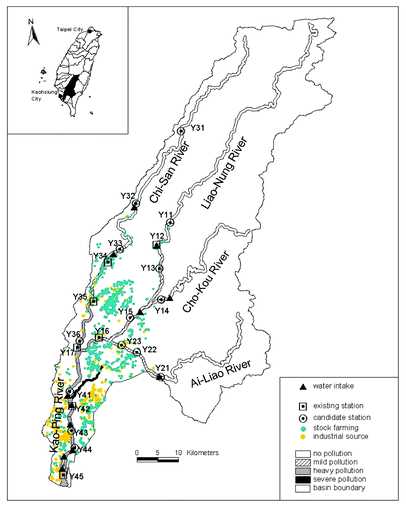 | ||
| Fig. 1 The candidate stations of the water quality monitoring network and the current situation in the Kao-Ping River Basin, Taiwan. | ||
The Kao-Ping River system has a long history of high biochemical oxygen demand (BOD) and ammonia nitrogen (NH3-N) concentrations due to inadequate disposal of manure from stock farming, industrial effluents and domestic wastewater discharges. The continuous discharge of various types of wastewater into flowing water in the middle and downstream areas, where most water intakes are located in this region, requires the application of a systematic policy to improve water quality. A TMDL program was started in 1998, which requires a sound water quality monitoring system to support the essential assessment in the later stage.
Determination of preference weights
The design procedure for the optimization of monitoring systems needs to identify several significant planning objectives and to consider a series of inherent constraints simultaneously. The consideration of multiple objectives may require further decision analysis to determine the preference weights associated with the objectives to aid in the decision-making process. This may require an optimization study to extract such information and evaluate the overall effectiveness of locating strategies. This paper emphasizes that the mathematical programming technique is capable of investigating the preference weights with respect to a set of designated planning objectives. With a pre-emptive goal programming model, the implicit decision weights can be elicited from the questionnaire outputs when a knowledge of how the domain experts take the objectives into account separately and collectively is apparent. This paper represents the first effort to apply such a new scheme to solve environmental problems.Questionnaire investigation
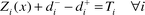
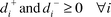
The planning objectives considered in this analysis were designed to address the degree of protection of those areas in the river system with high population density, to enhance the detection probability for low compliance areas, to enhance the potential detection sensitivity by better locating strategies, to reflect the utilization potential of the water body at different locations and to monitor the water quality upstream of all water intakes. Five main river basins in Taiwan were selected as candidates for further assessment of how well the monitoring stations were sited in each river basin with respect to the five designated planning objectives. With a questionnaire designed explicitly to elicit the performance of existing networks, 15 experts in the field of environmental management were invited to form an evaluation committee and were requested to grade the monitoring system situated in each river basin sequentially with regard to the objectives. The possible grade range should be defined in advance in order to obtain a set of consistent outputs. All experts in the evaluation committee have to grade not only the respective performance with respect to individual objectives, but also the integral performance with respect to each system. Final consensus was made by the evaluation committee to pinpoint exactly which monitoring project in the river basin was best in a logical sense, and a priority list was produced for subsequent goal programming analysis.Fig. 2 shows the 21 river basins in Taiwan. Five of them, including the Dan-Shui, Tou-Qian, Da-Jia, Tseng-Wen and Kao-Ping, are regarded as the main river basins, which have been selected as candidates for evaluation in this analysis. To perform an effective investigation through questionnaire, information on the water quality monitoring networks being planned and built in these five main river basins was collected, including population density, locations of water intakes, severity of water pollution and utilization levels of water body along the river reaches. Fig. 3 demonstrates a typical example in the Kao-Ping River Basin, while Table 1 summarizes all the related information based on a comparative approach.
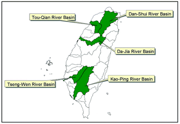 | ||
| Fig. 2 The five river basins in Taiwan selected for questionnaire investigation in preference weights analysis. | ||
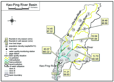 | ||
| Fig. 3 The current situation in the Kao-Ping River Basin. | ||
| Dan-Shui River | Tou-Qian River | Da-Jia River | Tseng-Wen River | Kao-Ping River | |||||||||||
|---|---|---|---|---|---|---|---|---|---|---|---|---|---|---|---|
| Up-stream | Middle stream | Down-stream | Up-stream | Middle stream | Down-stream | Up-stream | Middle stream | Down-stream | Up-stream | Middle stream | Down-stream | Up-stream | Middle stream | Down-stream | |
| a A, no pollution; B, mild pollution; C, heavy pollution; D, severe pollution. b A, sparse (<50 capita km−2); B, moderate (50–500 capita km−2); C, many (500–1000 capita km−2); D, crowded (>1000 capita km−2). | |||||||||||||||
| Pollution situationa | A | B–C | D | A | A | A | A | A | B | A | B | C | A | B | C–D |
| Average slope of river bed | 1/37 | — | 1/6700 | 1/190 | 1/90 | 1/200 | 1/150 | ||||||||
| Population densityb | A | D | D | A | B | D | A | C | D | A | B | C | A | B | D |
| Existing gage station | 9 | 12 | 0 | 4 | 2 | 0 | 12 | 5 | 0 | 0 | 2 | 2 | 3 | 3 | 0 |
| Existing water quality monitoring station | 1 | 38 | 13 | 4 | 2 | 2 | 0 | 5 | 3 | 0 | 4 | 2 | 2 | 7 | 3 |
The grade range used to determine the possible achievement of each objective was 1–5. Table 2 presents the mean scores with respect to each objective for the five river basins selected in this survey. The normalization of the preference weights requires the collection of more information. The final consensus with regard to the integral evaluation of the five main river basins includes: (i) the Dan-Shui River is generally better than the Tou-Qian River; (ii) the Dan-Shui River is generally better than the Da-Jia River; (iii) the Dan-Shui River is generally better than the Tseng-Wen River; (iv) the Da-Jia River is generally better than the Tseng-Wen River; and (v) the Kao-Ping River is generally better than the Tseng-Wen River.
| River basin | Objective 1 | Objective 2 | Objective 3 | Objective 4 | Objective 5a |
|---|---|---|---|---|---|
| a Objective 1, to enhance the detection probability of lower compliance areas. Objective 2, to reflect the utilization potential of the water body at different locations. Objective 3, to promote the potential detection sensitivity by better locating strategies. Objective 4, to increase the degree of protection for those areas with higher population density in the river system. Objective 5, to monitor the water quality at all upstream water intakes. | |||||
| Dan-Shui | 3.75 | 2.75 | 4.25 | 2.50 | 1.75 |
| Tou-Qian | 4.25 | 3.25 | 2.25 | 1.75 | 3.50 |
| Da-Jia | 4.75 | 3.00 | 3.5 | 1.75 | 2.00 |
| Tseng-Wen | 4.25 | 3.50 | 3.00 | 2.75 | 1.50 |
| Kao-Ping | 3.00 | 3.00 | 4.00 | 1.75 | 3.25 |
Based on the outputs from both respective and integral performance evaluation, an optimization analysis can be applied to extracting and normalizing the preference weights. Using a goal-programming model could acquire the preference weights for all objectives simultaneously. This approach may exhibit more consistent outputs rather than present a straightforward mean value based on overall individual grades.
Pre-emptive goal programming analysis
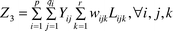
The approach used to elicit the preference weights is based on goal programming analysis (see Appendix 1 for details). The database obtained from the 15 questionnaires was used in a goal programming model to elicit final preference weights for all objectives. The weight associated with each objective was initially set to fall above 0.1 in the constraint set. Such technical setting preserves the minimum sensitivity for each objective considered in this survey. Otherwise, some may be excluded in the trade-off process. The algorithm yielded final normalized weights of {0.21, 0.10, 0.27, 0.19 and 0.23} respectively.Multi-objective programming
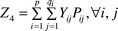
The second stage analysis eventually leads to a multi-objective mixed integer programming model subject to several inherent constraints for screening the candidate sites in a river system with respect to the preference weights determined above. The detailed formulae are described in Appendix 2. The planning objectives are designed to address the degree of protection of those areas with a high population density in the river system, to enhance the detection possibility for low compliance areas, to promote the potential detection sensitivity by better locating strategies, to reflect the utilization potential of the water body at different locations and to monitor the water quality upstream of all water intakes. The constraint set contains the budget limitations, the implication of equity concerns and the detection sensitivity in the water environment. Four factors, including dissolved oxygen (DO), biochemical oxygen demand (BOD), total phosphorus (TP) and ammonia-nitrogen (NH3-N), are considered in this case study for screening the monitoring stations in the optimization scheme. The year can be divided into two seasons in a hydrological sense in this river system. The wet season generally covers the time period from May to October, and the remaining time period is the dry season. As there is a difference in stream flow rate between the wet and dry seasons, only the situation in the dry season needs to be considered in the design procedure of the water quality monitoring network.Twenty-one monitoring station sites have been selected as candidates in the Kao-Ping River system, of which seven are current (Fig. 1). Most of the existing stations are located in the downstream area close to the high population region. The use of a geographical information system (GIS) to help determine the essential parameters for each site is viewed as an indispensable tool in this analysis. With the aid of QUAL2E31 simulation outputs, the half-life distance (see Appendix 2, sub-objective 3 for an explanation) for each pollutant of concern around each candidate site may be obtained.32 Such information is used in the formulation of the third objective function [eqn. (12) in Appendix 2] and the second constraint [eqn. (17) in Appendix 2]. The situation of attainment or non-attainment of water quality in the river system, needed for the first objective function, can be acquired from the previous sampling and analysis program.32 Spatial analysis, such as that in the ArcView® GIS software package,33 may be helpful in determining the population density within a 10 km radius of each monitoring station. GIS is also useful for measuring the geographical distance between each candidate monitoring station and a reference point, such as the estuary location or water intake. The spatial information associated with the three utilization levels of the water body must also be included in the model formulation. The optimal relocation and expansion strategies for the water quality monitoring network can be realized as a multi-objective optimization analysis, solved using a software package such as LINDO®.34
The final planning scenarios depend critically on the chosen upper bound of the total number of stations in the constraint and whether the existing stations are included or not. They are listed at the bottom of Fig. 4. Given the preference weights previously obtained, the conflict and compromise between the five planning objectives can be observed. For example, the second objective tries to emphasize the importance of conserving the higher water quality regions in the upstream area, while the fourth objective focuses on the protection of those non-attainment areas close to the estuary region where the population density is higher than the others. Equity concerns force the final selection of candidate sites to be uniformly distributed throughout all tributaries in both the relocation and expansion scenarios.
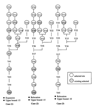 | ||
| Fig. 4 The results of optimal planning programs of the water quality monitoring network. | ||
When considering the relocation strategy, the trade-off mechanism in the multi-objective evaluation framework clearly differentiates the potential of all candidate sites. The resulting locating strategies of scenarios (1) and (2), defined in Fig. 4, show that the deployment of the current water quality monitoring network in the Kao-Ping River Basin does not conform to an optimal design. At least the existing monitoring stations have no special consideration for monitoring those water intakes. Further, there will be little chance to choose adjacent sites in an optimal siting scheme when applying the multi-objective evaluation framework. For example, scenario (2) excludes adjacent sites in the river system at least twice. Such differentiation covers the adjacent sites denoted by Y16/Y17 and Y34/Y35. On the other hand, although a planning scenario involving network expansion results in a smaller impact for the managerial authority, it may lose part of its integrity because the optimal locating strategy will be limited by the existing pattern and cannot exhibit a better overall spatial distribution. Candidate monitoring stations located in the upstream area are frequently included in the optimal locating process as a result of the requirements for higher detection sensitivity, larger utilization potential and an early warning system for preserving water quality around the water intakes. This is shown by solutions (2) and (3).
Conclusions
Planning a sound water quality monitoring network in a river basin in response to the needs of a national water quality monitoring goal is a complex and challenging task. This paper illustrates how preference weights analysis, calibrated simulation modeling and multi-objective optimization analysis can be combined to achieve the system-based planning goals, leading to a search for both optimal relocation and expansion strategies for the water quality monitoring system in the Kao-ping River Basin in south Taiwan. It is believed that this unbiased and trustworthy decision procedure may provide a powerful means to establish many other optimal designs of water quality monitoring networks in river systems.Appendix 1: Formulation of goal programming model
The following formulation is a generic form of the pre-emptive goal programming model: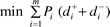 | (1) |
 | (2) |
 | (3) |
 | (4) |
 | (5) |
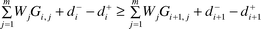
The integral performance evaluation in this analysis may generate a set of comparative goals that would not exhibit obvious priority in the context. Owing to the inherent limitations of the questionnaire investigation, there may be a need to use an optional constraint, as defined in eqn. (8), to ensure that the preference weight elicited in the optimization analysis becomes positive; otherwise, the removal of some objectives that yield zero preference weights is inevitable. In addition, for describing the preference order of integral assessment among similar projects, a sound constraint set is set up as defined in eqn. (7). The modified model formulation is as follows:
 | (6) |
 | (7) |
 | (8) |
 | (9) |
The weights can be determined by optimization analysis and software packages, such as LINDO®.34
Appendix 2: Formulation of multi-objective programming model
Objective function
The components (sub-objectives) of the final objective function [eqn. (15)] are as follows.(1) Maximization of the detection possibility for lower compliance areas. Compliance monitoring, i.e. detecting violations of regulations is a primary requirement. This objective indicates that the monitoring network to be built (or expanded) should exhibit the highest potential capability to detect the severely polluted areas with respect to the set of pollutants of concern. It can be expressed as:
 | (10) |
(2) Maximization of the utilization potential of the water body at different locations. The higher the utilization potential of a water body in the river reach, the greater is the requirement to the monitoring station(s) in it. This may be expressed as:
 | (11) |
(3) Maximization of the potential of detection sensitivity by better locating strategies. The monitoring station locations in the river system must take pollutant transport and degradation capability into account. This is strongly related to the assimilative capacity of the local environment. The design criterion emphasizes that the spatial locations of sites in an optimal monitoring network should be based on the overall detection sensitivity or alarm potential with respect to the set of pollutants of concern. A parameter, the half-life distance, is defined in advance according to the output from the simulation model. The longer the half-life distance for a pollutant in the proximity of a specific candidate site, the lower the chance for a neighboring candidate site to be selected as an alternative. This is obtained by:
 | (12) |
(4) Maximization of the degree of protection of those areas with high population density in the river system. Monitoring stations should be sited as close as possible to the locations in where most population resides in the river basin. This criterion is designed as:
 | (13) |
(5) Maximization of the monitoring potential for water quality at all upstream water intakes. Monitoring stations should be sited as close as possible to the locations at which water intakes are situated. This is given by:
 | (14) |
The final objective function is then given by:
 | (15) |
Constraint set
The formulation of the constraint set is illustrated as follows.(1) Budget constraint. The total number of monitoring stations included in the alternative should be less than an upper bound, defined with respect to budget limitations:
 | (16) |
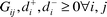
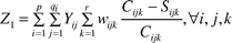
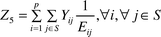
(2) Detection sensitivity constraint. The overlap of the half-life distance between each pair of adjacent monitoring stations should be minimized. A one-dimensional coordinate system is defined starting from the estuary location and continuing to the origin, i.e. the farthest location of the upper stream area. Fig. 5 illustrates the coordinate system. The ‘effectiveness of coverage’ of each monitoring station in a spatial sense is addressed using an aggregate index relating to the half-life distance of all constituents of concern. Several external runs via simulation analysis are required to illustrate how far the half-life distance of each monitoring station is with respect to all pollutants of concern. Preference can be assigned to a specific monitoring station or pollutant by setting wijk in the equation:
 | (17) |
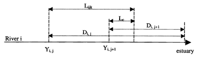 | ||
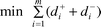
| Fig. 5 Coordinate system diagram used in this study. Yij, the jth candidate site located at the ith tributary; Dij, the distance between the jth monitoring station located at the ith tributary and the reference point of estuary location (km); Lijk, the half-life distance associated with the candidate site (km); Lc, limitation of the overlapped influential distance allowed in this systems analysis (km). | ||
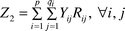
(3) Equity constraint. This ensures that each tributary in the river basin contains at least one monitoring station:
 | (18) |
(4) Non-negativity constraint. All the binary decision variables (Yij) are defined as non-negative.
References
- N. B. Harmancioglu, V. P. Singh and M. N. Alpaslan, Environmental Data Management, Kluwer Academic Publishers, Boston, MA, 1998. Search PubMed.
- S. F. Moore, J. Hydraulics Division, ASCE, 1973, 99, 815–831 Search PubMed.
- C. V. Beckers and S. G. Chamberlain, Design of Cost-effective Water Quality Surveillance Systems, US EPA-600/5-74-404, US Environmental Protection Agency, Washington DC, 1974 Search PubMed.
- D. P. Lettenmaier, Water Res. Bull., 1978, 14, 884–902 Search PubMed.
- R. C. Ward, Water Res. Bull., 1979, 15, 369–380 Search PubMed.
- J. R. Skalski and D. H. Mackenzie, J. Environ. Magn., 1982, 14, 237–251 Search PubMed.
- S. Groot and T. Schilperoot, Water Sci. Technol., 1983, 16, 275–287.
- B. G. Van and J. P. Hughes, J. Water Pollut. Contl. Fed., 1983, 55, 400–404 Search PubMed.
- D. P. Lettenmaier, D. E. Anderson and R. N. Brenner, Water Res. Bull., 1984, 20, 473–481 Search PubMed.
- P. H. Whitfeld, Water Res. Bull., 1988, 24, 775–780 Search PubMed.
- J. C. Ellis, Handbook on the Design and Interpretation of Monitoring Programs, Publication NS 29, Water Research Center, Medmenham, 1989. Search PubMed.
- D. G. Smith and G. B. McBride, Water Res. Bull., 1990, 26, 767–775 Search PubMed.
- J. C. Loftis, G. B. McBride and J. C. Ellis, Water Res. Res., 1991, 27, 255–264 Search PubMed.
- S. R. Esterby, A. H. El-Shaarawi and H. O. Block, Environ. Monit. Assess., 1992, 23, 219–242 CAS.
- R. E. Kwiatkowski, Environ. Monit. Assess., 1991, 17, 253–271 CrossRef.
- P. F. Hudak, H. A. Loaiciga and M. A. Marino, J. Hydrol., 1995, 164, 153–170 CrossRef CAS.
- N. B. Harmancioglu and M. N. Alpaslan, Water Res. Bull., 1992, 28, 179–192 Search PubMed.
- S. E. Cieniawski, J. W. Eheart and S. Ranjithan, Water Res. Res., 1995, 31, 399–409 Search PubMed.
- S. L. Lo, J. T. Kao and S. M. Wang, Water Sci. Technol., 1996, 34, 49–57 CrossRef CAS.
- W. Dixon and B. Chiswell, Water Res., 1996, 30(9), 1935–1948 CrossRef CAS.
- J. G. Timmerman, M. Adriaanse, R. M. A. Breukel, M. C. Oirschot, M. Van and J. J. Ottens, Eur. Water Pollut. Contl., 1997, 7, 21–30 Search PubMed.
- W. Dixon, G. K. Smith and B. Chiswell, Water Res., 1999, 33(4), 971–978 CrossRef CAS.
- M. Z. Siddiqui, J. W. Everett and B. E. Vieux, J. Environ. Eng. (ASCE), 1996, 122, 515–523 Search PubMed.
- K. Charnpratheep, Q. Zhou and B. Garner, Waste Magn. Res., 1997, 15, 197–215 Search PubMed.
- P. Leung, J. Muraoka, S. T. Nakamoto and S. Pooley, Fisheries Res., 1998, 36, 171–183 Search PubMed.
- T. L. Satty, The Analytic Hierarchy Process, McGraw-Hill, New York, 1980.
- T. L. Satty and L. G. Vargas, The Logic of Priorities, Kluwer Nijhoff, Boston, 1982.
- H. C. Zhang and S. Y. Yu, IEEE Int. Symp. Electron. Environ., 1999, 280–285 Search PubMed.
- M. E. Qureshi and S. R. Harrison, J. Environ. Magn., 2001, 62, 101–112 Search PubMed.
- C. C. Wen and C. S. Lee, Water Res. Res., 1998, 34, 427–436 Search PubMed.
- L. C. Brown and T. O. Barnwell, The Enhanced Stream Water Quality Model QUAL2E and QUAL2E-UNCAS: Document and User Manual, EPA/600/3-87/007, US Environmental Protection Agency, Environmental Research Laboratory, Athens, GA, 1987 Search PubMed.
- S. K. Ning, N. B. Chang, L. Yang, H. W. Chen and H. Y. Hsu, J. Environ. Magn., 2001, 61, 61–76 Search PubMed.
- User's Manual for ArcView® Version 3.1, Environmental Systems Research Institute Inc., Redlands, CA, 1998 Search PubMed.
- L. Schrage, User's Manual for Linear, Integer, and Quadratic Programming with LINDO, Release 5.0, The Scientific Press, South San Francisco, CA, 1991 Search PubMed.
| This journal is © The Royal Society of Chemistry 2002 |