
 Open Access Article
 This Open Access Article is licensed under a Creative Commons Attribution-Non Commercial 3.0 Unported Licence
Ongoing legacy contamination from a military radar station in Iceland: a case study
María J.
Gunnarsdottir

Institute of Environmental Engineering, University of Iceland, Iceland. E-mail: mariag@hi.is
First published on 13th May 2024
Abstract
Contamination in and around military radar stations in the Arctic has been an ongoing concern since first identified in the 1980s. This study reports on the environmental impact from a DEW line US military station that was operated on Heiðarfjall mountain in northeast Iceland from 1957 to 1970. This review is conducted as a part of work of the POPs Expert Group of the Arctic Monitoring and Assessment Program (AMAP) for an assessment report on local sources vs. long-range transport of Persistent Organic Pollutants (POPs) in the Arctic. The main resource for this summary is an evaluation of results from several reports on Heiðarfjall Langanes, one from an Icelandic Environmental Authority in 1993 and another from the Canadian Environmental Science Group (ESG) at the Royal Military College of Canada, which was commissioned in 2017 by the owners of the land that was used for the station. The results are compared to findings in scientific papers and reports for contamination at other military radar stations in Canada and Alaska. This review shows considerable contamination on Heiðarfjall over 50 years after the closure of the station and is consistent with findings at other former military stations of the same era and with recent preliminary results from environmental investigation by the Norwegian Geological Institute (NGI). The dump area has around 13 thousand m3 of soil contaminated with petroleum hydrocarbons (PHCs), lead, mercury and tin. The communication area and surrounding are contaminated with polychlorinated biphenyls (PCBs), lead and mercury. In other areas storing oil, soil samples reveal elevated concentrations of PHCs. New monitoring results by NGI with passive water samplers show PCBs 20-fold above the guideline value in a water source below Heiðarfjall, and the prediction and dispersion model indicated an increased concentration of PCBs there for decades to come. From new knowledge on the impact of climate change on the release of contaminants as POPs, it can be concluded that there is a need for further cleanup of the area. The potential for future releases due to climate warming should be included in risk assessments of contaminated military and industrial sites in the Arctic.
 María J. Gunnarsdóttir | María J. Gunnarsdóttir received a BSc degree in Civil and Constructional Engineering from the Technical College of Iceland in 1979, followed by an MSc in Environmental Science in 2005 and PhD in Environmental Science and Natural Resources in 2012 from the University of Iceland. She worked at the National Energy Authority and Icelandic Federation of Energy and Utility Companies from 1980 to 2009. Since 2009 she has been working at the University of Iceland in the Faculty of Civil and Environmental Engineering as a senior research scientist, teacher, and project manager. Her main research topics have been water supply, drinking water quality and water safety planning. She has published over twenty articles on the subject in scientific journals. |
Environmental significanceThis paper is a summary of environmental impacts from a former US military DEW line radar station in Iceland which operated from the mid-1950s to the 1970s. This station was one of four DEW line station stations that operated in Iceland during the Cold War era. During the time of operation and when dismantled, nearly all waste from the station was dumped in unlined pits on the mountain. Very limited cleaning of the site has been performed and the site is contaminated with PCBs, PHCs, PAHs and some inorganic elements. |
Introduction
Brief history of DEW line stations
The Distant Early Warning (DEW) line radar stations were built by the US Air Force in the 1950s along the Arctic circle in North America, Greenland and Iceland, to protect North America from Soviet invasion via the Arctic.1 The DEW line was intended to provide a two-hour warning to the USA and southern Canada against manned Soviet bombers. It consisted of 63 stations and ran from the St Lawrence Island in the Bering Sea, along the northern shores of mainland Alaska to Cape Dyer on the Baffin Island coast in the Canadian Arctic and was extended by stations in Greenland (4) and Iceland (4). It was one of the most expensive military projects initiated in peacetime.2,3 As it could not warn of the later developed intercontinental ballistic missiles, it became of limited use. In 1985, the US and Canada agreed to replace the DEW line with a new satellite-based system. They also agreed to clean up the old sites, as most of the sites were contaminated with PCB solvents, heavy metals such as mercury (Hg) and lead (Pb), and petroleum hydrocarbon products together with barrels and debris dumpsites.4,5Environmental assessments were conducted at all 42 DEW line stations in Canada from 1989–1993, and a DEW Line Cleanup Protocol was developed as a result of this work.4,6 The protocol provided standardized risk management and remediation approaches based on contaminant type and concentration. The protocol requires soil contaminated with PCBs at more than 50 mg kg−1 soil to be shipped to a licenced disposal facility, 5–50 mg kg−1 isolated with barriers (e.g., an engineered, lined waste disposal facility) from the Arctic ecosystem, and 1–5 mg kg−1 to be buried in a non-hazardous landfill.7 Remediation techniques are described in Kalinovich et al.8 and Granberg et al.9
The DEW line station at Heiðarfjall Iceland
Iceland has been a member of the North Atlantic Treaty Organization (NATO) since its foundation in 1949 and, as stated on the website (Government of Iceland|National Security (https://www.government.is/topics/foreign-affairs/national-security)) of the government of Iceland, has had a Bilateral Defence Agreement with the United States since 1951 as Iceland is a country without military. During the Cold War era, the US military began operating four DEW line radar stations to monitor air traffic around Iceland. One of the four stations in Iceland, designated as H-2 (Langanes), was built on Mt. Heiðarfjall in the Northeast, see Fig. 1. The other three were Mt. Straumnesfjall (Straumnes) H-4 in the Northwest, Stokksnes (Hofn) H-3 in the Southeast and Keflavik (Rockwille) H-1 in the Southwest.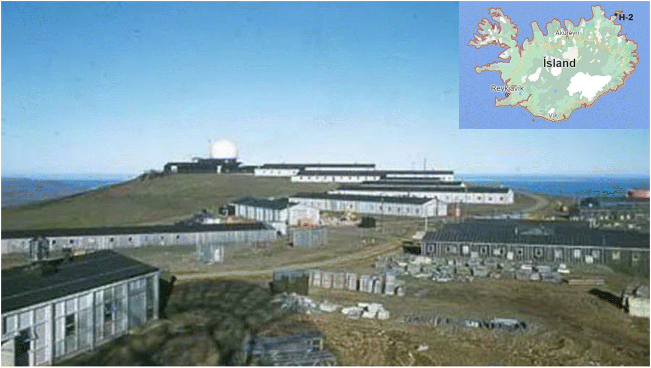 | ||
| Fig. 1 The DEW line radar station at Heiðarfjall in 1958 (https://www.radomes.org/museum/acwgrnland.php). | ||
The H-2 radar station at Heiðarfjall (66°16′42′′N 14°59′32′′W) was operated from 1957 until 1970, by the US Air Force until 1961 and after that by the US Navy watching submarine traffic until 1970 when the station was closed down and later demolished. The radar station was built on the top of Heiðarfjall mountain, approximately 260 metres above sea level. The mountain is part of the land of Eiði farm, which was leased by the Icelandic government in 1953 and handed over to the US military in 1955.10 It is estimated that between 100 and 130 people stayed permanently at the station during operation. During that time, almost all waste from the station was dumped in unlined pits on the mountain and then later, when the radar station was dismantled, on-site burying and levelling was done by the Icelandic Surplus Agency in the seventies and later in the eighties by the local rescue group Hafliði.
Heiðarfjall mountain and its surroundings are now mainly a grazing area for sheep and a habitat for wildlife. The farm Eiði is now used for intermittent residence and the drinking water source for the farm is on the southern side of the mountain, directly below the radar station, approximately one kilometre away (Fig. 2 and 3). The estuary lake Eiðisvatn has an area of 1.9 km2 and a depth of approximately 3 meters and provides habitat for char and waterfowl. Three farms in the vicinity of Heiðarfjall are with permanent residency, Hlið, Ytra Lon and Saudanes, situated 5 to 12 km away. A fishing village, Torshavn with ca. 500 inhabitants, is 18 km from the station. The airport used by the military was at Saudanes (not in use now). The biosphere around the mountain includes birds, foxes and sheep, approximately 1500 during the summer months. Shooting of partridge is practiced and fishing in the many lakes for trout is popular, and Langanes is also a popular tourist destination. The farm Eidi was sold in 1974, and the new owners soon began preparations for fish farming in Lake Eidisvatn which was showing good results (MBL 20th August 1986). However, because of suspected contamination from the nearby DEW line station, they were advised to stop the project which they did in the late eighties (personal information: Ránar Jónsson, Langanesbyggd).
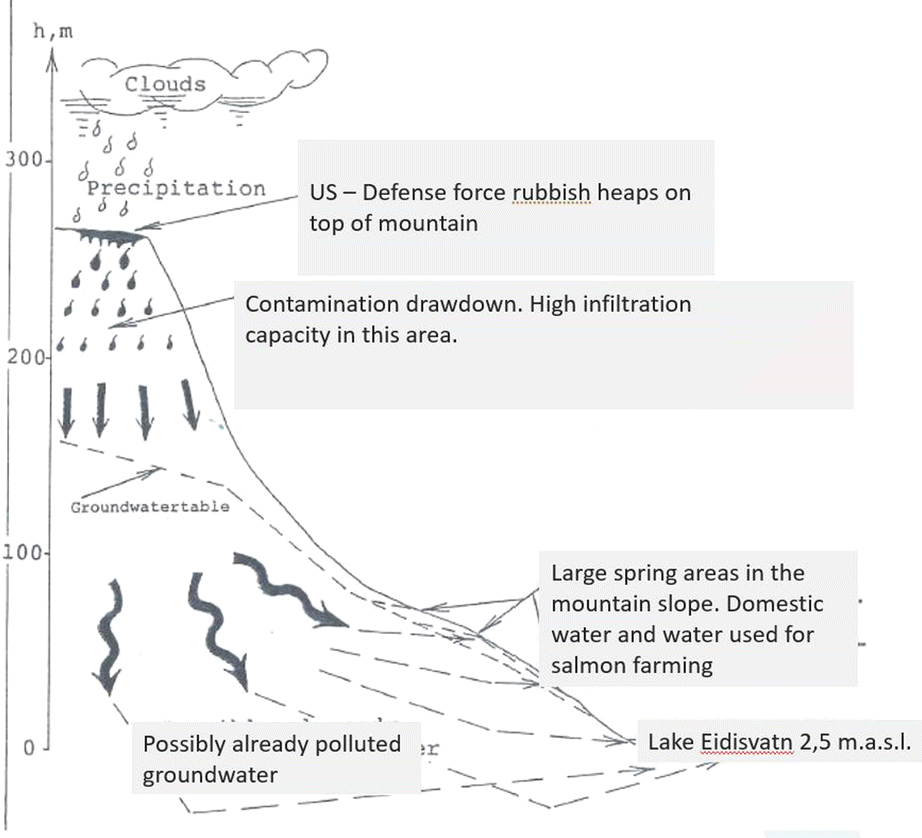 | ||
| Fig. 2 Transport model of pollution spread at Heiðarfjall.42 | ||
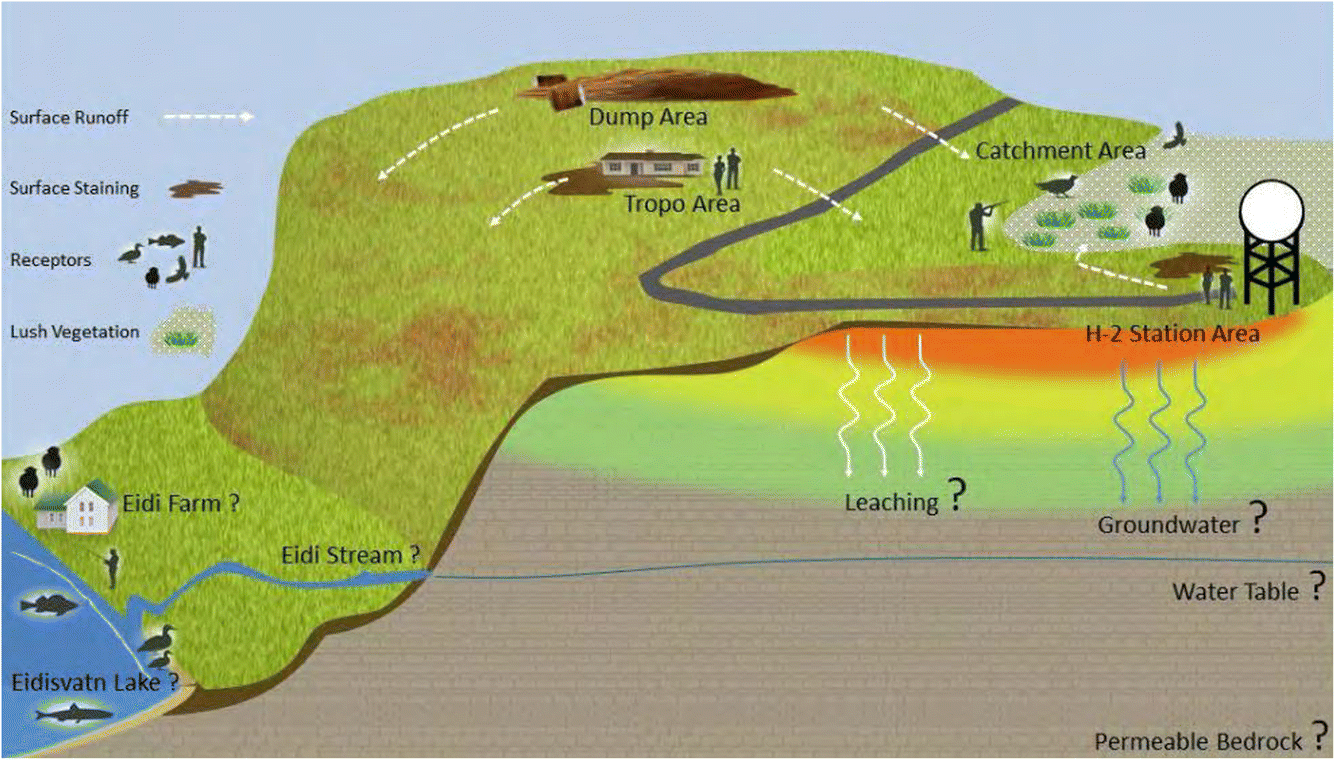 | ||
| Fig. 3 Schematic picture of Heiðarfjall and the sites investigated by the ESG in 2017.10 Water source for Eidi farm is at the Eidi stream. | ||
Critical environmental issues are the potential for contaminants leaking from the former DEW line and other military sites to migrate into the biosphere and to the nearby human and ecological receptors, as has been revealed in numerous studies.11–16 At Heiðarfjall, there is the risk that contamination will impact the biosphere all around the mountain, the pond which is the only source of water on the mountain for livestock and birds, the water source for the farm Eidi, the biosphere in the lake Eiðisvatn and the sea directly below the mountain. The sea around Langanes is an important feeding ground for fish. The current owners have been demanding clean-up and environmental impact investigation of the area since the late seventies.
POPs and climate change in the Arctic
Localized POP contamination has been documented in the Arctic at the DEW line stations in North America and elsewhere and has been registered as a significant source of contamination in the Arctic and in the Antarctic.1,17 The local influence on the surrounding environment from these sites has been termed the “halo effect”, and PCB contamination has been detected in soil and vegetation in an up to 10 km radius (300 km2 per site) from DEW line areas.1,17–20For example, at the station at Resolution Island (Nunavut, Canada), located on south-eastern Baffin Island, the clean-up began in 1999 and was completed in 2006, which involved remediation of 5 tonnes of pure PCBs in approximately 20 thousand m3 of soil.7 When the station was abandoned in 1974, over 8 tonnes of pure PCBs (Aroclor 1260) were left at the site, most of which originated in and around the communications building.4 PAHs resulting from petroleum spills at military and industrial sites have been shown in the Arctic for example at a military site outside the city of Utqiaġvik (formerly Barrow), northern Alaska.5 Areas near the airstrips and powerhouse were the most contaminated areas.
In Iceland, the Dew Line station H-1 Rockville was placed at the NAS-KEF (Naval Air Station Keflavik) military base (closed in 2006) and was operated by military personnel stationed there. In 1986, the water source for the towns of Keflavik and Njardvik, which are close to the airport and base, was found to be contaminated. The contamination was e.g. with Volatile Organic Compounds (VOCs, tetra- and trichloroethane), widely used as cleaning and degreasing solvents, and benzene. All values above premitted values for drinking water, up to eight-fold. From time to time, there were oil accidents at the base, the biggest ones in 1987 and 1989. Oil cleaning operations were not successful, and groundwater is heavily contaminated. A large-scale inspection was carried out at the water sources in the area, which eventually resulted in most of them being closed, and a new water source, around 12 km away, was harnessed and paid for by the US military.21–23 This new water source is now under threat from volcanic activity on the Reykjanes peninsula.
PCBs originating at the DEW line sites have been documented in nearby habitats, wildlife, and people in Arctic Canada and Alaska.12,14,15 Near several former DEW line stations in Alaska, Scrudato et al.13 reported elevated concentrations of PCBs and mercury (Hg) in soil samples and plants. Elevated Hg and PCBs and other POPs have been found in fish such as Dolly Varden (Salvelinus malma) and ninespine stickleback (Pungitius pungitius) near the former DEW line station on St. Lawrence Islands in Alaska.14,24,25 Carpenter et al.12 determined serum levels of PCBs in Siberian Yupik adults from St. Lawrence Island, Alaska. They concluded that atmospheric transport of PCBs contributes to levels in the Yupik people, but that the abandoned military site may also contribute to the human body burden in those individuals who have either spent substantial time or consumed food from there.
The Arctic has been recognised as a hemispheric sink for some POPs as defined in the Stockholm Convention.26 Those bioaccumulate in a lipid-rich food web and have an adverse effect on human health and the environment.27,28 The main emission of POPs to the Arctic is with long range transport (LRT) from the industrial and agricultural areas of the lower latitudes either with atmospheric transport or with ocean current. The POPs can also be released locally e.g., sewage, waste sites, military sites, mining. Relative contributions of LRT vs. local emissions may be changing due to climate change both due to the release of POPs with melting ice and permafrost, and due to increased human activity in the Arctic.13,29
The Arctic has been warming faster than the rest of the globe due to climate change.30,31 Recent research has shown four-fold faster warming in the Arctic than the globe during the last 43 years with thawing of permafrost and flooding changing hydrological conditions and stability of infrastructure that can release contaminants.32–35 Permafrost was assumed to provide a good hydrological barrier for movement of contaminants from solid and liquid wastes. Climate warming will change that, and melting permafrost and loss of sea ice will mobilize chemicals and plastic as a secondary source of pollution.36 Langer et al.34 identified over 4500 industrial sites where potentially hazardous substances are actively handled or stored in the permafrost-dominated regions of the Arctic. These sites include industrial and military sites, landfills, drilling sites for oil and gas and exploration, mines, storage tanks, pipelines, and other waste dumps. Air temperature has an effect on POP levels in the environment and has been identified as an important predictor of PCBs as higher temperatures will lead to higher rates of emission of PCBs into the atmosphere through volatilization.37–41 Langer et al.34 concluded that climate change impacts must be integrated into a strategy for clean-up of industrial and contaminated sites.
Results and discussion
Preliminary estimate of travel time of pollutants from Heiðarfjall
In 1989, the landowners at Eidi asked a consulting engineering company, who specializes in groundwater transport modelling, to estimate the spread of pollutants from the dumpsite at Heiðarfjall with infiltration into groundwater. The questions asked were how long it would take the contaminants to reach the springs and how long they would last.The engineering consultant's conclusion was that groundwater pollution would mostly spread southwards towards the farm, the estuary lake Eiðisvatn and the sea as shown in Fig. 2. Calculations of the pollution infiltration flow from the top of the mountain indicate that it would take at least 30 years to reach the springs on the south side of the mountain flowing to Eiði and it would take at least another 70 years until it had disappeared, but some dilution could be expected.42
Geological survey and water sampling
In 1993, the local health surveillance authority in the area requested the Ministry of the Environment to investigate if groundwater was contaminated at Heiðarfjall and the surrounding area. As a result, the Ministry entrusted the Environmental Agency, then named the Health Protection Agency (MHR) with the following three tasks, to map the geology of the mountain and the surrounding area, to take water samples from springs around the mountain to analyse for metals and halogenated organic compounds (AOX as Cl), and to test if any persistent halogen compounds were found in water in oil barrels and soils in the dump area.43The geological mapping showed that the site is in a Pleistocene area with two main types of rocks: lava layers and on top of that fractured rock, with its limit approximately 160 meters above sea level. Between these two layers is a thin sedimentary layer of sand and clay. The summit of Heiðarfjall is formed by a porous fractured rock with high permeability and an estimated hydraulic conductivity of K = 10−3 m s−1. The groundwater level can be expected to be at a similar level to the fractured rocks (160 m). Because contaminants travel more slowly through air-filled pores than through water-filled pores, the authors concluded that it could take a long time to reach the groundwater. This agrees with results from the consulting engineers from 1989.42
Nine sites were chosen by the MHR for water sampling: two of these were surface water sites in a river and lake Eiðisvatn near the farm, and seven were spring sources around the mountain (50–130 m.a.s.l.), one being the spring that is a drinking water source for the farm (50 m.a.s.l.). The monitoring results were compared to international drinking water standards such as those of the EU, WHO, US, DE and CA, and were found to comply with all. Some soil samples were taken from the dump area, along with water samples from two oil barrels that were still at the site. The samples were tested for halogenated organic compounds (AOX as Cl), which were detected to be as high as 30 mg kg−1 in soil and 0.044 and 0.863 mg l−1 in the water in the two barrels chosen for sampling.
In retrospect, the monitoring results show that many heavy metals were measured above the natural background levels (NBL) for groundwater developed for a Pleistocene geological area in Iceland44 and where Heiðarfjall is situated.45 In many cases, the detection limit used when analysing the samples was far above the NBL for Pleistocene. For example, the NBL level for Pleistocene areas in Iceland for arsenic (As), lead (Pb), mercury (Hg), and nickel (Ni) is 0.17, 0.086, <0.002 and 0.24 μg l−1, respectively,44 whereas detection limits in the 1993 investigation were <1 μg l−1 for arsenic, <0.7 μg l−1 for Pb, <0.4 μg l−1 for Hg and <20 μg l−1 for Ni so these results could not reveal any anthropogenic impact in the area.
Standards for safe water for the environment have changed since 1993, with more stringent rules on chemical contamination. For example, the European directive on environmental quality in water policy46 sets the maximum allowable concentration (MAC) for total Hg in surface water at 0.07 μg l−1. The Canadian environmental quality guidelines set the limit for total Hg to protect aquatic biota in freshwater at 0.026 μg l−1 and in marine water 0.016 μg l−1.47 Hence the detection limit for Hg <0.4 μg l−1 in the study in 1993 is not sufficient to reveal compliance with these ecological standards. Otherwise, most results for the inorganic elements in the 1993 study did not exceed MAC. The authors of the report suggested that water sampling be repeated after three years for comparison impact purposes and to detect whether any indicators of contamination impacts had reached the groundwater.
The 2017 Canadian investigation of environmental impact
The landowners asked the Environmental Sciences Group (ESG) of the Royal Military College of Canada in 2017 to investigate the H-2 site at Heiðarfjall for environmental impacts.10 The ESG chose nine areas for investigation based on the historical documentation of activities, such as fuel handling, waste disposal and other activities that could cause an environmental impact and in addition took two samples at the Eidi stream area, one soil and one sediment sample.The sites chosen for sampling by the ESG, see Fig. 3, were: (1) the Dump area (ca. 18.000 m2) where debris, both during operating and later during clean-up, had been buried; (2) the Tropo area, with a communication building (still standing), and where two tropospheric communication dishes once stood; (3) the Sewage Outfall area; (4) the POL (petroleum oil and lubricant) Tank area, where a large fuel storage tank used to be situated. Sites 3 and 4 were on the southern edge of the summit area, directly above the Eiði farm; (5) the Garage area; (6) the Barracks area; (7) the Powerhouse area, and (8) Radome area (sites 5, 6, 7, and 8 are all situated at the Station area); (9) the lower-lying Catchment area, where a concrete drainage pipe was observed leading to a small pond; and (10) the Eiði stream area. Fig. 4 shows a recent picture of the Station area.
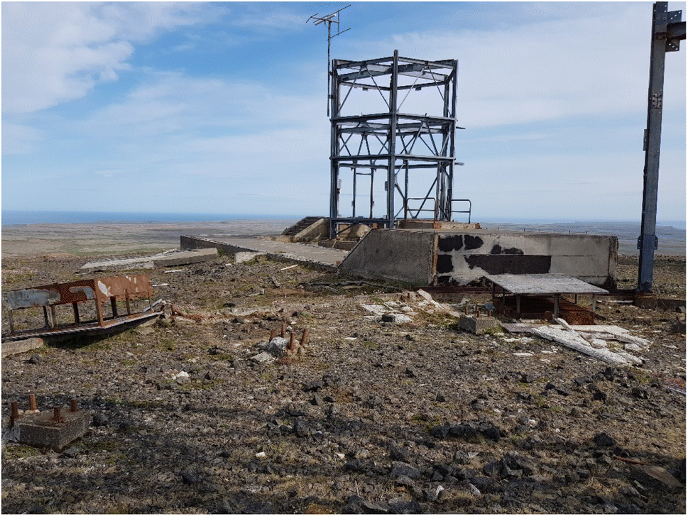 | ||
| Fig. 4 The H-2 Station Radome area at Heiðarfjall, 26. 7. 2021 (M. J. Gunnarsdottir). | ||
The ESG presented a report that included analyses of 30 soil samples, 2 sediment samples (one from the sediment of the pond at the Catchment area and one from the Eiði stream area), and 3 structural material samples in the Tropo building. No water samples were collected because of restrictions on water transport to Canada. All samples were collected over the period August 21–24, 2017.
The samples were shipped to Canada and analysed for PCBs, PHCs, Polycyclic Aromatic Hydrocarbons (PAHs), a suite of VOCs, and 30 inorganic elements. All were analysed by an accredited laboratory ASU of Queen's University Canada according to the standard ISO/IEC 17025.
Table 1 shows the number of analyses for each category of contaminants at each site. Thirty inorganic elements were tested at all ten sites whereas PCBs at nine sites, PHCs and VOCs at six sites and PAHs at five of the ten sites.
| Sample sites | Analysis conducted | ||||
|---|---|---|---|---|---|
| 30 inorganic elements | PCBs | PHCs | PAHs | VOCs | |
| a St. A. = station area; n.a = not analysed. | |||||
| 1. Dump area | 12 | 9 | 1 | 1 | 1 |
| 2. Tropo building area | 5 | 5 | 2 | 2 | 2 |
| 3. Sewage outfall area | 1 | 1 | 1 | 1 | 1 |
| 4. POL tank area | 2 | n.a | 1 | n.a | 1 |
| 5. St. A. Powerhouse | 4 | 4 | 4 | 4 | 4 |
| 6. St. A. Radome | 3 | 3 | n.a | n.a | n.a |
| 7. St. A. Garage | 1 | 1 | n.a | n.a | n.a |
| 8. St. A. Barracks | 1 | 1 | n.a | n.a | n.a |
| 9. Catchment area | 1 | 1 | 1 | 1 | 1 |
| 10. Eidi stream area | 2 | 2 | n.a | n.a | n.a |
| Total analyses | 32 | 27 | 10 | 9 | 10 |
The ESG chose the criteria for compliance from two Canadian and two US guidelines on environmental and human health parameters.47–49 For PHCs, the EGS used the Canada-Wide Standards (CWS) for Petroleum Hydrocarbons (PHCs) in soil, Tier 1 Levels for agricultural land use.50 Concentrations above the lowest numeric level of each substance were used to identify areas of concern.
Table 2 shows the highest value of each pollutant detected in samples at each of the ten sites tested, the lowest guideline value chosen and the 30 inorganic elements that were tested. Six trace elements, arsenic (As), lead (Pb), mercury (Hg), nickel (Ni), silver (Ag), and tin (Sn), were chosen as primary indicators of potential contamination areas because of results from other military sites.
| a St. A. = station area; n.a = not analysed; n.c = not calculated as all PAHs below detection limits. |
|---|
|
Five sites are the most contaminated, Dump, Tropo, Sewage outfall area, Radome, Garage and Catchment areas, all with at least 50-fold exceedance of lowest guideline values: the Dump area with PHC and Pb, Tropo building with PCB, Sewage outfall area with Hg, Radome and Garage areas with Pb and the Catchment area with PHC, Hg and Sn.
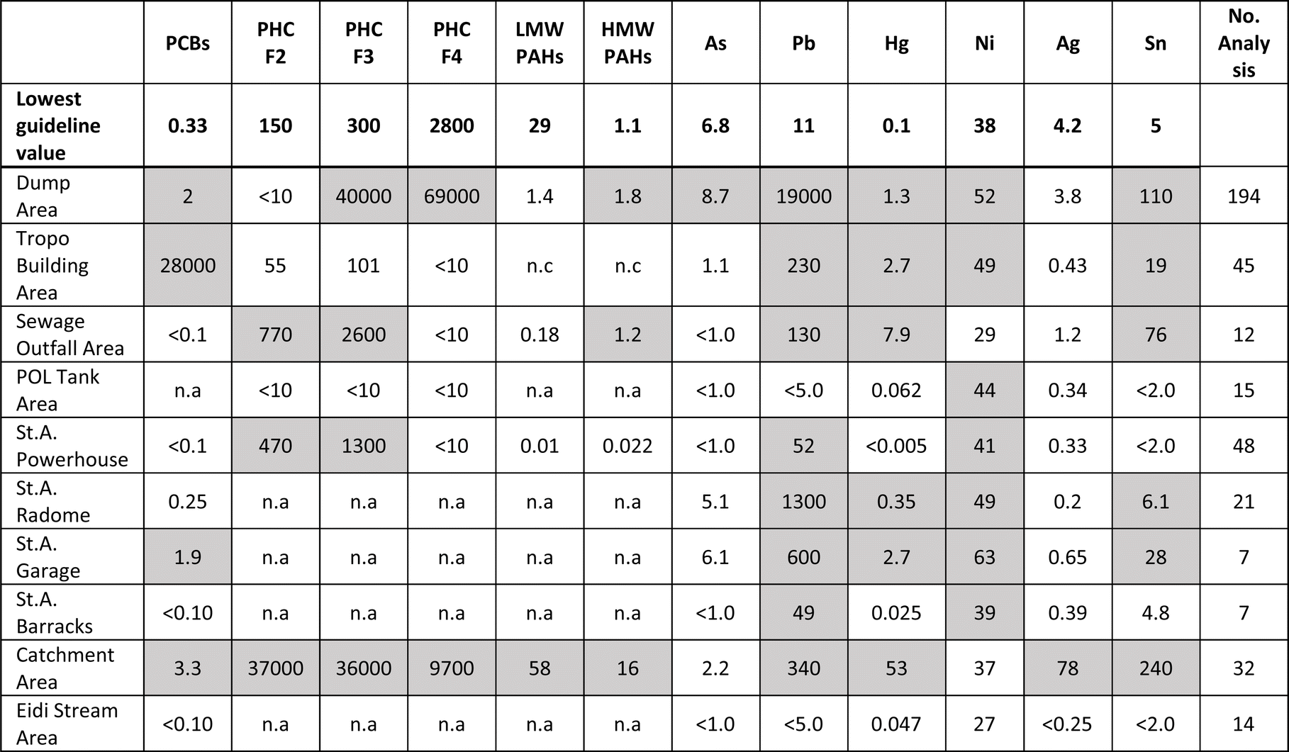
POPs are non-compliant to the lowest guideline value, as shown in Fig. 5, from 11% for low molecular weight PAHs to 70% for PHCs. However, this is not representative as sampling is not evenly distributed and several sites are not tested for some POPs as shown in Table 1.
 | ||
| Fig. 5 Non-compliance of POPs with the LGW (lowest guideline value) in samples.10 | ||
PCBs
PCBs were formerly used in various industrial and consumer products but are now banned. At military stations, they were used in electrical transformers, capacitors, voltage regulators, switches, motor oils and paints. Twenty-seven samples were tested at nine areas for PCBs; of these four areas were above the lowest guideline value (0.33 mg kg−1). These were at the Dump, Trope, Garage, and Catchment areas. The concentration was very high in one sample near the communication Tropo building (28![[thin space (1/6-em)]](https://www.rsc.org/images/entities/char_2009.gif) 000 mg kg−1) just south of the building still standing, whereas it was lower at the other three sites, from six to ten times over the lowest guideline level. It was also quite high in structural material samples (not shown in Table 2) in paint inside the Tropo building (707 mg kg−1). This indicates that PCB contamination is present at least at these sites compared to the criteria given. The DEW line remedial criteria for PCB contaminated soil are 1 mg kg−1.1,4 According to this criterion and ESG results, the four areas at Heiðarfjall would need remedial action, the Dump, Tropo, Garage and Catchment areas. A similar case was at the communication area at Resolution Island in Canada where soil should be deported according to the Canadian clean-up protocol, as mentioned earlier.7
000 mg kg−1) just south of the building still standing, whereas it was lower at the other three sites, from six to ten times over the lowest guideline level. It was also quite high in structural material samples (not shown in Table 2) in paint inside the Tropo building (707 mg kg−1). This indicates that PCB contamination is present at least at these sites compared to the criteria given. The DEW line remedial criteria for PCB contaminated soil are 1 mg kg−1.1,4 According to this criterion and ESG results, the four areas at Heiðarfjall would need remedial action, the Dump, Tropo, Garage and Catchment areas. A similar case was at the communication area at Resolution Island in Canada where soil should be deported according to the Canadian clean-up protocol, as mentioned earlier.7
PHCs
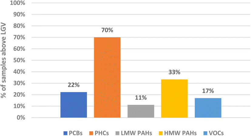
PHCs, used as fuels and lubricants, consist of a large number of hydrocarbon compounds, some of which can cause severe health issues. The ESG observed considerable remains of oil barrels, some of which were stained black, and some black tar like chunks around the Dump area and around the Powerhouse area. Oil barrels were also observed by the MHR in 1993, as mentioned previously.43 PHCs are arranged into four categories (F1, F2, F3, F4) depending on the number of carbons, and their volatility decreases and persistence increases in the environment with a rising number of carbons. PHCs in F1 were not detected over the lowest guideline values whereas this was the case with the other three, to varying degrees. PHCs were tested at six areas and detected over the lowest standard at four areas: the Dump, Sewage outfall, Powerhouse and Catchment areas (Table 2 and Fig. 6). The highest concentration of PHCs ranged from 40000 mg kg−1 to 69000 mg kg−1 at the Dump area and was 9700 to 37000 mg kg−1 at the Catchment area. A similar case was at the DEW line site at Utqiagvik in Alaska where areas around the powerhouse site showed significant petroleum-derived contamination as mentioned earlier.5
 | ||
| Fig. 6 PHCs (mg kg−1) detected above the lowest guideline value for F2, F3 and F4 (150, 300, and 2800, respectively) at four areas. The highest value in each area of the four is shown in the figure. | ||
PAHs
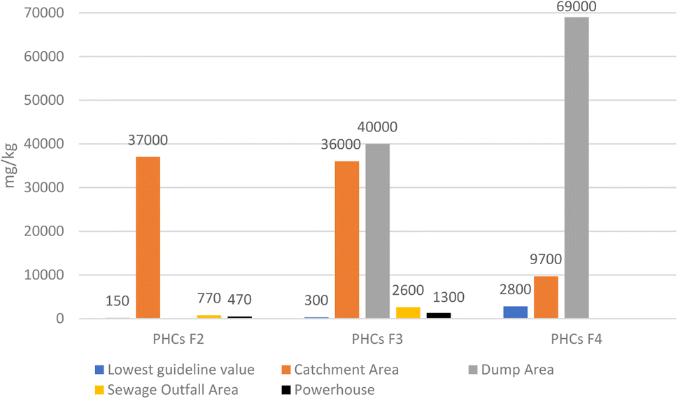
PAHs are released during incomplete combustion of petroleum products or from petroleum spill. They are persistent in the environment and several have multiple adverse health effects.27 PAHs were summarized in two categories, low molecular weight PAHs (LMW PAHs) and high molecular weight PAHs (HMW PAHs), with the latter being more toxic and carcinogenic.51 Fifteen PAHs were tested (5 LMW and 10 HMW) in nine samples from five areas (Dump, Tropo, Sewage outfall, Powerhouse and Catchment), see Table 1, and found to exceed the lowest guideline value at three areas: Catchment, Dump and Tropo areas. The highest values in both categories (LMW and HMW) were found at the Catchment area (Table 2). See Fig. 7 for results for HMW PAHs. | ||
| Fig. 7 HMW PAHs (mg kg−1) tested in five areas with the content exceeding the lowest guideline value (1.1 mg kg−1) in three areas. The highest values detected in the three areas are shown. | ||
VOCs
VOCs are a large group of compounds that have a high vapour pressure and low water solubility, and some are common groundwater contaminants.52 Forty-three VOCs were tested in ten samples in six areas and found on one site, in the sediment by the pond at the Catchment area, where seven of the 43 were detected over the lowest guideline value. Those detected were trichloroethene (2-fold), tetrachloroethane (32-fold), cis-1,2-dichloroethene (4-fold), toluene (3-fold), total xylene (8-fold), isopropylbenzene (2-fold), and 1,2,3-trichlorobenzene (6-fold). The first three are part of a group of synthetic chlorinated solvents that are widely used as cleaning and degreasing solvents.The six priority trace elements: arsenic, lead, mercury, nickel, silver and tin
Thirty-two samples were tested for 30 inorganic elements: four of the six primary trace elements were elevated at the sites: Pb, Hg, Ni, and Sn, with 47% to 78% of the samples exceeding the lowest guideline values, whereas silver and arsenic have less exceedance (3%). The five most impacted areas are the Catchment, Garage, Dump, Radome and Sewage outfall areas. The highest value for lead is at the Dump area (1700-fold), and lead is also high at the Radome and Garage areas (118-fold and 55-fold respectively), and Hg and Sn at the Catchment area (530-fold and 48-fold respectively). Many other inorganic elements were also above the lowest guideline values; for example aluminium, antimony, cobalt, copper, iron, manganese, vanadium, and zinc were frequently above the guideline values. None of the six primary inorganic elements were above the guideline values at the Eiði farm area. However, ten other inorganic elements (not shown here) exceeded the lowest guidelines at the Eiði farm area, especially vanadium and antimony which were 50 and 20-fold higher than the lowest guideline values. Others were aluminium, chromium, cobalt, copper, iron, manganese, sulphur, and zinc, ranging from 2 to 7-fold higher (Fig. 8).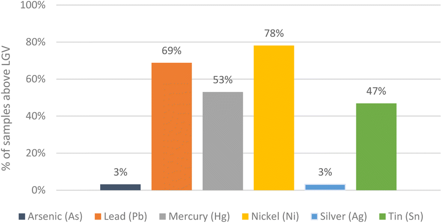 | ||
| Fig. 8 Non-compliance with the lowest guideline value in samples of 6 primary trace elements, measured in 32 samples from the 10 areas chosen by the ESG for investigation at the H-2 area.10 | ||
Studies by the Environmental Agency of Iceland in 2019 and 2023
In 2019, the Environmental Agency of Iceland took four surface water samples from the lake Eiðisvatn, at different times of the year (June, July, September and October), to analyse for priority substances according to the EU environmental quality standard.46 The analysis was done by ALS Scandinavia AB in Sweden accredited according to ISO EN 17025. The substances included PCBs, PAHs, VOCs, Hg, Pb and Sn. All samples complied with the EU standard in these elements and nearly all were below the detection limit. Two organochlorines, alpha-HCH and beta-HCH, both of which are components of technical HCH and are impurities in the insecticide lindane, were detected over the detection limit, however, always below guideline levels for fresh-surface water in US EPA guidelines.49The Environmental Agency (EA) of Iceland assigned the Norwegian Geotechnical Institute (NGI) in 2022 to carry out geophysical and environmental site investigation at H-2 Heiðarfjall. This was to be the first phase in investigating the contamination at Heiðarfjall and was carried out in August 2023. The second phase was to do an environment risk assessment of contaminated soil on Heiðarfjall. This risk assessment calculated the human exposure to contaminants and the transport of contaminants to the groundwater and the surface water. In August 2023, Norwegian Geotechnical Institute, in cooperation with the Icelandic Enviornmental Agency, collected soil and water samples all around Heiðarfjall. Soil samples (56) from the H-2 area, and background soil samples (3) from outside the military area were collected along with 9 water grab samples from: drainage trends and the water source for Eidi farm (4), lakes (3), a pond (at the Catchment) and a groundwater well (used as a water source for the military). Additionally two water samples were collected with passive samplers (DGT and POM) deployed to detect toxic metals and PCBs with much lower detection limits than grab samples. The two samples were taken downstream of Heiðarfjall at a stream near Eidi and in Lake Eidi to monitor PCBs (seven congeners) and metal concentration in water.
The Environmental quality guidelines (EQG) used for soil were the Icelandic regulation on contaminated soil,53 using the “maximum value for land use in business area”. These guidelines values are most often considerably higher than used in the Canadian report, except for PCBs.10 For the water samples, the Norwegian EQG for freshwater was used as criteria54 as not all elements monitored are defined in the Icelandic EQG for water.55
The NGI report56 shows that the Dump area and the Tropo building area are the areas of highest concern where the latter had an elevated concentration of 7-PCB in soil up to 85 mg kg−1. This is significantly higher than the upper limit for class II at 0.5 mg kg−1 in the Icelandic EQG and this result is coherent with the results in the ESG report.10 The Dump area is with a large volume of soil and was estimated by the NGI to be around 13 thousand m3 with debris and waste. Multiple soil samples exceeded the Icelandic EQG for Pb, Cu, Zn, PHCs, PCB and/or dioxins/furans. These results are coherent with the Canadian results.10 In surface water samples, Hg was detected above the Icelandic guideline values in all water samples. Analytical results from passive water sampling at the stream near Eidi farm and from Lake Eidi are above the Norwegian EQG for good status (class II) for 7-PCB, 2.4 × 10⁻⁶ μg l−1versus 4.7 × 10⁻⁵ and 3.9 × 10⁻⁵, respectively, around 20-fold and 16-fold above the guideline value.
The prediction- and dispersion model for five contaminants (Pb, Hg, sum of 7 PCB congeners, benzo(a)pyrene and polychlorinated dibenzo(p)dioxins PCDDs) indicates that groundwater and surface water directly below the mountain at Eidi already have and will in future have a constant increase in PCBs, high above the Norwegian EQG for good status for decades to come while the other four contaminants will be well below. This is coherent with the results of the consulting engineering company Vatnaskil in 1989 (ref. 42) that also predicted the contamination would flow towards Eidi for decades.
Conclusions
The ESG report revealed environmental impact from the H-2 radar station on top of Heiðarfjall mountain and confirmed that the contamination was consistent with findings on other former military installations of the same era. The ESG10 and NGI56 studies both found high PCB levels at the Tropo Communication building, nearby and inside on painted material. The NGI also predicts that PCB contamination will be contaminating water sources for decades to come. High levels of PHCs, derived from unburned petroleum products, were detected by the ESG at Dump, Sewage outfall, Powerhouse and Catchment areas. Nearly all contaminants were found to exceed lowest guideline levels at the Catchment area, and typically at levels many times higher than the guidelines. Specifically, the highest detected values of Hg, Ag, PHCs-F2 and PAHs are present in the one sediment sample taken at the Catchment area. The lower-lying Catchment area at the pond is one of the few areas on Heiðarfjall with surface water. This is of concern because of the potential exposure to farm animals and wildlife. The ESG concluded that the elevated contaminants pose a potential human and ecological health risk at Heiðarfjall and recommended that the site should be further investigated to determine any potential impacts on groundwater and the marine environment.Considering new knowledge on the impact of contaminants on health and ecosystems that have led to stricter environmental standards, it can be concluded from this summary that further investigation and quantification of risk and planning of clean-up of Heiðarfjall station is needed. The other three DEW line stations in Iceland should also be investigated for environmental impact. Contamination from former military sites in Alaska and Arctic Canada has been or is being cleaned up as considerable amounts of waste material, oil drums, PCBs in transformers and paints were left at these sites. Procedures for clean-up of military sites implemented by the Canadian authorities and the experience gained there, in Alaska or elsewhere can be used for comparison when planning the continuation and remedial action. The Arctic is in the frontline of climate change as it is warming much faster than the rest of the globe. This may increase the mobilization of POPs as PCBs through volatilization and mobilization from permafrost degradation as well as from extreme weather events and could lead to a higher release of contaminants.37 This potential for future releases with climate warming should be included in risk assessments of contaminated military and industrial sites in the Arctic.
Conflicts of interest
The author declares no conflict of interest.Acknowledgements
This review paper is part of work of the POPs Expert Group of the Arctic Monitoring and Assessment Program (AMAP) and the author would like to thank the colleagues from that group, especially Derek Muir and Frank con Hippel, for good advice and reviews of this work. The author would also like to thank the many people who contributed with information to this work and the journal reviewers for valuable comments.References
- J. P. Stow, J. Sova and K. J. Reimer, The relative influence of distant and local (DEW-line) PCB sources in the Canadian Arctic, Sci. Total Environ., 2005, 342(1–3), 107–118, DOI:10.1016/j.scitotenv.2004.12.028.
- K. L. Capozza, Ditched drums and all, Bull. At. Sci., 2002, 58(1), 14–16, DOI:10.1080/00963402.2002.11460526.
- M. Hird, The dew line and Canada's Arctic waste: legacy and futurity, N. Rev., 2016, 6(42), 23–45, DOI:10.22584/nr42.2016.003.
- J. S. Poland, S. Mitchell and A. Rutter, Remediation of former military bases in the Canadian Arctic, Cold Reg. Sci. Technol., 2001, 32(2–3), 93–105, DOI:10.1016/j.envpol.2017.11.0545.
- A. M. Wagner and A. J. Barker, Distribution of polycyclic aromatic hydrocarbons (PAHs) from legacy spills at an Alaskan Arctic site underlain by permafrost, Cold Reg. Sci. Technol., 2019, 158, 154–165, DOI:10.1016/j.coldregions.2018.11.012.
- Canadian Council of Ministers of the Environment CCME, Guidelines for management of wastes containing poly chlorinated biphenyls (PCBs), 1989, CCME-TS/WMREE008 E. Manual EPS 9/HA/1 revised, September 1989, https://publications.gc.ca/collections/collection_2014/ec/En108-3-1-8-1-eng.pdf.
- I. Kalinovich, A. Rutter, J. S. Poland, G. Cairns and R. K. Rowe, Remediation of PCB contaminated soils in the Canadian Arctic: excavation and surface PRB technology, Sci. Total Environ., 2008, 407(1), 53–66, DOI:10.1016/j.scitotenv.2008.08.006.
- I. K. Kalinovich, A. Rutter, R. K. Rowe and J. S. Poland, Design and application of surface PRBs for PCB remediation in the Canadian Arctic, J. Environ. Manage., 2012, 101, 124–133, DOI:10.1016/j.jenvman.2011.12.037.
- M. E. Granberg, A. Ask and G. W. Gabrielsen, Local contamination in Svalbard: overview and suggestions for remediation actions, Norsk Polarinstitutt, 2017 Search PubMed.
- ESG-Environmental Sciences Group Royal Military, 2017 Investigation of Site Conditions at a Former US Radar Installation, H-2, Langanes, Iceland, Ontario, 2019, https://landvernd.is/wp-content/uploads/2024/02/2017-Assessment-of-Site-Conditions-H-2-Langanes-Final-0761-1.pdf.
- D. J. Thomas, B. Tracey, H. Marshall and R. J. Norstrom, Arctic terrestrial ecosystem contamination, Sci. Total Environ., 1992, 122(1–2), 135–164, DOI:10.1016/0048-9697(92)90247-p.
- D. O. Carpenter, A. P. DeCaprio, D. O'Hehir, F. Akhtar, G. Johnson, R. J. Scrudato, L. Apatiki, J. Kava, J. Gologergen, P. K. Miller and L. Eckstein, Polychlorinated biphenyls in serum of the Siberian Yupik people from St. Lawrence Island, Alaska, Int. J. Circumpolar Health, 2005, 64(4), 322–335, DOI:10.3402/ijch.v64i4.18010.
- R. J. Scrudato, J. R. Chiarenzelli, P. K. Miller, C. R. Alexander, J. Arnason, K. Zamzow, K. Zweifel, J. Gologergen, J. Kava, V. Waghiyi and D. O. Carpenter, Contaminants at arctic formerly used defense sites, J. local glob. health sci., 2015, 2012(1), 2, DOI:10.5339/jlghs.2012.2.
- F. A. von Hippel, P. K. Miller, D. O. Carpenter, D. Dillon, L. Smayda, I. Katsiadaki, T. A. Titus, P. Batzel, J. H. Postlethwait and C. L. Buck, Endocrine disruption and differential gene expression in sentinel fish on St. Lawrence Island, Alaska: health implications for indigenous residents, Environ. Pollut., 2018, 234, 279–287, DOI:10.1016/j.envpol.2017.11.054.
- P. Carlsson, K. Breivik, E. Brorström-Lundén, I. Cousins, J. Christensen, J. O. Grimalt, C. Halsall, R. Kallenborn, K. Abass, G. Lammel and J. Munthe, Polychlorinated biphenyls (PCBs) as sentinels for the elucidation of Arctic environmental change processes: a comprehensive review combined with ArcRisk project results, Environ. Sci. Pollut. Res., 2018, 25, 22499–22528 CrossRef CAS PubMed.
- P. Broomandi, M. Guney, J. R. Kim and F. Karaca, Soil contamination in areas impacted by military activities: a critical review, Sustainability, 2020, 12(21), 9002, DOI:10.3390/su12219002.
- R. W. Macdonald, L. A. Barrie, T. F. Bidleman, M. L. Diamond, D. J. Gregor, R. G. Semkin, W. M. Strachan, Y. F. Li, F. Wania, M. Alaee and L. B. Alexeeva, Contaminants in the Canadian Arctic: 5 years of progress in understanding sources, occurrence and pathways, Sci. Total Environ., 2000, 254(2–3), 93–234 CrossRef CAS PubMed.
- H. Hung and C. Halsall, Long-range environmental transport of POPs and CEACs in the Context of Local Sources, Environ. Sci.: Adv., 2024 Search PubMed , in preparation.
- C. A. De Wit, K. Vorkamp and D. Muir, Influence of climate change on persistent organic pollutants and chemicals of emerging concern in the Arctic: state of knowledge and recommendations for future research, Environ. Sci.: Processes Impacts, 2022, 24(10), 1530–1543, 10.1039/D1EM00531F.
- S. D. Choi, S. Y. Baek, Y. S. Chang, F. Wania, M. G. Ikonomou, Y. J. Yoon, B. K. Park and S. Hong, Passive air sampling of polychlorinated biphenyls and organochlorine pesticides at the Korean Arctic and Antarctic research stations: implications for long-range transport and local pollution, Environ. Sci. Technol., 2008, 42(19), 7125–7131, DOI:10.1021/es801004p.
- R. E. Wright Associate Inc., Accelerated phase II remedial investigation for Naval Air Station Keflavik, Iceland Vol I and II, Preliminary draft, Atlantic Division Naval Facilities Engineering command, Norfolk Virginia, 1989 Search PubMed.
- S. P. Snorrason, Contamination of groundwater at Rosmhvalanesi, (Mengun grunnvatns á Rosmhvalanesi), Lecture at the Conference of the, Geological Society of Iceland, Icelandic, 1991 Search PubMed.
- Á. Hjartarson, Groundwater contamination on Midnesheidi (Grunnvatnsmengun á Miðnesheiði), Dagfari – Tímarit Samtaka herstöðvaandstæðinga 2.tbl.18.árgangur maí, Icelandic, 1992, https://timarit.is/page/5828984#page/n11/mode/2up Search PubMed.
- G. Zheng, P. Miller, F. A. von Hippel, C. L. Buck, D. O. Carpenter and A. Salamova, Legacy and emerging semi-volatile organic compounds in sentinel fish from an arctic formerly used defense site in Alaska, Environ. Pollut., 2020, 259, 113872, DOI:10.1016/j.envpol.2019.113872.
- R. Jordan-Ward, F. A. von Hippel, G. Zheng, A. Salamova, D. Dillon, J. Gologergen, T. Immingan, E. Dominguez, P. Miller, D. Carpenter and J. H. Postlethwait, Elevated mercury and PCB concentrations in Dolly Varden (Salvelinus malma) collected near a formerly used defense site on Sivuqaq, Alaska, Sci. Total Environ., 2022, 826, 154067, DOI:10.1016/j.scitotenv.2022.154067.
- The Stockholm Convention on Persistent Organic Pollutants and its Annexes. http://www.pops.int.
- P. V. Hodson, S. J. Wallace, S. R. De Solla, S. J. Head, S. L. Hepditch, J. L. Parrott, P. J. Thomas, A. Berthiaume and V. S. Langlois, Polycyclic aromatic compounds (PACs) in the Canadian environment: The challenges of ecological risk assessments, Environ. Pollut., 2020, 266, 115165, DOI:10.1016/j.envpol.2020.115165.
- AMAP Assessment 2009, Human Health in the Arctic, Arctic Monitoring and Assessment Programme (AMAP), Oslo, Norway, vol. xiv, p. 254, 2009, https://www.amap.no/documents/doc/amap-assessment-2009-human-health-in-the-arctic/98 Search PubMed.
- C. De Wit, D. C. G. Muir, K. Vorkamp and R. Kallenborn, Local sources versus long range transport of POPs to the Arctic. Conclusions and recommendations, Environ. Sci.: Adv., 2024 Search PubMed in prep.
- IPCC, Climate Change 2014: Synthesis Report, Contribution of Working Groups I, II and III to the Fifth Assessment Report of the Intergovernmental Panel on Climate Change Core Writing Team, ed. R. K. Pachauri and L. A. Meyer, IPCC, Geneva, Switzerland, 2014, p. 151 Search PubMed.
- AMAP, Arctic Climate Change Update 2021: Key Trends and Impacts, Arctic Monitoring and Assessment Programme (AMAP), 2021, vol. viii, p. 148, https://www.amap.no/documents/download/6759/inline Search PubMed.
- M. Rantanen, A. Y. Karpechko, A. Lipponen, K. Nordling, O. Hyvärinen, K. Ruosteenoja, T. Vihma and A. Laaksonen, The Arctic has warmed nearly four times faster than the globe since 1979, Commun. Earth Environ., 2022, 3(1), 168, DOI:10.21203/rs.3.rs-654081/v1.
- H. Hung, C. Halsall, H. Ball, T. Bidleman, J. Dachs, A. De Silva, M. Hermanson, R. Kallenborn, D. Muir, R. Sühring and X. Wang, Climate change influence on the levels and trends of persistent organic pollutants (POPs) and chemicals of emerging Arctic concern (CEACs) in the Arctic physical environment–a review, Environ. Sci.: Processes Impacts, 2022, 24(10), 1577–1615, 10.1039/D1EM00485A.
- M. Langer, T. S. Von Deimling, S. Westermann, R. Rolph, R. Rutte, S. Antonova, V. Rachold, M. Schultz, A. Oehme and G. Grosse, Thawing permafrost poses environmental threat to thousands of sites with legacy industrial contamination, Nat. Commun., 2023, 14(1), 1721 CrossRef CAS PubMed . https://www.nature.com/articles/s41467-023-37276-4.
- R. Kallenborn and G. W. Gabrielsen, Industrial and public infrastructure as local Arctic pollutant source, Environ. Sci.: Adv., 2024 Search PubMed , in preparation.
- K. Christensen, Thawing Permafrost Releases Industrial Contaminants into Arctic Communities, DOI:10.1289/EHP13998.
- D. Muir, M. J. Gunnarsdottir, K. Koziol, D. Szuminska, F. A. von Hippel, N. Ademollo, S. Corsolini, A. De Silva, G. Gabrielsen, R. Kallenborn, Z. Polkowska and K. Vorkamp, Environ. Sci.: Adv., 2024 Search PubMed In prep.
- K. Vorkamp, P. Carlsson, S. Corsolini, C. A. de Wit, R. Dietz, M. O. Gribble, M. Houde, V. Kalia, R. J. Letcher, A. Morris and F. F. Rigét, Influences of climate change on long-term time series of persistent organic pollutants (POPs) in Arctic and Antarctic biota, Environ. Sci.: Processes Impacts, 2022, 24(10), 1643–1660, 10.1039/D2EM00134A.
- AMAP Assessment 2020, POPs and Chemicals of Emerging Arctic Concern: Influence of Climate Change, Arctic Monitoring and Assessment Programme, 2020, vol. viii, p. 134, https://www.amap.no/documents/download/6891/inline Search PubMed.
- AMAP Assessment 2015, Temporal Trends in Persistent Organic Pollutants in the Arctic, Arctic Monitoring and Assessment Programme, Oslo, Norway, 2016, vol. vi, p. 71, https://www.amap.no/documents/download/2866/inline Search PubMed.
- J. Ma, H. Hung and R. W. Macdonald, The influence of global climate change on the environmental fate of persistent organic pollutants: A review with emphasis on the Northern Hemisphere and the Arctic as a receptor, Global Planet. Change, 2016, 146, 89–108, DOI:10.1016/j.gloplacha.2016.09.011.
- Vatnaskil, Rubbish dumps on Hrollaugstaðafjall, Flow and pollution calculation, 1989, https://landvernd.is/wp-content/uploads/2024/02/Vatnaskil_1989_Heidarfjall.pdf.
- MHR Mengunarvarnir Hollustuverndar ríkisins, Research on Heiðarfjall 1993, Geology of Heiðarfjall/Hrollaugstaðafjall in Sauðaneshreppi in Langanes and measurements of the chemical content of spring and surface water around the mountain (Rannsóknir á Heiðarfjalli 1993, Jarðfræði Heiðarfjalls/Hrollaugsstaðafjalls í Sauðaneshreppi á Langanesi og mælingar á Efnainnihaldi lindar- og yfirborðsvatns í kringum fjallið), Icelandic, 1993, https://landvernd.is/wp-content/uploads/2024/02/Hollustuvernd-rikisins-_1993_Heidarfjall.pdf.
- M. J. Gunnarsdottir, S. M. Gardarsson, G. S. Jonsson, H. Armannsson and J. Bartram, Natural background levels for chemicals in Icelandic aquifers, Hydrol. Res., 2015, 46(4), 647–660, DOI:10.2166/nh.201collegeK4.123.
- H. Johannsson and K. Saemundsson, Geological Map of Iceland – Bedrock Geology, Icelandic Institute of Natural History, 2009 Search PubMed.
- European Council, Directive (EU) 2008/105 of the European Parliament and of the Council of 16 December 2008 on environmental quality standards in the field of water policy, https://eur-lex.europa.eu/legal-content/EN/TXT/PDF/?uri=CELEX:32008L0105.
- CCM Canadian Council of Ministers of the Environment, Canadian Environmental Quality Guidelines Summary Table, 2018, assessed 17.8.2023, available online at, http://st-ts.ccme.ca/en/index.html.
- US EPA United States Environmental Protection Agency, Regional Screening Levels (RSLs) Generic Tables, 2016, May, https://www.epa.gov/risk/regional-screening-levels-rsls-generic-tables-may-2016.
- US EPA United States Environmental Protection Agency, Supplemental Guidance to ERAGS: Region 4, Ecological Risk Assessment, 2018, Table 3 page 91, https://www.epa.gov/risk/region-4-risk-assessment-contacts.
- CCME Canadian Council of Ministers of the Environment, Canada-Wide Standards for Petroleum Hydrocarbons in Soil – Technical Supplement, 2008, Jan, https://support.esdat.net/EnvironmentalStandards/Canada/CCME/cws_phc_tech_supp_1.4_e.pdf.
- H. I. Abdel-Shafy and M. S. Mansour, A review on polycyclic aromatic hydrocarbons: source, environmental impact, effect on human health and remediation, Egypt. J. Pet., 2016, 25(1), 107–123, DOI:10.1016/j.ejpe.2015.03.011.
- Guidelines for Drinking-Water Quality, Fourth Edition, Incorporating the First Addendum, World Health Organization, Geneva, 2017, Licence: CC BY-NC-SA 3.0 IGO, https://www.who.int/water_sanitation_health/publications/drinking-water-quality-guidelines-4-including-1st-addendum/en/ Search PubMed.
- Umhverfis-, orku- og loftslagsráðuneytið (Ministry of the Environment, Energy and Climate), Reglugerð um mengaðan jarðveg, No. 1400/2020, https://island.is/reglugerdir/nr/1400-2020.
- Miljödirektoratet (The Norwegian Environment Agency), Grenseverdier for klassifisering av vann, sediment og biota – revideret, 30, 10, 2020, https://www.miljodirektoratet.no/globalassets/publikasjoner/M608/M608.pdf.
- Umhverfisráðuneyti (Ministry of Environment), Reglugerð um varnir gegn mengun vatns, No. 796/1999, https://island.is/reglugerdir/nr/0796-1999.
- Norwegian Geotechnical Institute, H-2 Heiðarfjall – Results from Geophysical and Environmental Site Investigations, DOC.NO. 20230273-01-R; REV.NO. 1/2024-01-31. DRAFT REPORT Search PubMed.
| This journal is © The Royal Society of Chemistry 2024 |