
 Open Access Article
 This Open Access Article is licensed under a
 Creative Commons Attribution 3.0 Unported Licence
Investigating the BECCS resource nexus: delivering sustainable negative emissions
Mathilde
Fajardy
ab,
Solene
Chiquier
ab and
Niall
Mac Dowell
 *ab
*ab
aCentre for Environmental Policy, Imperial College London, Exhibition Road, London, SW7 1NA, UK
bCentre for Process Systems Engineering, Imperial College London, Exhibition Road, London, SW7 2AZ, UK. E-mail: niall@imperial.ac.uk; Tel: +44 (0)20 7594 9298
First published on 16th October 2018
Abstract
Bioenergy with carbon capture and storage (BECCS), and other negative emissions technologies (NETs), are integral to all scenarios consistent with meeting global climate ambitions. BECCS's ability to promptly remove CO2 from the atmosphere in a resource efficient manner, whilst being a net energy generator to the global economy, remains controversial. Given the large range of potential outcomes, it is crucial to understand how, if at all, this technology can be deployed in a way which minimises its impact on natural resources and ecosystems, while maximising both carbon removal and power generation. In this study, we present a series of thought experiments, using the Modelling and Optimisation of Negative Emissions Technologies (MONET) framework, to provide insight into the combinations of biomass feedstock, origin, land type, and transport route, to meet a given CO2 removal target. The optimal structure of an international BECCS supply chain was found to vary both quantitatively and qualitatively as the focus shifted from conserving water, land or biomass, to maximising energy generated, with the water use in particular increasing threefold in the land and biomass use minimisation scenario, as compared to the water minimisation scenario. In meeting regional targets, imported biomass was consistently chosen over indigenous biomass in the land and water minimisation scenarios, confirming the dominance of factors such as yield, electricity grid carbon intensity, and precipitation, over transport distance. A pareto-front analysis was performed and, in addition to highlighting the strong trade-offs between BECCS resource efficiency objectives, indicated the potential for tipping points. An analysis of the sensitivity to the availability of marginal land and agricultural residues showed that (1) the availability of agricultural residues had a great impact on BECCS land, and that (2) water use and land use change, two critical sustainability indicators for BECCS, were negatively correlated. Finally, we showed that maximising energy production increased water use and land use fivefold, and land use change by two orders of magnitude. It is therefore likely that an exclusive focus on energy generation and CO2 removal can result in negative consequences for the broader environment. In spite of these strong trade-offs however, it was found that BECCS could meet its electricity production objective without compromising estimated safe land use boundaries. Provided that the right choices are made along BECCS value chain, BECCS can be deployed in a way that both satisfies its resource efficiency and technical performance objectives.
Broader contextWhile the European Academies Science Advisory Council (EASAC) reaffirmed the importance of NETs for climate mitigation in their latest report, none of the six technologies investigated, from biological methods such as afforestation and ocean fertilisation, to technical methods such as BECCS and Direct Air Capture, emerge as a panacea for achieving carbon dioxide removal at the gigatone scale. With a potentially positive CO2 balance, and negative impacts on ecosystems and biodiversity, BECCS performance, in particular, remains a controversial topic. However, with CCS demonstration projects under way, and existing biomass supply chains and facilities, BECCS presents two key advantages. Firstly, from a technology stand point, BECCS is relatively easily deployable and scalable. Secondly, BECCS uniquely provides two services to society: carbon dioxide removal and energy production. Therefore, understanding (a) how to deploy BECCS in a truly sustainable way, and (b) the trade-offs between BECCS key performance indicators (KPIs) in the context of BECCS optimal value chains, is therefore vital to unlocking BECCS deployment at the gigatone scale. |
1 Introduction
1.1 BECCS potential for climate mitigation is uncertain
With a remaining carbon budget of 800 GtCO2, and total global emissions approaching 40 GtCO2 per year, the need for net CO2 removal from the atmosphere in order to maintain a 2 to 1.5 C trajectory for 2100 is unequivocal. As no negative emissions technology (NETs) has been found to be an obvious and unique winner, which, how, and how much of these technologies should be deployed to guarantee efficient, sustainable and permanent CO2 removal remains a fundamental research challenge.1,2 Combining two existing technologies – bioenergy and carbon capture and storage (CCS), and presenting the co-benefit of producing energy whilst removing CO2 from the atmosphere, BECCS has received particular focus. In particular, the veracity of claims that BECCS has the potential to simultaneously produce power, and remove CO2 from the atmosphere in material quantities and in a relevant time frame, whilst having limited effects on ecosystems and biodiversity, is the subject of current study.3–8 Concerns surrounding excessive freshwater use, land use, biochemical flows, land use change, and impact on biodiversity have been raised. In Smith et al.,8 additional water volumes as high as 720 km3 as compared to a business as usual scenario, and land area between 380 and 700 Mha were required to remove 12 GtCO2 per year, highlighting BECCS as one of the most resource intensive NETs. In Boysen et al.,6 it is argued that even assuming substantial emissions reduction, BECCS scale of deployment would have considerable economic and environmental impacts, using over 1.1 Gha of the most productive land, or eliminating over 50% of natural forests, in addition to using over 100 Mt per year of nitrogen fertiliser. In a recent study by Heck et al.,5 the authors studied different BECCS pathways including biomass to hydrogen (B2H2) and biomass to liquid fuels (B2L), with different feedstocks, and argued that, were BECCS to be deployed in strict respect of the planetary boundaries (PBs) as defined in Steffen et al.,9 actual CO2 removal would be of the order of 0.2 GtCO2 per year, hence two orders of magnitude below what would theoretically be required by 2100.10,11 Allowing BECCS to trespass in the PBs uncertainty zone however, could enable the removal of up to 22 GtCO2 per year. In previous contributions,3,4 using the Modelling and Optimisation of Negative Emissions Technologies (MONET) framework, we quantified the extent to which BECCS resource mobilisation may be region and biomass specific, putting forth the need for case specific BECCS value chain design. Careful design and optimisation of BECCS value chains therefore appears vital to unlock the potential large-scale deployment of this technology.1.2 BECCS value chain design is a multi-criteria optimisation problem
Cost-based optimisation is a common approach in the field of supply chain design. In a study by Tagomori et al.,12 the authors investigated BECCS potential in Brazil by determining the cost-optimal CO2 transport network, with CO2 captured from biogenic sources. Akgul et al.13 studied the optimisation of BECCS at the process scale, by determining the BECCS optimal technological pathway for power generation. Through a pareto-front analysis, trade-offs between the cost and carbon intensity of the system were examined. Other studies have looked at spatially-explicit cost-optimal BECCS deployment pathways in South Korea,14 France15 and the US.16,17 However, owing to the range of potential environmental impacts associated with BECCS, as well as services provided – power generation and carbon dioxide removal, BECCS key performance indicators (KPIs) are necessarily highly diverse. BECCS value chain optimisation is therefore inherently multi-objective, and by focusing either on cost, or on the trade-offs between economic and environmental performance, one could easily cloud the complex interactions existing between BECCS environmental impacts. In their work, Heck et al.5 presented a global land and biomass optimal allocation model for BECCS via B2H2 and B2L, in which the weighted sum of BECCS environmental impacts – freshwater use, forest loss, biosphere integrity and biochemical flows – resulting from achieving a fixed biomass harvest objective, was minimised. The results highlighted trade-offs between bioenergy production and negative emissions potential, as well as freshwater use and forest loss. However, the difficulty with preference-based optimisation is that the optimisation results obtained are highly dependent on the values attributed to the weights, thus on the relative importance of each objective, which can be highly region specific. Furthermore, whilst the model carefully considered planetary boundaries and regional biomass production potential, BECCS downstream logistics, such as biomass processing and transport to potential CO2 storage, were not included. This contribution thus addresses this gap via the development of a BECCS value chain optimisation model which explicitly accounts for biomass processing, transport and use in the vicinity of CO2 sinks, and investigates the trade-offs between BECCS KPIs through pareto-analysis.1.3 Deploying BECCS within planetary boundaries: the case of marginal lands and agricultural residues
In order to be sustainable, BECCS needs to be deployed within all planetary boundaries. To avoid potential land use change18,19 and competition with other land uses, there have been many attempts to evaluate the amount of marginal, yet suitable, land for bioenergy production. The main caveat comes from the difficulty in defining the nature of marginal land (MAL). Edrisi et al.20 differentiates wastelands for biomass cultivation by two views: the suitability/quality of the land, and the socio-economic value of the land. In this context, marginal land is considered to be at the intersection of under-utilised lands and neglected unused land. The definition of marginal land can also vary in time. A farmer might choose to use a parcel of marginal land one year, and leave it unused the next, depending on the profitability of this land in this specific year.This diversity in definition results in a variety of marginal land evaluation. In 2011, Cai et al.21 provided an extensive mapping of marginal land, by quantifying the mixed crops, natural vegetation land, cropland, schrubland, savanna and grassland with marginal productivity. This work resulted in the spatial determination of marginal land availability with a spatial resolution of 30 arc second geographic. Total world marginal land availability was quantified between 320 and 1107 Mha, with between 108 and 256 Mha in South America, 18 and 151 Mha in India, 33 and 111 Mha in Europe, 52–152 Mha in China, and 66–314 Mha in Africa. This evaluation was later on downscaled by Fritz et al.22 to 56 to 1035 Mha, with adjustments made to land cover and human impact assumptions. Several studies were also performed at the regional level. In Brazil, Lossau et al.23 evaluated the spatial distribution of marginal land in Brazil by calculating the residual land from cropland, pastures, forest, build up, barren, water bodies, and the protected Amazon biome area. The residual area was then overlayed with the FAO/IIASA land suitability modelling framework24 to assess its suitability. A total of 37.8 Mha was found to be available and unprotected, with approximately 20% of this land was considered very suitable for biofuel production. It is worth noting however that the suitability modelling framework was used for conventional oil and grain crops production, and perennial grasses such as Miscanthus and Switchgrass could potentially be more resilient. In China, marginal land including saline land, steep hillside and idle land was evaluated at 35–75 Mha,25 while another study pointed to 44 Mha exploitable for energy plants.26 A more detailed study on miscanthus production in China evaluated at only 17 Mha the potential Miscanthus production area in China, with yields as low as 2 t per ha in bare areas.27 In Europe, a study by Strapasson et al.28 based on FAO land cover and land use data quantified the land available in the EU for bioenergy production to 20 Mha. In India, a study by Edrisi et al.20 evaluated the potential of MAL for bioenergy production to 39 Mha, providing suitable soil amendments and agro-technologies are used to improve the fertility/productivity of the various wasteland considered. Table 1 summarises these findings, highlighting the great range in marginal land availability assessments in the literature. Using agricultural residues could represent an alternative to using marginal land, while still avoiding land use change. However, mismanagement or over-utilisation of agricultural residues could led to various negative impacts among increased water evapotranspiration, soil depletion, productivity loss, erosion.29,30 The use of agricultural residues in an attempt to reduce BECCS's impact on land use, water use and land use change, therefore needs to be carefully monitored.
| Region | Year | MAL (Mha) | Sources |
|---|---|---|---|
| a Mixed crop and natural vegetation land with marginal productivity. b Mixed crops and natural vegetation land, cropland, scrubland, savanna and grassland with marginal productivity, discounting the total pasture land. c Total protected MAL suitable or very suitable for conventional oil and grain crops. d Total unprotected MAL. e Total MAL including saline, steep and idle land. f Total MAL. g Fraction of the MAL which is suitable. h Total MAL for Miscanthus. i Total MAL for bioenergy based on FAO land use/land cover data. j Relatively high quality land for perennial crops. k 0.2 for miscanthus, 0.4 for SRC willow from agricultural land quality and yield map. l Total available arable and grassland for bioenergy in 2030. m Cai et al. MAL values downscaled after land cover and human impacts corrections. | |||
| South America | 2011 | 108a–256b | 21 |
| Brazil | 2015 | 10c–38d | 23 |
| China | 2009 | 35–75e | 25 |
| China | 2011 | 44f | 26 |
| China | 2011 | 52a–152b | 21 |
| China | 2016 | 8g–21h | 27 |
| UK | 2009 | 1.4j | 31 |
| England and Wales | 2010 | 0.6k | 32 |
| UK | 2015 | 3.4l | 33 |
| Europe | 2011 | 33a–111b | 21 |
| EU28 | 2016 | 20i | 28 |
| India | 2011 | 18a–151b | 21 |
| India | 2016 | 39g–47e | 20 |
| USA | 2011 | 43a–123b | 21 |
| World | 2011 | 320a–1107b | 21 |
| World | 2013 | 56m–1035m | 22 |
1.4 Achieving negative emissions via BECCS: the example of the UK
As part of its transition to a low-carbon economy, the UK has committed to be carbon neutral by 2050. Forecasts anticipate that in achieving this target, 50 Mt per year of carbon dioxide could be sustainably removed from the atmosphere, in order to offset remaining emissions from various sectors of the industry.34 Furthermore, at the time of writing, the Committee for Climate Change (CCC) has been instructed to investigate the implications of meeting the Paris targets on UK carbon budgets, signalling a potential increase in ambition.35 Were NETs to be delivered via BECCS, building sustainable biomass supply chains, as well as deploying an efficient CCS network, will be crucial in reaching this target. In 2015, the total EU pellet consumption reached 20 Mt of biomass pellets, with 6.2 Mt of imports, coming at 90% through the North America-EU trading route. In the UK, Drax power plant alone used 6.5 MtCO2 of pellets in 2016 for its three biomass-dedicated 660 MW units. Though the majority of Drax feedstock originates from sawmill and forestry residues,36 an increasing biomass demand in the UK, for both bioenergy and negative emissions purposes, will inevitably result in the diversification of the biomass feedstock, likely combining both domestic and imported agricultural residues and dedicated energy crops. On the CCS front, sizable volumes of CO2 storage have been identified in both offshore and onshore aquifers.37 Given the UK's 2050 carbon removal target and identified available CO2 storage in the North Sea, the design of optimal BECCS value chains for UK-based CO2 removal from the atmosphere is the central case study investigated in this contribution. However, the framework is applicable to any region with identified CO2 storage and CO2 removal targets, and we further extend this work to present a series of thought experiments describing optimal supply chains to meet US and China-specific carbon removal targets, in southern US and eastern China, respectively.1.5 Contribution of this study
This study presents a region-specific optimal allocation of resources – biomass feedstock, land, water, energy – to meet region specific carbon dioxide removal target via BECCS. The MONET framework was used to determine the optimal combination of feedstock type, region, land type, and transport route to a given region to remove CO2 with a fleet of 500 MW UK, US and China-based pulverised combustion power plants, in conjunction with CO2 capture and storage. Section 2 presents the model and assumptions used for this analysis, detailing the amendments and additions made to the MONET framework since its first implementation.4 Section 3 presents the different optimal BECCS value chains to minimise either the total water use, land use and biomass use. Section 3.2 investigates the trade-offs between these different environmental indicators, while Section 4 investigates the sensitivity of these indicators to the availabilities of marginal land and crop residues. Finally Section 5 further investigates the relationship between the two services provided by BECCS – carbon dioxide removal and energy production – by highlighting the trade-offs between BECCS environmental performance indicators and energy production service.2 Methodology
In order to sustainably contribute to climate change mitigation, negative emissions technologies must (1) deliver the service(s) for which they were deployed, i.e., CO2 removal and, in the case of BECCS, energy production, (2) at a low resource cost, and (3) with limited indirect impact on the markets and ecosystems. We summarise these three criteria by the NETs trilemma, illustrated in Fig. 1. The NETs key performance indicators (KPIs) include net CO2 removal, tNCO2, and net electricity production, tNE, to evaluate technical performance, water use, tWU, land use, tLU, and biomass use, tBU, to evaluate resource efficiency, and agricultural residue use, tRU, and land use change, tLUC, to evaluate BECCS economic-environmental impacts. To clarify, no cost analysis was included in the MONET framework, which means that the total system cost is not one of the objective functions explored in this study. This is left for future work.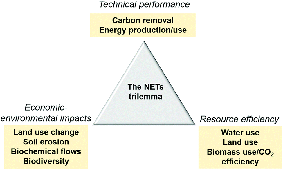 | ||
| Fig. 1 Schematic of the NETs trilemma. NETs key performance indicators are reassembled in three categories: technical performance – net CO2 removal and electricity production, resource efficiency – water, land and biomass use (equivalent to CO2 efficiency), and economic-environmental impacts – land use change and agricultural residues use (with potential impact on soil productivity and erosion). | ||
In order to position BECCS within this performance trilemma, we designed the MONET framework which comprises (1) a BECCS value chain model which calculates the water use, land use, net CO2 removed, CO2 breakeven time, net electricity produced and net CO2 efficiency of different BECCS value chains, and (2) a BECCS value chain optimisation model which determines the optimal combination of BECCS value chain configurations to meet a given CO2 removal target.
2.1 MONET value chain modelling framework
The value chain model specifically accounts for biomass cultivating, harvesting, pelleting, transport to a given region and conversion in a pulverised combustion plant combined with post-combustion CO2 capture and subsequent storage in the vicinity of the power plant. The conversion technology considered is a 500 MW dedicated pulverised biomass thermal power plant, combined with post-combustion amine-based carbon capture. In a previous contribution, we evaluated the power generation efficiency of the facility at 26%HHV, including the CCS energy penalty.4The value chain configurations are characterised by distinct:
• Biomass feedstock, b: miscanthus, switchgrass and short rotation coppice willow as archetypal dedicated energy crops, and wheat straw as an archetypal agricultural residue,
• Sub-region, sr, from which the biomass is imported: Brazil, China, EU, India and the USA are considered as potential regions of import, and discretised at the state/province level, resulting in 170 potential cells for biomass farming. Each cell is defined by its area and the position of its centroid.
• Land type, l, on which the biomass is grown: cropland, grassland, forest and marginal land. The different land scenarios are included to account for direct (LUC) and indirect (ILUC) land use change, i.e., the direct and indirect CO2 emissions associated with the conversion of a certain land type to bioenergy production. Different types of land are associated with distinct LUC and ILUC, and the resulting emissions are highly dependent on the biomass type, economic use of the land, region, timeframe considered, etc. As a simplification in this study, LUC and ILUC values, within a range of uncertainty, are attributed to the different land types, regardless of the region and biomass type. It was therefore considered that no LUC/ILUC was attributed to marginal land, medium LUC and high ILUC were attributed to cropland and grassland, as using these managed lands means an activity must be re-allocated elsewhere, and high LUC and no ILUC were attributed to forests. Converting a low vegetation land such as a marginal land, to a managed bioenergy crop with deep rooted perennial grasses, could result in negative land use change, i.e. net soil CO2 sequestration.38,39 While these effects could improve BECCS CO2 balance, we adopted the conservative approach of not considering them, given the uncertainty around their amplitude and permanence.
• Port, p, which is used for shipping the biomass from its region of origin to the region of conversion and sequestration. Each sub-region sr has access to a port p as long as there is a road access to this port.
A schematic of the current bio-geo-physical map of the MONET model is presented in Fig. 2, including the ports and biomass collection points.
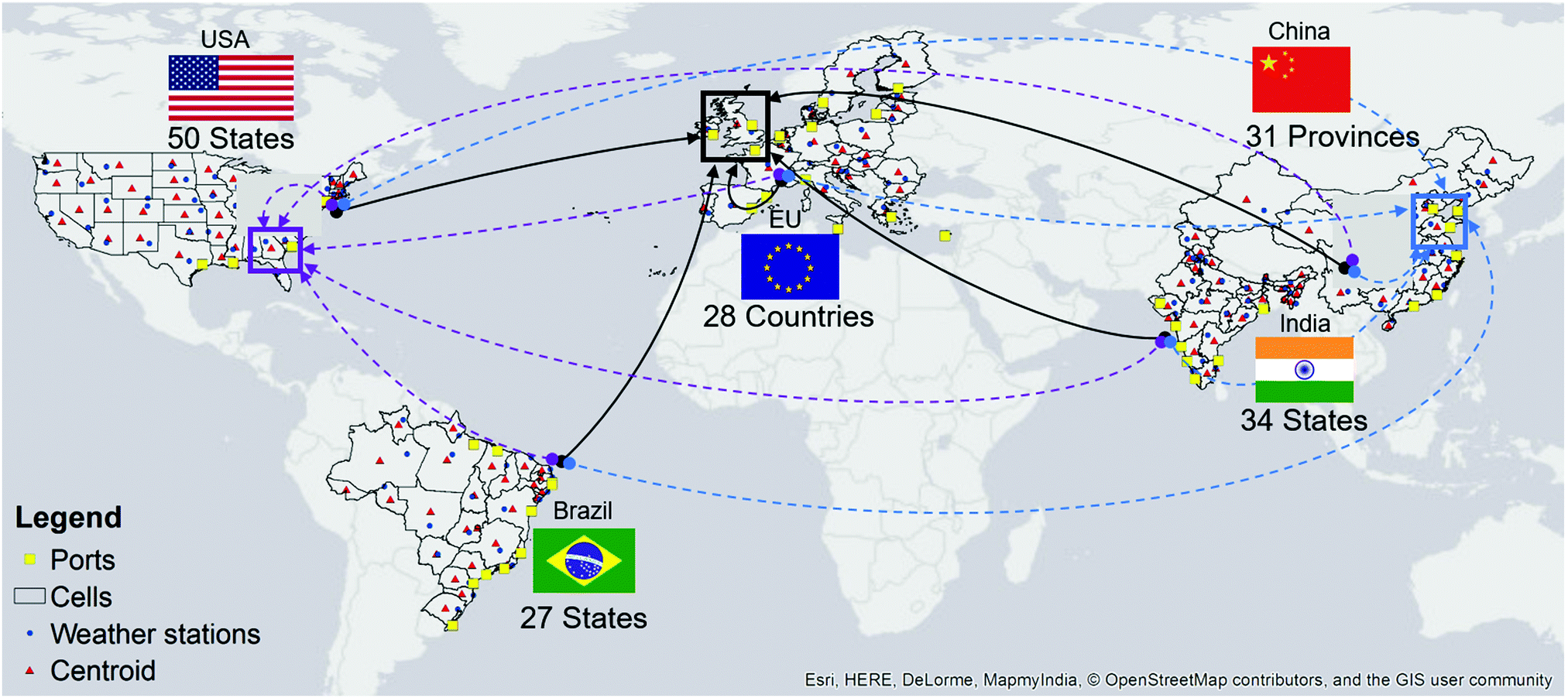 | ||
| Fig. 2 Representation of the sub-regions sr (or cells) and ports p considered for BECCS value chain modelling in MONET. Each cell is defined by its area and the position of its centroid, which were calculated using ArcGIS 10.5.40 The map also displays the location of the weather stations, indicated by the blue dot in each cell, and obtained from the software CLIMWAT 2.0,41 from which the climate data of each sub-region was collected. As an example in this figure, biomass can be shipped to the UK (black arrows), southern USA (purple arrows) and eastern China (blue arrows) for conversion and CO2 sequestration. | ||
2.2 Spatial discretisation and transport distance
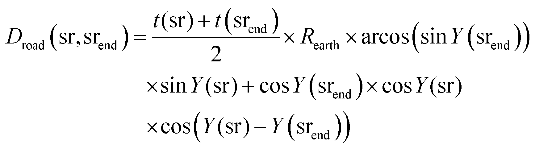
Building on our previous work,3,4 the level of spatial discretisation was increased from the macro-region level – Brazil, China, EU, India, USA – level to the province/state level – Brazilian, Indian and US states, Chinese provinces, EU countries. A consequence of this discretisation in a change in the computation of the road distance for biomass pellet transport. Sub-regions are polygons represented geographically by the latitude Y(sr) and longitude X(sr) of their centroid. Similarly, ports are represented by their latitude YP(p) and longitude XP(p). Three options are considered for biomass transport from a sub-region, sr, where biomass is produced, to a sub-region, srend, where biomass is converted into energy and CO2 is stored: (1) road transport by heavy duty vehicles (HDV) if there is a road access between sr and srend, (2) a combination of road and sea transport by container ship, (3) and short distance transport (50k) by HDV if sr and srend are the same regions. For simplicity, rail and barge are not considered in this analysis. The optimal transport route – option (1), (2) or (3), and optimal ports p and pend in option (2) – is determined by the optimisation program. The road distance considered in the model is therefore the euclidian distance between sr and srend in (1), and the summation of the euclidian distance between sr and p and between srend and pend in (2), corrected by a region-specific tortuosity factor t(sr):Droad(sr,p) = t(sr) × Rearth × arcos(sin![[thin space (1/6-em)]](https://www.rsc.org/images/entities/char_2009.gif) YP(p)) × sinY(sr) + cosYP(p) × cosY(sr) × cos(X(sr) − YP(p)) YP(p)) × sinY(sr) + cosYP(p) × cosY(sr) × cos(X(sr) − YP(p)) | (1) |
| tDroad(sr,srend,p,pend) = Droad(sr,p) + Droad(srend,pend) | (2) |
 | (3) |
2.3 Key outputs of the modelling framework
In order to solve the optimisation model, the following outputs are obtained with the value chain modelling framework, for each sub-region sr, biomass b, port p, and land type l:• WUCO2(sr,b,l,p) is the water required to remove 1 ton of CO2 from the atmosphere, in m3 per tCO2. The MONET tool calculates the water intensity of BECCS by adding three terms: the blue, the green and the grey water. In our model, the green water is considered to be the crop water demand which is met by precipitation, whereas the blue water is the additional amount of fresh water required to grow the biomass, and in the power plant. The grey water is the amount of polluted water resulting from the fertiliser use at the field level.4 In order to only account for the marginal amount of water required for BECCS, WUCO2(sr,b,l,p) only includes the blue and grey water contributions. In the case of biomass residues such as wheat straw, the blue water associated with straw production is allocated to the production of wheat, and therefore considered to be zero.
• PPLUCO2(sr,b,l,p) is the amount of land used by BECCS facilities to remove 1 ton of CO2, in ha per tCO2.
• FLUCO2(sr,b,l,p) is the amount of land harvested for biomass at the field level per ton of CO2 removed, in ha per tCO2. In the case of biomass residues such as wheat straw, the land footprint associated with straw production is allocated to the production of wheat, and therefore considered to be zero for straw.
• NECO2(sr,b,l,p) is the amount of net electricity produced in GJ per ton of CO2 removed, accounting for the energy cost of BECCS value chain. The approach used to calculate this metric has been presented in detail previously,3 and is not repeated here.
• BUCO2(sr,b,l,p) is the amount of biomass used to remove 1 ton of CO2 from the atmosphere, in tDM per tCO2.
• BioC(b) is the biomass carbon content in %DM.
• CNCO2(sr,b,l,p) is the cumulative net amount of CO2 stored by a BECCS configuration, over its lifetime, per hectare of land, in tCO2 per ha.
• CNE(sr,b,l,p) is the cumulative net amount of electricity produced by a BECCS configuration, over its lifetime, per hectare of land, in MJ per ha.
• BETCO2 is the CO2 breakeven time of the BECCS configuration, i.e., the time required for the system to be carbon negative.
• BETE is the electricity breakeven time of the BECCS configuration, i.e., the time required for the system to be energy positive.
2.4 Supply chain optimisation framework
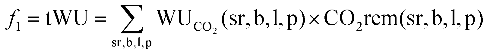
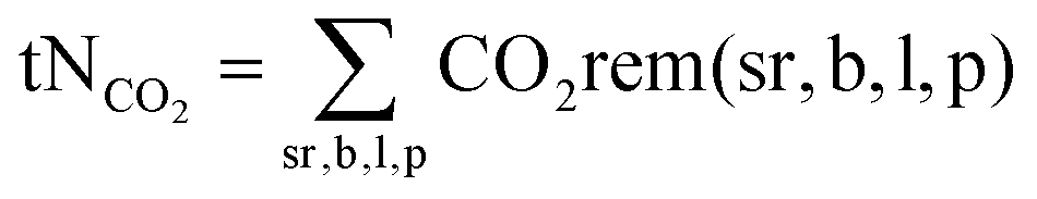
The purpose of this work is to determine the optimal BECCS value chain required to remove 50 MtCO2 per year in a given region, by allocating the amount of CO2 removed annually per configuration CO2rem(sr,b,l,p) while minimising or maximising different objective functions [f1,f2,f3,f4]:• Minimisation of total water use tWU:
 | (4) |
• Minimisation of total land use tLU which accounts for the harvested land in region sr, and the land used by the BECCS facilities:
| f2 = tLU = tFLU + tPPLU | (5) |
Similarly to fresh water use, the cultivated land associated with the production of wheat straw is allocated to wheat production. Wheat straw land footprint at the field level is therefore not accounted for in the summation:
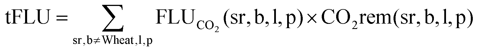 | (6) |
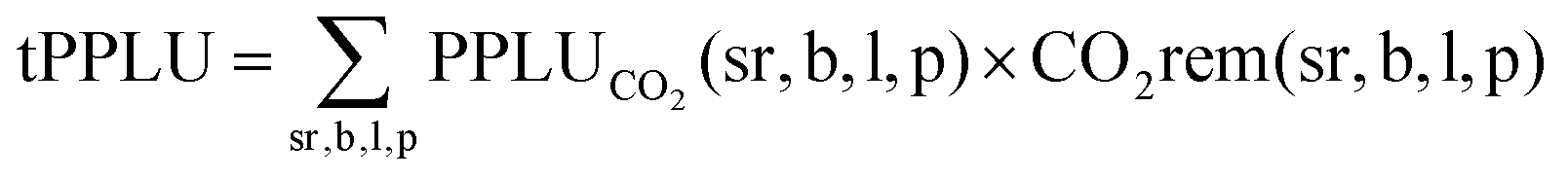 | (7) |
• Maximisation of the total CO2 efficiency tηCO2, i.e., the ratio of the amount of CO2 permanently removed tNCO2 to the amount of CO2 stored in the biomass, tBioCO2. The latter is directly related to the amount of biomass used:
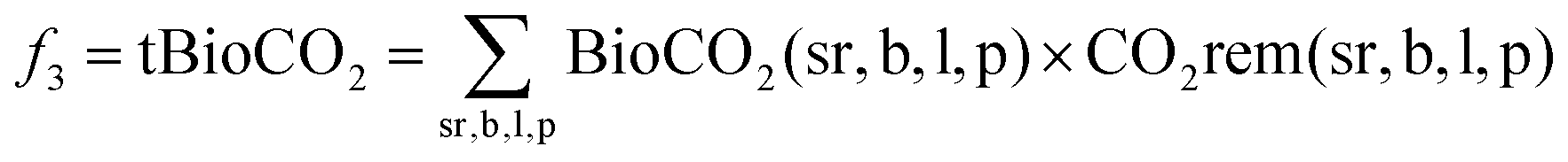 | (8) |
| BioCO2(sr,b,l,p) = BUCO2(sr,b,l,p) × BioC(b) × CtoCO2 | (9) |
 | (10) |
 | (11) |
As the total amount of CO2 removed is fixed, maximising tηCO2 is equivalent to minimising tBioCO2. As tηCO2 is an nonlinear variable, tBioCO2 is thus minimised to ensure the linearity of the model. It is worth noting that minimising the total amount of CO2 stored in the biomass is equivalent to minimising the total amount of biomass used.
• Maximisation of the net electricity produced tNE by the BECCS value chain:
 | (12) |
The preference-based procedure of using a weighted sum of the different objectives as a unique objective function was not used here for two reasons. First, the inherent diversity of the different objectives – land use, water use, CO2 efficiency and net energy produced – make them complex to convert into one single objective. Secondly we estimated that preference of one objective over the others will be highly region specific, and choosing these factors arbitrarily could therefore give irrelevant results as to BECCS optimal value chain. Therefore, in the first instance, we chose to treat each of these objectives separately, and leave the multi-criteria, multi-stakeholder problem for future work. Thus, we have formulated four distinct scenarios which allow us to perform a series of thought experiments across the BECCS value chain. These four optimisation scenarios are subject to the following constraints:
• The configurations considered must be carbon negative within a relevant time-frame, i.e., the BETCO2(sr,b,l,p) must be smaller than the project lifetime, considered to be 50 years in this analysis:
| BETCO2(sr,b,l,p) ≤ 50 | (13) |
This constraint is equivalent to CNCO2(sr,b,l,p) being positive:
| CNCO2(sr,b,l,p) ≥ 0 | (14) |
• The amount of net CO2 removed annually by the configuration, CO2rem(sr,b,l,p) must be positive:
| CO2rem(sr,b,l,p) ≥ 0 | (15) |
• In a first instance, we also constrained the configurations to be energy positive:
| BETE(sr,b,l,p) ≤ 50 | (16) |
| CNE(sr,b,l,p) ≥ 0 | (17) |
As electricity production is not the primary service delivered by BECCS, this constraint may be relaxed if the optimisation problem cannot solve.
• The total amount of CO2 removed must be equal to the set CO2 removal target:
| tNCO2(sr,b,l,p) = CO2 target | (18) |
• The amount of land harvested in each region for dedicated energy crops is limited by the availability LA(sr,l) of land type l in sub-region sr:
 | (19) |
• Though no land footprint is attributed to wheat straw production, the amount of harvested land for wheat is each region is limited the wheat area availability WA(sr) in sub-region sr:
 | (20) |
To evaluate the extent of land use change under each optimisation scenario, the variable tLUC is calculated as the summation of all land types other than marginal land – i.e., cropland, grassland and forest – used for the production of dedicated energy crops:
 | (21) |
2.5 Pareto-front analysis
The ε-constraint method was used to quantitatively evaluate the trade-offs between the four objective functions. For each combination of objective functions, fj and fk, the following optimisation problem was solved:| min fj | (22) |
| s.t. fk ≤ εmk ∀k ≠ j | (23) |
2.6 Data curation
The model input data at the macro-region level has been reported in detail in previous contributions.3,4 However, biomass yield, climate data, and carbon intensity of electricity were desegregated at the state/province level. Ports and centroid locations, as well as distances between ports were also added. Furthermore, data related to land availability constraints, such as land cover (forest, grassland and cropland), marginal land availability and harvested wheat area were added to the model. The software ArcGIS40 was used to process datasets obtained from the literature, and, aggregate the different values at the sub-region level. Fig. 3 illustrates three potential BECCS value chains for CO2 storage in the UK, with key regional input data such as biomass yield, CO2 intensity of the electricity, marginal land area and wheat harvested area. In a UK case study, though using domestic pellets would minimise the pellets' transport distance to the BECCS facility, factors such as the regional electricity carbon footprint, which significantly affects the carbon intensity of biomass pelleting activities, precipitation, which impacts biomass water footprint, biomass yield, which has multiple impacts on the value chain, or marginal land and wheat straw availability, which constraints the amount of BECCS that can be deployed without causing land use change, can be determining in the design of BECCS optimal value chain.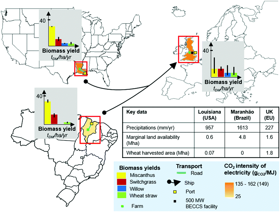 | ||
| Fig. 3 Illustration of three potential BECCS value chain to a UK-based BECCS facility: using domestic pellets, which minimises transport distance, or importing pellets from Louisiana (USA) or Maranhao (Brazil). Factors such as carbon intensity of electricity, precipitation, biomass yield, marginal land area and wheat harvested area are paramount when determining BECCS optimal value chain. | ||
• Yield data: yield data for different regions of the world were collected for each dedicated energy crop from the literature. When available, yield datasets with high regional discretisation were used.27,43 When the yield data of a sub-region sr was unknown, the yield of the sub-region with the closest climate conditions, according to the Koppen Climate Classification44 was used. Wheat grain yield was obtained at the country level from the FAO.41 Low, median and high yields of each biomass type are provided in Tables 5–7 in Appendix A.
• Land cover: in order to determine the total cropland, grassland and forest area available in each sub-region sr, the MODIS global land cover with a spatial resolution of 15 arc second geographic was used.45Tables 2–4 in Appendix A provide the land cover per cell adapted from the MODIS database. Forest area was calculated summing Evergreen/Deciduous Needleleaf/Broadleaf forests with the mixed forest categories. Grassland and cropland land cover were directly obtained from the land cover categories.
• Marginal land area: in order to use a consistent dataset for all regions, the marginal land dataset from the Cai et al.21 study was used in this work. As a conservative approach, and to be consistent with other literature sources, only the lower bounds values (S1) from this study were considered. Similarly to land cover and wheat harvested area, the 30 arc second resolution raster file was processed to obtain the marginal land area in each sub-region, sr. Data is supplied in Tables 2–4 in Appendix A.
• Wheat harvested area: in order to constrain the amount of wheat straw available per region, the map of the world wheat harvested area with a spatial resolution of 5 minute geographic, obtained from the SPAM model,46 was processed in ArcGIS40 (Tables 2–4 in Appendix A). It is worth noting that the harvested area per cell can be greater than the cell size, in the case of multiple harvests per year.
• Road tortuosity: the road distance was computed using euclidian distance, corrected by a tortuosity factor. Approximate tortuosity factors were computed for each sub-region sr, by dividing the road distance of the centroid to the nearest port, by the euclidian distance between these two points. Computed tortuosity factors are provided in Tables 5–7 in Appendix A.
• Median scenario: the average values of all parameters are used for the calculations,
• Low scenario or “Optimistic” scenario: values which minimise the water, land, CO2 and energy intensities of BECCS value chain are used to perform the calculations. Lower bound values of the land use change emissions, biomass moisture content, carbon and energy intensities of chemicals and input products, fertiliser and chemical input rates, processing energy requirements, electricity carbon footprint, average power generation of the electricity are used. However, upper bound values for biomass yield per region, biomass energy density and biomass carbon content are used.
• High scenario or “Pessimistic” scenario: values which maximise the water, land, CO2 and energy intensities of BECCS value chain are used to perform the calculations. Upper bound values of the land use change emissions, biomass moisture content, carbon and energy intensities of chemicals and input products, fertiliser and chemical input rates, processing energy requirements, electricity carbon footprint, average power generation of the electricity are used. However, lower values for biomass yield per region, energy density and carbon content are used.
To avoid including additional degrees of freedom to the model, no range of uncertainty or variability was implemented for marginal land availability, harvested wheat area, land cover, road tortuosity and climate data. Quantifying the impact of uncertainty in MONET was the focus of a previous contribution.4 To assess the impact of the uncertainty of the model input data, thorough stochastic modelling would need to be performed. We leave this for future work.
2.7 Measuring BECCS impact on agricultural residues and land use change
In order to investigate BECCS economic-environmental impacts, three impact scenarios were considered in the optimisation framework:• Scenario I: BECCS is only deployed via dedicated energy crops (DEC) grown on marginal land (MAL). Under this scenario, BECCS deployment does not cause land use change, and does not compete with other uses of agricultural residues (AR).
• Scenario II: BECCS is deployed via dedicated energy crops grown on marginal land and agricultural residues from cropland. BECCS economic-environmental impacts are limited to the use of agricultural residues.
• Scenario III: BECCS is deployed via dedicated energy crops from all land types, and agricultural residues from cropland. Under this scenario, BECCS deployment might compete with other markets and cause substantial land use change.
3 BECCS optimal value chain in the water–land–carbon nexus
In a first instance, this section presents different insights from the optimisation of the BECCS value chain required to remove 50 MtCO2 per year in the UK, under three different objective functions – water minimisation, land minimisation, and CO2 efficiency maximisation, considering only DEC on MAL (I). To illustrate that the modelling framework can also be applied to meet other regional targets, this section includes the BECCS optimal supply chains required to meet US and China carbon removal targets, by storing CO2 in southern USA, and in Eastern China, respectively.3.1 The optimal structure of BECCS value chain
Fig. 4 presents the selected regions, ports, as well as marginal land use density in each cell (fraction of the total land used by BECCS), biomass pellets transport fluxes (arrows) and amount of net CO2 removed per region for each objective function, in the median, optimistic and pessimistic data scenarios, to meet a UK target (black arrows). The coloured arrows illustrate how these optimal value chains may change as the location of the BECCS facility and CO2 storage, and therefore the biomass transport distance, changes for the US (purple arrows) and China (blue arrows). A first conclusion in that the structure of the optimal BECCS value chain changes substantially depending on which metric is prioritised. Under the water minimisation scenario, represented in Fig. 4a, factors such a climate conditions, precipitation and yield play a central role in the water performance of each combination. In spite of substantial road and sea transport distance, regions from western and central Brazil are selected, owing to their combination of low carbon intensity of their electricity and high biomass yield, which highlights the strong trade-offs between transport and other supply chain parameters. As seen in Fig. 4b, when minimising land use, yield and supply chain emissions have a strong impact on the results, and productive coastal regions from Brazil are selected. Similar results are obtained in the CO2 efficiency maximisation scenario (Fig. 4c), though domestic biomass is also selected in the balance to minimise CO2 leakage from transport. When changing the CO2 storage location from the UK to Southern USA or Eastern China, the change in biomass transport distance significantly changes the optimal configuration in the carbon efficiency maximisation scenario, in which biomass transportation represents an important share of the overall CO2 leakages along the chain. However from a water and land minimisation perspective, the optimal regions do not change significantly, which further confirms the low weight of transport distance as compared to other more prevalent factors, when it comes to resource conservation. | ||
| Fig. 4 BECCS optimal supply chain to minimise global water use (a), land use (b) and CO2 efficiency (c) in the median, optimistic and pessimistic scenario. There are strong trade-offs between the resource efficiency indicators: water increases threefold from the water minimisation to the CO2 maximisation scenario. Overall, biomass from regions with higher yield, lower grid carbon intensity and higher precipitation is chosen over indigenous biomass. Changing the storage location from the UK to Southern USA or Eastern China brings significant changes to the optimal configuration in the CO2 maximisation scenario, where transport plays an important role, but limited changes to the water and land minimisation configurations. | ||
These results were also found highly dependent on the model input data. As regional yield, fertiliser use, and carbon footprint of the electricity change from the median to the optimistic scenario, thereby decreasing regional pellets' water and carbon footprints, other regions such as northern Europe are selected in the water minimisation scenario. In the land minimisation scenario, miscanthus from the US east coast and southern Europe is selected. This is highly dependent on the yield range considered for each region. In the CO2 efficiency maximisation scenario, a balance of Miscanthus from UK and Brazil are also selected in the optimistic and pessimistic scenarios.
The trade-offs between these resources can be assessed by evaluating the total land use, water use, and biomass use under the three optimisation scenarios, which are also represented in Fig. 4. It is observed that water use, and to a smaller extent land use and CO2 efficiency, are highly dependent on which metric is optimised. Water use increases threefold in the CO2 maximisation scenario, as compared to the water minimisation scenario. CO2 efficiency and land use variations are less important: regardless of the optimised metric, land use remains within 1.8–2.8 Mha for all scenarios, and CO2 efficiency, within 48–54%. The trade-off between CO2 efficiency and land use is less extreme: in the pessimistic scenario, the supply chain required to minimise the land use is the same as the one required to maximise the CO2 efficiency.
The structure and the resource efficiency of BECCS optimal value chain are therefore very dependent on the objective function and parameters such as yield, fertiliser rate, climate and grid carbon intensity. Accurate weighing of each metric is required to determine an optimal BECCS value chain which reconciles all three metrics. Understanding which mechanisms might influence such decisions is therefore key to deploy BECCS optimally. Access to accurate data for the key model input parameters is also crucial.
3.2 Trade-offs within the water–carbon–land nexus
Trade-offs between the objective functions were quantitatively evaluated using the ε-constraint method, and pareto-fronts between each objective functions were generated. Fig. 5 shows the pareto curves between f1, f2 and f3 in the median, optimistic and pessimistic scenarios.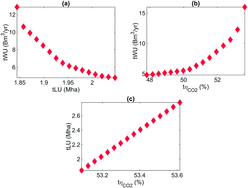 | ||
| Fig. 5 Pareto lines between water use, land use, and CO2 efficiency, in the median scenario. There are strong trade-offs between water use and the other two objective functions. However, the trend of the pareto lines for these two relations ((a) and (b)) indicate the presence of tipping points which could reconcile the different objectives. CO2 efficiency decreases marginally when land use increases, showing the proximity of these two optima. | ||
As discussed in Section 3, the pareto lines in Fig. 5 indicate a strong trade-off between water use and the two other objective functions. When minimising water use, as total land use in constrained from 2.05 Mha to 1.85 Mha, water use increases from 5 to 13 Bm3 per year. Moreover, as carbon efficiency is constrained from 48% to just under 54%, water use increases threefold. However, the shape of the pareto lines indicate the presence of tipping points: beyond 1.95 Mha and 50.1% efficiency, the rate of increase in water use significantly increases. In the case of land use against CO2 efficiency, it is difficult to identify a tipping point, as the relationship is linear. However, the variation of the CO2 efficiency is very limited for a given variation of land use, which shows that the optimal points are closed for both optimisation scenarios. This analysis shows the complex interactions between BECCS resource efficiency indicators. Deploying BECCS such that each indicator is maintained close to the tipping point, rather than optimised, could be a preferred option to maximise BECCS overall resource efficiency.
4 Sensitivity analysis
4.1 Limiting supply
As pointed out in the introduction, reliably quantifying the availability of marginal land is complex owing in part to the diversity in definitions, methodologies and datasets used. In 2013, Fritz et al. downgraded Cai et al. lower bound estimates by 69%, bringing the total marginal land availability from 320 Mha to 98 Mha.22 Whilst the availability of agricultural residues can be evaluated with more certainty, determining which fraction of the residues is both recoverable from the field, and used for bioenergy without competing with other uses – for e.g. soil enriching or fodder, is not straightforward. In a recent study on biomass production potential from Brazil,47 the author evaluated the harvestable proportion of agricultural residues to be below 50%, and the proportion of harvested resource available for bioenergy, below 10%. Owing to this complexity, we use this section to study the impact of constraining the availability of marginal land and agricultural residues on the total land use and total land use change in our various scenarios. Fig. 6 shows the evolution of the total land use tLU in the land minimisation scenario, and the total land use change tLUC for the three objective functions, as a function of marginal land and crop residues availability, in the impact scenario III. Fig. 6a shows that the availability of residues plays a first order role in the system's total land use. When it is limited to 20%, total land use increases by several orders of magnitude. This can be explained by the fact that no land use at the field level, nor CO2 emissions from farming, except from the additional fertiliser cost resulting from the removal of the residues from the field, were attributed to agricultural residues, as opposed to dedicated energy crops. As a grey water footprint is attributed to crop residues because of this additional fertiliser use, water use is decreased to a smaller extent. As far as land use change is concerned, when minimising land use and maximising the CO2 efficiency, land use change only occurs when AR availability is limited below 20%. When minimising water use however, land use change can be high even in high marginal land availability. Though land use change results in higher lifecyle CO2 emissions, as long as the water consumption per CO2 removed is still attractive, bioenergy crops planted on former cropland and grassland may still be preferable in the water minimisation scenario. This indicates the presence of trade-off between carbon removal and water use.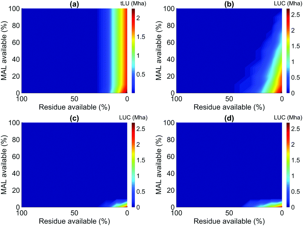 | ||
| Fig. 6 Total land use in the land minimisation scenario (a), and land use change in the water minimisation (b), land minimisation (c) and CO2 efficiency maximisation scenarios, in impact scenario III. Residue availability has a first order impact on BECCS total land use. When minimising land use and maximising the CO2 efficiency, land use change only occurs when AR availability is limited below 20%. When minimising water use however, land use change can be high even in high marginal land availability: there is a greater trade-off between carbon removal and water use. | ||
To provide further insight into this emergent behaviour, Fig. 7 illustrates the evolution of BECCS optimal value chain in the water minimisation scenario at 0% residue use availability, and constraining marginal land availability from 100% to 10%. As marginal land availability decreases, it is interesting to see that the same regions from Brazil are used, but both the amount and proportion of grassland and cropland used increase, as well as the land use density. Other regions that had not been selected before, such as China, also start appearing in the results when land availability is drastically constrained, supporting the conclusion that the nearest regions are not necessarily the optimal regions from a water perspective.
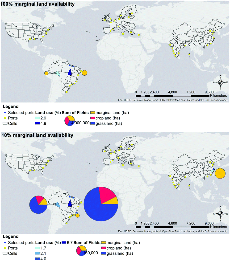 | ||
| Fig. 7 Evolution of BECCS optimal value chain in the water minimisation scenario at 0% AR availability, and constraining marginal land availability from 100% to 10%. | ||
This study has provided insight into the important trade-offs between BECCS resource efficiency and economic-environmental impacts. It was shown that using agricultural residues could drastically relieve BECCS pressure on land use. In order to obtain the same result while avoiding competition with other uses of agricultural residues, using high productivity-high carbon content biomass such as algae, could be a promising alternative.48 A second important trade-off exists between water use and land use change: minimising water use for BECCS might result in high land use change, particularly when the availabilities of marginal land and crop residues are constrained. This conclusion builds upon the previous contribution of Heck et al.,5 where this potential compromise was first alluded to. This further confirms that myopic focus on the trade-offs between BECCS environmental and economic performance is, at best, incomplete: there are complex interactions within BECCS environmental trade-offs which must be understood in order to deploy BECCS in a genuinely environmentally and ecologically benign manner.
4.2 Ramping up the carbon removal target
Though the UK projects a 50 MtCO2 per year, it is conceivable that more CO2 might be stored in the UK for two reasons: (1) the UK's own target might increase over the course of the century,35 and (2) as regional storage availability is limited, other regions could be willing to store CO2 in the UK as well. As a thought experiment, we investigate how ramping up the targeted amount of CO2 to be stored in the UK impacts the key performance indicators of BECCS value chain under the three optimisation and impact scenarios. The resulting water use under the water minimisation scenario (a), land use under the land minimisation scenario (b), CO2 efficiency under the CO2 efficiency maximisation scenario (c), and total land use change in all three optimisation scenarios, in the impact scenario III, are presented in Fig. 8.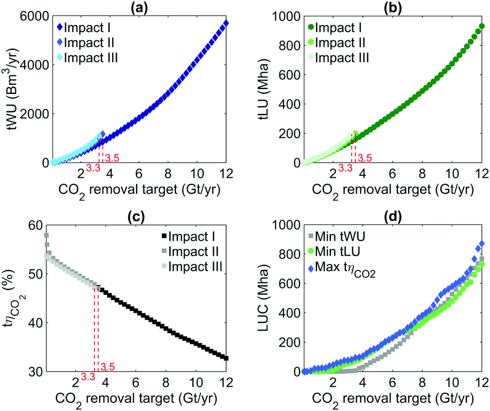 | ||
| Fig. 8 Minimal water use (a), minimal land use (b), maximal CO2 efficiency (c) under impact scenario I (DEC on MAL), II (DEC on MAL and AR) and III (all land types, all crops) and land use change in impact scenario III under the three optimisation scenario (d). | ||
Two insights can be derived from this thought experiment. First, the median world scale carbon dioxide removal can only be met in the impact scenario III, i.e., when BECCS is deployed on all types of land and using crop residues in addition to dedicated crops. As observed in Fig. 8, by limiting bioenergy sourcing to dedicated energy crops from marginal land, up to 3.25 GtCO2 per year can be removed by deploying BECCS and storing the CO2 in the UK (a). Adding residues (b) – wheat straw in this study, only marginally increases BECCS carbon removal capacity, which reaches 3.5 GtCO2 per year. Naturally, expanding the MONET framework by implementing other regions – Africa, Russia, Indonesia, Australia, in MONET, as well as climate-tailored biomass crops and agricultural residues would increase this carbon removal potential and nuance this statement. For example, in 2016, a total of 770 Mt of corn was produced by the five regions considered in MONET.49 Assuming a grain to corn stover ratio of 1:1,50 a carbon content of 48%, the same carbon efficiency as using local wheat straw pellets (63% CO2 efficiency, no long distance transport), and that all corn stover is available for BECCS, 850 additional MtCO2 could be removed from the atmosphere. This being noted, this thought experiment shows the potentially negative economic-environmental impacts associated with BECCS deployment at the gigatone scale.
Secondly, resource mobilisation and land use change increase exponentially with the CO2 removal target. Removing 12 GtCO2 per year would require at the minimum 5700 Bm3 per year, 930 Mha, and producing at the maximum 35 TJ per year (net) at a maximum CO2 efficiency of 33%, which, for comparison, is in the upper range of BECCS resource use in the literature. Smith et al.8 evaluated a land requirement of 380–700 Mha, and a marginal water requirement, as compared to the water consumption of a counter factual scenario, of 720 Bm3 to meet a 12 GtCO2 per year target. In Heck et al.,5 removing 5 GtC per year with bioenergy, resulting in a net removal of 8 to 10 GtCO2 per year depending on the CO2 efficiency of the process, requires between 1000 and 4000 km3 of blue water use (no grey water considered), depending on the weighting of the objectives in the objective function. This shows that though more CO2 storage might be available in the UK, there is a limit beyond which CO2 storage in the UK is no longer resource nor CO2 efficient, which confirms the need for multi-polar systems when deploying negative emissions at the gigatone scale.
5 Energy production or resource conservation?
In the final section of this paper, we focus on the technical element of the trilemma, i.e., BECCS net electricity production potential. Fig. 9 presents the total water use (a), land use (b), CO2 efficiency (c), net electricity produced (d) and land use change (e) in the four optimisation scenarios, in the impact scenario I.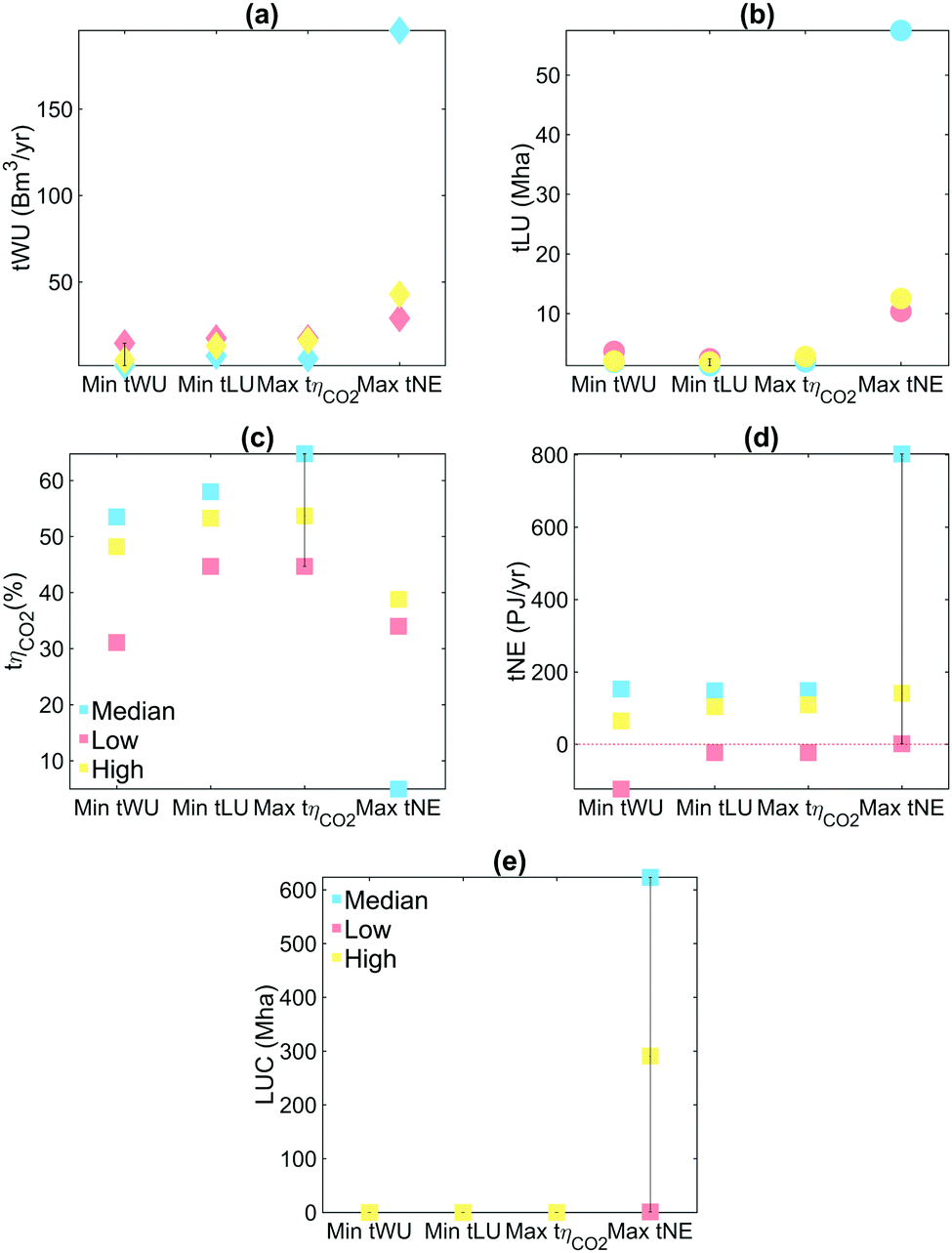 | ||
| Fig. 9 Total water use, land use, and CO2 efficiency, in scenario I, and land use change (scenario III) under four objective functions, in the median, pessimistic and optimistic scenarios. Energy maximisation presents much stronger trade-offs with the other metrics: to maximise energy the ratio of energy production per CO2 removed needs to be maximised, which results in a high water use, land use, low carbon efficiency and land use change. Only focusing on energy production and negative emissions is detrimental to BECCS environmental performance. | ||
It is observed that energy maximisation presents much stronger trade-offs with the other metrics: water use and land use increase fivefold, land use change by two orders of magnitude, and CO2 efficiency decreases by 13 efficiency points, when maximising electricity production. This can be explained by the fact that, in order to maximise electricity production at a fixed CO2 removal target, the ratio of energy production per amount of CO2 removed needs to be maximised. This leads to the selection of regions featuring a high net electricity production, and/or a low net CO2 removal, i.e., in the latter, regions that are inefficient at removing CO2 from the atmosphere. This results in a high water use, land use and low carbon efficiency. Another interesting insight from this analysis is that in the pessimistic scenario, the system cannot be net electricity positive.
All of these results highlight the strong trade-offs between net electricity production and CO2 efficiency, which is consistent with other studies in the literature.3–5,51,52 In these studies, it was shown that BECCS services – CO2 removal and electricity production – mutually exclude each other. However, this contribution takes the analysis further by showing that the duality is not only between electricity production and CO2 removal, but for a given CO2 removal target, between electricity production and BECCS land use, water use, CO2 efficiency and land use change. One should therefore consider all of BECCS' KPIs when designing its supply chain, as focusing only on BECCS main services – CO2 removal and electricity production – can ultimately counteract the ostensible positive environmental impact of BECCS.
Taking this point further, one can postulate the existence of a global BECCS supply chain which can satisfy both BECCS' energy production objectives and resource use constraints. Annual negative emissions requirements between 1.8 to 9.9 GtCO2 by 2050 have been predicted by integrated assessment models in order to maintain a 2 °C trajectory with median values around 7 GtCO2 per year.5,53 Projections of primary energy delivered by BECCS in 2050 can be found between 35 and 120 EJ per year depending on the scenario, with an average around 80 EJ per year.11,54,55 By removing 50 MtCO2 per year in 2050, the UK would therefore be contributing to approximately 0.7% of the world CO2 removal target. Assuming that the UK would remove CO2 efficiently from the atmosphere, only 0.7% of the world marginal land available could therefore be mobilised to meet the UK CO2 removal target. Using the 390–1107 Mha from Cai et al.,21 the UK could therefore reasonably use up to 2.2–7.8 Mha of marginal land. By this contribution to global negative emissions, the UK should also theoretically supply 570 PJ per year of primary energy, or generate approximately 170 PJ per year of electricity. The droplets on Fig. 10 represent the total electricity generated tE for different land constraints, under the energy maximisation scenario. Land use is separated in three zones: the “safe” zone in green, where land use is constrained to 2.2 Mha, the uncertainty zone in yellow, where land use is constrained under 7.8 Mha, and the forbidden zone in red. The system's total water use is represented by the colour scale, and the total biomass use, by the size of the droplets. Energy production in the water, land and biomass minimisation are also represented for comparison by the triangles.
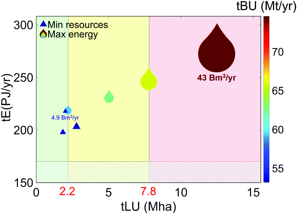 | ||
| Fig. 10 BECCS total electricity generated under different land constraints, in the energy maximisation scenario (droplets), and the water, land and CO2 efficiency minimisation and maximisation scenarios (triangles). Water use is represented by the colour scale, and biomass use, by the markers' size. Even when land use is constrained to a “safe” value (green zone), the UK electricity generation objective consistent with a 50 MtCO2 per year target is met. | ||
Fig. 10 shows that, even while maintaining the total land use in a “safe” zone (i.e., inferior to 2.2 Mha), BECCS electricity production objective is met; the markers are outside of the grey area. Though maximising energy production drastically increases water, land and biomass use, it is nevertheless possible to reconcile BECCS energy generation objective with land use constraints. Similarly, the triangles representing the water, land and CO2 efficiency minimisation and maximisation are also located in, or close to, the safe zone. Though there may be strong trade-offs between these resource efficiency indicators, they are all compatible with a safe land use.
6 Relevance to policy makers
In this study, we have identified the complex interactions existing between BECCS technical and environmental performance indicators. Assessing BECCS systems from a marginal cost per ton of CO2 removed would therefore be incomplete. In particular, the strong trade-offs between water use and land use change, as well as between energy production and all of BECCS impacts, showed that one cannot optimise these systems from the perspective of a unique environmental impact. A sustainability standard which does not only regulate biomass maximum carbon intensity, but also BECCS water, land and CO2 efficiencies, as well as land use change, will be required to ensure that BECCS is deployed within sustainable boundaries.Growing perennial grasses on marginal land, whilst sustainable, might not be practical.56 Actively engaging and incentivising all stakeholders of BECCS value chain, including farmers, will be crucial in unlocking BECCS deployment.
Furthermore, in meeting a regional carbon removal target, the prevalence of imported biomass in the optimisation results highlighted the preeminence of parameters such as yield, CO2 intensity of electricity, and climate data, over transport distance. Regions with good compliance with these parameters were repeatedly selected regardless of the CO2 storage location. One implication of this is that BECCS policy frameworks will need to consider the logistics, and negative emissions accounting of a system where regions meet their carbon removal target with imported biomass. Another implication of this is, were CO2 storage to be available in regions providing sustainable biomass, for example Brazil in this case study, a potentially important share of the global carbon removal target could be achieved by a 100% Brazilian BECCS value chain. How much of the world carbon removal target could be met with this value chain, as well as the potential environmental and economic trade-offs between local and international value chains, are important research questions to tackle. If we take this thought experiment further in the context of meeting a global CO2 removal target, it is conceivable that a region A meets its target using biomass feedstock from a region B to store CO2 in a region C. Integrating the multi-polarity of negative emissions in the design of policy frameworks will likely be a crucial policy challenge for BECCS. Implementing different CO2 storage sites, as well as a CO2 transport and storage value chain model, into MONET, is however required to investigate these challenges further.
7 Conclusions
In this contribution, we have presented a framework which enables the study of the complex relationship between the ability of BECCS to be net energy positive, net carbon negative, and the broader environmental impacts of large-scale deployment of this technology. In the context of determining the extent to which each NET should be deployed for efficient and sustainable CO2 removal, this framework could be applied to other NETs.By highlighting the trade-offs between BECCS resource efficiency, environmental performance and technical performance, this study shows that the design of BECCS value chain needs to be performed in the prism of all BECCS KPIs. Strong trade-offs with tipping points were identified between water use and the other two resource efficiency indicators in particular. How to build an objective function which reconcile all of BECCS' KPIs, while accounting for how BECCS performance may vary from one region to another, is therefore a key research challenge to be addressed.
Another conclusion is that, factors such as yield, carbon intensity of power, and high precipitation led to the selection of imported biomass over indigenous biomass. The design of policy frameworks considering the carbon accounting implications of using foreign biomass to store CO2 in a given region, thereby meeting this region's carbon removal target, are paramount to facilitate local BECCS deployment. What is already complex at the megatone scale becomes manifold at the gigatone scale: how to regulate systems where biomass is imported from a productive region A, CO2 is stored in region B with abundant storage, to meet the CO2 removal target of a region C, as well as how to allocate credits among these actors, are key research and policy question to be investigated.
The availability of sufficient marginal land and agricultural residues were observed to be of paramount importance to our results. However, it is also recognised that their availability is controversial, at best. To provide insight into the impact of their respective availability, a sensitivity analysis of the optimisation results to the availability of marginal land and agricultural residues was performed. A first insight from this analysis is that agricultural residues exerted a first order impact on BECCS land use; residues being attributed low agricultural carbon and water footprints, total land use decreased by several orders of magnitude when using agricultural residues. Assessing precisely how much agricultural residues could be used for BECCS, without trespassing on other uses, could drastically relieve the pressure of BECCS on land use. A strong trade-off between water use and land use change was also identified: when minimising water use, using non-marginal land from low water footprint regions, and therefore causing land use change emissions, was preferable to using marginal land from higher water footprint regions. Water use and land use change being two critical sustainability indicators for BECCS, one should therefore be careful with potential direct and indirect land use effects when deploying BECCS from a water-saving perspective, and vice versa.
When ramping up the CO2 removal target, it was found that the world median CO2 removal target of 12 GtCO2 per year was only achievable by storing CO2 in the UK when residues and all land types were considered for BECCS. It was also found that water use, land use and CO2 efficiency did not increase linearly with the CO2 removal target, as marginal land from “sustainable” regions get depleted as the CO2 target increases, thus leading to the selection of other types of land or less sustainable regions. This shows that, though the UK has the storage capacity to achieve more CO2 storage than its current target, there will be a clear trade-off between how much and how efficient carbon dioxide removal from the UK will be. This further confirms the need for multi-polar systems when deploying negative emissions at the gigatone scale. Implementing other storage sites in MONET will be required to investigate the optimal structure of the world CO2 network for carbon dioxide removal.
Finally, maximising net energy production led to a drastic increase in the system's water use, land use, and land use change, as well as a decrease in CO2 efficiency. This is explained by the fact that, at a given CO2 removal target, regions which are less efficient at removing CO2 are selected to maximise the amount of energy produced. A key insight from this result is that focusing exclusively on energy production and CO2 removal is detrimental to BECCS resource efficiency and impact on ecosystems.
As a final thought experiment, we considered the proportional share of marginal land available, to what the UK is contributing to the world global carbon removal target by 2050, as a safe land use boundary in the context of UK CO2 removal target. Were BECCS in the UK to be deployed subject to this land use constraint, it was found that BECCS electricity production objectives were still met. What this last analysis shows is that, whilst BECCS KPIs may be negatively correlated, they are, however, not incompatible: providing the right choices are made along BECCS value chain, BECCS can be deployed in a way that meets altogether its carbon removal objective, electricity production objective, and land use constraints.
Conflicts of interest
There are no conflicts of interest to declare.Appendix
A Additional data
Fig. 11.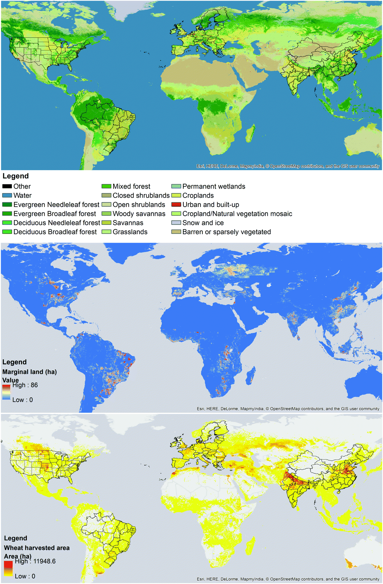 | ||
| Fig. 11 Land cover with a resolution of 15 arc second geographic, adapted from the MODIS dataset,45 marginal land area with a resolution of 30 arc second geographic, adapted from Cai et al.,21 and harvested wheat area with a resolution of 5 minute geographic, adapted from MAPSPAM.46 | ||
| Sub-region sr | Croplanda (ha) | Grasslanda (ha) | Forestsa (ha) | Marginal landb (ha) | Harvested wheat areac (ha) |
|---|---|---|---|---|---|
| a Obtained using the MODIS dataset.45 b Obtained using marginal land dataset from Cai et al.21 c Obtained using harvested wheat area from MAPSPAM.46 | |||||
| Acre | 4529 | 8744 | 14796138 |
65464 |
0 |
| Alagoas | 198379 |
104788 |
21278 |
538378 |
0 |
| Amapa | 75662 |
99536 |
12048270 |
755909 |
0 |
| Amazonas | 42148 |
264495 |
149210755 |
365120 |
0 |
| Bahia | 2332945 |
2400444 |
2888010 |
7602747 |
139 |
| Ceara | 181331 |
126727 |
84689 |
1999432 |
0 |
| Distrito Federal | 1368 | 786 | 2198 | 229625 |
2057 |
| Espirito Santo | 71259 |
42667 |
469747 |
617785 |
0 |
| Goias | 3256098 |
425759 |
188220 |
5852712 |
12694 |
| Maranhao | 528157 |
156577 |
4809429 |
4763187 |
0 |
| Mato Grosso | 6351939 |
3312967 |
34375031 |
6428726 |
786 |
| Mato Grosso do Sul | 1656405 |
4894778 |
1779656 |
7629190 |
72331 |
| Minas Gerais | 2313868 |
617202 |
2107767 |
9237942 |
16247 |
| Para | 1.6315938 |
296578 |
95045602 |
3428322 |
0 |
| Paraiba | 132971 |
277816 |
14484 |
639569 |
0 |
| Parana | 3755553 |
1494937 |
4854533 |
5706602 |
1143865 |
| Pernambuco | 220129 |
421072 |
41975 |
990765 |
0 |
| Piaui | 286497 |
128473 |
168498 |
3462185 |
0 |
| Rio de Janeiro | 93119 |
45561 |
791173 |
397731 |
0 |
| Rio Grande do Norte | 167051 |
388911 |
8178 | 80691 |
0 |
| Rio Grande do Sul | 6038675 |
7898979 |
2952537 |
7876103 |
851954 |
| Rondonia | 84925 |
351732 |
14417261 |
690893 |
0 |
| Roraima | 23040 |
2278561 |
17130388 |
109482 |
0 |
| Santa Catarina | 547862 |
108752 |
4919658 |
1196099 |
80420 |
| Sao Paulo | 3426641 |
2921162 |
4024247 |
6118991 |
62872 |
| Sergipe | 73177 |
192151 |
10946 |
1141001 |
0 |
| Tocantins | 365163 |
1351570 |
795593 |
1369558 |
0 |
| Anhui | 9008590 |
53236 |
3584114 |
1240645 |
1350540 |
| Beijing | 492158 |
235133 |
573765 |
163759 |
37377 |
| Chongqing | 1680121 |
12125 |
3868173 |
1380615 |
297372 |
| Fujian | 788547 |
62106 |
8141189 |
476468 |
5798 |
| Gansu | 3626168 |
16539874 |
2687901 |
2306145 |
649244 |
| Guangdong | 2175471 |
172886 |
7938579 |
1371573 |
4155 |
| Guangxi Zhuang | 1232313 |
55201 |
9722985 |
5379165 |
8483 |
| Guizhou | 2704320 |
126664 |
7237191 |
3620343 |
374575 |
| Hainan | 302004 |
12377 |
1201111 |
930152 |
0 |
| Hebei | 9208888 |
5640878 |
2278828 |
3039792 |
1137209 |
| Heilongjiang | 17993228 |
1568397 |
16426106 |
558354 |
80519 |
| Henan | 12928238 |
155665 |
1986088 |
577474 |
2454033 |
| Hubei | 7266175 |
85837 |
8066266 |
1307885 |
460302 |
| Hunan | 3919821 |
77140 |
9784477 |
6191445 |
53940 |
| Inner Mongolia | 9129420 |
60913567 |
10450574 |
4567746 |
431015 |
| Jiangsu | 7828318 |
172257 |
426293 |
76925 |
1146168 |
| Jiangxi | 3711596 |
97963 |
8730602 |
2874002 |
13663 |
| Jilin | 7285991 |
1828079 |
7195687 |
541587 |
13946 |
| Liaoning | 7576514 |
770886 |
3422504 |
1080172 |
16192 |
| Ningxia Hui | 778026 |
3550427 |
35323 |
38509 |
195390 |
| Qinghai | 175418 |
49673691 |
122859 |
9721 | 87259 |
| Shaanxi | 5021710 |
5487258 |
8947397 |
1862026 |
820401 |
| Shandong | 13244852 |
481401 |
222284 |
899162 |
2179912 |
| Shanghai | 426168 |
21090 |
11685 |
924 | 24371 |
| Shanxi | 5694177 |
6219109 |
2748386 |
4463694 |
347502 |
| Sichuan | 7510980 |
18591401 |
18967825 |
1804046 |
1365270 |
| Tianjin | 781202 |
95431 |
65487 |
232087 |
83118 |
| Xinjiang Uyghur | 6343242 |
38744012 |
972599 |
328036 |
614630 |
| Yunnan | 3296249 |
2467111 |
23357628 |
2062503 |
296344 |
| Zhejiang | 2010763 |
87662 |
6559833 |
2627207 |
52596 |
| Sub-region sr | Croplanda (ha) | Grasslanda (ha) | Forestsa (ha) | Marginal landb (ha) | Harvested wheat areac (ha) |
|---|---|---|---|---|---|
| a Obtained using the MODIS dataset.45 b Obtained using marginal land dataset from Cai et al.21 c Obtained using harvested wheat area from MAPSPAM.46 | |||||
| Austria | 1319031 |
842569 |
4675105 |
128706 |
282813 |
| Belgium | 1024230 |
53644 |
774849 |
57725 |
214079 |
| Bulgaria | 5254531 |
252653 |
3297318 |
539360 |
1033864 |
| Croatia | 1354763 |
282974 |
2118367 |
168810 |
175656 |
| Cyprus | 136242 |
109522 |
6023 | 0 | 3778 |
| Czech Repulic | 2520362 |
32382 |
2734562 |
214332 |
822510 |
| Denmark | 2657579 |
144640 |
534542 |
83300 |
637964 |
| Estonia | 247227 |
136588 |
2791997 |
1135160 |
84237 |
| Finland | 241660 |
413429 |
16023481 |
8131 | 208661 |
| France | 25978359 |
1312489 |
11362939 |
965400 |
5232675 |
| Germany | 10909863 |
439866 |
11744615 |
682462 |
3125000 |
| Greece | 4023178 |
936396 |
2491456 |
484050 |
782626 |
| Hungary | 5660820 |
25761 |
1218001 |
17440 |
1122858 |
| Ireland | 260390 |
5468795 |
945376 |
1521890 |
92307 |
| Italy | 12011815 |
1691114 |
7546617 |
504537 |
1403762 |
| Latvia | 659162 |
87630 |
3490681 |
1412723 |
190236 |
| Lithuania | 2067600 |
45105 |
1911212 |
1590564 |
356901 |
| Luxembourg | 53896 |
2422 | 98199 |
1197 | 13983 |
| Malt | 14076 |
4765 | 63 | 0 | 1271 |
| Netherlands | 877514 |
433984 |
502616 |
92373 |
129071 |
| Poland | 11508067 |
120279 |
9252908 |
2379125 |
2231857 |
| Portugal | 2093644 |
383453 |
929271 |
1231336 |
136834 |
| Romania | 11501556 |
178437 |
6645953 |
649723 |
2227876 |
| Slovakia | 1552104 |
23795 |
2256763 |
157578 |
364508 |
| Slovenia | 158684 |
23056 |
1344556 |
33323 |
30460 |
| Spain | 18065148 |
3742814 |
6262563 |
6855073 |
2122749 |
| Sweden | 1004257 |
1482953 |
23932037 |
457029 |
362669 |
| United Kingdom | 6737751 |
10162945 |
4223947 |
1548376 |
1871551 |
| Andaman and Nicobar | 3114 | 283 | 591316 |
0 | 0 |
| Andhra Pradesh | 13307665 |
148698 |
1226242 |
1822939 |
9656 |
| Arunachal Prades | 45325 |
498197 |
6873113 |
76598 |
3832 |
| Assam | 2186102 |
182621 |
1517693 |
230982 |
48111 |
| Bihar | 7958426 |
80600 |
170385 |
98260 |
1448068 |
| Chandigarh | 1919 | 31 | 31 | 0 | 606 |
| Chhattisgarh | 3574992 |
26689 |
1851355 |
121831 |
74003 |
| Dadra and Nagar Hav. | 6920 | 79 | 1195 | 81 | 486 |
| Daman and Diu | 1541 | 236 | 79 | 0 | 473 |
| Delhi | 59652 |
975 | 0 | 668 | 19580 |
| Goa | 16592 |
3366 | 79091 |
15565 |
0 |
| Gujarat | 11575614 |
629627 |
202106 |
1385494 |
965926 |
| Haryana | 4227329 |
1148 | 34914 |
1615 | 1166419 |
| Himachal Pradesh | 368843 |
1099908 |
1621224 |
75187 |
369177 |
| Jammu and Kashmir | 1371071 |
3725986 |
1685578 |
180611 |
255180 |
| Jharkhand | 3990261 |
33766 |
595924 |
575933 |
40523 |
| Karnataka | 11123324 |
122450 |
1207181 |
1062742 |
1907 |
| Kerala | 322889 |
3255 | 1492373 |
646538 |
0 |
| Madhya Pradesh | 19787998 |
454460 |
1167565 |
4639474 |
2681304 |
| Maharashtra | 20504500 |
32319 |
1299262 |
4310811 |
752521 |
| Manipur | 75316 |
6951 | 1838585 |
6912 | 4 |
| Meghalaya | 52606 |
15507 |
948206 |
113400 |
2041 |
| Mizoram | 1620 | 220 | 1894903 |
449 | 6 |
| Nagaland | 5347 | 739 | 1319236 |
5319 | 1179 |
| Odisha | 4668909 |
60187 |
1482198 |
625011 |
5571 |
| Puducherry | 32020 |
440 | 598 | 3034 | 0 |
| Punjab | 4768287 |
1069 | 62908 |
7026 | 1575621 |
| Rajasthan | 20165145 |
641437 |
115671 |
1237793 |
2497183 |
| Sikkim | 2044 | 202531 |
315293 |
991 | 4383 |
| Tamil Nadu | 4049505 |
45262 |
790576 |
645084 |
0 |
| Tripura | 40607 |
47 | 168152 |
29486 |
2576 |
| Uttar Pradesh | 22126919 |
120484 |
411306 |
106167 |
5948565 |
| Uttarakhand | 543427 |
906279 |
2525426 |
206629 |
372507 |
| West Bengal | 5937802 |
32272 |
369975 |
279391 |
173474 |
| Sub-region sr | Croplanda (ha) | Grasslanda (ha) | Forestsa (ha) | Marginal landb (ha) | Harvested wheat areac (ha) |
|---|---|---|---|---|---|
| a Obtained using the MODIS dataset.45 b Obtained using marginal land dataset from Cai et al.21 c Obtained using harvested wheat area from MAPSPAM.46 | |||||
| Alabama | 398268 |
93544 |
5593855 |
1321772 |
20123 |
| Alaska | 53534 |
22091691 |
12490700 |
1465 | 0 |
| Arizona | 426687 |
4690061 |
817390 |
0 | 39139 |
| Arkansas | 3420507 |
444584 |
5028882 |
2385539 |
143730 |
| California | 4272905 |
5856101 |
9065097 |
43884 |
115813 |
| Colorado | 1102173 |
20027818 |
3811132 |
517109 |
780620 |
| Connecticut | 7801 | 739 | 985385 |
10051 |
1 |
| Delaware | 93339 |
4624 | 61178 |
340892 |
20733 |
| Florida | 791771 |
537435 |
3669668 |
834105 |
3783 |
| Georgia | 888444 |
104033 |
5173742 |
1244597 |
60912 |
| Hawaii | 48014 |
156577 |
643340 |
0 | 0 |
| Idaho | 1921733 |
11494023 |
7467668 |
47955 |
320812 |
| Illinois | 10087503 |
30778 |
467639 |
2817237 |
317882 |
| Indiana | 5005968 |
21341 |
824892 |
511783 |
170056 |
| Iowa | 12179716 |
5756 | 45639 |
358433 |
23168 |
| Kansas | 5615008 |
14634921 |
15695 |
1153356 |
3656919 |
| Kentucky | 1874710 |
27727 |
3890270 |
1513903 |
143754 |
| Louisiana | 1953391 |
74687 |
3315499 |
647123 |
49933 |
| Maine | 35747 |
7014 | 7676144 |
98527 |
0 |
| Maryland | 240810 |
5504 | 755977 |
845353 |
53500 |
| Massachusetts | 14909 |
4985 | 1598136 |
99517 |
0 |
| Michigan | 1621019 |
51128 |
6890900 |
350089 |
247566 |
| Minnesota | 10194383 |
96783 |
6001748 |
4858069 |
688062 |
| Mississippi | 1783635 |
45938 |
4278708 |
1733077 |
38206 |
| Missouri | 5507341 |
811555 |
3171928 |
3038770 |
321011 |
| Montana | 1954948 |
27522033 |
7857145 |
1938973 |
1325102 |
| Nebraska | 8139317 |
11445049 |
16387 |
96447 |
689084 |
| Nevada | 187795 |
15611892 |
222819 |
2515 | 3646 |
| New Hampshire | 5536 | 2579 | 2235391 |
6674 | 0 |
| New Jersey | 100511 |
12157 |
819781 |
402441 |
9632 |
| New Mexico | 389964 |
13555191 |
1196723 |
1411 | 89403 |
| New York | 191208 |
12236 |
7235303 |
160895 |
38571 |
| North Carolina | 875989 |
41818 |
5136186 |
2525415 |
175674 |
| North Dakota | 13716895 |
3926992 |
38153 |
2072281 |
3254269 |
| Ohio | 3888697 |
14626 |
1848257 |
184961 |
357388 |
| Oklahoma | 1285391 |
12604767 |
696497 |
606886 |
1639241 |
| Oregon | 1341064 |
10866425 |
11766586 |
22684 |
299564 |
| Pennsylvania | 499219 |
11135 |
6103784 |
547859 |
58523 |
| Rhode Island | 5001 | 362 | 196382 |
16414 |
0 |
| South Carolina | 214200 |
51380 |
3274782 |
428381 |
60940 |
| South Dakota | 8018063 |
11175820 |
368812 |
376552 |
615808 |
| Tennessee | 1394394 |
35008 |
4274163 |
1789359 |
87527 |
| Texas | 5602049 |
37201942 |
1626854 |
2780385 |
1058287 |
| Utah | 498464 |
11978962 |
967047 |
3124 | 50872 |
| Vermont | 12125 |
2438 | 2060885 |
61 | 4 |
| Virginia | 299991 |
18951 |
5710124 |
1118266 |
63834 |
| Washington | 1886521 |
4691697 |
9833514 |
93421 |
699836 |
| West Virginia | 57765 |
15428 |
5037956 |
137764 |
1983 |
| Wisconsin | 2436286 |
35165 |
5046464 |
3277713 |
84259 |
| Wyoming | 217786 |
22124670 |
2473527 |
41702 |
56313 |
| Sub-region sr | Road tortuosityat(sr) | Miscanthus yieldb | Switchgrass yieldc | Wheat yieldd | Willow yielde |
|---|---|---|---|---|---|
| a Own calculations. b Mean, low and high annual dry mass yield of miscanthus in tDM/ha/year. Data was adapted from ref. 27, 32 and 57–63. When yield data for region sr is not available, yield data from regions with the closest climate are used. c Mean, low and high annual dry mass yield of switchgrass in tDM/ha/year. Data was adapted from ref. 43, 58, 60, 61, 63 and 64. When yield data for region sr is not available, yield data from regions with the closest climate are used. d Mean, low and high annual dry mass yield of short rotation coppice willow in tDM/ha/year. Data was adapted from various willow yield datasets in the literature.32,61,64 When yield data for region sr is not available, yield data from regions with the closest climate are used. e Mean, low and high annual dry mass yield of wheat in tDM/ha/year. Dry mass wheat yield data was obtained from the FAO over the period 2010–2014 were used.49 As detailed in a previous contribution,4 to obtain the yield of wheat straw, a grain to straw conversion factor within the range 0.6–2.0 was used. | |||||
| Acre | 1.4 | 32.3–34.7 (33.5) | 14–18 (16) | 2.2–2.8 (2.6) | — |
| Alagoas | 1.3 | 1–32.3 (14.6) | 2–6 (4) | 2.2–2.8 (2.6) | — |
| Amapa | 2.2 | 32.3–34.7 (33.5) | 14–18 (16) | 2.2–2.8 (2.6) | — |
| Amazonas | 2.4 | 15–41 (26.8) | 10–18 (16) | 2.2–2.8 (2.6) | — |
| Bahia | 1.3 | 32.3–34.7 (33.5) | 6–12 (8) | 2.2–2.8 (2.6) | — |
| Ceara | 1.5 | 32.3–34.7 (33.5) | 8–14 (10) | 2.2–2.8 (2.6) | — |
| Distrito Federal | 1.3 | 32.3–34.7 (33.5) | 14–18 (16) | 2.2–2.8 (2.6) | — |
| Espirito Santo | 1.4 | 32.3–34.7 (33.5) | 10–14 (12) | 2.2–2.8 (2.6) | — |
| Goias | 1.4 | 12–22.8 (17.2) | 14–18 (16) | 2.2–2.8 (2.6) | — |
| Maranhao | 1.3 | 32.3–34.7 (33.5) | 14–18 (16) | 2.2–2.8 (2.6) | — |
| Mato Grosso | 1.5 | 32.3–34.7 (33.5) | 14–18 (18) | 2.2–2.8 (2.6) | — |
| Mato Grosso do Sul | 1.1 | 12–22.8 (17.2) | 10–18 (16) | 2.2–2.8 (2.6) | — |
| Minas Gerais | 1.4 | 12–22.8 (17.2) | 6–14 (12) | 2.2–2.8 (2.6) | — |
| Para | 1.6 | 32.3–34.7 (33.5) | 10–18 (18) | 2.2–2.8 (2.6) | — |
| Paraiba | 1.5 | 32.3–34.7 (33.5) | 6–10 (8) | 2.2–2.8 (2.6) | — |
| Parana | 1.5 | 12–22.8 (17.2) | 10–18 (12) | 2.2–2.8 (2.6) | — |
| Pernambuco | 1.1 | 1–32.3 (14.6) | 1–6 (4) | 2.2–2.8 (2.6) | — |
| Piaui | 1.3 | 32.3–34.7 (33.5) | 6–14 (10) | 2.2–2.8 (2.6) | — |
| Rio de Janeiro | 1.5 | 12–22.8 (17.2) | 10–14 (12) | 2.2–2.8 (2.6) | — |
| Rio Grande do Norte | 1.5 | 12–22.8 (17.2) | 6–10 (8) | 2.2–2.8 (2.6) | — |
| Rio Grande do Sul | 1.3 | 12–22.8 (17.2) | 8–14 (10) | 2.2–2.8 (2.6) | — |
| Rondonia | 1.6 | 32.3–34.7 (33.5) | 14–18 (16) | 2.2–2.8 (2.6) | — |
| Roraima | 2.5 | 32.3–34.7 (33.5) | 10–14 (12) | 2.2–2.8 (2.6) | — |
| Santa Catarina | 1.4 | 12–22.8 (17.2) | 10–18 (14) | 2.2–2.8 (2.6) | — |
| Sao Paulo | 1.3 | 12–22.8 (17.2) | 10–18 (16) | 2.2–2.8 (2.6) | — |
| Sergipe | 1.3 | 32.3–34.7 (33.5) | 1–6 (4) | 2.2–2.8 (2.6) | — |
| Tocantins | 1.3 | 32.3–34.7 (33.5) | 14–18 (16) | 2.2–2.8 (2.6) | — |
| Anhui | 1.2 | 27.7–30 (28.9) | 14–18 (16) | 4.7–5.2 (5.0) | — |
| Beijing | 1.1 | 25.4–27.7 (26.6) | 2–10 (6) | 4.7–5.2 (5.0) | — |
| Chongqing | 1.4 | 23.1–27.7 (25.4) | 14–18 (16) | 4.7–5.2 (5.0) | — |
| Fujian | 1.4 | 30–32.3 (31.2) | 10–14 (12) | 4.7–5.2 (5.0) | — |
| Gansu | 1.2 | 0–0 (0) | 0–2 (1) | 4.7–5.2 (5.0) | — |
| Guangdong | 1.3 | 30–32.3 (31.2) | 10–18 (14) | 4.7–5.2 (5.0) | — |
| Guangxi Zhuang | 1.3 | 27.7–32.3 (30) | 6–18 (12) | 4.7–5.2 (5.0) | — |
| Guizhou | 1.2 | 23.1–27.7 (25.4) | 6–18 (16) | 4.7–5.2 (5.0) | — |
| Hainan | 1.1 | 32.3–34.7 (33.5) | 2–6 (4) | 4.7–5.2 (5.0) | — |
| Hebei | 1.0 | 20.8–27.7 (24.3) | 2–10 (6) | 4.7–5.2 (5.0) | — |
| Heilongjiang | 1.1 | 13.9–25.4 (19.6) | 6–18 (14) | 4.7–5.2 (5.0) | — |
| Henan | 1.2 | 23.1–27.7 (25.4) | 6–18 (12) | 4.7–5.2 (5.0) | — |
| Hubei | 1.4 | 25.4–32.3 (28.9) | 10–18 (16) | 4.7–5.2 (5.0) | — |
| Hunan | 1.4 | 27.7–30 (28.9) | 10–18 (12) | 4.7–5.2 (5.0) | — |
| Inner Mongolia | 1.4 | 0–13.9 (6.9) | 0–10 (4) | 4.7–5.2 (5.0) | — |
| Jiangsu | 1.2 | 25.4–30 (27.7) | 10–18 (16) | 4.7–5.2 (5.0) | — |
| Jiangxi | 1.3 | 27.7–30 (28.9) | 10–14 (12) | 4.7–5.2 (5.0) | — |
| Jilin | 1.1 | 18.5–30 (24.3) | 8–14 (12) | 4.7–5.2 (5.0) | — |
| Liaoning | 1.1 | 25.4–34.7 (30) | 6–14 (10) | 4.7–5.2 (5.0) | — |
| Ningxia Hui | 1.2 | 13.9–18.5 (16.2) | 2–6 (4) | 4.7–5.2 (5.0) | — |
| Qinghai | 1.3 | 0–0 (0) | 0–2 (1) | 4.7–5.2 (5.0) | — |
| Shaanxi | 1.2 | 13.9–23.1 (18.5) | 2–14 (8) | 4.7–5.2 (5.0) | — |
| Shandong | 1.1 | 23.1–27.7 (25.4) | 6–12 (8) | 4.7–5.2 (5.0) | — |
| Shanghai | 1.5 | 32.3–34.7 (33.5) | 14–18 (16) | 4.7–5.2 (5.0) | — |
| Shanxi | 1.2 | 13.9–20.8 (17.3) | 2–6 (4) | 4.7–5.2 (5.0) | — |
| Sichuan | 1.3 | 13.9–25.4 (19.6) | 0–18 (6) | 4.7–5.2 (5.0) | — |
| Tianjin | 1.0 | 30–32.3 (31.2) | 6–10 (8) | 4.7–5.2 (5.0) | — |
| Xinjiang Uyghur | 1.3 | 0–0 (0) | 0–2 (1) | 4.7–5.2 (5.0) | — |
| Yunnan | 1.3 | 23.1–32.3 (27.7) | 0–18 (14) | 4.7–5.2 (5.0) | — |
| Zhejiang | 1.3 | 30–32.3 (31.2) | 10–14 (12) | 4.7–5.2 (5.0) | — |
| Sub-region sr | Road tortuosityat(sr) | Miscanthus yieldb | Switchgrass yieldc | Wheat yieldd | Willow yielde |
|---|---|---|---|---|---|
| a Own calculations. b Mean, low and high annual dry mass yield of miscanthus in tDM/ha/year. Data was adapted from ref. 27, 32 and 57–63. When yield data for region sr is not available, yield data from regions with the closest climate are used. c Mean, low and high annual dry mass yield of switchgrass in tDM/ha/year. Data was adapted from ref. 43, 58, 60, 61, 63 and 64. When yield data for region sr is not available, yield data from regions with the closest climate are used. d Mean, low and high annual dry mass yield of short rotation coppice willow in tDM/ha/year. Data was adapted from various willow yield datasets in the literature.32,61,64 When yield data for region sr is not available, yield data from regions with the closest climate are used. e Mean, low and high annual dry mass yield of wheat in tDM/ha/year. Dry mass wheat yield data was obtained from the FAO over the period 2010–2014 were used.49 As detailed in a previous contribution,4 to obtain the yield of wheat straw, a grain to straw conversion factor within the range 0.6–2.0 was used. | |||||
| Austria | 1.6 | 17.0–22.0 (19.5) | 6.0–10.0 (8.0) | 4.1–5.9 (4.9) | 7.8–11.0 (9.4) |
| Belgium | 1.1 | 16.0–16.0 (16.0) | 10.0–14.0 (12.0) | 8.4–8.9 (8.6) | 4.0–17.0 (8.9) |
| Bulgaria | 1.9 | 2.0–30.0 (14.3) | 6.0–14.0 (8.0) | 3.6–4.2 (3.8) | 4.0–13.0 (8.4) |
| Croatia | 1.4 | 18.0–18.0 (18.0) | 6.0–10.0 (8.0) | 4.0–5.3 (5.0) | 11.0–11.0 (11.0) |
| Cyprus | 1.8 | 12–27.7 (20.2) | 0.0–6.0 (2.0) | 2.2–3.1 (2.7) | 1–11.0 (6.1) |
| Czechia | 1.3 | 19.0–19.0 (19.0) | 6.0–10.0 (8.0) | 4.3–5.7 (5.0) | 13.0–13.0 (13.0) |
| Denmark | 2.5 | 5.0–22.0 (13.3) | 4.3–10.0 (7.1) | 6.5–7.4 (7.0) | 8.0–8.0 (8.0) |
| Estonia | 1.3 | 2.0–30.0 (14.3) | 2.0–6.0 (4.0) | 2.7–3.9 (3.3) | 5.0–5.0 (5.0) |
| Finland | 1.2 | 5.0–34.0 (17.1) | 0.0–6.0 (2.0) | 3.4–3.9 (3.8) | 5.0–5.0 (5.0) |
| France | 1.3 | 15.0–15.0 (15.0) | 6.0–14.0 (9.5) | 6.2–7.3 (6.8) | 4.0–17.0 (8.8) |
| Germany | 1.3 | 2.0–30.0 (14.4) | 6.0–10.0 (8.0) | 7.0–8.0 (7.4) | 9.0–9.0 (9.0) |
| Greece | 1.3 | 20.0–44.0 (31.2) | 0.0–6.0 (2.0) | 2.7–3.2 (2.8) | 10.0–10.0 (10.0) |
| Hungary | 1.3 | 2.0–30.0 (14.3) | 10.0–14.0 (12.0) | 3.7–4.6 (4.0) | 8.0–8.0 (8.0) |
| Ireland | 1.3 | 5.0–34.0 (14.5) | 2.0–6.0 (4.0) | 7.2–9.0 (8.4) | 4.0–17.0 (8.6) |
| Italy | 1.2 | 15.0–32.0 (25.7) | 6.0–34.0 (13.6) | 3.7–4.1 (4.0) | 3.0–3.0 (3.0) |
| Latvia | 1.4 | 2.0–30.0 (14.3) | 2.0–6.0 (4.0) | 3.0–4.4 (3.8) | 5.0–5.0 (5.0) |
| Lithuania | 1.1 | 2.0–30.0 (14.3) | 6.0–10.0 (8.0) | 3.3–4.8 (4.1) | 9.0–9.0 (9.0) |
| Luxembourg | 1.3 | 18.0–18.0 (18.0) | 10.0–14.0 (12.0) | 5.5–6.4 (5.9) | 4.0–17.0 (8.8) |
| Malta | 1.1 | 12.0–27.7 (20.2) | 6.0–10.0 (8.0) | 4.8–4.8 (4.8) | 1.0–11.0 (6.1) |
| Netherlands | 1.2 | 15.0–15.0 (15.0) | 6.0–10.7 (8.3) | 7.8–8.9 (8.5) | 4.0–17.0 (8.9) |
| Poland | 1.6 | 15.0–15.0 (15.0) | 6.0–10.0 (8.0) | 3.9–4.4 (4.2) | 8.0–8.0 (8.0) |
| Portugal | 1.2 | 20.0–20.0 (20.0) | 6.0–10.0 (8.0) | 1.3–1.8 (1.1) | 1.0–1.0 (1.0) |
| Romania | 1.5 | 16.0–16.0 (16.0) | 6.0–10.0 (8.0) | 2.7–3.7 (3.0) | 8.0–8.0 (8.0) |
| Slovakia | 1.5 | 16.0–16.0 (16.0) | 6.0–10.0 (8.0) | 3.3–4.6 (3.8) | 7.0–7.0 (7.0) |
| Slovenia | 1.3 | 16.0–16.0 (16.0) | 6.0–10.0 (8.0) | 4.4–5.4 (5.0) | 10.0–10.0 (10.0) |
| Spain | 1.2 | 14.0–34.0 (24.0) | 2.0–6.0 (4.0) | 2.4–3.6 (3.0) | 8.0–8.0 (8.0) |
| Sweden | 1.2 | 2.0–34.0 (16.2) | 0.0–6.0 (1.0) | 5.4–6.2 (5.8) | 4.0–4.0 (4.0) |
| United Kingdom | 1.4 | 5.0–24.1 (12.8) | 2.0–14.6 (8.0) | 6.7–7.7 (7.2) | 4.0–17.0 (8.8) |
| Andaman and Nicobar | 1.4 | 32.3–34.7 (33.5) | 12.0–18.0 (14.0) | 2.8–3.2 (3.1) | — |
| Andhra Pradesh | 1.1 | 5.0–34.7 (24.0) | 6.0–14.0 (10.0) | 2.8–3.2 (3.1) | — |
| Arunachal Prades | 1.8 | 0.0–0.0 (0.0) | 0.0–6.0 (2.0) | 2.8–3.2 (3.1) | — |
| Assam | 1.9 | 12.0–22.8 (17.2) | 6.0–14.0 (12.0) | 2.8–3.2 (3.1) | — |
| Bihar | 1.4 | 12.0–22.8 (17.2) | 6.0–10.0 (8.0) | 2.8–3.2 (3.1) | — |
| Chandigarh | 1.3 | 12.0–22.8 (17.2) | 10.0–14.0 (12.0) | 2.8–3.2 (3.1) | — |
| Chhattisgarh | 1.4 | 12.0–22.8 (17.2) | 6.0–10.0 (8.0) | 2.8–3.2 (3.1) | — |
| Dadra and Nagar Hav. | 1.4 | 5.0–34.0 (14.5) | 6.0–10.0 (8.0) | 2.8–3.2 (3.1) | — |
| Daman and Diu | 1.2 | 5.0–34.0 (14.5) | 6.0–10.0 (8.0) | 2.8–3.2 (3.1) | — |
| Delhi | 1.2 | 5.0–34.0 (14.5) | 6.0–10.0 (8.0) | 2.8–3.2 (3.1) | — |
| Goa | 1.4 | 32.3–34.7 (33.5) | 6.0–10.0 (8.0) | 2.8–3.2 (3.1) | — |
| Gujarat | 1.4 | 0.0–34.0 (7.3) | 6.0–10.0 (8.0) | 2.8–3.2 (3.1) | — |
| Haryana | 1.3 | 5.0–34.0 (15.9) | 2.0–10.0 (6.0) | 2.8–3.2 (3.1) | — |
| Himachal Pradesh | 1.4 | 0.0–22.8 (8.6) | 2.0–6.0 (4.0) | 2.8–3.2 (3.1) | — |
| Jammu and Kashmir | 1.4 | 0.0–0.0 (0.0) | 0.0–2.0 (1.0) | 2.8–3.2 (3.1) | — |
| Jharkhand | 1.2 | 12.0–22.8 (17.2) | 6.0–10.0 (8.0) | 2.8–3.2 (3.1) | — |
| Karnataka | 1.4 | 5.0–41.0 (19.5) | 6.0–14.0 (9.0) | 2.8–3.2 (3.1) | — |
| Kerala | 1.4 | 32.3–34.7 (33.5) | 10.0–14.0 (12.0) | 2.8–3.2 (3.1) | — |
| Madhya Pradesh | 1.2 | 5.0–34.0 (15.4) | 6.0–14.6 (10.4) | 2.8–3.2 (3.1) | — |
| Maharashtra | 1.7 | 32.3–34.7 (33.5) | 6.0–10.0 (8.0) | 2.8–3.2 (3.1) | — |
| Manipur | 2.4 | 12.0–22.8 (17.2) | 6.0–14.0 (10.0) | 2.8–3.2 (3.1) | — |
| Meghalaya | 2.3 | 12.0–22.8 (17.2) | 6.0–14.0 (10.0) | 2.8–3.2 (3.1) | — |
| Mizoram | 3.3 | 12.0–22.8 (17.2) | 6.0–14.0 (10.0) | 2.8–3.2 (3.1) | — |
| Nagaland | 1.9 | 12.0–22.8 (17.2) | 6.0–14.0 (10.0) | 2.8–3.2 (3.1) | — |
| Odisha | 1.5 | 32.3–34.7 (33.5) | 6.0–10.0 (8.0) | 2.8–3.2 (3.1) | — |
| Puducherry | 1.3 | 32.3–34.7 (33.5) | 6.0–14.0 (10.0) | 2.8–3.2 (3.1) | — |
| Punjab | 1.3 | 5.0–34.0 (14.5) | 2.0–6.0 (4.0) | 2.8–3.2 (3.1) | — |
| Rajasthan | 1.3 | 0.0–0.0 (0.0) | 6.0–10.0 (8.0) | 2.8–3.2 (3.1) | — |
| Sikkim | 1.3 | 5.0–34.0 (14.5) | 10.0–14.0 (12.0) | 2.8–3.2 (3.1) | — |
| Tamil Nadu | 1.1 | 5.0–34.0 (14.5) | 10.0–14.0 (12.0) | 2.8–3.2 (3.1) | — |
| Tripura | 4.0 | 12.0–22.8 (17.2) | 6.0–14.0 (10.0) | 2.8–3.2 (3.1) | — |
| Uttar Pradesh | 1.2 | 12.0–22.8 (17.2) | 6.0–10.0 (8.0) | 2.8–3.2 (3.1) | — |
| Uttarakhand | 1.3 | 12.0–22.8 (17.2) | 2.0–10.0 (6.0) | 2.8–3.2 (3.1) | — |
| West Bengal | 1.4 | 32.3–34.7 (33.5) | 6.0–10.0 (8.0) | 2.8–3.2 (3.1) | — |
| Sub-region sr | Road tortuosityat(sr) | Miscanthus yieldb | Switchgrass yieldc | Wheat yieldd | Willow yielde |
|---|---|---|---|---|---|
| a Own calculations. b Mean, low and high annual dry mass yield of miscanthus in tDM/ha/year. Data was adapted from ref. 27, 32 and 57–63. When yield data for region sr is not available, yield data from regions with the closest climate are used. c Mean, low and high annual dry mass yield of switchgrass in tDM/ha/year. Data was adapted from ref. 43, 58, 60, 61, 63 and 64. When yield data for region sr is not available, yield data from regions with the closest climate are used. d Mean, low and high annual dry mass yield of short rotation coppice willow in tDM/ha/year. Data was adapted from various willow yield datasets in the literature.32,61,64 When yield data for region sr is not available, yield data from regions with the closest climate are used. e Mean, low and high annual dry mass yield of wheat in tDM/ha/year. Dry mass wheat yield data was obtained from the FAO over the period 2010–2014 were used.49 As detailed in a previous contribution,4 to obtain the yield of wheat straw, a grain to straw conversion factor within the range 0.6–2.0 was used. | |||||
| Alabama | 1.3 | 27.7–27.7 (27.7) | 14.0–18.0 (16.0) | 2.9–3.2 (3.1) | 5.6–5.6 (5.6) |
| Alaska | 1.3 | 5.0–5.0 (5.0) | 0.0–2.0 (1.0) | 2.9–3.2 (3.1) | 0.0–0.0 (0.0) |
| Arizona | 1.2 | 2.4–2.4 (2.4) | 2.0–6.0 (4.0) | 2.9–3.2 (3.1) | 0.0–0.0 (0.0) |
| Arkansas | 1.2 | 12.0–22.8 (17.2) | 10.0–14.0 (12.0) | 2.9–3.2 (3.1) | 5.9–5.9 (5.9) |
| California | 1.2 | 28.1–28.1 (28.1) | 0.0–6.0 (2.0) | 2.9–3.2 (3.1) | 0.0–0.0 (0.0) |
| Colorado | 1.2 | 2.4–2.4 (2.4) | 0.0–9.9 (5.8) | 2.9–3.2 (3.1) | 7.5–7.5 (7.5) |
| Connecticut | 1.2 | 15.5–15.5 (15.5) | 6.0–10.0 (7.7) | 2.9–3.2 (3.1) | 5.6–11.0 (7.9) |
| Delaware | 1.3 | 12.0–22.8 (17.2) | 9.4–18.0 (14.4) | 2.9–3.2 (3.1) | 5.6–5.6 (5.6) |
| Florida | 1.2 | 12.0–22.8 (17.2) | 10.0–14.0 (11.9) | 2.9–3.2 (3.1) | 5.5–5.5 (5.5) |
| Georgia | 1.3 | 26.0–41.0 (31.9) | 11.8–18.0 (14.9) | 2.9–3.2 (3.1) | 6.2–6.2 (6.2) |
| Hawaii | 1.2 | 27.7–27.7 (27.7) | 0.0–0.0 (0.0) | 2.9–3.2 (3.1) | 0.0–0.0 (0.0) |
| Idaho | 1.2 | 2.4–2.4 (2.4) | 0.0–6.0 (2.0) | 2.9–3.2 (3.1) | 0.0–0.0 (0.0) |
| Illinois | 1.3 | 16.9–22.8 (19.9) | 10.0–18.0 (13.4) | 2.9–3.2 (3.1) | 6.2–6.2 (6.2) |
| Indiana | 1.3 | 16.9–22.8 (19.9) | 10.0–14.0 (12.0) | 2.9–3.2 (3.1) | 6.2–6.2 (6.2) |
| Iowa | 1.2 | 22.8–22.8 (22.8) | 7.4–18.0 (13.0) | 2.9–3.2 (3.1) | 5.6–5.6 (5.6) |
| Kansas | 1.1 | 18.3–18.3 (18.3) | 6.0–18.0 (12.1) | 2.9–3.2 (3.1) | 6.1–6.1 (6.1) |
| Kentucky | 1.2 | 27.7–27.7 (27.7) | 6.0–14.0 (10.2) | 2.9–3.2 (3.1) | 5.9–5.9 (5.9) |
| Louisiana | 1.1 | 28.1–28.1 (28.1) | 10.0–18.0 (14.0) | 2.9–3.2 (3.1) | 5.1–5.1 (5.1) |
| Maine | 1.2 | 15.5–15.5 (15.5) | 6.0–10.0 (8.1) | 2.9–3.2 (3.1) | 5.5–5.5 (5.5) |
| Maryland | 1.4 | 12.0–27.7 (20.2) | 9.9–14.0 (11.5) | 2.9–3.2 (3.1) | 6.7–6.7 (6.7) |
| Massachusetts | 1.1 | 15.5–15.5 (15.5) | 10.0–14.0 (11.5) | 2.9–3.2 (3.1) | 6.2–11.0 (8.1) |
| Michigan | 1.3 | 16.9–22.8 (19.9) | 10.0–14.0 (11.7) | 2.9–3.2 (3.1) | 5.9–5.9 (5.9) |
| Minnesota | 1.2 | 16.9–16.9 (16.9) | 10.0–16.0 (12.8) | 2.9–3.2 (3.1) | 6.0–11.0 (8.0) |
| Mississippi | 1.2 | 27.7–28.1 (27.9) | 10.0–18.0 (13.5) | 2.9–3.2 (3.1) | 5.9–5.9 (5.9) |
| Missouri | 1.2 | 12.0–22.8 (17.2) | 10.7–18.0 (14.7) | 2.9–3.2 (3.1) | 5.6–5.6 (5.6) |
| Montana | 1.2 | 2.4–2.4 (2.4) | 0.0–6.0 (4.0) | 2.9–3.2 (3.1) | 0.0–0.0 (0.0) |
| Nebraska | 1.1 | 12.0–12.0 (12.0) | 6.0–14.0 (10.0) | 2.9–3.2 (3.1) | 6.6–6.6 (6.6) |
| Nevada | 1.3 | 2.4–2.4 (2.4) | 0.0–2.0 (1.0) | 2.9–3.2 (3.1) | 0.0–0.0 (0.0) |
| New Hampshire | 1.3 | 15.5–15.5 (15.5) | 6.0–10.7 (8.7) | 2.9–3.2 (3.1) | 5.9–11.0 (8.0) |
| New Jersey | 1.2 | 15.5–15.5 (15.5) | 9.9–14.0 (11.5) | 2.9–3.2 (3.1) | 7.5–7.5 (7.5) |
| New Mexico | 1.1 | 2.4–2.4 (2.4) | 2.0–6.0 (4.0) | 2.9–3.2 (3.1) | 0.0–0.0 (0.0) |
| New York | 1.0 | 15.5–16.9 (16.2) | 10.0–14.0 (11.5) | 2.9–3.2 (3.1) | 5.4–11.0 (7.8) |
| North Carolina | 1.2 | 19.3–27.7 (22.6) | 8.7–18.0 (14.2) | 2.9–3.2 (3.1) | 4.6–4.6 (4.6) |
| North Dakota | 1.1 | 12.0–12.0 (12.0) | 6.0–14.0 (10.4) | 2.9–3.2 (3.1) | 6.0–6.0 (6.0) |
| Ohio | 1.4 | 16.9–22.8 (19.9) | 10.0–14.0 (11.7) | 2.9–3.2 (3.1) | 5.3–5.3 (5.3) |
| Oklahoma | 1.1 | 18.3–18.3 (18.3) | 10.0–14.0 (12.0) | 2.9–3.2 (3.1) | 7.5–7.5 (7.5) |
| Oregon | 1.6 | 12.0–27.7 (20.2) | 0.0–11.1 (4.8) | 2.9–3.2 (3.1) | 5.8–5.8 (5.8) |
| Pennsylvania | 1.2 | 15.5–16.9 (16.2) | 6.0–14.0 (10.0) | 2.9–3.2 (3.1) | 7.4–7.4 (7.4) |
| Rhode Island | 1.2 | 15.5–15.5 (15.5) | 10.0–14.0 (11.6) | 2.9–3.2 (3.1) | 5.4–11.0 (7.8) |
| South Carolina | 1.1 | 27.7–27.7 (27.7) | 10.1–18.0 (14.5) | 2.9–3.2 (3.1) | 5.3–5.3 (5.3) |
| South Dakota | 1.1 | 12.0–12.0 (12.0) | 6.0–14.0 (10.6) | 2.9–3.2 (3.1) | 6.0–6.0 (6.0) |
| Tennessee | 1.2 | 27.7–27.7 (27.7) | 10.0–14.0 (11.6) | 2.9–3.2 (3.1) | 5.0–5.0 (5.0) |
| Texas | 1.2 | 18.3–18.3 (18.3) | 4.0–14.0 (9.2) | 2.9–3.2 (3.1) | 6.2–6.2 (6.2) |
| Utah | 1.2 | 2.4–2.4 (2.4) | 0.0–2.0 (1.0) | 2.9–3.2 (3.1) | 1.0–11.0 (6.3) |
| Vermont | 1.3 | 15.5–15.5 (15.5) | 6.0–11.1 (8.8) | 2.9–3.2 (3.1) | 5.4–11.0 (7.8) |
| Virginia | 1.2 | 27.7–27.7 (27.7) | 14.0–18.0 (16.0) | 2.9–3.2 (3.1) | 7.3–7.3 (7.3) |
| Washington | 1.2 | 5.0–34.0 (17.3) | 0.0–12.3 (5.1) | 2.9–3.2 (3.1) | 5.2–5.2 (5.2) |
| West Virginia | 1.4 | 27.7–27.7 (27.7) | 6.0–10.1 (8.5) | 2.9–3.2 (3.1) | 6.1–6.1 (6.1) |
| Wisconsin | 1.2 | 12.0–27.7 (20.2) | 8.0–16.0 (12.0) | 2.9–3.2 (3.1) | 5.2–11.0 (5.8) |
| Wyoming | 1.2 | 5.0–34.0 (17.3) | 0.0–6.0 (2.0) | 2.9–3.2 (3.1) | 5.4–11.0 (6.5) |
Acknowledgements
The authors thank Imperial College London for the funding of a President's PhD Scholarship, as well as the Greenhouse Gas Removal (GGR) grant, funded by the Natural Environment Research Council (NERC), under grant NE/P019900/1. The authors also acknowledge the reviewers who provided a very thorough review and insightful comments.References
- EASAC, Negative emission technologies: What role in meeting Paris Agreement targets?, 2018, available at https://easac.eu/publications/details/easac-net/.
- UNEP, The Emissions Gap Report, 2017, available at https://wedocs.unep.org/bitstream/handle/20.500.11822/22070/EGR_2017.pdf.
- M. Fajardy and N. Mac Dowell, Energy Environ. Sci., 2018, 11, 1581–1594 RSC.
- M. Fajardy and N. Mac Dowell, Energy Environ. Sci., 2017, 10, 1389–1426 RSC.
- V. Heck, D. Gerten, W. Lucht and A. Popp, Nat. Clim. Change, 2018, 8, 151–155 CrossRef CAS.
- L. Boysen, W. Lucht, H. Schellnhuber, D. Gerten, V. Heck and T. Lenton, Earth's Future, 2017, 5, 463–474 CrossRef CAS.
- N. Vaughan and C. Gough, Environ. Res. Lett., 2016, 11, 095003 CrossRef.
- P. Smith, S. J. Davis, F. Creutzig, S. Fuss, J. Minx, B. Gabrielle, E. Kato, R. B. Jackson, A. Cowie, E. Kriegler, D. P. van Vuuren, J. Rogelj, P. Ciais, J. Milne, J. G. Canadell, D. McCollum, G. Peters, R. Andrew, V. Krey, G. Shrestha, P. Friedlingstein, T. Gasser, A. Grubler, W. K. Heidug, M. Jonas, C. D. Jones, F. Kraxner, E. Littleton, J. Lowe, J. R. Moreira, N. Nakicenovic, M. Obersteiner, A. Patwardhan, M. Rogner, E. Rubin, A. Sharifi, A. Torvanger, Y. Yamagata, J. Edmonds and C. Yongsung, Nat. Clim. Change, 2016, 6, 42–50 CrossRef CAS.
- W. Steffen, K. Richardson, J. Rockström, S. E. Cornell, I. Fetzer, E. M. Bennett, R. Biggs, S. R. Carpenter, W. De Vries, C. A. De Wit, C. Folke, D. Gerten, J. Heinke, G. M. Mace, L. M. Persson, V. Ramanathan, B. Reyers and S. Sörlin, Science, 2015, 347, 1259855 CrossRef PubMed.
- S. Fuss, J. G. Canadell, G. P. Peters, M. Tavoni, R. M. Andrew, P. Ciais, R. B. Jackson, C. D. Jones, F. Kraxner, N. Nakicenovic, C. Le Quéré, M. R. Raupach, A. Sharifi, P. Smith and Y. Yamagata, Nat. Clim. Change, 2014, 4, 850–853 CrossRef CAS.
- C. Azar, K. Lindgren, M. Obersteiner, K. Riahi, D. P. van Vuuren, K. M. J. den Elzen, K. Möllersten and E. D. Larson, Clim. Change, 2010, 100, 195–202 CrossRef CAS.
- I. S. Tagomori, F. M. Carvalho, F. da Silva, P. R. Paulo, P. R. Rochedo, A. Szklo and R. Schaeffer, Int. J. Greenhouse Gas Control, 2018, 68, 112–127 CrossRef CAS.
- O. Akgul, N. Mac Dowell, L. G. Papageorgiou and N. Shah, Int. J. Greenhouse Gas Control, 2014, 28, 189–202 CrossRef CAS.
- F. Kraxner, K. Aoki, S. Leduc, G. Kindermann, S. Fuss, J. Yang, Y. Yamagata, K. I. Tak and M. Obersteiner, Renewable Energy, 2014, 61, 102–108 CrossRef.
- S. Selosse and O. Ricci, Energy, 2014, 76, 967–975 CrossRef.
- E. Baik, D. L. Sanchez, P. A. Turner, K. J. Mach, C. B. Field and S. M. Benson, Proc. Natl. Acad. Sci. U. S. A., 2018, 201720338 Search PubMed.
- N. Johnson, N. Parker and J. Ogden, Energy Procedia, 2014, 63, 6770–6791 CrossRef.
- T. Searchinger, R. Heimlich, R. A. Houghton, F. Dong, A. Elobeid, J. Fabiosa, S. Tokgoz, D. Hayes and T. Yu, Science, 2008, 423, 1238–1241 CrossRef PubMed.
- R. J. Plevin, M. O'hare, A. D. Jones, M. S. Torn and H. K. Gibbs, Environ. Sci. Technol., 2010, 44, 8015–8021 CrossRef CAS PubMed.
- S. A. Edrisi and P. C. Abhilash, Renewable Sustainable Energy Rev., 2016, 54, 1537–1551 CrossRef.
- X. Cai, X. Zhang and D. Wang, Environ. Sci. Technol., 2011, 45, 334–339 CrossRef CAS PubMed.
- S. Fritz, L. See, M. Van Der Velde, R. Nalepa, C. Perger, C. Schill, I. McCallum, D. Schepaschenko, F. Kraxner, X. Cai, X. Zhang, S. Ortner, R. Hazarika, A. Cipriani, C. Di Bella, A. H. Rabia, A. Garcia, M. Vakolyuk, K. Singha, M. Beget, S. Erasmi, F. Albrecht, B. Shaw and M. Obersteiner, Environ. Sci. Technol., 2013, 47, 1688–1694 CAS.
- S. Lossau, G. Fischer, S. Tramberend, H. V. Velthuizen, B. Kleinschmit and R. Schom, Biomass Bioenergy, 2015, 81, 452–461 CrossRef.
- The International Institute for Applied Systems Analysis (IIASA) and the Food and Agriculture Organisation (FAO), GAEZ v3.0 Global Agro-ecological Zones, 2012, available at http://www.gaez.iiasa.ac.at/.
- S. Li and C. Chan-Halbrendt, Appl. Energy, 2009, 86, S162–S169 CrossRef CAS.
- D. Zhuang, D. Jiang, L. Liu and Y. Huang, Renewable Sustainable Energy Rev., 2011, 15, 1050–1056 CrossRef.
- S. Xue, I. Lewandowski, X. Wang and Z. Yi, Renewable Sustainable Energy Rev., 2016, 54, 932–943 CrossRef.
- A. Strapasson, J. Woods and K. Mbuk, Land use futures in Europe, 2016, available at https://www.imperial.ac.uk/media/imperial-college/grantham-institute/public/publications/briefing-papers/Land-Use-Futures-in-Europe-web-version-v3.pdf Search PubMed.
- D. J. Muth and K. M. Bryden, Environ. Modell. Softw., 2013, 39, 50–69 CrossRef.
- W. Wilhelm, J. Johnson, J. Hatfield, W. Voorhees and D. Linden, Agron. J., 2004, 96, 1–17 CrossRef.
- A. A. Lovett, G. M. Sünnenberg, G. M. Richter, A. G. Dailey, A. B. Riche and A. Karp, BioEnergy Res., 2009, 2, 17–28 CrossRef.
- A. W. Bauen, A. J. Dunnett, G. M. Richter, A. G. Dailey, M. Aylott and E. Casella, Bioresour. Technol., 2010, 101, 8132–8143 CrossRef CAS PubMed.
- N. J. Glithero, P. Wilson and S. J. Ramsden, Appl. Energy, 2015, 147, 82–91 CrossRef.
- Committee on Climate Change, UK climate change following the Paris Agreement, 2016, available at https://www.theccc.org.uk/wp-content/uploads/2016/10/UK-climate-action-following-the-Paris-Agreement-Committee-on-Climate-Change-October-2016.pdf.
- Committee on Climate Change, Communication, available at https://www.theccc.org.uk/2018/04/18/lord-deben-welcomes-news-that-government-will-seek-ccc-advice-on-uks-long-term-emissions-targets/.
- DRAX GROUP plc, Drax annual report and accounts: A reliable, renewable future, today the way in the generation, 2015, http://asp-gb.secure-zone.net/v2/index.jsp?id=666/3685/10863&lng=en.
- Energy Technologies Institute, A Picture of CO2Storage in the UK: Learnings from the ETI's UKSAP and derived projects, 2013, available at https://s3-eu-west-1.amazonaws.com/assets.eti.co.uk/legacyUploads/2014/03/A_Picture_of_Carbon_Dioxide_Storage_in_the_UKUPDATED1.pdf.
- Z. Qin, J. B. Dunn, H. Kwon, S. Mueller and M. M. Wander, GCB Bioenergy, 2016, 8, 66–80 CrossRef CAS.
- F. Cherubini, G. P. Peters, T. Berntsen, A. H. Strømman and E. Hertwich, GCB Bioenergy, 2011, 3, 413–426 CrossRef CAS.
- Environmental Systems Research Institute, ArcGIS Release 10.5.1, 2012, available at http://desktop.arcgis.com/en/arcmap/.
- FAO, CROPWAT8.0, available at http://www.fao.org/nr/water/infores_databases_cropwat.html.
- FAO, CLIMWAT2.0, available at http://www.fao.org/land-water/databases-and-software/climwat-for-cropwat/en/.
- S. Kang, S. S. Nair, K. L. Kline, J. A. Nichols, D. Wang, W. M. Post, C. C. Brandt, S. D. Wullschleger, N. Singh and Y. Wei, GCB Bioenergy, 2014, 6, 14–25 CrossRef CAS.
- M. Kottek, J. Grieser, C. Beck, B. Rudolf and F. Rubel, Meteorol. Z., 2006, 15, 259–263 CrossRef.
- S. Channan, K. Collins and W. R. Emmanuel, Global mosaics of the standard MODIS land cover type data, 2014, available at http://glcf.umd.edu/data/lc/ Search PubMed.
- L. You, U. Wood-Sichra, S. Fritz, Z. Guo, L. See and J. Koo, Spatial Production Allocation Model (SPAM) 2005 v3.2, 2017, available at http://mapspam.info Search PubMed.
- A. Welfle, Biomass Bioenergy, 2017, 105, 83–95 CrossRef.
- C. M. Beal, I. Archibald, M. E. Huntley, C. H. Greene and Z. I. Johnson, Earth's Future, 2018, 6, 524–542 CrossRef CAS.
- FAOSTAT, http://www.fao.org/faostat/en/#home, accessed 2017.
- G. G. T. Camargo, M. R. Ryan and T. L. Richard, BioScience, 2013, 63, 263–273 CrossRef.
- M. Bui, M. Fajardy and N. Mac Dowell, Appl. Energy, 2017, 195, 289–302 CrossRef CAS.
- N. Mac Dowell and M. Fajardy, Environ. Res. Lett., 2017, 12, 045004 CrossRef.
- K. Anderson and G. Peters, Science, 2016, 354, 182–183 CrossRef CAS PubMed.
- J. Rogelj, A. Popp, K. V. Calvin, G. Luderer, J. Emmerling, D. Gernaat, S. Fujimori, J. Strefler, T. Hasegawa, G. Marangoni, V. Krey, E. Kriegler, K. Riahi, D. P. van Vuuren, J. Doelman, L. Drouet, J. Edmonds, O. Fricko, M. Harmsen, P. Havlík, F. Humpenöder, E. Stehfest and M. Tavoni, Nat. Clim. Change, 2018, 8, 1–8 CrossRef.
- N. Bauer, K. Calvin, J. Emmerling, O. Fricko, S. Fujimori, J. Hilaire, J. Eom, V. Krey, E. Kriegler, I. Mouratiadou, H. Sytze de Boer, M. van den Berg, S. Carrara, V. Daioglou, L. Drouet, J. E. Edmonds, D. Gernaat, P. Havlik, N. Johnson, D. Klein, P. Kyle, G. Marangoni, T. Masui, R. C. Pietzcker, M. Strubegger, M. Wise, K. Riahi and D. P. van Vuuren, Global Environmental Change, 2017, 42, 316–330 CrossRef.
- T. Skevas, S. M. Swinton and N. Hayden, Biomass Bioenergy, 2014, 67, 252–259 CrossRef.
- M. A. Mehmood, M. Ibrahim, U. Rashid, M. Nawaz, S. Ali, A. Hussain and M. Gull, Sustainable Production and Consumption, 2016, 1–19 Search PubMed.
- M. Wu and Y.-W. Chiu, Developing Country-Level Water Footprints of Biofuel Produced from Switchgrass and Miscanthus in the US, 2014, available at https://greet.es.anl.gov/publication-country-level-water-footprint Search PubMed.
- A. Hastings, M. J. Tallis, E. Casella, R. W. Matthews, P. A. Henshall, S. Milner, P. Smith and G. Taylor, GCB Bioenergy, 2014, 6, 108–122 CrossRef CAS.
- B. Gabrielle, L. Bamière, N. Caldes, S. De Cara, G. Decocq, F. Ferchaud, C. Loyce, E. Pelzer, Y. Perez, J. Wohlfahrt and G. Richard, Renewable Sustainable Energy Rev., 2014, 33, 11–25 CrossRef.
- A. Don, B. Osborne, A. Hastings, U. Skiba, M. S. Carter, J. Drewer, H. Flessa, A. Freibauer, N. Hyvönen, M. B. Jones, G. J. Lanigan, Ü. Mander, A. Monti, S. N. Djomo, J. Valentine, K. Walter, W. Zegada-Lizarazu and T. Zenone, GCB Bioenergy, 2012, 4, 372–391 CrossRef CAS.
- L. Price, M. Bullard, H. Lyons, S. Anthony and P. Nixon, Biomass Bioenergy, 2004, 26, 3–13 CrossRef.
- E. A. Heaton, J. Clifton-Brown, T. B. Voigt, M. B. Jones and S. P. Long, Mitig. Adapt. Strateg. Glob. Change, 2004, 9, 433–451 CrossRef.
- R. L. Graham, L. J. Allison and D. A. Becker, ORECCL – Summary of a National database on energy crop land base, yields, and costs, 1997, available at https://www.osti.gov/servlets/purl/501534 Search PubMed.
| This journal is © The Royal Society of Chemistry 2018 |