
 Open Access Article
 This Open Access Article is licensed under a
 Creative Commons Attribution 3.0 Unported Licence
Projections of on-farm salinity in coastal Bangladesh
D.
Clarke
*ad,
S.
Williams
a,
M.
Jahiruddin
b,
K.
Parks
a and
M.
Salehin
c
aFaculty of Engineering and the Environment, University of Southampton, Southampton, SO17 1BJ, UK
bDepartment of Soil Science, Bangladesh Agricultural University, Mymensingh, Bangladesh
cInstitute of Water and Flood Management, Bangladesh University of Science and Technology, Dhaka-1000, Bangladesh
dTyndall Centre for Climate Change Research, University of Southampton, SO17 1BJ, UK. E-mail: D.Clarke@soton@ac.uk
First published on 13th March 2015
Abstract
This paper quantifies the expected impacts of climate change, climate variability and salinity accumulation on food production in coastal Bangladesh during the dry season. This forms part of a concerted series of actions on agriculture and salinity in Bangladesh under the UK funded Ecosystems for Poverty Alleviation programme and the British Council INSPIRE scheme. The work was undertaken by developing simulation models for soil water balances, dry season irrigation requirements and the effectiveness of the monsoon season rainfall at leaching accumulated salts. Simulations were run from 1981 to 2098 using historical climate data and a daily climate data set based on the Met Office Hadley Centre HadRM3P regional climate model. Results show that inter-seasonal and inter-annual variability are key factors that affect the viability of dry season vegetable crop growing. By the end of the 21st century the dry season is expected to be 2–3 weeks longer than now (2014). Monsoon rainfall amounts will remain the same or possibly slightly increase but it will occur over a slightly shorter wet season. Expectations of sea level rise and additional saline intrusion into groundwater aquifers mean that dry season irrigation water is likely to become more saline by the end of the 21st century. A study carried out at Barisal indicates that irrigating with water at up to 4 ppt can be sustainable. Once the dry season irrigation water quality goes above 5 ppt, the monsoon rainfall is no longer able to leach the dry season salt deposits so salt accumulation becomes significant and farm productivity will reduce by as a much as 50%, threatening the livelihoods of farmers in this region.
Environmental impactExpectations of sea level rise and additional saline intrusion into groundwater aquifers mean that dry season irrigation water is likely to become more saline by the end of the 21st century. A study carried out at Barisal indicates that irrigating with water at up to 4 ppt can be sustainable due to monsoon leaching. Once the dry season irrigation water quality goes above 5 ppt, the monsoon is no longer able to leach the dry season salt deposits so salt accumulation becomes significant and farm productivity will reduce by as a much as 50%, threatening the livelihoods of farmers in this region. |
Introduction
Low-lying floodplains at the confluence of the Ganges, Brahmaputra and Meghna (GBM) rivers cover over 80% of Bangladesh.1 These coastal regions have mean elevations ranging from 1–4 metres above mean sea level (MSL).2 Variation in tidal levels causes sea water to travel many tens of km inland, depending on the tidal conditions and freshwater flows from upstream catchments.3 The low elevations make the country exceptionally vulnerable to sea level rise, saline intrusion and other impacts of future climate change, as well as making protection from these phenomena particularly difficult.4The agricultural sector of Bangladesh constitutes an important component of the national economy accounting for around 21% of the national GDP.5 It also employs a significant proportion of the 35 million people (25.7%) who inhabit the coastal zone. For the majority of the coastal population the growth and sustainability of the agricultural sector is of paramount importance to their own prosperity and survival, and to a large extent this is also true for the national economy. Therefore any changes due to climate variability and/or external hazards will have profound socio-economic implications and food security issues.6
The coastal regions cover 2.85 Mha, of which 0.83 Mha are arable. This represents some 30% of the cultivable lands of Bangladesh.7 Poverty within the coastal region is high; 14 of the 19 coastal districts have poverty rates greater than the national average,3 whilst very low levels of development also exist, further adding to the populations sensitivities to the external hazards and increasing the associated socio-economic problems.8
The climate and fertile soils in the coastal zone allow for a wide array of crops to be cultivated, for example cereals, pulses, vegetables, fruits and cash crops such as jute and sugarcane,9 however the cropping patterns and varieties used are dependent on the local environmental conditions.10
There are some 2.5 Mha of low-lying coastal lands between 0.9 and 2.1 MSL in Bangladesh. Around 1.51 Mha (53%) of these areas are affected by salinity.11,12 The monsoon wet season occurs during June to October, keeping both soil and river salinity low13,14 and thus enabling the main Kharif II season of rice production. However soil salinity increases each year in the dry season between November and May (Rabi and Kharif I seasons), limiting agricultural production during that period (Fig. 1). Dry season agriculture is particularly difficult in Bangladesh due to the pressures caused by both drought and salt stress. These result in large areas of land that are incapable of being used productively until the next monsoon rainfall which dilutes and flushes the accumulated salts.
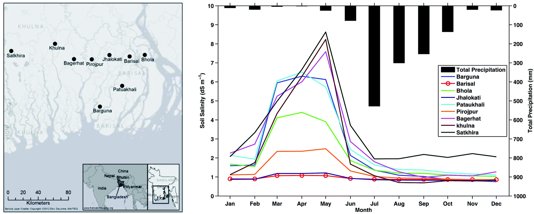 | ||
| Fig. 1 Seasonal variation of soil salinity and precipitation in southern Bangladesh (from Lazar et al. in this issue). Salinity data are district average values. | ||
This paper examines the potential impacts of salinization on coastal Bangladesh under plausible climate change scenarios. It is conducted within the context of the ESPA Deltas15 and the British Council INSPIRE scheme. The paper first examines salinity accumulation mechanisms and the scale of anticipated environmental change, including climate change. Then the study area and associated methods are outlined. The accumulation of salts by various methods are considered and results of an analysis of the impacts of using partly saline irrigation water in the dry season is presented. Key findings are then discussed and summarised.
Salinity accumulation mechanisms
Soil salinity in agricultural soils is determined via the electrical conductivity of a saturated paste of soil at 25 °C16 and it is usually expressed in deci-Siemens per m (dS m−1). Water salinity can be expressed in terms of its electrical conductivity (EC) or as dissolved salts parts salt per thousand (ppt).17 If irrigation water quality data is supplied as parts per thousand (ppt) they can be converted into electrical conductivity (dS m−1) using the formula ECw = (TDS/640) × 1000, where ECw is the electrical conductivity of the irrigation water (dS m−1), and TDS is the total dissolved solids (ppt).18,19 This relationship is semi-empirical and uses an assumed conductivity factor of 640; this depends on the salt species involved and can vary between 550 and 900. Whilst the relationship can be affected by temperature, standard methods assume a soil temperature of 25 °C16 – close to the average dry season air temperature in this region (26.5 °C).Soil salinity is a result of salt accumulation in the soil, which is affected by water salinity, drainage and evaporation. Crop production is generally unaffected in areas where the salinity of agricultural soils is below 4 dS m−1.20 Soil salinity in the dry season in Bangladesh results from a number of mechanisms including tidal inundation, irrigation using saline water, and the capillary rise of salts from shallow groundwater tables;13,14Table 1. Dry season inundation can be caused by tides and surges of brackish sea water (19–28 ppt; standard sea water is around 35 ppt). These can propagate from the Bay of Bengal up to 200 km into the delta in times of reduced river discharge.3,21
| Mechanism | Processes | Long term change factors |
|---|---|---|
| River water salinity | Tidal inundation (no defences) | Reduced river flows |
| Seepage through embankments | Upstream diversions | |
| Inundation (polders breached or poorly maintained) | Upstream dams | |
| Storm surges/cyclones | Overtopping of sea defences | Higher sea levels |
| Water ponding in low lying areas with silted up drains | Increased frequency of surges | |
| Depth to water table | Capillary rise (water table is <2 m from surface) | Increased pumping |
| Salinity of irrigation water | Irrigation with saline river or groundwater | Increased irrigation for leaching |
| Climatic variability | Irregular rainfall forcing more irrigation | Increased irrigation |
| Shrimp/fish cultivation | Deliberate introduction of saline water | Dependant on aquaculture |
| Lateral seepage to adjacent land | ||
| Contamination of shallow ground water |
Beltrán22 identifies capillary rise and applied irrigation as the two dominant mechanisms in salt accumulation in soils. Capillary rise causes salt accumulation from shallow groundwater which commonly occurs in irrigated areas in the dry Rabi season.23 This can result in a near continual supply of salt to the root zone as soil moisture is either absorbed by the crop or evaporated at the surface.24 Secondary salinization of agricultural land is the result of human activities such as irrigation, the use of coastal groundwater where sea water partly replaces fresh groundwater or direct evaporation from areas where the water table has risen due to poor drainage, over irrigation or sea level rise.
A developing problem in terms of salinity in Bangladesh is the adoption of brackish water shrimp cultivation. This is the third largest earner of foreign currency, with production primarily based in the southern regions around Khulna, Satkhira, Jessore and Bagerhat.25 The profits from shrimp culture exceed those of traditional agriculture and it is therefore unsurprising that shrimp culture is one of the most attractive land use practices.26 It provides a vital role in stimulating economic development within the coastal regions already affected by salinization. Unfortunately, a consequence of the shrimp culture involves the deterioration of coastal soils and ground/surface water sources through increased salinization.
Anticipated environmental change
The hydrographic and geographic setting for Bangladesh makes the country particularly vulnerable to saline intrusion and other effects of climate change. Effects include raised temperatures causing a higher irrigation demand, changes in rainfall patterns, increased climatic variability and/or shifts in the seasons. Saline intrusion into the delta and groundwater systems is likely to increase due to sea level rise and intensification of cyclones and storm surges. Other human induced factors such as the diversion of fresh water from the Ganges river in India will reduce the amount of fresh water entering the delta,3 whilst at the same time the maintenance of sea defences in Bangladesh is uncertain.Dasgupta et al.3 describe changes in river water salinity and provided projections of future river salinities for the year 2050. Results are given for a B1 greenhouse gas emissions scenario, which is relatively benign and a more aggressive or extreme A2 scenario. Fig. 2 shows anticipated changes in the distribution of slightly saline river waters (2 ppt) and more saline water likely to cause damage to crops (4 ppt). The present day isohalines indicate that the western sector is already affected by significant salinity, probably as a result of reduced fresh water river flows due to diversions at Farraka in India. The towns of Khulna and Satkhira and Bagerhat are already affected by salinities close to 4 ppt. Other regions currently affected are the southernmost regions of Barisal district and the eastern coastline along the west bank of the of the Padma (GBM) River.
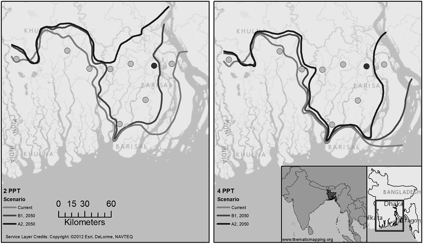 | ||
| Fig. 2 Isohalines of river water salinity in Bangladesh for current (2012) and future scenarios (2050 B1 and 2050 A2). Isohalines are interpolated between rivers. Based on data presented in Dasgupta et al., (2014). The dark circle indicates location of Barisal used for analysis in the following section. | ||
Lazar et al.27 show that climatic change alone is unlikely to reduce agricultural productivity in southern Bangladesh, but salinity is a significant problem that is difficult to assess due to the multiple interacting drivers. In this study, we assess problems associated with drought and salinity in dry season agricultural practice. The following sections will evaluate likely trajectories of salinity in the coastal region of Bangladesh up to the year 2098 by modelling scenarios of sea level rise, climate change and agricultural practices with varying water salt loads.
Study area, climate data and simulation model
The region around Barisal was selected as a study area because it lies in the transition zone of soil salinity problems. The dry season soil salinity in Barisal is relatively low (∼2 dS m−1) but nearby areas are becoming affected by increasing salinization e.g. Bhola (∼4 dS m−1) and Jhalokati (∼6 dS m−1); Fig. 1. Barisal has a long climatic record and is included in the FAO CLIMWAT 2 climatic database.28 A daily soil moisture deficit (SMD) model was constructed for the Barisal region between 1981 and 2098. SMD is defined as the amount of water in units of mm of rain (or irrigation) required to re-wet a dry soil so that the plant root zone is at field capacity (i.e. it can hold no more water). The model is based on the FAO CROPWAT single layer approach.29 It requires daily values of rainfall and potential evapotranspiration, crop characteristics (crop type, rooting depth and crop coefficient) and soil characteristics (soil type, structure and porosity).Daily precipitation values for 1981–2098 were provided by a 17 member ensemble of simulations of the HadRM3P (PRECIS) regional climate model developed by the Met Office Hadley Centre.30 The model is based on the HadCM3 global climate model and dynamically downscaled to assess regional climate variability.31 The model runs at a 0.22° × 0.22° resolution (∼25 km by 25 km), with 19 vertical levels and 4 soil levels.32 The ensemble member (labelled Q0) represents an unperturbed version of the model physics. The projections are driven by the Special Report on Emissions Scenario (SRES) A1B scenario,33 which lies between RCP6.0 and RCP8.5 in terms of atmospheric CO2 concentrations and global temperature projections.34 This represents a future for the coastal areas in Bangladesh which is approximately 4 °C warmer and 9% wetter by the year 2098. This paper reports results from the unperturbed model Q0. Two alternate scenarios were used to examine the sensitivity of the models developed, one which is warmer and drier (Q8) another which is warmer and wetter (Q16).30 The differences between the salinity accumulation due to the three climate scenarios is discussed at the end of the paper.
The inter-annual variability of the rainfall was calculated using the Standard Precipitation Index, a measure of the spread (in standard deviations) around the mean rainfall (Fig. 3). No clear change in variability is apparent in the 120 year sequence of rainfall and it appears that the current pattern of unpredictability of rainfall continues into the future.
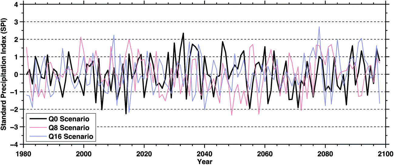 | ||
| Fig. 3 Variability in annual rainfall at Barisal 1981–2098. Data provided by Met Office PRECIS model based on a SRES A1B unperturbed scenario (Q0). | ||
Potential evapotranspiration (PE) was estimated using the FAO Penman Montieth approach with historical average climate data from the CLIMWAT 2 database.28 Daily values of PE were obtained by linear interpolation between monthly values. This approach was used in place of calculating daily PE values from HadRM3P generated climate data because the HadRM3P daily temperature and humidity sequences were generated independently and produced inconsistent sequences of PE. Inter-annual variability of PE is known to be small and only has a small impact on vegetation development,35 so the historical data were assumed to remain constant over a 20 year time period 1981–2000. Estimates of future potential evapotranspiration (PE) were generated by perturbing the historical climate data as suggested by Agrawala et al.,8 for the years 2014, 2030, 2050 and 2080 (Fig. 4). The main impact of climatic change is to raise the mean monthly evapotranspiration rate by approximately 0.15–0.2 mm per day by the 2080s. Annual PE rises approximately 6% from a baseline value of 1193 mm per year to 1263 mm per year.
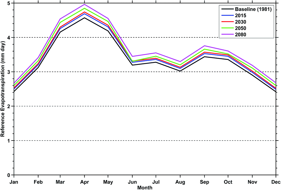 | ||
| Fig. 4 Monthly evapotranspiration (ET0) for Barisal. | ||
Soils in the Barisal region are silty clay loams. Typical crops grown in the dry season include potato, grass pea, chilli, tomato, cucumber, bean, aubergine, water gourd, and watermelon. These are simulated in the SMD model using a generic “small vegetable” rooting system 0.6 m deep at maturity. Crop and soil parameters used in the model are summarised in Table 2.
| Soil type | Medium (clay loam) |
|---|---|
| Total available soil moisture (TAM) | 290 mm m−1 |
| Maximum rain infiltration rate | 40 mm per day |
| Maximum rooting depth | 60 cm |
| Initial available soil moisture | 290 mm m−1 |
| Readily available soil moisture (RAM) | 145 mm m−1 |
| Crop coefficient (Kc) | 1.05 (mid-season) |
| Average depleted fraction of TAM (p) | 0.5 or 50% |
| Initial soil moisture depletion (as % of TAM) | 60% |
The SMD model was implemented in MATLAB and run on a daily basis over the 120 year period from 1981–2098. During the monsoon season, high rainfall results in near saturated conditions and the SMD is close to zero. In the dry season (approximately November–June), soils dry out and limited/unpredictable rainfall means that irrigation is necessary to grow some crops.
The SMD model was used to identify maximum soil moisture deficit without irrigation and the length of the dry season each year. This is calculated as the number of days the SMD is >145 mm i.e. when the readily available moisture in the soil profile has been used so crops will be under water stress and therefore their productivity will be reduced (Fig. 5). The maximum SMD is calculated assuming that there is no irrigation in the dry season. Maximum SMD values were found to be in the range 250–290 mm, but there was no increase in maximum SMD found during the 21st century. This is because despite potential evapotranspiration rising due to higher temperatures, the available water in the root zone is finite and this limits the total amount of evapotranspiration that can actually take place. However the higher temperatures mean the soil remains drier for a greater time and therefore the dry season becomes ∼20 days longer by the end of the 21st century. The shorter wet season and higher annual rainfall indicates that the wet season rainfall will be some 12–15% higher than at present.
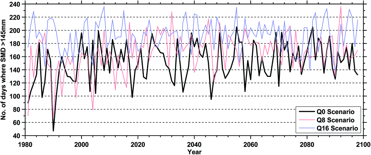 | ||
| Fig. 5 Calculated length of dry season in Barisal 1981–2098 (when unirrigated SMD >145 mm). | ||
The dry season irrigation water requirements for small vegetable crops were calculated using the SMD model. The calculation was based on optimal irrigation water delivery (i.e. the correct amount of water is delivered at the correct time to remove water stress), assuming an irrigation efficiency of 0.56 (Fig. 6). The efficiency is estimated as a product of an assumed in field water use efficiency of 0.7 and a conveyance efficiency of 0.8.36 The average irrigation water required is 4000 m3 ha−1 (or 400 mm depth in rainfall units). Inter-annual variability of rainfall results in ∼18% of years needing no irrigation – crops can be grown using soil moisture carried over from the monsoon period in exceptionally wet years. Conversely, in 10% of years significant dry season irrigation (>1200 mm) is needed.
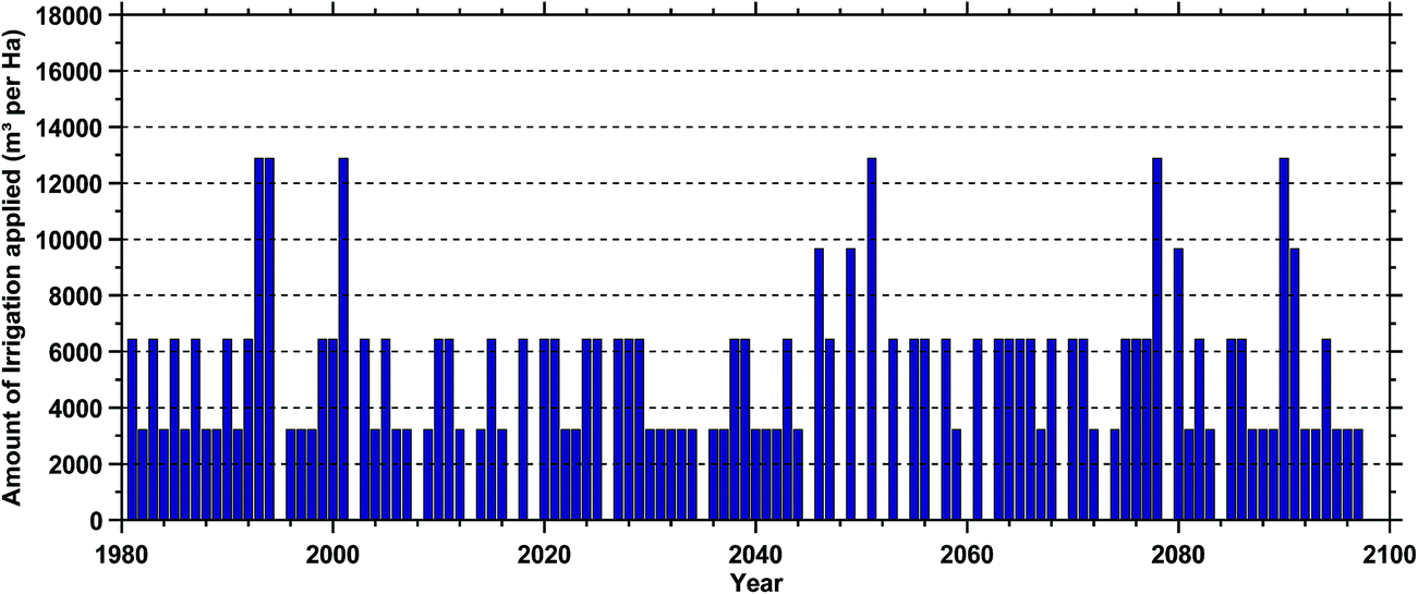 | ||
| Fig. 6 Irrigation water requirements for small vegetables in Barisal in the dry season 1981–2098. | ||
By the end of the 21st century, higher temperatures will increase potential evapotranspiration by ∼5% and annual rainfall is expected to increase by ∼9%. However the analysis suggests that there is no clear trend in the amount of water needed for dry season irrigation in the Barisal region. This agrees with the work of Lazar et al.27 who show that climatic change alone is unlikely to significantly affect agricultural production.
Accumulation of salts when irrigating with water of varying quality
To investigate the future trajectory of salt accumulation due to dry season irrigation, the mass of salt introduced to a farm was calculated using the volume of water needed to satisfy the irrigation water requirements. This calculation was performed each season with assumed irrigation water salinities of 3, 5 and 8 ppt, which covers a range from low to moderate salinity. The dry season salt mass accumulations were then compared to the leaching capacity of the next monsoon season, assuming that the drainage systems and other water control structures were operating adequately.The leaching requirement (LR) and the total depth of water needed to maintain a specified in field salt balance were calculated using the methods described in Ayers and Westcot.24 The average soil salinity tolerated by dry season vegetable crops grown (ECe) is used to define how much additional water at a salinity of ECw is required to leach the salts through the soil, known as the Leaching Requirement, LR:37,38 LR = ECw/(5 × ECe − ECw). The total depth of applied water (AW) needed to maintain a neutral salt balance is determined by: AW = ETc/(1 − LR) where AW is the depth of applied water (mm per year), to meet both crop evapotranspiration ETc (= PE × crop specific factor (FAO, no date)) and leaching requirements, LR.24
The values of LR used in this study were set at three thresholds with potential crop yield reductions of <10%, 25% and 50%, using typical values of ECe for vegetables in Ayers and Westcot.24 The calculated depth of partly saline irrigation water applied (AW) was then compared with the leaching capacity of the monsoon. In each year where the monsoon rainfall was greater than AW, it is assumed that salts are fully leached from the soil. However, where AW is greater than the monsoon, some salt remains in the soil profile and is carried over to the following dry season, adding to the salt loading in the next year.
Accumulation of unleached salts and expected crop yields
Fig. 7 shows the simulated differences between leaching requirements and the monsoon rainfall at Barisal between 1981 and 2098 under the Q0, Q8 and Q16 climate scenarios. Three irrigation water qualities were used in the analysis 3 ppt, 5 ppt and 8 ppt. Leaching requirements increase steadily over the 21st century due to a combination of higher crop evapotranspiration and the longer dry season. There is little difference due to the climate scenario used. Leaching requirements also increase with greater irrigation water salinity and some loss in crop yield is unavoidable, unless unrealistically large volumes of water are used in leaching. In this study we are limited by available rainfall in the monsoon season. At 3 ppt, little or no crop loss (<10%) is achievable in 96% of the time i.e. the monsoon is able to remove accumulated dry season salts in almost every year of the simulation (Fig. 8a). However at higher irrigation water salinities, salts accumulated during the dry season cannot be removed by the monsoon every year. With irrigation water salinity of 5 ppt, some salt is left behind in 40% of the years, resulting in an average decrease in crop yields of 25% (Fig. 8b). Irrigation with water at 8 ppt results in incomplete leaching in 65% of the years and an average crop loss of 50% (Fig. 8c). This level of damage is unlikely to be sustainable and farmers will not be able to grow a commercially viable crop in the dry season under these conditions.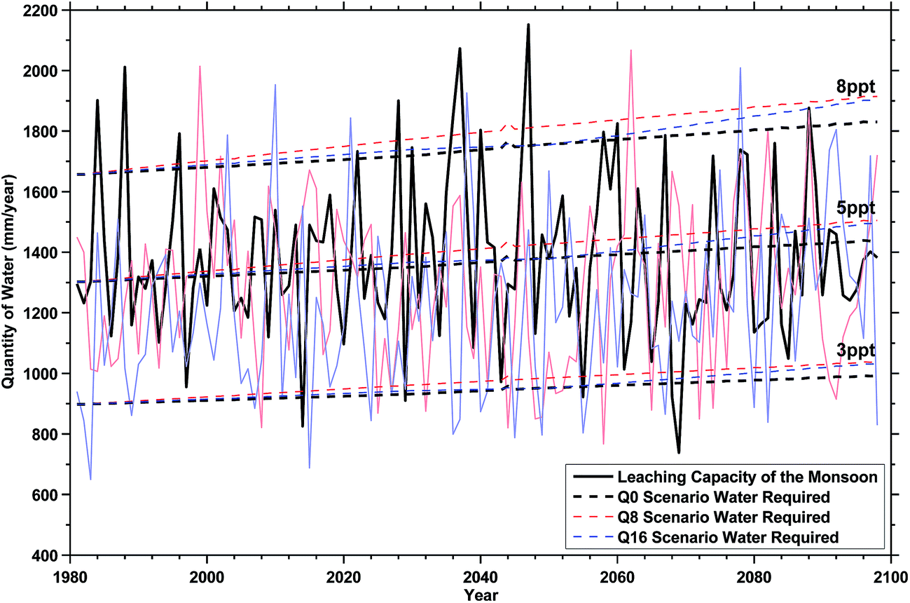 | ||
| Fig. 7 Crop water and leaching requirements for small vegetables irrigated with varying water salinities compared with the monsoon rainfall. | ||
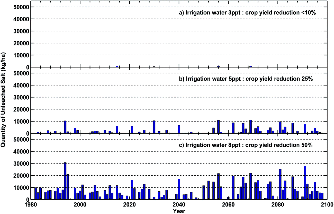 | ||
| Fig. 8 Unleached salts for irrigation water salinities of 3, 5 and 8 ppt. | ||
Some form of agricultural adaption will be necessary to cope with these conditions, however experience at present shows that marginal areas struggle at present to grow crops in the dry season. Work is currently underway to develop salt tolerant varieties of some crops and to encourage the adoption of crop types known to cope with these conditions (e.g. chilli, mustard, watermelon). However the low level of investment in infrastructure maintenance due to low incomes means that many drainage structures operate at below optimal capacity, exacerbating the accumulation of salts.
Discussion
Our results indicate that irrigating with water qualities >4 ppt will result in at least a 25% reduction in dry season crop yield. The irrigation water could be obtained from either surface or groundwater and the spatial distribution of groundwater salinity is described in Salehin et al.,39 but for the purposes of this discussion we will assume that only surface (river) waters are used. The future pattern of river salinities depends on the tidal amplitude, the extent of the landward penetration of the tides, and the volume of freshwater flow from upstream catchments. This trend is likely to shift landwards under future climate change with an increase in saline intrusion, subsequent increases in sea levels due to storm surges and subsidence of the delta, as well as reduced freshwater discharge by the GBM rivers during the dry season.3,40–42Dasgupta et al.3 modelled future river water salinities (Fig. 9, left). Using these projections to estimate the impacts on dry season crops, it is evident that irrigated agricultural productivity in the Barisal, Patuakhali, and Bhola districts is likely to fall ∼25% by 2050 due to salinity (Fig. 9, right). Some regions will experience dry season crop yield reductions of ≥50%. Regions further inland or closer to adequate supplies of fresh surface water (e.g. Pirojpur) experience little impact and as a result calculated potential crop yields are unaffected. Conversely, regions which are already experiencing severe salinity such as the southern coastal areas of Barisal and Khulna divisions are expected to see salinities >20 ppt by the end of the century, effectively curtailing dry season agriculture.
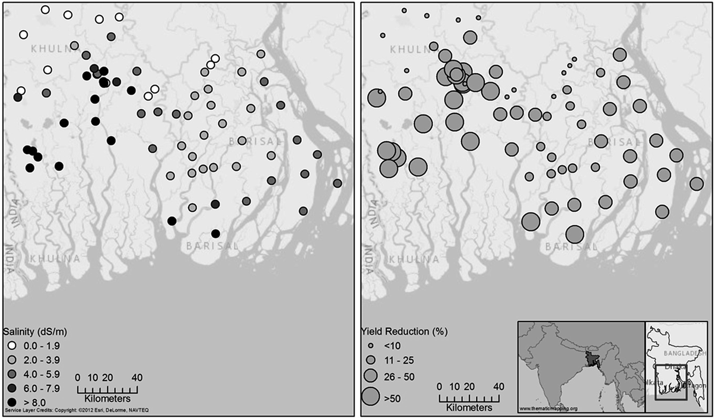 | ||
| Fig. 9 Left: projections of future 2050 river water salinities based on Dasgupta et al. (2014). Right: simulated crop yield reduction due to increased irrigation water salinity. | ||
Future agricultural practice will require farmers to adopt different land management approaches such as new crop varieties and alternate farming practices. Different seed bed shapes, correct seed placement and alternative furrow irrigation will help avoid reduced crop yield caused by salts accumulating in the root zone.24,43,44 Rain water harvesting methods may help mitigate the demands whilst allowing the application of good quality water from the monsoon.45–48 However, in areas where salinities are particularly high such as the Kalapara region, adaptation practices may not be enough to sustain acceptable agricultural production. A change in cultivation from agriculture to brackish water aquaculture could be an appropriate adaptation to future environmental conditions,26,48 although this will need to be sustainably managed to avoid contamination of adjacent farmland and drinking water supplies; problems that are already apparent.13,49
Summary
1. Salinity is a major factor affecting the environment in the coastal districts of Bangladesh. This was identified through our stakeholder workshops and famers meetings held in Sathkira, Khulna and southern Barisal districts in 2014. In these regions, dry season agriculture is already severely curtailed or impractical, and drinking water sources are also affected by salinity.2. The dry Boro season exhibits long-term climate forcing with the length of the season expected to increase by 20 days by the end of the 21st century. The length of the growing season (and hence critical crop planting dates) remains unpredictable. The monsoon Kharif II season is expected to decrease by 18 days. However the amount of monsoon rain will probably rise by 10–15%.
3. Over the region as a whole, inter-annual variability remains the dominant factor affecting dry season crop production and is more important than gradual climatic change in the 21st century. Dry Boro season irrigation requirements will remain unchanged throughout the 21st century, despite the influence of inter-annual variability causing changes to both the amount and timing of irrigation water requirements.
4. Salt accumulation in soils will increase if the sources of dry season irrigation water increases in salinity. The accumulation of salts on the agricultural land is a result of both the amount and quality of irrigation applied as well as the effectiveness of the monsoon rains to remove water by leaching/disposal through effective and well maintained drainage systems.
Conclusions
Agricultural production is the major ecosystem service in this region of Bangladesh. This work stresses the importance of salinity change as a potential limitation on agricultural production in coastal Bangladesh. Hence, it is vital to understand future salinity change. Lazar et al. (this issue) show that extrapolating salinity trends from historical data only suggests an overall increase in crop production due mainly to higher CO2 concentrations.The accumulation of salts on the agricultural land in the dry season is a result of both the amount and quality of irrigation applied and the effectiveness of the monsoon rains to remove water by leaching/disposal through good, well maintained drainage systems. However saline accumulation in soils will increase if the sources of dry season irrigation water increase in salinity. We demonstrate the immediate threat of crossing a tipping point of irrigation water quality (5 ppt) – which will cause long term accumulation of salts on agricultural land. Solutions to this problem will require a greater dissemination of the results of research on new crop types, varieties and farming practices.
Our findings reveal that both climate variability and saline intrusion are important drivers of determining both the climatic conditions and productivity of dry season agriculture by the end of 21st century. These effects will be particularly profound in some districts and greater emphasis should be placed on adopting agricultural practices suited to the future conditions. This however will require collaborative research at all levels, whilst also providing financial support to the local level farmers to aid the transition to new practices within the coastal zone.
Acknowledgements
Work for this paper was funded with support from the Ecosystem Services for Poverty Alleviation (ESPA) programme (project number NE-J002755-1) and the British Council ‘INSPIRE R-4’ exchange scheme. The ESPA programme is funded by the UK Department for International Development (DFID), the Economic and Social Research Council (ESRC) and the Natural Environment Research Council (NERC).Notes and references
- W. H. Yu, M. Alam, A. Hassan, A. S. Khan, A. C. Ruane, C. Rosenzweig, D. C. Major and J. Thurlow, Climate Change Risks and Food Security in Bangladesh, Routledge, London, 2010 Search PubMed.
- H. R. Rashid, Geography of Bangladesh, University Press Ltd, Dhaka, 1978 Search PubMed.
- S. Dasgupta, F. A. Kamal, Z. H. Khan, S. Choudhury and A. Nishat, River Salinity and Climate Change: Evidence for Coastal Bangladesh, Policy Working Paper Series 6817, The World Bank, Washington D.C., 2014 Search PubMed.
- M. F. Karim and N. Mimura, Impacts of Climate Change and Sea-level on Cyclonic Storm Surge Floods in Bangladesh, Glob. Environ. Change, 2008, 18, 490–500 CrossRef PubMed.
- Climate Change Cell (CCC), Climate Change Adaptation Research: Adaptive Crop Agriculture Including Innovative Farming Practices in the Coastal Zone of Bangladesh, Climate Change Cell, DoE, MoEF, Component 4b, CDMP, MoFDM, 2009.
- J. Thurlow, P. Dorosh and W. Yu, A Stochastic Simulation Approach to Estimating the Economic Impacts of Climate Change in Bangladesh, Rev. Dev. Econ., 2012, 16, 412–428 CrossRef PubMed.
- Z. Karim, S. G. Hussain and M. Ahmed, Salinity Problems and Crop Intensification in the Coastal Regions of Bangladesh, Bangladesh Agricultural Research Council (BARC) Soils Publication, 1990, vol. 33, pp. 1–63 Search PubMed.
- S. Agrawala, T. Ota, A. U. Ahmed, J. Smith and M. van Aalst, Development and Climate Change in Bangladesh: Focus on Coastal Flooding and the Sunderbans, Organisation for Economic Co-operation and Development (OECOD), Paris, 2003.
- M. K. Papademetriou and F. J. Dent, Crop Diversification in the Asia-Pacific Region, Food and Agriculture Organisation, Bangkok, 2001 Search PubMed.
- R. G. Allen, L. S. Pereira, D. Raes and M. Smith, Crop evapotranspiration – guidelines for computing crop water requirements – FAO Irrigation and drainage paper 56, Food and Agriculture Organisation, Rome, 1998 Search PubMed.
- M. S. Iftekhar and M. R. Islam, Managing Mangroves in Bangladesh: A Strategy Analysis, J. Coastal Conserv., 2004, 10, 139–146 CrossRef.
- S. A. Haque, Salinity Problems and Crop Production in Coastal Regions of Bangladesh, Pak. J. Bot., 2006, 38, 1359–1365 Search PubMed.
- M. Rashid and M. S. Islam, Bangladesh country paper for the 3rd session of the Technical Committee of Asian and Pacific Center for Agricultural Engineering and Machinery (APCAEM), Beijing, 2007.
- M. A. Haque, D. E. Jharna, M. N. Uddin and M. A. Saleque, Bangladesh J. Agric. Res., 2008, 33, 243–250 Search PubMed.
- R. J. Nicholls, J. Wolf, P. G. Whitehead, M. Rahman, M. Salehin and C. Hutton, A Synthesis of Environmental Change impacts on the ESPA DELTA region, Environ. Sci.: Processes Impacts, 2015 Search PubMed , submitted.
- J. Wolf, M. Barange, E. Barbour, L. Bricheno, J. Caeser, D. Clarke, S. Darby, J. Fernandes, T. Ghosh, A. Haque, S. Hazra, S. Islam, S. Kay, A. Lazar, S. Mondal, M. Rahman, M. Salehin, R. Torres and P. Whitehead, unpublished work.
- S. A. El-Swaify, in Plant Nutrient Management in Hawaii's Soils, Approaches for Tropical and Subtropical Agriculture, ed. J. A. Silva and R. Uchida, College of Tropical Agriculture and Human Resources, University of Hawaii at Manoa, 1998, pp. 151–158 Search PubMed.
- United States Soil Laboratory (USSL) Staff, Diagnosis and improvement of saline and alkali soils, Handbook 60, United States Department of Agriculture, Washington D.C., 1954, pp. 1–160 Search PubMed.
- R. R. Duncan, R. N. Carrow and M. Huck, Understanding Water Quality and Guidelines to Management, An overview of challenges for water usage on golf courses for the 21st century, USA Green Section Record, 2000, vol. 38, pp. 14–24 Search PubMed.
- M. A. Saleque, N. N. Choudhury, S. M. Rezaul Karim and G. M. Panaullah, Mineral Nutrition and Yield of Four Rice Genotypes in the Farmers' Fields of Salt-Affected Soils, J. Plant Nutr., 2008, 28, 865–875 CrossRef PubMed.
- M. K. Mondal, T. P. Tuong, S. P. Ritu, M. H. K. Choudhury, A. M. Chasi, P. K. Majumder, M. M. Islam and S. K. Adhikary, in Environment and Livelihoods in Tropical Coastal Zones: Managing Agriculture-Fishery-Aquaculture Conflicts, ed. C. T. Hoanh, T. P. Tuong, J. W. Gowing and B. Hardy, CAB International, Wallingford, 2006 Search PubMed.
- J. M. Beltrán, Irrigation with saline water: benefits and environmental impact, Agric. Water Manage., 1999, 40, 183–194 CrossRef.
- H. Brammer, Bangladesh's dynamic coastal regions and sea-level rise, Clim. Risk Manage., 2014, 1, 51–62 CrossRef PubMed.
- R. S. Ayers and D. W. Westcot, Water quality for agriculture, FAO Irrigation and Drainage Paper 29, Food and Agriculture Organisation, Rome, 1985 Search PubMed.
- A. Begum and S. M. N. Alam, in Primary aquatic animal health care in rural, small-scale, aquaculture development, ed. J. R. Arthur, M. J. Phillips, R. P. Subasinghe, M. B. Reantaso and I. H. MacRae, Food and Agriculture Organisation, 2002, vol. 406, pp. 191–200 Search PubMed.
- S. Hossain, S. M. N. Alam, C. K. Lin, H. Demaine, Y. Sharif, A. Khan, N. G. Das and M. A. Rouf, Integrated management approach for shrimp culture development in the coastal environment of Bangladesh, J. World Aquacult. Soc., 2004, 35–44 CAS.
- A. N. Lazar, D. Clarke, H. Adams, A. Razzaque Akanda, S. Szabo, R. J. Nicholls, Z. Matthews, D. Begum, M. A. Fazal, M. Saleh, M. A. Abedin, A. Payo Garcia, P. K. Streatfield, C. Hutton, M. S. Mondal and A. Z. M. Moslehuddin, Changing livelihoods of farmers under climate and environmental change in coastal Bangladesh - A modelling framework, Environ. Sci.: Processes Impacts, 2015 Search PubMed , submitted.
- CLIMWAT FAO, CLIMWAT 2.0 for CROPWAT, Version 2.0, Food and Agriculture Organisation, Rome, 2013 Search PubMed.
- D. Clarke, M. Smith and K. El-Askari, New software for crop water requirements and irrigation scheduling, Irrig. Drain. Pap., 1998, 47, 45–58 Search PubMed.
- J. Caesar, T. Janes, A. Lindsay and B. Bhaskaran, Temperature and precipitation projections over Bangladesh and the upstream Ganges, Brahmaputra and Meghna, Environ. Sci.: Processes Impacts, 2015 Search PubMed , submitted.
- United Nations Framework Convention on Climate Change (UNFCCC), Compendium on methods and tools to evaluate impacts of, and vulnerability and adaptation to, climate change, New York City, https://unfccc.int/adaptation/nairobi_work_programme/knowledge_resources_and_publications/items/5449.php, accessed 1st August 2014.
- N. Massey, R. Jones, F. E. L. Otto, T. Aina, J. M. Murphy, D. Hassell, Y. H. Yamazaki and M. R. Allen, Weather@home – development and validation of a very large ensemble modelling system for probabilistic event attribution, Q. J. R. Meteorol. Soc., 2014 DOI:10.1002/qj.2455.
- N. Nakicenovic, J. Alcamo, G. Davis, B. de Vries, J. Fenhann, S. Gaffin, K. Gregory, A. Grübler, T. Yong Jung, T. Kram, E. Lebre La Rovere, L. Michaelis, S. Mori, T. Morita, W. Pepper, H. Pitcher, L. Price, K. Riahi, A. Roehrl, H. H. Rogner, A. Sankovski, M. Schlesinger, P. Shukla, S. Smith, R. Swart, S. van Rooijen, N. Victor and Z. Dadi, Special Report on Emissions Scenarios: A Special Report of Working Group III of the Intergovernmental Panel on Climate Change, Cambridge University Press, Cambridge, 2000 Search PubMed.
- J. Rogelj, M. Meinshausen and R. Knutti, Global warming under old and new scenarios using IPCC climate sensitivity range estimates, Nat. Clim. Change, 2012, 2, 248–253 CrossRef.
- S. Fatichi and V. Y. Ivanov, Interannual variability of evapotranspiration and vegetation productivity, Water Resour. Res., 2014, 50, 3275–3294 CrossRef.
- C. Brouwer, K. Prins and M. Heibloem, Irrigation Water Management: Irrigation Scheduling, Training Manual No. 4, Food and Agriculture Organisation, Rome, 1989 Search PubMed.
- J. D. Rhoades, in Drainage for Agriculture, Am. Soc. Agron., ed. J. van Schilfgaarde, 1974, vol. 17, pp. 433–462 Search PubMed.
- J. D. Rhoades and S. D. Merrill, in Prognosis of Salinity and Alkalinity, Food and Agriculture Organisation Soils Bulletin 31, Rome, 1976, pp. 69–110 Search PubMed.
- M. Salehin, M. S. Mondal, D. Clarke, A. Lazar, M. M. A. Chowdhury and S. Norween, Deltas in Times of Climate Change II International Conference, Rotterdam, 2014 Search PubMed.
- N. Mohal, Z. H. Khan and N. Rahman, Proceedings of the 9th International River Symposium, Brisbane, 2006 Search PubMed.
- S. Dasgupta, M. Huq, Z. H. Khan, M. M. Z. Ahmed, N. Mukherjee, M. F. Khan and K. Pandey, Vulnerability of Bangladesh to Cyclones in a Changing Climate: Potential Damages and Adaptation Cost, Policy Working Paper Series 5280, The World Bank, Washington D.C., 2010 Search PubMed.
- M. Alam, in Sea-level Rise and Coastal Subsidence, ed. J.D. Milliman and B. U. Haq, Springer, New York, 1996 Search PubMed.
- L. Bernstein and M. Fireman, Laboratory studies on salt distribution in furrow irrigated soil with special reference to the pre-emergence period, Soil Sci., 1957, 83, 249–263 CrossRef PubMed.
- G. Fipps, Irrigation Water Quality Standards and Salinity Management Strategies, Agricultural Communications, Texas Cooperative Extension B-1667, 2003, pp. 1–20 Search PubMed.
- M. M. Rahman, M. Q. Hassan, M. S. Islam and S. Z. K. M. Shamsad, Environmental impact assessment on water quality deterioration caused by the decreased Ganges outflow and saline water intrusion in south-western Bangladesh, Environ. Geol., 2000, 40, 31–40 CrossRef CAS.
- M. Islam, M. R. Kabir and F. N. F. Chou, Feasibility study of rainwater harvesting techniques in Bangladesh, Rainwater and Urban Design Conference, Barton (A.C.T.): Engineers Australia, Sydney, 2007.
- M. S. Islam and M. Rashid, in Climate Change and Food Security in South Asia, ed. R. Lal, M. V. K. Sivakumar, A. H. M. M. Rahman and K. R. Islam, Springer, New York, 2011 Search PubMed.
- M. M. Rahman, V. R. Giedraitis, L. S. Lieberman, T. Akhtar and V. Taminskiene, Univers. Shrimp Cultivation with Water Salinity in Bangladesh: The Implications of an Ecological Model, J. Public Health, 2013, 1, 131–142 Search PubMed.
- M. A. Islam, M. A. Sattar and M. S. Alam, Impact of Shrimp Farming on Soil and Water Quality of Some Selected Areas in the Greater Khulna District, Research and Development Collective, Dhaka, Bangladesh, 1998 Search PubMed.
| This journal is © The Royal Society of Chemistry 2015 |