Recent trends in nutrient concentrations in Estonian rivers as a response to large-scale changes in land-use intensity and life-styles†
Arvo
Iital
*a,
Karin
Pachel
ac,
Enn
Loigu
a,
Margus
Pihlak
b and
Ülle
Leisk
a
aInstitute of Environmental Engineering, Tallinn University of Technology, Ehitajate tee 5, 19086, Tallinn, Estonia. E-mail: arvo.iital@ttu.ee
bInstitute of Mathematics, Tallinn University of Technology, Ehitajate tee 5, 19086, Tallinn, Estonia
cEstonian Environment Information Centre, Mustamäe tee 33, 10616, Tallinn, Estonia
First published on 16th November 2009
Abstract
The aim of the study was assessment of changes in nutrient concentrations in Estonian rivers as a response to improved wastewater treatment and substantial reductions in the use of fertilisers and number of livestock during the past 15–20 years. A Mann–Kendall test and flow adjusted technique to assess recent trends have been used. Statistical analysis covered time series of 53 sampling sites on 40 rivers and streams in different hydro-geographical regions and varying human pressures. The results indicate a statistically significant downward trend in nitrogen concentration in 18 sampling stations during the studied period; only very few showed an upward trend. These decreases in total nitrogen (TN) relate mainly to (i) substantial reductions in the use of fertilisers, (ii) decreased area of agricultural land, (iii) decreased point source load and (iv) increased self-purification capacity of soil-water systems. The concentration of phosphorus decreased only in 13 locations, despite of efforts to improve the efficiency of wastewater treatment. Moreover, in seven locations the concentration of phosphorus was increasing. This increase in total phosphorus (TP) probably relates to the low treatment efficiency of small wastewater treatment facilities as well as to the raised ground water table due to insufficient maintenance of drainage systems that favour transport of soil P to water bodies. Accordingly, the ratio of nitrogen and phosphorus had both decreasing and increasing trends.
 Arvo Iital | Arvo Iital is an assistant professor at the Department of Environmental Engineering, Tallinn University of Technology. He has an experience of 15 years in monitoring and assessment of surface water quality, assessment of environmental states, eutrophication of inland and coastal waters and environmental policy. Since 1994, he has been involved in many national and international projects in Europe and in Asia |
Environmental impact statementThere are many uncertainties and knowledge gaps in nutrient loss processes, making it difficult to determine direct cause–effect relations between the implemented environmental measures and surface water quality even under similar hydro-geographical conditions. This study assessed the impact of the transformed economic and social life and the implemented measures on nitrogen and phosphorus concentrations in all major rivers in Estonia over the past 15–20 years. The research results can be used for assessment of effectiveness of nutrient reduction measures defined by the watershed management plans and informing future policy decisions with regard to the threshold concentrations and use of suitable economic instruments. |
1. Introduction
High content of nutrients and eutrophication of inland and coastal waters is one of the main environmental concerns in the Baltic Sea Region.1 The ministers of the environment of the Member States of HELCOM adopted an ambitious action plan to drastically reduce the anthropogenic nutrient load to the Baltic Sea and restore a good ecological status by 2021. To achieve this, country-wise annual nutrient input reduction targets were proposed. During the past 15–20 years considerable changes in economy and social life took place in Estonia, expressed e.g. by an overall lower water consumption by people and industries, improved waste water treatment and lower intensity of agriculture. In many Eastern European countries, including Estonia, the highly industrialised and centralised agricultural production system collapsed in the late 1980s and early 1990s. Fertiliser use dropped six times in Estonia and constituted in 2005 only about 13% of the peak in 1987–1988.2 The decrease in livestock units (LU) was about twofold, the level today being 0.41 LU ha−1 of arable land; however, there are considerable variations among regions. The area of arable land (crop fields and cultural grasslands) decreased from about one million ha in the early 1990s to less than 0.6 million ha by 2003,2 being now about 0.6 million ha.3 About 34% of this arable land area was unused in 2001,4 mainly in less favourable areas.Despite of the lowered fertilisation rates, improved agricultural management practices and changes in landuse agriculture still remains the main source of diffuse pollution of inland surface waters, comprising 62% of TN and 43% of TP in 2004.5 In the last 5–6 years revitalisation of agriculture has been evident. Higher farmer income has led to an increase in N and P fertilisers use by 21 and 144 percent, respectively, compared to 1996.2 In addition, more agricultural land that had been abandoned is in use again. Financial support to maintain abandoned drainage systems has probably shortened nutrient retention time in some open water courses, but in many areas the maintenance of amelioration systems is still insufficient, thus favouring the retention potential, denitrification and biological uptake. All these changes provide a good opportunity to study the impact of the transformed economic and social life and the implemented environmental measures on surface water quality in Estonia, as well as their impact on reaching the goals of achieving high water quality standards set up by the EC Water Framework Directive (WFD).
It is widely accepted that nutrient concentrations in streams and rivers may respond differently to changes in agricultural production, rates of fertiliser application, and intensity of land use,6–16 and regional variability can be remarkable,17,18 especially with regard to the processes enhancing self-purification and retention capacity in the system: soil–groundwater–surface water. There are still many uncertainties and knowledge gaps in nutrient loss processes, making it difficult to draw direct cause-effect relationships between the implemented measures and water quality and answer the question why river systems respond differently even under similar hydro-geographical conditions. Stålnacke et al.19 pointed out that denitrification, presumably in smaller streams and channels, plays an important role in nitrogen reduction in the Baltic countries. Having mainly flat topography and a low density subsurface drainage system (distance between drains is usually 20 m), the longer water residence time in the catchments can play an important role.20,21 Moreover, poor maintenance of open drainage ditches also led to a rise in groundwater levels at field scale in Estonia in the 1990s,22 keeping the soils at saturated or near saturated conditions for longer time periods, leading to anaerobic conditions in soils with a possible increase in denitrification rates and subsequent lower nitrogen concentrations in open streams. These processes are probably enhanced by the high pH level (usually pH > 8), typical for surface waters in Estonia, that can also support direct ammonia volatilisation.
The paper describes the effects of large-scale changes in emissions on nutrient concentrations in Estonian rivers discharging to the Baltic Sea, its spatial and temporal variability and lag times to detect the response of a river system to changes in land-use and/or agricultural practices. This information can help environmental authorities and policy makers to focus on more cost-effective options to control pollution. Such knowledge can also be highly useful in the implementation and revision of river basin management plans within the EC WFD and in the selection of adequate measures and pricing policies to achieve a good ecological and chemical status of all water bodies by 2015.
2. Study area, data base and methods
2.1. Study area
The territory of Estonia is 45 227 km2, of which 43 200 km2 is land area (Fig. 1). The northern part of the country has a sedimentary cover consisting of Ordovician and Silurian limestones; the southern part is characterised by sandy-silty and clayey Devonian sandstone which is overlaid by quaternary deposits that are usually less than 5 m thick, and are the thickest (often > 100 m) in the uplands. Large limestone areas are characterised by the karst phenomenon where the thickness of quaternary deposits can be negligible. The topography is relatively flat, with maximum elevations usually about 30–100 m above sea level to 318 m in Haanja upland. Nearly 50% of the land is covered by coniferous and mixed types of forests, the rest being wetlands (22%) and agricultural land that forms about 23% of the land area. The main forest-forming species are pine (41%), birch (29%) and spruce (23%) and to a lesser extent alder.23 The area of wetlands includes mainly open fens and peat bogs but also inland and coastal marshes. The sown area of field crops is 560 × 1000 ha, of which about half is under cereals, nearly 40% used for production of forage crops and the rest is under potato, vegetables and industrial crops.2 The share of permanent grasslands and pastures is rather high, forming more than 7% of the total land area. | ||
| Fig. 1 Sampling sites. | ||
Mean air temperature in January is −6 to −7 °C in Eastern and Central Estonia and −2 to −4 °C in the Western part of the country. Average temperature in July is around 16.5–17 °C and mean annual precipitation is 600–650 mm.24 Spatial and temporal variation in mean snow cover duration is remarkable: 75–135 days a year. Long term mean precipitation varies from 550 to 880 mm exceeding substantially evaporation that is between 400–500 mm. Mean river runoff (260 mm) forms about 40% of annual precipitation.
2.2. Sampling strategy and analytical methods
State monitoring of river water quality involves 61 stations on 47 rivers and streams in Estonia. A statistical analysis was undertaken to discern trends in time series of total nitrogen (TN) and total phosphorus (TP) concentrations and TN:TP ratios for 53 sampling sites on 40 rivers and streams (Fig. 1, Table 1) where at least 13 years data set was available. A monthly time resolution was used for data from 27 of the sampling sites, and a biweekly or bimonthly resolution for the 24 sites. In two sites (Mustjõgi/Tulijärve and Oostriku/Oostriku) the sampling frequency is 4 times a year.| Site no. | River/sampling site | Catchment area/km2 | Population density/inhab km−2 | Land type | |||
|---|---|---|---|---|---|---|---|
| Forest (%) | Wetlands, other natural (%) | Agricultural (%) | Arable (%) | ||||
| 1 | Alajõgi/Alajõe | 140 | 2.7 | 65 | 19 | 15 | 2 |
| 2 | Ahja/Kiidjärve | 336 | 10.9 | 43 | 5 | 52 | 11 |
| 3 | Põltsamaa/Rutikvere | 861 | 15.8 | 43 | 13 | 41 | 24 |
| 4 | Rannapungerja/Roostoja | 313 | 5.0 | 58 | 18 | 21 | 8 |
| 5 | Emajõgi/Jõesuu | 3,374 | 16.2 | 40 | 8 | 42 | 16 |
| 6 | Võhandu/Räpina | 1,144 | 29.8 | 42 | 7 | 47 | 10 |
| 7 | Võhandu/Himmiste | 848 | 32.9 | 44 | 5 | 47 | 11 |
| 8 | Tänassilma/Oiu | 454 | 31.9 | 43 | 12 | 44 | 22 |
| 9 | Piusa/Korela | 733 | 9.5 | 46 | 8 | 45 | 8 |
| 10 | Avijõgi/Mulgi | 366 | 8.2 | 58 | 14 | 27 | 13 |
| 11 | Tagajõgi/Tudulinna | 252 | 2.8 | 62 | 29 | 8 | 1 |
| 12 | Kääpa/Kose | 282 | 5.1 | 58 | 13 | 28 | 15 |
| 13 | Tarvastu/Põdraoja | 108 | 16.4 | 39 | 4 | 56 | 28 |
| 14 | Pedja/Jõgeva | 665 | 7.5 | 50 | 13 | 36 | 22 |
| 15 | Pedja/Tõrve | 776 | 15.7 | 52 | 13 | 34 | 21 |
| 16 | Väike-Emajõgi/Pikasilla | 1,270 | 24.1 | 46 | 6 | 45 | 13 |
| 17 | Emajõgi/Tartu | 7,828 | 9.4 | 41 | 11 | 43 | 20 |
| 18 | Emajõgi/Kavastu | 8,539 | 21.9 | 42 | 11 | 42 | 19 |
| 19 | Narva/Vasknarva | 47,815 | 6.9 | 45 | 12 | 39 | 16 |
| 20 | Õhne/Suislepa | 577 | 14.3 | 47 | 12 | 38 | 16 |
| 21 | Õhne/Roobe | 266 | 5.4 | 53 | 18 | 27 | 13 |
| 22 | Porijõgi/Reola | 241 | 12.9 | 40 | 5 | 54 | 13 |
| 23 | Mustjõgi/Tulijärve | 16.2 | 4.3 | 59 | 16 | 25 | 6 |
| 24 | Preedi/Varangu | 34.8 | 8.4 | 35 | 8 | 56 | 34 |
| 25 | Oostriku/Oostriku | 29.7 | 12.1 | 23 | 4 | 70 | 53 |
| 26 | Narva/Narva | 56,060 | 7.2 | 45 | 14 | 37 | 15 |
| 27 | Vääna/suue | 316 | 57.7 | 35 | 10 | 44 | 25 |
| 28 | Pärnu/Tahkuse | 2,077 | 17.7 | 48 | 15 | 36 | 20 |
| 29 | Pärnu/Oore | 5,154 | 17.7 | 47 | 13 | 38 | 23 |
| 30 | Kasari/Kasari | 2,640 | 12.1 | 49 | 16 | 34 | 22 |
| 31 | Keila/Keila | 635 | 19.5 | 39 | 14 | 45 | 22 |
| 32 | Keila/mouth | 682 | 34.1 | 38 | 12 | 46 | 24 |
| 33 | Sauga/Nurme | 546 | 11.1 | 44 | 24 | 31 | 19 |
| 34 | Pirita/Lükati | 794 | 83.4 | 44 | 15 | 37 | 16 |
| 35 | Valgejõgi/Porkuni | 57 | 10.6 | 29 | 3 | 67 | 37 |
| 36 | Valgejõgi/mouth | 453 | 27.3 | 47 | 21 | 29 | 13 |
| 37 | Kunda/Lavi | 362 | 12.2 | 55 | 17 | 28 | 13 |
| 38 | Kunda/mouth | 528 | 15.5 | 49 | 13 | 37 | 17 |
| 39 | Navesti/Aesoo | 1,008 | 10.6 | 48 | 14 | 36 | 19 |
| 40 | Vihterpalu/Vihterpalu | 474 | 3.0 | 57 | 26 | 17 | 8 |
| 41 | Halliste/Riisa | 1,884 | 15.2 | 49 | 16 | 33 | 16 |
| 42 | Purtse/mouth | 810 | 60.4 | 48 | 23 | 24 | 13 |
| 43 | Velise/Valgu | 135 | 2.1 | 66 | 13 | 21 | 11 |
| 44 | Loobu/Vihasoo | 308 | 16.0 | 45 | 11 | 43 | 19 |
| 45 | Jägala/Linnamäe | 1,572 | 12.6 | 48 | 18 | 31 | 17 |
| 46 | Vodja/Vodja | 52 | 10.4 | 22 | 19 | 59 | 35 |
| 47 | Pühajõgi/mouth | 196 | 183.1 | 48 | 10 | 32 | 19 |
| 48 | Leivajõgi/Pajupea | 96 | 6.5 | 51 | 13 | 36 | 11 |
| 49 | Räpu/Arkma | 25.5 | 16.4 | 24 | 13 | 61 | 39 |
| 50 | Pudisoo/Pudisoo | 132 | 10.1 | 60 | 18 | 20 | 7 |
| 51 | Seljajõgi/mouth | 410 | 74.5 | 24 | 5 | 66 | 35 |
| 52 | Reiu/Lähkma | 548 | 12.2 | 62 | 17 | 19 | 9 |
| 53 | Saarjõgi/Kaansoo | 191 | 2.9 | 61 | 17 | 22 | 13 |
Analysis on the water samples was carried out using standardized methods (ISO 6878 for TP, ISO 11905 for TN and ISO 10304-1 for nitrate). The time series covered at least the period 1984–1987 to 2006 for 39 of the sites in the Lake Peipsi catchment, whereas 14 sites of the Baltic Sea catchment were investigated for 1992 (1991, 1994)–2006 (Table 2). Lake Peipsi drainage area is a sub-catchment of the basin of the Gulf of Finland and the Baltic Sea, and connected with the sea via the Narva River. The Lake Peipsi drainage basin makes up 36% of the Estonian territory and has an area of 47![[thin space (1/6-em)]](https://www.rsc.org/images/entities/char_2009.gif) 800 km2, including the surface of the lake itself, of which 16323 km2 is in Estonia and the rest in Russia and Latvia. Both small and large sub-catchments (ranging in size from 16.2 to 56060 km2) were studied (Table 1). All except two studied basins, the Narva River in the outlet from Lake Peipsi and in the river mouth, are smaller than 10000 km2. The catchment behind 40 sites is smaller than 1000 km2. The drainage areas of the Narva (sites No. 19 and 26) and Piusa (site No. 9) Rivers also include territory within the Russian Federation (69% and 34%, respectively).
800 km2, including the surface of the lake itself, of which 16323 km2 is in Estonia and the rest in Russia and Latvia. Both small and large sub-catchments (ranging in size from 16.2 to 56060 km2) were studied (Table 1). All except two studied basins, the Narva River in the outlet from Lake Peipsi and in the river mouth, are smaller than 10000 km2. The catchment behind 40 sites is smaller than 1000 km2. The drainage areas of the Narva (sites No. 19 and 26) and Piusa (site No. 9) Rivers also include territory within the Russian Federation (69% and 34%, respectively).
| Station number | Sampling site | Years monitored | Total N | Total P | ||
|---|---|---|---|---|---|---|
| MK-stat | P-valuea | MK-stat | P-valuea | |||
| a The trend is statistically significant if P-value is <0.05. P-value present a measure of the strength of the evidence, i.e. that the decision is incorrect. Bold type indicates results that are statistically significant at the 0.05 level (two-sided test). | ||||||
| 1 | Alajõgi-Alajõe | 1984–2006 | −2.74 | 0.006 | 2.74 | 0.006 |
| 2 | Ahja-Kiidjärve | 1985–2006 | −1.41 | 0.157 | −0.24 | 0.812 |
| 3 | Põltsamaa-Rutikvere | 1986–2006 | −2.80 | 0.005 | −1.30 | 0.194 |
| 4 | Rannapungerja-Roostoja | 1992–2006 | −2.69 | 0.007 | 2.04 | 0.042 |
| 5 | Emajõgi-Jõesuu | 1987–2006 | −0.05 | 0.960 | −1.23 | 0.219 |
| 6 | Võhandu-Räpina | 1986–2006 | −2.04 | 0.041 | −0.88 | 0.377 |
| 7 | Võhandu-Himmiste | 1991–2006 | −2.46 | 0.014 | −2.02 | 0.043 |
| 8 | Tänassilma-Oiu | 1986–2006 | 0.11 | 0.916 | −2.69 | 0.007 |
| 9 | Piusa-Korela | 1992–2006 | −2.72 | 0.007 | 0.35 | 0.727 |
| 10 | Avijõgi-Mulgi | 1992–2006 | −2.67 | 0.008 | 0.34 | 0.730 |
| 11 | Tagajõgi-Tudulinna | 1992–2006 | −3.18 | 0.001 | 0.82 | 0.413 |
| 12 | Kääpa-Kose | 1986–2006 | −0.66 | 0.506 | −0.69 | 0.489 |
| 13 | Tarvastu-Põdraoja | 1986–2006 | −3.11 | 0.002 | −2.73 | 0.006 |
| 14 | Pedja-Jõgeva | 1986–2006 | −0.90 | 0.370 | 1.32 | 0.188 |
| 15 | Pedja-Tõrve | 1986–2006 | −0.05 | 0.962 | 0.62 | 0.535 |
| 16 | Väike-Emajõgi-Pikasilla | 1986–2006 | −2.58 | 0.010 | −2.91 | 0.004 |
| 17 | Emajõgi-Tartu | 1984–2006 | 0.37 | 0.708 | 0.75 | 0.454 |
| 18 | Emajõgi-Kavastu | 1986–2006 | −0.55 | 0.583 | −1.42 | 0.155 |
| 19 | Narva-Vasknarva | 1992–2006 | −0.41 | 0.684 | 0.46 | 0.644 |
| 20 | Õhne-Suislepa | 1986–2006 | −2.34 | 0.019 | 1.49 | 0.137 |
| 21 | Õhne-Roobe | 1991–2006 | −2.44 | 0.015 | 1.85 | 0.064 |
| 22 | Porijõgi-Reola | 1992–2006 | −2.04 | 0.041 | −1.73 | 0.084 |
| 23 | Mustjõgi-Tulijärve | 1994–2006 | 2.34 | 0.019 | 2.54 | 0.011 |
| 24 | Preedi-Varangu | 1992–2006 | −2.44 | 0.015 | −2.39 | 0.017 |
| 25 | Oostriku-Oostriku | 1994–2006 | −0.77 | 0.443 | −3.50 | <0.001 |
| 26 | Narva-Narva | 1992–2006 | 1.68 | 0.093 | −0.59 | 0.555 |
| 27 | Vääna-mouth | 1992–2006 | −0.09 | 0.930 | 0.51 | 0.608 |
| 28 | Pärnu-Tahkuse | 1992–2006 | 1.74 | 0.082 | −2.29 | 0.022 |
| 29 | Pärnu-Oore | 1992–2006 | 0.93 | 0.353 | −0.76 | 0.450 |
| 30 | Kasari-Kasari | 1992–2006 | 1.21 | 0.226 | −1.78 | 0.074 |
| 31 | Keila-Keila | 1992–2006 | 1.38 | 0.167 | 2.44 | 0.015 |
| 32 | Keila-mouth | 1992–2006 | 0.35 | 0.726 | 0.35 | 0.730 |
| 33 | Sauga-Nurme | 1992–2006 | 2.09 | 0.037 | −1.58 | 0.114 |
| 34 | Pirita-Lükati | 1997–2004 | −0.24 | 0.806 | 0.15 | 0.883 |
| 35 | Valgejõgi-Porkuni | 1992–2006 | −1.41 | 0.159 | −1.84 | 0.066 |
| 36 | Valgejõgi-suue | 1992–2006 | −1.19 | 0.234 | −2.79 | 0.005 |
| 37 | Kunda-Lavi | 1992–2006 | −2.60 | 0.009 | −0.52 | 0.605 |
| 38 | Kunda-smouth | 1992–2006 | −2.43 | 0.015 | 1.64 | 0.101 |
| 39 | Navesti-Aesoo | 1992–2006 | 1.11 | 0.269 | −1.27 | 0.204 |
| 40 | Vihterpalu-Vihterpalu | 1992–2006 | 2.21 | 0.027 | 0.45 | 0.656 |
| 41 | Halliste-Riisa | 1992–2006 | 1.69 | 0.091 | −2.98 | 0.003 |
| 42 | Purtse-mouth | 1992–2006 | −2.39 | 0.017 | 2.04 | 0.042 |
| 43 | Velise-Valgu | 1993–2006 | 0.57 | 0.571 | 1.46 | 0.143 |
| 44 | Loobu-Vihasoo | 1992–2006 | −0.61 | 0.545 | −2.46 | 0.014 |
| 45 | Jägala-Linnamäe | 1992–2006 | −0.13 | 0.893 | 2.59 | 0.010 |
| 46 | Vodja-Vodja | 1992–2006 | 0.84 | 0.402 | −2.77 | 0.006 |
| 47 | Pühajõgi-smouth | 1992–2006 | −3.80 | <0.001 | −3.77 | <0.001 |
| 48 | Leivajõgi-Pajupea | 1992–2006 | 1.24 | 0.215 | 0.54 | 0.591 |
| 49 | Räpu-Arkma | 1994–2006 | 2.32 | 0.021 | 1.75 | 0.080 |
| 50 | Pudisoo-Pudisoo | 1992–2006 | 0.52 | 0.602 | 2.64 | 0.008 |
| 51 | Seljajõgi-mouth | 1992–2006 | −0.97 | 0.334 | −1.11 | 0.266 |
| 52 | Reiu-Rähkma | 1992–2006 | 1.25 | 0.210 | −2.06 | 0.040 |
| 53 | Saarjõgi-Kaansoo | 1992–2006 | 1.81 | 0.070 | −0.70 | 0.483 |
Agricultural data (use of fertilisers and manure) on the state and county level was obtained from the Statistical Office of Estonia. The land-cover data is based on the updated Corine Land Cover maps. Specific information about the actual land use and agricultural practices in studied catchments was not available. The annual data of wastewater quality and load as well as treatment efficiencies was provided by the Estonian Environment Information Centre.
2.3. Statistical methods
The statistical properties of water quality data (e.g. nutrient concentrations) are usually not normally distributed, and they often exhibit a hydrologic and seasonal pattern.25 Therefore a modified version of the seasonal Mann–Kendall test,26 referred to as the partial Mann–Kendall (PMK) test, which has been adapted to account for the influence of confounding variables, e.g. water discharge, was employed in our study. The PMK test also gives an opportunity for accounting missing data in data sets. The univariate Mann–Kendall statistic for a time series {Zk, k = 1,2,…,n} of data is defined aswhere
If there are no ties between the observations, and there is no trend in the time series, the test statistic is asymptotically normally distributed with

| E(T) = 0 and Var(T) = n(n − 1)(2n + 5)/18. |
is the Mann-Kendall statistic for season j, which is summed over all seasons to obtain the seasonal statistics

.

The Mann-Kendall statistic (MK-Stat) is the function of S, and this statistic has a standard normal distribution.
3. Results
The PMK test revealed statistically significant (P-value < 0.05; two-sided test) downward trend in TN at 18 of the 53 sampling stations (Table 2); the level of significance was very high (P-value < 0.01) at 10 of these 18 sites. A very rapid decrease in TN levels occurred as early as in the beginning of the 1990s at some of the locations (e.g. Võhandu-Räpina and Põltsamaa-Rutikvere; Fig. 2). Significant downward trend in TN was observed both in locations with a relatively higher share (>50%) of agricultural land in landcover (Preedi, Tarvastu, Porijõgi) as well as in catchments dominated by forests and wetlands (Tagajõgi, Avijõgi, Õhne - Roobe, Rannapungerja). In 4 sampling locations an upward trend of TN has been detected. These river basins vary considerably in size and represent both agriculture dominated catchments (Räpu) and catchments with very low population density and human pressure (e.g. Mustjõgi, Vihterpalu). | ||
| Fig. 2 Application of N and P fertilisers in Estonia in 1985–2007. | ||
For TP, the results of the PMK test were statistically significant for data from 20 sites (Table 2): 13 downward trends and 7 upward trends. Upward trends were observed both in very small catchments (Mustjõgi) and in larger catchments (Jägala, Purtse and Keila). Both for TN and TP the trends were significant in rivers with varying catchment size, but the maximum basin areas where trends were detected did not exceed 2,077 km2.
For TN:TP ratios a decline was noted at 11 and an increase at 10 of the 53 sites (Table 3).
| Sampling site No | MK-stat N/P | Sampling site No | MK-stat N/P | Sampling site No | MK-stat N/P |
|---|---|---|---|---|---|
| a The trend is statistically significant if P-value is <0.05. P-value present a measure of the strength of the evidence, i.e. that the decision is incorrect. Results given in bold type are statistically significant at the 0.05 level (two-sided test). | |||||
| 1 | −3.08 | 19 | −0.68 | 37 | −2.57 |
| 2 | −0.41 | 20 | −2.47 | 38 | −2.79 |
| 3 | −0.58 | 21 | −3.15 | 39 | 1.40 |
| 4 | −2.85 | 22 | −0.09 | 40 | 1.13 |
| 5 | 1.30 | 23 | −1.78 | 41 | 2.66 |
| 6 | −1.23 | 24 | 0.49 | 42 | −2.76 |
| 7 | −0.99 | 25 | 3.50 | 43 | −1.11 |
| 8 | 2.70 | 26 | 1.79 | 44 | 2.06 |
| 9 | −3.18 | 27 | −0.61 | 45 | −2.12 |
| 10 | −2.48 | 28 | 2.10 | 46 | 3.06 |
| 11 | −2.82 | 29 | 1.56 | 47 | 2.66 |
| 12 | −0.24 | 30 | 2.10 | 48 | 0.98 |
| 13 | 1.56 | 31 | −1.87 | 49 | 0.45 |
| 14 | −1.90 | 32 | −0.22 | 50 | −1.71 |
| 15 | −0.46 | 33 | 3.17 | 51 | 0.27 |
| 16 | 0.40 | 34 | 0.14 | 52 | 2.78 |
| 17 | −0.92 | 35 | −0.35 | 53 | 1.62 |
| 18 | 0.26 | 36 | 1.32 |
4. Discussion
Most of the studies in Europe have mainly dealt with the possible impact of increased emissions of nutrients on the water quality, and only a limited number of research results describe the response of water bodies to reductions in livestock density and point source load, changed agricultural practices and implemented mitigation measures. Moreover, this response has been mainly studied in smaller agriculture dominated watersheds. Even in these smaller catchments only weak correlation between the reductions in livestock density and concentrations of nitrogen and/or phosphorus in streams were detected by Ulén and Fölster13 and Kyllmar et al.15 in Sweden and Bechmann et al.27 in Norway. The lack of/weak trends was usually explained by a large interannual variation in losses that hide trends caused by changes in agricultural practice, and by the fact that the most effective mitigation methods were implemented before the monitoring period. For example, trend analysis carried out on time series starting in the 1980s showed significant downward trends in TP loss in Norway when the starting levels for P were high.16 Lack of or only weak responses in rivers, after rapid changes in land-use, decreased fertiliser application and improved wastewater handling in Eastern Europe, have been reported for N and/or P concentrations by Pekarova and Pekar28 in Slovakia, Olàh and Olàh29 in Hungary, Behrendt and Bachor30 in Germany, Stålnacke et al.12,31 in Eastern European rivers, Povilaitis14,32 and Sileika et al.33 in Lithuania and Kokorite et al.34 in Latvia. For P, there are usually only a few examples of statistically significant upward or downward trends detected e.g. by Povilaitis14 in Lithuania and Kokorite et al.34 in LatviaIn Estonia, studies about the impact on rivers of changes in land-use and fertiliser application have previously been performed mainly in smaller catchments. For small streams a downward trend in nitrate concentrations was detected by Loigu and Vassiljev35 in the rivers of the intensively cultivated Kurna catchment (23.2 km2, 68% arable land) during the period 1987–1996. The decrease was particularly conspicuous for peak concentrations, explained by the decreased application of fertilisers and agricultural intensity in the catchment. Mander et al.36 described downward nitrogen and phosphorus trends in another small (258 km2) agricultural catchment in Estonia. In his comprehensive study Iital et al.37 revealed 20 statistically significant downward trends in TN (one-sided test at the 5% level) from a total of 22 small and large sub-catchments of the entire Estonian part of the Lake Peipsi drainage area in 1981–2001. The trends were explained by: (i) a dramatic decrease in the use of organic and inorganic fertilisers (Fig. 2) and livestock numbers; (ii) increased proportions of grassland and abandoned land at the expense of cultivated and ploughed areas; (iii) better farm management practices. There was a significant downward trend for TP at only two sampling sites, and there was also an upward trend at two sites. The trends in TP were explained by changes in phosphorus emissions from the municipalities.
Our study results also indicate that the impacts of emissions of nutrients on water quality show wide variations; both strong trends for nutrient concentrations and lack of or weak responses in rivers can be reported. The findings of our study confirm that (i) a decrease in TN concentrations took place already in the early 1990s after which the pattern of amplitude and variability of TN concentrations has been rather stable (Fig. 3); (ii) there was also a decrease in TN concentrations at sites with catchments dominated by forests; (iii) there is a clear trend in TP concentrations in quite many rivers (Fig. 4). These interesting findings require a more detailed discussion.
 | ||
| Fig. 3 Time series of nitrogen concentrations in selected rivers in Estonia. | ||
 | ||
| Fig. 4 Time series of nitrogen concentrations in the Räpu River in 1994–2007. | ||
4.1. N concentrations
Plot experiments carried out in Estonia have shown that substantial amounts of nitrogen can be lost by leaching via the root zone, particularly after the harvesting of crops, resulting in nitrate concentrations as high as 60 mg N l−1 in soil-water.38 Our study results from the Kahametsa River in 1996–2003 show that very high TN levels occur in subsurface drainage water of agricultural catchment, where the 0.9 percentile of TN content varying between 12 to 18 mg N l−1 was much lower (7.2 mg N l−1) in the stream just a few hundred metres downstream the drains outlet. The mean TN content in Estonian rivers varies usually between 2–4 mg N l−1. These differences can at least partly be attributed to either plant uptake in the main channels or denitrification presumably in the ground water system and in smaller streams and channels.19It is likely that lowered consumption of organic and inorganic fertilisers has resulted in a remarkable decrease in the maximum concentrations of nitrogen in rivers,35 detected in the early 1990s in parallel to the fall in fertiliser use. The area fertilised by manure formed only 13% of arable land in 2005.2 Contrary, the consumption of inorganic fertilisers started to increase and fertilisers were applied to 80% of arable land in 2005. Nitrate of inorganic fertilisers is readily soluble and can be reduced through denitrification and volatilized under the high pH conditions of the surface water reducing nitrogen levels in the streams. The water residence times in Estonian river catchments are usually longer than in many other areas with similar geographical conditions,20 promoting these processes in water bodies. The main explanation for longer residence times besides the flat topography is poor maintenance of open drainage ditches that are often full of plants, including bushes of grey alder, enhancing thus biological uptake. According to the inventory39 68% of main drainage ditches needed maintenance in 2001, especially cleaning from trees, bushes and other plants.
All of the cited studies indicate that a soil–groundwater–stream system has a considerable potential for nitrogen retention. Only weak downward trends in dissolved inorganic nitrogen were reported for almost the same time period in Latvia by Stålnacke et al.12 It is possible that despite of the similar hydro-meteorological conditions and the decreased fertiliser use the studied rivers responded more slowly to the changes in nutrient loading due to their larger size.37 Recently Kokorite et al.34 detected a statistically significant decreasing trend of NO3–N in five out of 10 studied medium size rivers in Latvia in 1991–2001. In our study, the downward trends in TN in forested catchments (e.g. Tagajõgi, Avijõgi, Õhne –Roobe, Rannapungerja, Alajõgi), where forest area covers at least 55% of the catchment area, were primarily caused by the same factors that induced the downward trends in other catchments. Forests in Estonia very often require drainage. Insufficient maintenance of the main drainage ditches both in agricultural lands and forests during the past two decades, has resulted in overgrowth of bushes and macrophytes, which in turn enhanced the retention potential of ground water via raised water table level and by denitrification and biological uptake in the water systems.
The improvement of agricultural management practices in Estonia during the 1990s and increased crop uptake has led to a more efficient use of inorganic and organic fertilisers. The average unit area production of cereals has shown a significant increase during the past ten years and accounted 160 and 180% in the Järva and Lääne-Viru counties, respectively.2,40 These counties involve the most intensively used agricultural areas in Estonia. Higher plant uptake has probably had a positive effect on the field nitrogen balance, thereby reducing the nitrogen leaching to waterbodies.
The decline in the use of fertilisers, and large areas of unused crop lands and cultural grasslands, reaching its maximum in the late 1990s when about 34% of arable land was out of use, together with a remarkable share of wintergreen areas (up to 80% in some small agricultural catchments) also contributed to the decrease in nitrogen concentrations. Moreover, it is possible that particular hydro-geological conditions influence the rate at which nutrient concentrations in streams and rivers respond to changes in land use and nutrient emissions. The Estonian bedrock consists largely of Silurian and Ordovician limestone. Hence, there can be rapid exchange of water between upper and lower water tables through the existing cracks. Many rivers, especially in the Pandivere Upland, are fed by groundwater rich in nitrate-nitrogen. After the collapse of Soviet style agriculture, the nitrate content in groundwater aquifers decreased substantially.41 The response time to changed management practices in the groundwater system depends very much on the depth of the aquifer. The water quality of upper ground water layers (up to 10–15 m) improves quite rapidly after the elimination of local point sources. The exchange of water, especially in the upper aquifers, is rapid knowing that nearly 90% of precipitation which annually percolates into the ground, seeps into rivers and lakes or flows out of springs.42 The mean infiltration coefficients in the Silurian and Ordovician limestone are two to three times higher than in other parts of the country, being on the average 4–9 l s−1 km2, and the response time in water quality in deeper aquifers can also be relatively rapid (less than 10 years) if the exchange of water between upper and lower water tables takes place through the existing cracks.43 Several field studies have shown that at locations where oxygen is present at very low concentrations and where for example organic carbon is available, significant denitrification has been found. Gambrell et al.44 showed that losses of nitrate-nitrogen in undisturbed, poorly drained soils with relatively high water tables are lower compared to naturally well-drained soils, mainly as a result of denitrification. Moreover, Gilliam and Skaggs45 and Evans et al.46 revealed that water table management can reduce NO3–N in drainage water by over 60% partly due to an increase in denitrification, and that denitrification capacity which is affected by irrigation accounted for 15–30% of the decrease in NO3 concentrations in Nebraska's South Platte River aquifer studied by McMahon and Böhlke.47 It is possible that due to insufficiently maintained amelioration systems, groundwater level in Estonia rose in the 1990s and, thus, the soil maintains at saturated or almost saturated conditions for longer time periods leading to anaerobic environments in soils, a possible increase in denitrification rates and lower TN concentrations in open streams.
A statistically significant decreasing trend of TN concentrations in the Pühajõe River (site No. 47, Fig. 3) is probably very much related to substantially lowered point source load of wastewaters. The decrease of TN load from 307 tons in 1992 to 28 tons in 2007 can be explained by the fact that wastewaters from the largest settlement in the catchment, Jõhvi, have not been discharged to the river since 1999. The load of TN by wastewater formed nearly 100% of riverine nitrogen load in the early 1990s.
The threshold level of TN for good quality surface water set up by the decree of the Minister of Environment is 3 mg N l−1. All four locations where an upward trend of TN has been detected are already in a very bad (Räpu), bad (Mustjõgi) or only satisfactory (Vihterpalu and Sauga) quality class by nitrogen content in the water. Therefore it is difficult to presume that the requirements of the WFD quality criteria will be met by 2015 in these streams. It is very likely that the changed hydrological properties also played a major role in increasing TN concentrations in Estonia. For the period 1961–2003, in many rivers in the Baltic countries including Estonia, a significant increase in the winter season (December–February) runoff has been observed,48 reflected by higher minimum flows in winter.49 The snow cover period is shorter and more frequent freezing-thawing cycles during winter are common, leading to extremely high nitrogen concentrations in many water bodies in winter time (Fig. 4), a clearly decreasing trend of the share of spring (March–May) load of TN50 and high nutrient runoff levels.
4.2. P concentrations
A statistical trend analysis of TP clearly indicated that, in the majority of rivers, concentrations were fairly stable throughout the studied periods. However, it is surprising that in 20 out of 53 studied sites statistically significant (P-value < 0.05) decreasing or increasing trends were detected (Table 2, Fig. 5). This finding is somewhat different to our previous study results37 where only two downward and two upward trends out of 22 sampling sites were discovered in rivers of the eastern part of the country. It is very likely that different time frames for trend detection impacted the results and more conspicuous changes in concentrations occurred during recent years. For example in the Rannapungerja River (site No 4) the decreasing trend turned to a statistically significant increasing trend of TP.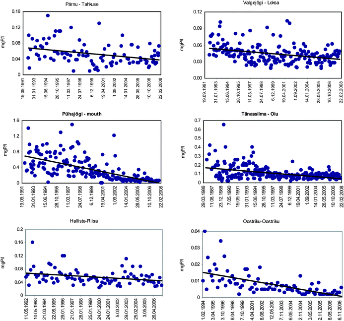 | ||
| Fig. 5 Time series of phosphorus concentrations in selected rivers in Estonia. | ||
The size of catchments of the streams where a marked increase in TP concentrations were detected, varies from 16.2 to 1570 km2 and only three of them (Keila-Keila, Purtse and Jägala) are relatively densely populated and/or have more arable land (14 to 22%) in the catchment. Thus, the reasons for increasing trends are probably quite different. In the Jägala (site No 45) River the lowered efficiency of wastewater treatment is probably contributing to the increasing TP concentrations in the recipient water body. Despite the improved performance of WWTPs the overall phosphorus load to the rivers is still fairly high. In larger municipalities the number of households and industries connected to the sewerage systems has grown, increasing the amount of nutrient-laden wastewater delivered to the treatment plants. This is probably the main reason for the increased TP content in the Keila (site No 31) and Purtse Rivers (site No 42). The upward trends in the Alajõgi (site No 1) and Rannapungerja (site No 4) can be explained by changes in land use, particularly by insufficient maintenance of amelioration systems that raised the groundwater level and enhanced transport of soil P to the drainage systems. This assumption is confirmed by increased sulfates concentrations in these rivers by almost two times during the studied period and an accompanied decrease in nitrate concentrations that might be explained by the occurrence and oxidation of pyrite in the aquifer, which is partly responsible for the reduction of nitrate and the production of sulfate.51 When studying P in the topsoil in Estonia, Haraldsen et al.52 have found that it is still at the same level as in the late 1980s, even though there had been a substantial decrease in the rate of application of P fertilisers. Soil has a high phosphorus absorption capacity but release of that element can occur after a time lag of several years.53 Six out of seven sites where TP showed an increasing trend are classified as only satisfactory (3 sites) or even bad (Jägala) and very bad (Pudisoo and Keila), i.e. the 0.9 pecentiles of TP concentrations in these streams exceed the threshold level (0.08 mg P l−1) for good quality surface water. The existing trends are not promising as regards meeting the requirements set by the WFD.
A clear downward trend in TP levels was observed in 13 rivers (Fig. 5). This can probably be explained by improvements in municipal wastewater treatment but also by a decrease in the number of inhabitants in rural areas, and, in particular, better handling of manure and fertilisers. A good example is the Väike-Emajõgi River (site No 16) where a decreasing trend appeared only after the renovation of the main point pollution source, the WWTP in Valga city in 2004. The load of phosphorus decreased from 1.3 tons in 2003 to 0.65 tons in 2005 and to 0.19 tons in 2007 after the implementation of the new phosphorus removal technology. Wastewater treatment efficiency, especially in larger settlements, improved a lot during the past 15 years, decreasing the point source load of both phosphorus and nitrogen (Fig. 6).
 | ||
| Fig. 6 Point source load of TN and TP to rivers in Estonia in 1992–2007. | ||
In some sub-catchments with relatively high point source emissions, evidence of decreased phosphorus concentrations was found; this was particularly noticeable during high-flow periods due to a dilution effect. For instance, in the Tänassilma (site No. 8) and Pühajõe Rivers (site No. 47), the observed downward trend in TP was most likely related to a decline in the amount of wastewater delivered to the WWTPs. The point load of phosphorus decreased from 20.2 tons in 1992 to 1.1 ton in 2007 in the Pühajõgi River and from 7.6 tons to 1.2 tons in the Tänassilma River. Therefore, considering the 0.9 percentile of TP concentrations, there was a decrease from 0.26 mg l−1 in 1986–1995 to 0.11 mg l−1 in 1996–2007 in the Tänassilma River. In the Pühajõgi River the concentrations fell from a relatively high level: 0.9 percentile of TP was 0.96 mg P l−1 in 1992–1994 and only 0.30 mg P l−1 in 2000–2006.
Only Võhandu, Tarvastu, Väike-Emajõgi, Preedi and Pühajõgi Rivers exhibited statistically significant downward trends in concentrations of both TN and TP. However, Pühajõgi was among the ten rivers in which an upward trend in the TN:TP mass ratio was detected (Table 3). These findings indicate that TP concentrations have decreased more than the corresponding TN concentrations. It is assumed that phosphorus compounds limit primary production and therefore also control the trophic level in surface waters.54 Consequently, a low N:P ratio may increase the probability of nitrogen limitation in surface waters.
In our study, a decline in the TN:TP ratios was noted at 11 and an increase at 10 of the 53 sites (Table 3). In four rivers (Alajõgi, Rannapungerja, Purtse and Jägala) a downward trend was accompanied by a significant increasing trend of TP. Eight rivers where the increasing trend of N:P ratios was detected exhibited a significant downward trend in TP concentrations. During the past two decades the decline in nitrogen loadings from diffuse sources and concentrations in the surface water bodies has been faster than the decreasing trend of phosphorus. This led to a situation where the N:P ratio dropped to very low levels, e.g. in the Piusa River where it has been less than 8 in 2004–2008. (Fig. 7). A further decrease in this level can enhance eutrophication processes in recipient water bodies, e.g. in Lake Peipsi, where intensive cyanobacteria blooms have been detected in the late 1990s and the 2000s.55 Therefore, more efforts should be made to reduce phosphorus load especially from smaller settlements.
 | ||
| Fig. 7 N:P mass ratio in the Piusa River in 1992–2007. | ||
5. Conclusions
• Statistically significant (two-sided test at the 5% level) downward or upward trends for TN and TP were detected only for relatively smaller rivers with catchment areas not exceeding 2000 km2.• A decreasing trend of TN has been characteristic both for rivers with a high share of agricultural land in catchments and in catchments dominated by forests and wetlands. The trends are more visible in rivers with longer data sets that include higher concentrations of the 1980s. Anyway it is obvious that several rivers have responded: (i) to the decrease in the area of agricultural land, (ii) decreased use of organic and inorganic fertilisers and livestock numbers; (iii) increased proportions of abandoned land at the expense of cultivated areas; (iv) better farm management practices.
• Decreasing and increasing trends in TP reveal that loading of phosphorus to surface water bodies from the municipalities varies a lot and its impact to the water quality requires more studies in the future. Treatment efficiency in larger cities is rather good, although varying temporally depending on the use of chemicals for phosphorus precipitation. Treatment is still insufficient in smaller settlements and even gets worse in some cases.
• Considering TN:TP ratios, both statistically significant upward and downward trends were observed. In some rivers a downward trend was accompanied by a significant increasing trend of TP. Eight rivers where the increasing trend of TN:TP ratios was detected exhibited a significant downward trend in TP concentrations and in six of these rivers the monitoring started only in 1992.
• It is very likely that diffuse nutrient losses from agriculture, including contribution by scattered dwellings, will be even more important in determining surface water quality in the future due to improvement of industrial and municipal wastewater treatment, especially regarding smaller settlements. Therefore different cost-efficient eco-engineering solutions are needed for considerable improvement of the retention capacity and removal of nutrients in the system soil–groundwater–surface water. These solutions primarily include prolongation of the water residence time in the system and enhancement of natural processes for denitrification and phosphorus sedimentation by using artificial wetlands and detention ponds, regulation of ground water level and other measures.
Acknowledgements
The study was performed under the research grants of Tallinn University of Technology B606A and Estonian Science Foundation 7656 and supported by EU funded project SCENES (Contract no. 036822).References
- B. M. Ulen and G. A. Weyhenmeyer, Environ. Sci. Policy, 2007, 10, 7–8 734–742.
- Statistical Office of Estonia, Agriculture Yearbook, 2006, 64 pp. Search PubMed.
- Statistical Office of Estonia, Agriculture in figures, 2007, 55 pp. Search PubMed.
- Statistical Office of Estonia, Agriculture Yearbook, 2003, 84 pp. Search PubMed.
- K. Oras, E. Grüner, K. Pachel and A. Iital, Statistical Office of Estonia, 2006, 50 pp..
- L. Kauppi, Publications of the Water Research Institute, National Board of Waters, Finland, 1979, 30, 21–41 Search PubMed.
- S. Rekolainen, Aqua Fennica, 1989, 199, 95–107 Search PubMed.
- D. R. Keeney and T. H. DeLuca, J. Environ. Qual., 1993, 22, 267–272 CAS.
- Z. Zablocki and P. Pienkovski, Nitrogen cycle and balance in Polish agriculture, 1999, 159–167 Search PubMed.
- G. Kutra, R. Aksomaitiene and A. Rackauskaite, Transactions of the Lithuanian University and Lithuanian Institute of Water Management, 2002, 18(40), 13–19 Search PubMed.
- L. Prochazkova, P. Blažka and J. Kopacek, Water Sci. Technol., 1996, 33, 145–152 CrossRef CAS.
- P. Stålnacke, A. Grimvall, C. Libseller, M. Laznik and I. Kokorite, J. Hydrol., 2003, 283, 184–205 CrossRef CAS.
- B. Ulén and J. Fölster, Sci. Total Environ., 2007, 373, 473–487 CrossRef CAS.
- A. Povilaitis, NHP Report 48, 2004, 1, 230–239 Search PubMed.
- K. Kyllmar, C. Carlson, A. Gustafson, B. Ulen and H. Johansson, Agric. Ecosyst. Environ., 2006, 115, 15–26 CrossRef CAS.
- M. Bechmann and P. Stålnacke, Sci. Total Environ., 2005, 344, 129–142 CrossRef CAS.
- N. Vagstad, H. E. Andersen, A. Iital, V. Jansons, K. Kyllmar, S. Rekolainen, R. Tumas and J. Deelstra, TemaNord, 2005, 583, 35–40 Search PubMed.
- J. Deelstra, K. Abramenko, N. Vagstad and V. Jansons, Proceedings of the 3rd International SWAT Conference, Zürich, 2005, 390–397 Search PubMed.
- P. Stålnacke, T. Tamminen, N. Vagstad, P. Wassmann, E. Loigu and V. Jansons, Hydrobiologia, 1999, 410, 103–110 CrossRef.
- J. Deelstra, N. Vagstad, E. Loigu, A. Vasiljev and V. Jansons, Proceedings of the 20th Nordic Hydrological Conference, 1998, 1, 120–129 Search PubMed.
- J. Deelstra, H. O. Eggestad, A. Iital and V. Jansons, Helsinki University of Technology Water Resources Publications, 2008, 16, 314–333 Search PubMed.
- N. Vagstad, V. Jansons, E. Loigu and J. Deelstra, Ecol. Eng., 2000, 14(4), 435–441 CrossRef.
- A. Raukas (Ed), Eesti Loodus. XII Metsad ja nende majandamine (in Estonian), 1995, 403–416 Search PubMed.
- J. Jaagus and A. Tarand, Eesti Geograafia Seltsi aastaraamat (in Estonian), 1988, 24, 5–18 Search PubMed.
- R. J. Gilliom and D. R. Helsel, Water Resour. Res., 1986, 22, 135–146 CrossRef.
- C. Libiseller and A. Grimvall, Environmetrics, 2002, 13, 71–84 CrossRef CAS.
- M. Bechmann, J. Deelstra, P. Stålnacke, H. O. Eggestad, L. Øygarden and A. Pengerud, Environ. Sci. Policy, 2008, 11, 102–114 CrossRef.
- P. Pekarova and J. Pekar, J. Hydrol., 1996, 180, 333–350 CrossRef CAS.
- J. Oláh and M. Oláh, Ambio, 1996, 25, 331–335.
- H. Behrendt and A. Bachor, Water Sci. Technol., 1998, 38(10), 147–155 CrossRef CAS.
- P. Stålnacke, S. M. Vandsemb, A. Vassiljev, A. Grimvall and G. Jolankai, Water Sci. Technol., 2004, 49, 30–36 Search PubMed.
- A. Povilaitis, Ekologija, 2006, 1, 32–39 Search PubMed.
- A. S. Sileika, P. Linacke, S. Kutra, K. Gaigalis and L. Berankiene, Environ. Monit. Assess., 2006, 122, 335–354 CrossRef CAS.
- I. Kokorite, M. Klavins and V. Rodionov, HJF Report, 2006, 2(5), 110–114 Search PubMed.
- E. Loigu and A. Vassiljev, Hydrology and Environment., 1997, 123–130 Search PubMed.
- Ü. Mander, A. Kull, V. Kuusemets and T. Tamm, Ecol. Eng., 2000, 14(4), 405–417 CrossRef.
- A. Iital, P. Stålnacke, J. Deelstra, E. Loigu and M. Pihlak, J. Hydrol., 2005, 304, 261–273 CrossRef CAS.
- T. Tamm, First Baltic Symposium on Environmental Chemistry, Abstracts, 2001, 93–94 Search PubMed.
- National Audit Office of Estonia, Audit Report No. OSIV-2–6/05/23, 2005 (in Estonian), 26 pp.
- Statistical Office of Estonia, Agriculture Yearbook, 1998, 140 pp. Search PubMed.
- I. Tamm, Report No. 3010 (in Estonian), 2003, AS Maves, Tallinn, 21 pp. Search PubMed.
- L. Vallner, Problemy gidrogeologii Estonii (in Russian), 1980, Tallinn, 11–120 Search PubMed.
- L. Vallner, Eesti. Loodus, Eesti Entsüklopeediakirjastus (in Estonian), 1995, 311–315 Search PubMed.
- R. P. Gambrell, J. W. Gilliam and S. B. Weed, Journal of Environmental Quality, 1975, 4, 317–323 CAS.
- J. W. Gilliam and R. W. Skaggs, J. Irrig. Drain. Eng., 1986, 112, 254–263 Search PubMed.
- R. O. Evans, J. E. Parsons, K. Stone and W. B. Wells, J. Soil Water Conserv., 1992, 47, 58–64 Search PubMed.
- P. B. McMahon and J. K. Böhlke, J. Hydrol., 1996, 186, 105–128 CrossRef CAS.
- A. Reihan, T. Koltsova, J. Kriauciuniene, D. Meilutyte-Barauskiene and A. Järvet, NHP report, 2006, 49, 601–608 Search PubMed.
- A. Reihan and E. Loigu, Environmental Impact and Water Management in a Catchment Area Perspective, Tallinn, Estonia, 2001, 135–140 Search PubMed.
- A. Iital, K. Pachel and J. Deelstra, Environ. Sci. Policy, 2008, 11, 185–193 CrossRef.
- A. Iital, J. Deelstra, P. Stalnacke, E. Loigu and M. Pihlak, NHP Report, 2004, 48(1), 169–179 Search PubMed.
- T. K. Haraldsen, E. Loigu, A. Iital, V. Jansons and N. Vagstad, Jordforsk report, 2001, 105/01, Norwegian Centre for Soil and Environmental Research, 22 p Search PubMed.
- N. Vagstad, P. Stålnacke, H. E. Andersen, J. Deelstra, A. Gustafson, A. Ital, V. Jansons, K. Kyllmar, E. Loigu, S. Rekolainen, R. Tumas and J. Vuorenmaa, TemaNord, 2001, 591, 74 pp. Search PubMed.
- A. Järvekülg, Water Pollution and Quality in Estonia, 1993, Environment Data Centre, National Board of Waters and the Environment, Helsinki, 29–34 Search PubMed.
- T. Nõges, R. Laugaste, E. Loigu, I. Nedogarko, B. Skakalski and P. Nõges, Water Science and Technology, 2005, 51(3–4), 267–274 Search PubMed.
Footnote |
| † Part of a themed issue dealing with water and water related issues. |
| This journal is © The Royal Society of Chemistry 2010 |