Development of water quality thresholds during dredging for the protection of benthic primary producer habitats†
Jeremy J.
Sofonia
a and
Richard K. F.
Unsworth
*b
aGHD, Pty Ltd, 239 Adelaide Terrace, Perth, 6000, Western Australia
bNorthern Fisheries Centre, Department of Employment Economic Development and Innovation, PO Box 5396, Cairns, QLD 4870, Australia. E-mail: richardunsworth@hotmail.com; jsofonia@gmail.com; Tel: +61 (0) 7 4057 3713
First published on 9th July 2009
Abstract
Given the potential for adverse effects of ocean dredging on marine organisms, particularly benthic primary producer communities, the management and monitoring of those activities which cause elevated turbidity and sediment loading is critical. In practice, however, this has proven challenging as the development of water quality threshold values, upon which management responses are based, are subject to a large number of physical and biological parameters that are spatially and temporally specific. As a consequence, monitoring programs to date have taken a wide range of different approaches, most focusing on measures of turbidity reported as nephelometric turbidity units (NTU). This paper presents a potential approach in the determination of water quality thresholds which utilises data gathered through the long-term deployment of in situ water instruments, but suggests a focus on photosynthetic active radiation (PAR) rather than NTU as it is more relevant biologically and inclusive of other site conditions. A simple mathematical approach to data interpretation is also presented which facilitates threshold value development, not individual values of concentrations over specific intervals, but as an equation which may be utilized in numerical modelling.
Environmental impactDredging and coastal development projects have long been identified as activities of high-risk for deleterious effects to the marine environment. It has been demonstrated, however, that effective environmental protection may be achieved through accurate impact assessment and the implementation of feedback monitoring and adaptive management strategies. The development of realistic, biologically meaningful, impact thresholds is therefore critical in both predictive impact analysis and rapidly distinguishing between anthropogenic change and natural variation. In this paper, we discuss a method for utilising background water quality data to assist in the prediction of environmental risk and the indicative assessment of changing conditions. The approach described has wide-spread potential in forecast modelling for coastal zone managers who depend on these predictions to inform their decision making processes. |
Introduction
Marine dredging and engineering projects, together with coastal land reclamation programs have been repeatedly cited throughout the primary literature as a source of significant ecological impact to local benthic primary producers (BPP) and their habitats.1–4 Elevated sedimentation regimes associated with such activities have been observed to cause stress, decrease growth, reduce cover, alter species composition, and/or inhibit recruitment in a number of marine and coastal ecosystems.4–7 The suspended sediment concentrations (SSC) that cause elevated turbidity may also impact BPPs by reducing the available light for photosynthesis, and alter both physical (e.g. hydrodynamic characteristics) and biological (e.g. growth, morphology) processes.4In an effort to assess the potential environmental risk and develop appropriate management measures of coastal and marine construction projects, the use of sophisticated mathematical models has become a key component in modern environmental impact assessment (EIA).8 These models are designed to incorporate specific information on the intended dredge program (e.g. cutting and disposal locations and rates), but also site-specific information such as bathymetry and geologic composition. Local hydrodynamics and prevailing meteorological conditions are also incorporated to estimate where the sediment plume may move through space and time. The capacity of these models to predict potential environmental impact, however, is not regulated only by the ability to predict where and when sediment plumes may be present, but site-specific knowledge of the location, composition and sensitivity of those ecological communities within this area. Hence, integral within the development of these models is the inclusion of suitable threshold limits. These define specific concentrations at which biological communities may be susceptible to adverse impact. Several studies have attempted to identify water quality thresholds of common coral species,9–12 however, the ability to effectively utilise such information within a dredge model in another location, particularly in mixed assemblages, may be limited due to differences in spatial, temporal, and environmental life histories between relevant biological taxa. It is therefore more appropriate to conduct site-specific, ‘baseline’, environmental assessments (e.g. water quality) wherein the natural range, duration, and frequency of change is measured and compared against the relative BPP health to determine threshold values.13,14 Unfortunately, methods to accurately quantify baseline water quality data and use it to calculate such thresholds, particularly in a manner pertinent for their use in plume modelling, remain poorly described.14
Recognised as an essential component in natural resource management, the federal, state and territory governments of Australia have worked jointly (since 1992) to develop and implement a National Water Quality Management Strategy (NWQMS). Included amongst the objectives of the NWQMS is the requisite for states and territories to establish, identify and adopt standard operating procedures for monitoring and analysis of data.15–17 Through this, there is a continued effort to develop approaches that distinguish between natural and anthropogenic change and can provide sub-lethal, early warning signs of emerging threats to the environment.
Marine dredge monitoring programs commonly place a strong emphasis on the measurement of turbidity concentrations for the development of water quality thresholds. This is on the basis that elevated turbidity will reduce levels of photosynthetically active radiation (PAR) available for energy production. As such, the threshold values estimated and set to trigger responsive management actions have been based on turbidity as measured by optical backscatter (OBS) point sensor devices which report in nephelometric turbidity units (NTU). While useful as a general indicator of SSC, the volume scattering functions of these materials are variable, and dependent upon factors such as particle size, composition and colour.18 The amount of light scattered into a given angle captured by the measuring device therefore also varies and may result in measured concentration error. SSC has been observed to account for 74–79% of the total variation in underwater irradiance.19 Thus, in monitoring programs where only SSC is assessed up to 26% of the change in BPP condition may be unaccounted for.
Indeed, how biologically relevant is the measure of SSC? We put forth for discussion, that BPPs are not so much affected by the volume of material in suspension, but rather the physical effect that these materials have on the subsequent light environment, principally the availability of PAR. Other than at light-saturating levels (e.g. within a working dredge plume), the significance of SSC on the underwater light climate is marginalised in that it is only one of several environmental parameters that influence available PAR and photosynthetic production. Light attenuation though the water column is not only dependent on the volume of SSC, but also material-specific characteristics and local hydrodynamic conditions that influence material suspension capacity.21 Seasonality and meteorology affect daily solar surface irradiances, sea surface conditions, tidal range, dissolved organic material as well as the transmission of this light through the air-sea interface all effect the ‘gross’ light available.
In this study, we investigate NTU and PAR data collected from waters several coral assemblages adjacent to an operational dredge program. We describe an approach to use site-specific background water quality data to calculate thresholds of potential dredge plume impact, and investigate why it may be more suitable to base these on the measurement of PAR rather than NTU. This method seeks to determine the relationships between the duration and intensity of water quality changes to develop site-specific water quality thresholds for use in numerical models and the prediction of potential impacts. In contrast to previous works, these thresholds are developed not as single values, but rather mathematical equations representing the minimum average light levels that healthy corals received over a series of increasing time periods. It is suggested that these equations may then be utilised as environmental trigger values for reactive dredge plume management.20
This is a site-specific analysis using data from an actual dredging project in Australia but placed within a hypothetical context for commercial reasons. This method applies new techniques to the principles of taking background environmental conditions as water quality thresholds.
Methods
Light climate at six sites was recorded (three offshore, three inshore), conducted using three repeat sampling locations at each site (total of 18 locations). At each location the light (PAR) was recorded every 30 min using an ALW-CMP quantum sensor and data logger (JFE ALEC CO., LTD, Kobe, Japan) positioned at a depth of approximately −6 m (LAT) and mounted vertically to star-pickets approximately 1 m above the corals. Automatic wipers mounted to each sensor prevented fouling and erroneous data collection. Additional collection of turbidity data was conducted at each site for comparison to PAR. This was conducted using a TROLL 9500 multi-parameter water quality logger (IN-SITU INC., Fort Collins Colorado, USA). Loggers were collected by divers for data acquisition every two weeks and replaced with serviced instruments (i.e. cleaned, calibrated and preventative maintenance). A detailed quality control procedure using logger serial numbers facilitated the management of the large data set as well as assisted in the identification and replacement of any instruments experiencing potential problems. Measurements of PAR and turbidity were sampled every 30 min for the duration of the 12-month sampling program. This data was then interrogated to determine the approximate minimum PAR received by corals over different durations ranging from 30 min to 8 wks at each site (Table 1).![[x with combining macron]](https://www.rsc.org/images/entities/i_char_0078_0304.gif) η) values calculated as rolling averages over increasing durations at one of the 18. Sampling interval (τ) = 30 min
η) values calculated as rolling averages over increasing durations at one of the 18. Sampling interval (τ) = 30 min
| Time (24 hr Clock) | PAR Measurement (Q) | 30 Minute Average (Γ = 30) | 1 Hour Average (Γ = 60) | 2 Hour Average (Γ = 120) | 3 Hour Average (Γ = 180) |
|---|---|---|---|---|---|
| 12:00 | 180.7 | ||||
| 12:30 | 181.3 | 181.0 | |||
| 13:00 | 174.2 | 177.7 | 178.7 | ||
| 13:30 | 197.1 | 185.7 | 184.2 | ||
| 14:00 | 214.1 | 205.6 | 195.1 | 189.5 | |
| 14:30 | 209.5 | 211.8 | 206.9 | 195.2 | |
| 15:00 | 186.9 | 198.2 | 203.5 | 196.4 | 192.0 |
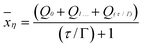
To calculate these values, the individual PAR measurements (Qn) at frequency of measure (τ) were averaged over the duration of interest (Γ):
 | (1) |
A rolling average was determined by simply dropping the first value, then adding the next value within the dataset. Within each duration period of interest, η were analysed to determine the minimum average light values (min) recorded. Thus, the min values utilised represent the minimum average light measured, at that site, over the given duration (Γ) observed over the 12-month period.
The min values were then plotted for each Γ at each monitoring location, and a relationship between intensity and duration was observed. Utilising the statistical software MiniTab (v13), a curve was fitted across these points producing an equation and an R2 value The effects of inter- and intra-site variability between these relationships were determined using Analysis of Co-Variance (ANCOVA). Where required, data was transformed using the log+1 function.
Note that instrument flooding and/or wiper failure occurred at several occasions over the sampling program resulting in either missing data (flooding) or data which were drifting due to fouling (wiper failure). Data were carefully reviewed prior to inclusion into the working data set and average values over each time period calculated using only complete sets of reliable data. For example, if a data gap occurred in calculating the 24 hr average, the next η value in the series would not be determined simply with the resumption of data, but rather only with the next set of 24 consecutive hours of data.
Results and discussion
The present study found that there was a significant relationship (p < 0.0001) between in situ measurements of NTU and PAR (Fig. 1), but that this quadratic relationship only explained 41% of the variance (R2 = 0.41). Further regression of these parameters at all the other sites (data not displayed) yielded similar R2 values. These results indicate that although NTU is a reasonable proxy of light, there exists a high level of unexplained variance within this relationship. The use of NTU as an environmental trigger to represent a risk of impact to benthic primary producers is therefore not always robust, in this case 59% error, and is consistent with previous water quality research that indicates strong linear relationships between turbidity and suspended sediment concentrations should not be expected.21 The present observations are also similar to those observed in Florida that found poor correlations between NTU and light transmission, particularly at lower turbidity levels (i.e. <11 NTU).22 The measurement of turbidity may therefore not always be appropriate to be used to determine light related environmental risk to benthic primary producers. This is particularly relevant to commercial development projects such as dredging, where reactive management requires making decisions such as shutting down a large dredge vessel in the event of an environmental risk. Such decisions that have enormous financial implications require decisions that are scientifically robust. | ||
| Fig. 1 Example of an observed relationship between in situ turbidity (NTU) and underwater light (PAR). | ||
Having determined NTU to be an unsuitable water quality indicator of a dredge plume, light availability (PAR) was used as the background water quality throughout the 12-month pre-dredge monitoring program every 30 min. Data were integrated at each location to determine the minimum average light over a series of durations (Fig. 2). The light environment was found to be significantly higher at offshore sites than at inshore sites (F1,125 = 121.77, p > 0.0001), such a higher light environment would be reflected in the composition of the local ecological communities of these sites.
 | ||
| Fig. 2 Minimum average light (±SE) plotted across the durations interrogated (T) for six monitoring sites. | ||
Overall, site (nested within distance from shore) was not found to be significantly affected by site; however when tested separately the offshore environment significantly differed between sites (F2,62 = 8.73, p < 0.0001). Offshore site B had a significantly lower light environment than offshore sites A and C. This use of ANCOVA enabled sites to be split into three statistically different light environments (1) Inshore A, B and C, (2) Offshore A and C; (3) Offshore B.
Within the three light environments, the lowest average value for each duration was taken as a minimum value observed to not negatively influence the benthic primary producers at that site (Fig. 2). This is on the basis that coral assemblages were monitored throughout the period of the collection of pre-dredge baseline water quality monitoring and were found to be unaffected by background water quality changes. These values were the minimum value observed at each of the three light environments and it was therefore assumed this would represent a point of risk. Light levels increased below these values represents unknown conditions and a level of increased risk of resulting in an impact to benthic primary producers. By fitting a line to this data we determined equations to represent the point of light availability vs. duration risk that can be utilised as conservative water quality thresholds. These equations are displayed in Fig. 3.
 | ||
| Fig. 3 Proposed water quality threshold relationships calculated for six monitoring sites based on determining the minimum average light level observed at each site. | ||
These equations could then be utilised within a dredge plume model allowing for both spatial and temporal predictions of possible threshold exceedances. Percentiles of the light dataset could also be calculated as ‘triggers’ for specific management measures (e.g. relocate dredge, reduce cutting rate).14 Examined relative to baseline habitat mapping as well as the proposed dredge program schedule, it could be possible to predict the the location and timing of potential impacts. Performed in advance, or ongoing during dredging, it may be possible to adjust the dredge program to avoid or limit ecological risk. The economic cost of these measures may be minimised if coordinated with scheduled maintenance such as bunkering, re-tooling.
Here we only separated data into sites, however, in the practical application of this method it may also be prudent to test for inter-season variability. This is because light regimes are likely to be highly reduced during periods of high rainfall, wind and waves. In the prediction and reactive management of a dredge plume it maybe useful to know when in a year periods of low light are likely to occur, as this will enable the intensity and location of dredging to be planned accordingly.
Given the protocol in calculating continuous average values, it becomes increasingly difficult to determine average values over longer periods of time as potential issues with instrumentation and loss of data also increases with time. This risk is minimised, however through the deployment of replicate instruments within each monitoring location.
We find that the use of turbidity as a water quality parameter is poorly related to underwater irradiance and hence only of limited use in examining potential risk to benthic primary producers during plumes of suspended sediments. We also illustrate how long term continuous baseline water quality data can be effectively utilised to develop water quality thresholds for an environmental risk assessment of a potential dredge project within an area of sensitive marine habitats. This method in threshold determination is considered conservative, as it is based on conditions that were observed to occur within the locality and caused no significant impact upon coral assemblages. Although many EIAs utilise laboratory and field values taken from the literature it is argued that these place levels of unacceptable inaccuracy and hence risk upon the local environment, potentially results in excess costs for the proponents, or even unnecessary ecological damage. By modelling site specific background data, decisions to make biologically significant water quality thresholds can be based on accurate information.
References
- R. E. Dodge and J. R. Vaisnys, Journal of Marine Research, 1977, 35, 715.
- D. S. Marszalek, Proceedings of the Forth International Coral Reef Symposium, Manila, 1981, 1, 147 Search PubMed.
- B. E. Brown, M. D. A. Le Tisser, T. P. Scoffin and A. W. Tudhope, Marine Ecology Progress Series, 1990, 65, 273 CrossRef.
- C. S. Rogers, Marine Ecology Progress Series, 1990, 62, 185 CrossRef.
- J. N. Cortès and M. J. Risk, Bulletin of Marine Science, 1985, 36, 339 Search PubMed.
- R. H. Richmond, American Zoology, 1993, 33, 524 Search PubMed.
- B. E. Brown, in Life and death of coral reefs, ed. C. Birkeland, Chapman and Hall Inc, New York 1997, pp. 354 Search PubMed.
- R. Koskela, P. Ringeltaube, A. Small, T. Koskela, A. Fraser, J. Lee and P. Marshall, Recent Advances in Marine Science and Technology, 2003, 94, 183 Search PubMed.
- C. S. Rogers, Maine Pollution Bulletin, 1983, 14, 378 Search PubMed.
- R. Babcock and P. Davies, Coral Reefs, 1991, 9, 205 CrossRef.
- M. G. Stafford-Smith, Marine Biology, 1993, 115, 229 CrossRef.
- J. J. Sofonia and K. R. N. Anthony, Estuarine and Costal Shelf Science, 2008, 78, 748 Search PubMed.
- C. P. Newcombe, in Habitat Protection Branch, Ministry of Environment, Lands and Parks.Victorida, BC, Canada 1994 Search PubMed.
- C. McArthur, R. Ferry and J. Proni, Dredging 02-Proceedings of the Third Specialty Conference on Dredging and Dredged Material Disposal. Orlando, Florida, USA, 2002 Search PubMed.
- DEWHA, in Australian and New Zealand Environment and Conservation Council and Agriculture and Resource Management Council of Australia and New Zealand. Available from the Australian Department of the Environment, Water, Heritage and the Arts site, http://www.environment.gov.au/water/publications/quality/index.html 1994 Search PubMed.
- DEWHA, in Australian and New Zealand Environment and Conservation Council and Agriculture and Resource Management Council of Australia and New Zealand. Available from the Australian Department of the Environment, Water, Heritage and the Arts website, http://www.environment.gov.au/water/publications/quality/index.html, 2000 Search PubMed.
- DEWHA, in Australian and New Zealand Environment and Conservation Council and Agriculture and Resource Management Council of Australia and New Zealand. Available from the Australian Department of the Environment, Water, Heritage and the Arts website, http://www.environment.gov.au/water/publications/quality/index.html 2000 Search PubMed.
- A. Hatcher, P. Hill, J. Grant and P. Macpherson, Marine Geology, 2000, 168, 115 CrossRef CAS.
- K. R. N. Anthony, P. V. Ridd, A. Orpin, P. Larcombe and J. M. Lough, Limnology and Oceanography, 2004, 49, 2201.
- J. R. Turner, R. Boak, R. Klaus, D. Daby and E. Hardman, in Coral Reef Conservation, eds. I. Cote and J. Reynolds, Cambridge University Press, 2006, pp. 643 Search PubMed.
- C. Gippel, Hydrobiologia, 1989, 176/177, 465 CrossRef.
- G. J. Telesnicki and W. M. Goldberg, Bulletin of Marine Science, 1995, 57, 540 Search PubMed.
Footnote |
| † Part of a themed issue dealing with water and water related issues. |
| This journal is © The Royal Society of Chemistry 2010 |