
High-resolution maps of carbon dioxide and moisture fluxes over an urban neighborhood†

Abstract
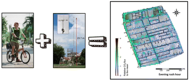
Based on the Monin–Obukhov similarity theory and challenging the Reynolds analogy, the aerodynamic resistance approach to estimate the transfer of sensible heat (QH) can be used as a proxy to investigate the surface–atmosphere exchange of any passive scalar, such as carbon dioxide (CO2) and moisture (H2O). As a proof of concept, a bicycle was instrumented to measure georeferenced mixing ratios of CO2 and H2O every second along a defined route across a residential neighborhood of Singapore during ∼1.5 hours periods. These measurements are used in conjunction with readings of incoming and outgoing longwave radiation, and fluxes of QH collected from a tall eddy covariance flux tower located within the study area, to derive exchange rates of CO2 and H2O along the transect route considering the bulk aerodynamic resistance to QH as equivalent to the bulk aerodynamic resistance for both trace gases. An interpolation subroutine based on the original Delaunay triangulation is then applied to interpolate the observed fluxes across the neighborhood for 20 × 20 m grid cells. This approach is able to identify hotspots of CO2 emissions, and spots of evapotranspiration or anthropogenic moisture directly associated with the energy channeled into latent heat. No other method based on field observations can deliver information on the exchange of CO2 and H2O with such fine spatial resolution. For the particular neighborhood assessed in this study, larger emission rates of CO2 are observed at traffic intersections along major roads, as well as at an urban block with multiple eateries and coffee shops. With respect to fluxes of H2O, high evapotranspiration rates are observed along a drainage channel at one end of the neighborhood and along blocks with narrow and densely tree-lined streets. The sum of the interpolated fluxes from all grid cells for each individual set of measurements agrees within one standard deviation with the long-term fluxes of CO2 and H2O measured by eddy covariance over the entire neighborhood.
 Please wait while we load your content...

