Proximity analysis of air pollution exposure and its potential risk
Abstract
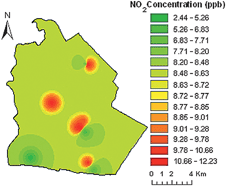
Proximity analysis and spatial variability of the ambient nitrogen dioxide (NO2) concentration in Rayong province, Thailand, were analyzed using geostatistics and spatial modeling techniques. Annual concentrations of nitrogen dioxide were predicted and spatially interpolated using various interpolation techniques (i.e. kriging, IDW and spline). Sensitivity analysis was carried out to assure the accuracy of the predicted results. The GIS-based exposure map was simulated and was assisted to identify high exposure areas. A health risk warning system was set for “action” (exceeds 100% of the annual average NO2 guideline), for “alert” (between 66–100% of the annual average NO2 guideline) and for “some concern” (between 33–66% of the annual average NO2 guideline). Although no areas were exposed to an action level, many locations in the study area could have levels of “some concern”. Potential risk to the population was analyzed by spatial interpolation of the nitrogen dioxide concentration with population data. The result indicated the number of people exposed to air pollution, as well as the areas which have a high risk to air pollution. About 88.3% of the total population in the study area live in areas where levels of air pollution are designated as being in the “some concern” zone. About 6.7% of the registered population have their residence in an area where action should be taken for air quality management. The study demonstrates the application of GIS-based prediction for the evaluation of exposure mapping, in order to determine the spatial extent and frequency of areas where pollution levels exceed target values, and their potential health impacts.


 Please wait while we load your content...