
 Open Access Article
 This Open Access Article is licensed under a Creative Commons Attribution-Non Commercial 3.0 Unported Licence
Temporal variability and regional influences of PM2.5 in the West African cities of Abidjan (Côte d'Ivoire) and Accra (Ghana)†
Julien
Bahino
 *abc,
Michael
Giordano
agh,
Matthias
Beekmann
ch,
Véronique
Yoboué
b,
Arsène
Ochou
b,
Corinne
Galy-Lacaux
d,
Cathy
Liousse
d,
Allison
Hughes
f,
James
Nimo
f,
Farouk
Lemmouchi
a,
Juan
Cuesta
a,
A. Kofi
Amegah
e and
R.
Subramanian‡
ch
*abc,
Michael
Giordano
agh,
Matthias
Beekmann
ch,
Véronique
Yoboué
b,
Arsène
Ochou
b,
Corinne
Galy-Lacaux
d,
Cathy
Liousse
d,
Allison
Hughes
f,
James
Nimo
f,
Farouk
Lemmouchi
a,
Juan
Cuesta
a,
A. Kofi
Amegah
e and
R.
Subramanian‡
ch
aUniversité Paris Cité and Univ Paris Est Creteil, CNRS, LISA, F-75013, Créteil, France. E-mail: julienbahino@gmail.com
bLaboratoire des Sciences de la Matière de l'Environnement et de l'Energie Solaire (LASMES), UFR SSMT, Université Félix Houphouët-Boigny d'Abidjan, Abidjan, Côte d'Ivoire
cOSU-Efluve, Univ Paris Est Creteil and Université Paris Cité, Ecole des Ponts Paris Tech, CNRS, F-94010 Créteil, France
dUniversité Toulouse III - Paul Sabatier, CNRS UMR 5560, IRD UMR-S994, Toulouse, France
ePublic Health Research Group, Department of Biomedical Sciences, University of Cape Coast, Cape Coast, Ghana
fDepartment of Physics, University of Ghana, Accra, Ghana
gKigali Collaborative Research Centre, Kigali, Rwanda
hUniv Paris Est Creteil and Université Paris Cité, CNRS, LISA, F-94010, Creteil, France
First published on 19th March 2024
Abstract
Particulate Matter (PM) Low-Cost Sensors (LCS) can be used to monitor air quality in regions with limited access to reference monitors. This study carried out within the framework of the Improving Air Quality in West Africa (IAQWA) project provides high temporal resolution of data on fine aerosol (PM2.5) mass concentrations in Abidjan (Cote d'Ivoire) and Accra (Ghana) through the deployment of field calibrated Real-time Affordable Multi-pollutant (RAMP) monitors. From February 2020 to June 2021, RAMPs were deployed at five sites in Abidjan and four sites in Accra. Using a temporal resolution of 15 seconds, the datasets provided by RAMPs allowed a comparative analysis of diurnal, daily and seasonal variability of PM2.5 concentrations for different urban sites with distinct pollution sources, over an extended period of time. Diurnal variations in PM2.5 concentrations showed prominent morning peaks related to traffic rush hours reaching up to 50 μg m−3. Evening peaks were significant for sites in residential neighborhoods, and pointed to residential type pollution sources. Seasonal differences are analysed over a yearly cycle and maximum values are found during the so-called long dry season (Harmattan), between December and February. During a prominent pollution episode in January 2021 observed by the ground network, analysis of 3D satellite data, revealed Saharan dust transport as an additional source of (fine) aerosol pollution significantly increasing PM2.5. The same episode also revealed a limitation of LCS – an inability to adequately capture dust-dominated pollution, which can be quantified by reference monitors. Annual average PM2.5 concentrations vary between 17 and 26 μg m−3. PM2.5 differences between sites within a city, especially between traffic impacted and urban background sites, are larger than the differences between the two cities. These annual averages exceed World Health Organization (WHO) annual pollution thresholds from the 2005 (10 μg m−3) and 2021 (5 μg m−3) guidelines.
Environmental significanceThis research paper makes a significant contribution to atmospheric science and the understanding of air quality in West Africa. It addresses the lack of air monitoring networks in West Africa by conducting a long-term survey of PM2.5 concentrations in Abidjan and Accra. By co-locating lower-cost monitors with reference monitors, data quality is improved, enabling comprehensive analysis. The study reveals diurnal and daily variations in PM2.5 levels, and compares them with WHO AQG. It also highlights the seasonal variability and regional impact of Saharan dust during the Harmattan season. The research underlines the potential of low-cost sensors to fill the air quality data gap in developing countries, while highlighting the need for a comprehensive monitoring approach for better air quality management. |
1 Introduction
West Africa has experienced strong economic growth since the early 1990s. According to the African Development Bank (AfDB), real Gross Domestic Product (GDP) growth in West Africa has slowed from 4.4% in 2021 to 3.6% in 2022. It should recover in the medium term, reaching 4.1% in 2023, despite the extremely difficult international economic context.1 The largest economies in the West African sub-region, Nigeria, Ghana, and Côte d'Ivoire, accounted for nearly a quarter of the GDP of all of Africa in 2020. This economic boom is mainly felt in the cities with the construction of road infrastructure, development of the real estate sector, and expansion and creation of new industrial zones. The employment opportunities created by these activities lead to a rural to urban migration of populations, which favors a strong demographic growth of West African cities and their expansion towards the peripheries.2 The combination of all these anthropogenic activities and the demographic pressure increases the air pollution sources in the cities. Recent studies indicate that emissions of fine particles (PM2.5) from road traffic, industries and domestic activities are the main causes of respiratory diseases in this region.3,4In spite of health impacts of air pollution exposure, there is very little regulatory air quality monitoring in these cities partly due to the high cost of monitoring instruments and a lack of monitoring capacities. Dakar, Senegal is the only city in West Africa with a notable air quality monitoring network consisting of 6 fixed stations, 5 in the city center and one in one of its suburbs.5 Scientific projects like the Improving Air Quality in West Africa (IAQWA) project funded by the Make Our Planet Great Again (MOPGA) program, helping to bridge the air pollution data gaps in recent times. Some of these studies have highlighted the oxidative and inflammatory effect of PM2.5 aerosol on human bronchial epithelial cells.6–12 The cardiovascular health effects have also been evaluated in Accra.13 The PM2.5 data required for these studies were obtained from photometric measurements14,15 and from modelling or field campaign observations.4,5,16 The collection of field observation data is rather difficult due to the limited availability and expensive measurement devices. Most of the above-mentioned studies were based on passive filters integrating PM over one to two weeks, which loses important information on daily and hourly (diurnal) air pollution variability. In addition these studies were often conducted over short measurement periods due to the limited resources.15,16 In Ouagadougou, Ouarma et al.17 used an Aerocet 531S (Met One Instruments, Inc., Grants Pass, OR, USA) to study the diurnal and daily variations of PM2.5 with only occasional measurements for 12 to 48 hours periods. A study providing weekly averaged data over a period of nearly a year was conducted in Accra at fixed and mobile sites using filters and low-cost devices.18 Alli, Dionisio, Kwarteng and others, has reported diurnal and seasonal trends in PM2.5 in Accra, using different types of data, in some studies.18–20 This is not the case for Abidjan, where the first studies of PM in the urban environment were carried out by Gnamien and Adon and using Aeroqual or passive filters exposed for an average of one week only during the dry season.16,21,22 The low temporal resolution of the studies in Abidjan do not allow analysis of diurnal, daily variations of PM2.5 concentrations, nor can these results be compared to annual WHO guidelines when conducted over period of less than one year.
Low-cost air quality monitoring instruments can help improve the spatial and temporal resolution of measurements at relatively low cost. However, the installation of low-cost sensors in West African urban areas, which are generally characterized by high ambient relative humidity, requires their calibration through collocation with reference instruments.23 Recently, Purple Air PM2.5 monitors were co-located with a Met One Beta Attenuation Monitor 1020 at the US embassy in Accra over a one-year period.24 Different correction models using either multiple linear regression or machine learning yielded high correlation (R2 > 0.8) between these sensors and reference data with lowered uncertainty.
This study aims to contribute to improving the available high quality spatio-temporal data on PM2.5 mass concentrations in two major West African cities (Abidjan and Accra) through the deployment of Real-time Affordable Multi-pollutant (RAMP) monitors.25 RAMPs use nephelometric PM sensors (Plantower PMS5003, either internally or as an external PurpleAir module) to measure PM2.5 mass concentrations. The performance of the RAMPs has been evaluated in both short and long term studies for the measurement of PM2.5 in Pittsburgh, PA, USA and has shown excellent results compared to reference instruments.26 RAMPs have been previously deployed in various urban environments (traffic, industrial, residential) in Pittsburgh (USA) and Kigali (Rwanda, East Africa).27–29
This study provides 21 months of PM2.5 data from RAMPs deployed at five locations in Abidjan (Cote d'Ivoire) and four sites in Accra (Ghana), over the period February 2020 to November 2021. RAMPs were co-located with reference monitors to create PM2.5 specific calibration models for the two West African cities. The corrected data set allows, for the first time, a comparative examination between Accra and Abidjan of diurnal, daily and seasonal variability of PM2.5 concentrations for various urban sites characterised by heterogeneous pollution sources, over an extended time.
Peak concentrations measured on certain days in Abidjan and Accra were compared with satellite retrieved aerosol optical thickness (AOD) to identify the contribution of dust transport to surface PM2.5 levels. Finally, we determined the annual averages of PM2.5 at all sites and compared the results to WHO guidelines, and to measurements at other West African locations.
2 Materials and methods
2.1 About Abidjan and Accra
PM2.5 concentrations were collected in urban areas of Abidjan and Accra, the capitals of Cote d'Ivoire and Ghana, respectively, and two of the most rapidly growing cities in West Africa located along the Gulf of Guinea (Fig. 1a). Abidjan (5°19′0.001′′N, 4°1′59.99′′W) and Accra (5°36′13.381′′N, 0°11′13.07′′W) are approximately 400 km a part. According to the 2021 Ghana Population and Housing Census, Greater Accra Metropolitan Area (GAMA), represents a total area of 1500 km2 and an estimated population of 5![[thin space (1/6-em)]](https://www.rsc.org/images/entities/char_2009.gif) 455692 in 2021.36 Greater Accra is the smallest of Ghana's 10 administrative regions but the second most populous with 15.4% of the country's total population. The general population census in 2021 (ref. 30) estimated the population of Greater Abidjan at 6321017 for an area of 2119 km2. Population growth exceeds the extension of built-up areas, resulting in increasing population density.31 According to the agency for the management and development of industrial infrastructure, Abidjan has four industrial zones covering an area of 1649 ha. Abidjan has a vast road network in good condition, which is used every day by nearly 500000 vehicles. Sampling of PM2.5 was conducted at five urban sites in Abidjan and four urban sites in Accra. The sites were selected according to the main sources of pollution found in African cities.
455692 in 2021.36 Greater Accra is the smallest of Ghana's 10 administrative regions but the second most populous with 15.4% of the country's total population. The general population census in 2021 (ref. 30) estimated the population of Greater Abidjan at 6321017 for an area of 2119 km2. Population growth exceeds the extension of built-up areas, resulting in increasing population density.31 According to the agency for the management and development of industrial infrastructure, Abidjan has four industrial zones covering an area of 1649 ha. Abidjan has a vast road network in good condition, which is used every day by nearly 500000 vehicles. Sampling of PM2.5 was conducted at five urban sites in Abidjan and four urban sites in Accra. The sites were selected according to the main sources of pollution found in African cities.
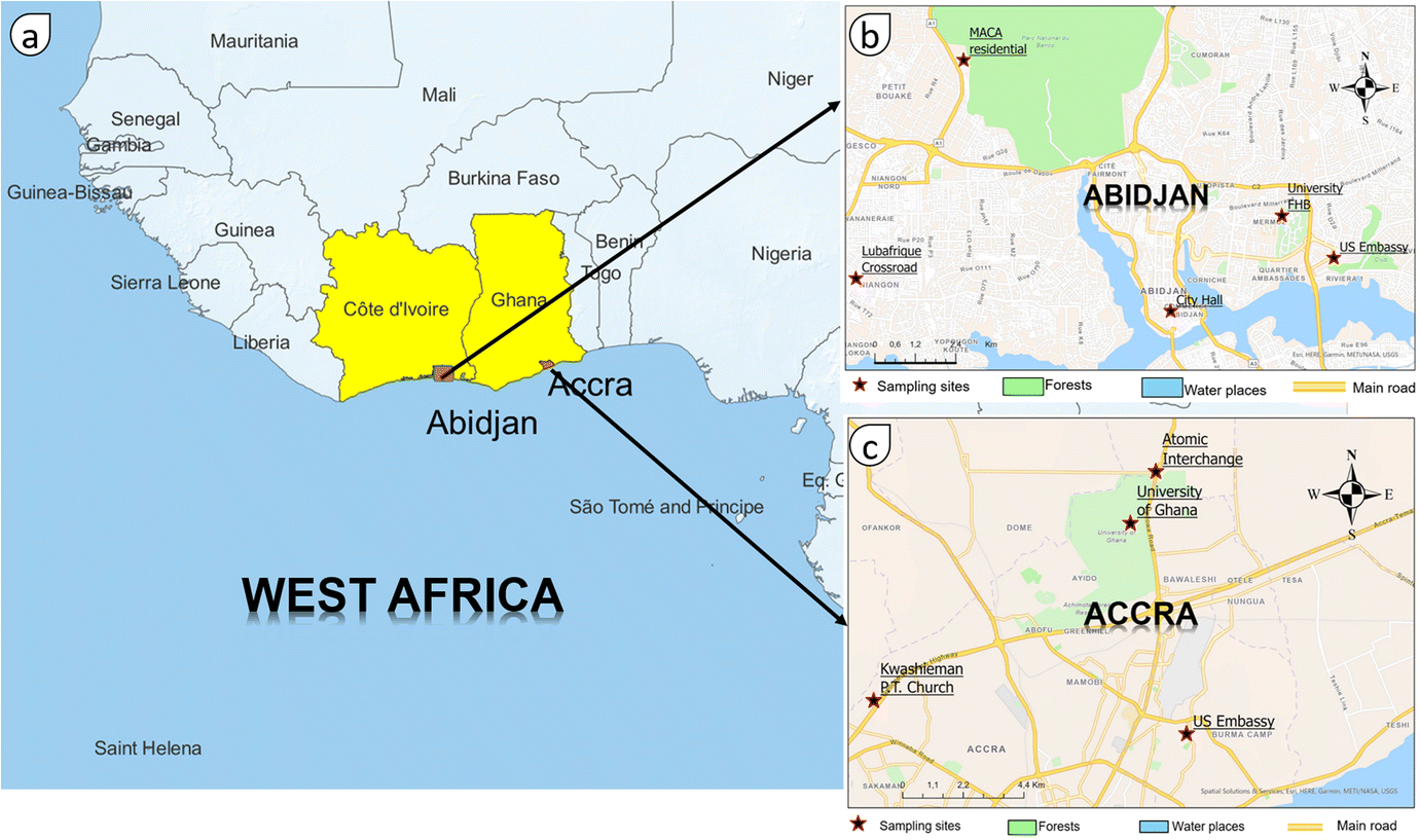 | ||
| Fig. 1 (a) Map of West Africa, (b) location of sampling sites in Abidjan (Côte d'Ivoire), (c) location of sampling sites in Accra (Ghana). | ||
2.1.1.1 U.S. Embassy in Abidjan (USEAB). The site of the US embassy in Abidjan (5°20′07′′N, 3°58′34 W) is located in the town of Cocody in the northeast of the district of Abidjan. Cocody is a high-income neighbourhood with a new and re-asphalted enlarged road network. This site is surrounded by a set of new roads and old renovated and enlarged roads. A roundabout regularly blocked by car traffic is located 230 m away, as well as a tollbooth less than one kilometre away. This site has a reference-grade monitor (Met One BAM-1022) installed by the US Department of State in early February 2020, and data are publicly available from Airnow International (https://www.airnow.gov/international/us-embassies-and-consulates/#Ivory_Coast$Abidjan, last accessed on 20/6/2023).
2.1.1.2 University Felix Houphouet-Boigny (UFHB). The UFHB site is also located in the town of Cocody at 5°20′48.268′′N latitude and 3°59′24′′W longitude. It is in a relatively clean urban environment, 500 m to the west of a large (10.35 ha) botanical garden – the National Center of Floristics, which is located inside the University. Aproximatively 180 m south of this measurement site is a smaller (1 ha) botanical garden. To the north and west of UFHB site are congested roadways especially during rush hour. RAMP120 and RAMP1036 were deployed at this location from February 2020. A Met-One BAM-1022 was also deployed there as part of the MOPGA/MAQGA “Make Air Quality Great Again” project in October 2020 and was used for calibration of the RAMP sensors (see Section 2.2.2).
2.1.1.3 Abidjan City Hall (ACH). Abidjan City Hall (5°19′15.83′′N, 4°1′11.36′′W) is a site mainly impacted by road traffic. It is located in the heart of the business center of the Plateau municipality in the center of Abidjan. The measurement site is about 20 m from the intersection of two main roads (the Avenue Delafosse and the Boulevard de la Republique). The flow of vehicles using these roads is usually high. Rush hour on these roads occurs between 6:00–9:00 (UTC, also Local Time, (LT)) and 16:00–20:00 (UTC).
2.1.1.4 MACA residential (MACA). The Residence MACA measurement site (5°23′18′′N, 4°04′31′′W) is located in a residential area in the northeast of the Yopougon industrial zone, near the western edge of the Abidjan agglomeration. This industrial area is the largest in Côte d'Ivoire in terms of surface area. There are several agro-food industries, chemical plants and cement production units.32 There is an incessant flow of large trucks loaded with various products at throughout the day. The vehicles are a major source of air pollution in this area due to the age and the lack of maintenance of these vehicles.33,34 This site is located at the western edge of the forest of the Banco National Park, which has an area of 3474 ha.35 This forest with large centennial trees is considered as the main hydraulic reservoir and the green lung of the city of Abidjan.36
2.1.1.5 Lubafrique crossroad (LUB). The Lubafrique crossroad (5°19′47.38′′N, 4°06′12.81′′W) is located in the sub-district of Niangon in the municipality of Yopougon. The measurement site is less than 10 m from the Lubafrique crossroad. It is one of the main crossroads that allows access to highly populated neighborhoods such as Niangon North, Niangon right, Cité Verte and Maroc. It is characterized by traffic jams throughout the day. It is mainly frequented by communal cabs called woro–woro. These old and rickety vehicles emit a lot of smoke and frequently break down.
2.1.2.1 Atomic interchange (AI). The atomic interchange site (5°40′04.3′′N, 0°10′38.5′′W) is located in the La-Nkwantang Madina Municipal Area close to Madina. Madina is 16 km from the center of Accra and is inhabited by low-income populations.37 The sensor was installed at about 40 m from the interchange placed on Legon road. This interchange spans the atomic junction roundabout and is located at the junction of Westland Boulevard Road and Haatso-Atomic Road. Legon road is a 2 × 3-lane freeway and the traffic is quite heavy throughout the day with peaks at rush hour (06:00, 12:00, 18:00 UTC).
2.1.2.2 University of Ghana (UG). The University of Ghana is located in Legon, a suburb which is 12 kilometers northeast of Downtown Accra. The university campus covers an area of about 1300 hectares. It is a large green space of which 25 hectares are occupied by the Legon Botanical Garden.38 The measurement site at the University of Ghana (5°39′04.1′′N, 0°11′08.3′′W) is located at the Department of Physics on the roof of a building at a height of 3 m from the ground and 200 m south of the Botanical Gardens. This site is relatively far from traffic, the nearest road with significant traffic is located at about 600 m to the east and can be considered as providing background levels. In addition to a low cost sampler, a Teledyne T-640 was deployed at this site in January 2021 as part of a World Bank-funded initiative in collaboration with Ghana EPA, University of Ghana and US EPA.39
2.1.2.3 Kwashieman Trinity Presbyterian Church (KTPC). Kwashieman is a town located in the Ablekuma North Municipal Area, which is one of 26 districts in the Greater Accra Region of Ghana. The Kwashieman Trinity Presbyterian Church site (5°35′40.2′′N, 0°16′10.4′′W) is located at the intersection of the N1 (George HW Bush Motorway), Kwashieman–Ofankor road and Kwashieman–Odorkor road. There are several commercial activities around this site including street hawking and vending, commercial cooking with biomass fuels, bar with charcoal grilling, gas filling station and bus stop.
2.1.2.4 U.S. Embassy in Accra (USEAC). The Accra US Embassy site (5°34′59.8′′N, 0°10′02.1W) is located in Cantonments, a high-income neighbourhood in the south of the city with very good road network and less commercial activities. This site is surrounded by major highways such as the second circular road to the north, the fourth circular road to the south, the fifth link road to the east and the old fort road to the west.
2.2 Measurement devices and PM2.5 model of calibration
 | ||
| Fig. 2 Pictures of monitors, (a) RAMPs at UFHB, (b) RAMPs at UG, (c) colocation of BAM-1022 and RAMPs at UFHB, (d) Teledyne T-640 at UG. | ||
In Accra, RAMP-1033 and RAMP-1034 were deployed from 10 March 2020 to 31 March 2021 at the atomic interchange (AI) and Kwashieman Trinity Presbyterian Church (KTPC) respectively. These two RAMPs were then later colocated for calibration with the University of Ghana's Teledyne T-640 from 01 April 2021 to 21 June 2021. Results of the collocation of RAMP1033 and RAMP1034 indicate again a high correlation coefficient R1033/1034 = 0.96 and show some Mean Normalised Bias of +0.04. Again, as for Abidjan, RAMP1033 was corrected with respect to RAMP1034 prior to calibration. Details on the deployments at the different measurement sites in Abidjan and Accra are summarized in Table 1.
| City | Measurement sites | Code | Instruments | Monitoring period | Land use |
|---|---|---|---|---|---|
| Abidjan | University Felix Houphouët-Boigny | UFHB | RAMP-1036 | 6 February 2020 to 26 May 2021 | Urban background |
| RAMP-120 | 24 March 2020 to 20 December 2020 | ||||
| BAM-1022 | 6 October 2020 to 26 May 2021 | ||||
| RAMP-1031 | 6 February 2020 to 20 February 2020 | ||||
| City Hall | ACH | RAMP-1031 | 20 February 2020 to 26 May 2021 | Traffic | |
| U.S. Embassy in Abidjan | USEAB | BAM-1022 | 6 February 2020 to 14 June 2021 | Traffic | |
| Maca city | MACA | RAMP-1036 | 1 June 2021 to 2 November 2021 | Urban background | |
| Lubafrique | LUB | RAMP-1031 | 1 June 2021 to 2 November 2021 | Traffic and residential | |
| Accra | University Ghana | UG | RAMP-1033/RAMP-1034/T-640 | 1 April 2021 to 21 June 2021 | Urban background |
| Atomic interchange | AI | RAMP-1033 | 10 March 2020 to 31 March 2021 | Traffic | |
| Kwashieman Trinity P. Church | KTPC | RAMP-1034 | 10 March 2020 to 31 March 2021 | Traffic and commercial | |
| U.S. Embassy in Accra | USEAC | BAM-1022 | 10 March 2020 to 31 March 2021 | Residential and traffic |
Data from the BAM-1022 units installed at the U.S. embassies in Abidjan and Accra were also used in this study. Data are available in the US EPA's open access database, at the Department of State's AirNow website.40 The data recoveries for the periods examined here are greater than 88%, except for RAMP-1036 during collocation at UFHB (62%) and for RAMP-1034 at the KTPC site (68%). Missing data are due to long interruptions in electricity supply, which prevented RAMP operation. Some measurements were removed from the database because they were either negative or below 1 μg m−3. For certain periods, embassy PM2.5 data were not available from the Airnow website.
| PM2.5(corrected) = 18.1746 + 0.88536 × PM2.5(RAMP) − 0.22924 × RH (Abidjan), | (1) |
| PM2.5(corrected) = 11.8294 + 0.907042 × PM2.5(RAMP) − 0.100319 × RH (Accra), | (2) |
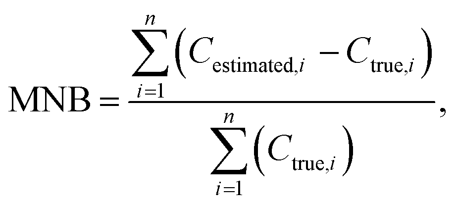
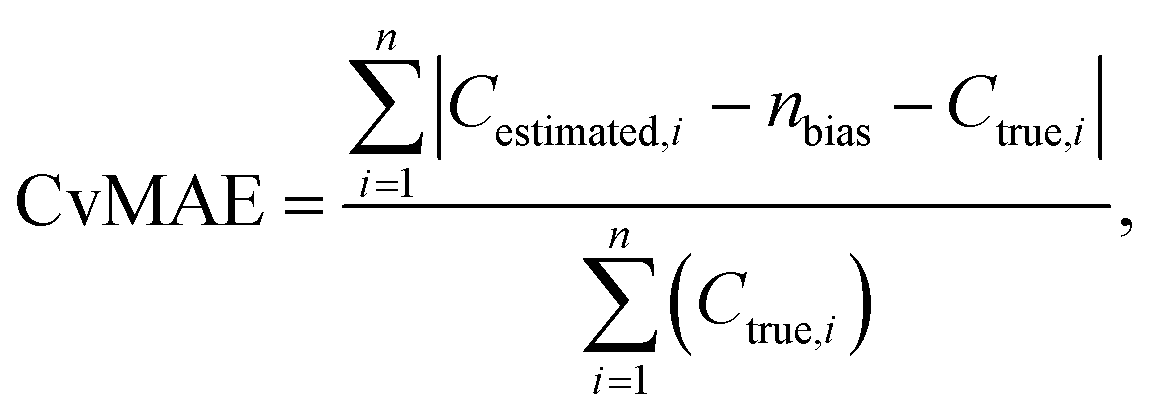
Using such relatively simple calibration models is recommended as a good practice by Giordano et al.23 Scatter plots in Fig. 3 gives the performance metrics of the models through the calculation of the Pearson linear correlation coefficient (R), the Mean Normalized Bias (MNB, eqn (3)) and the bias-corrected Coefficient of variation of Mean Absolute Error (CVMAE, eqn (4)).
 | (3) |
 | (4) |
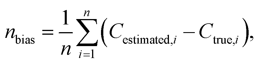 | (5) |
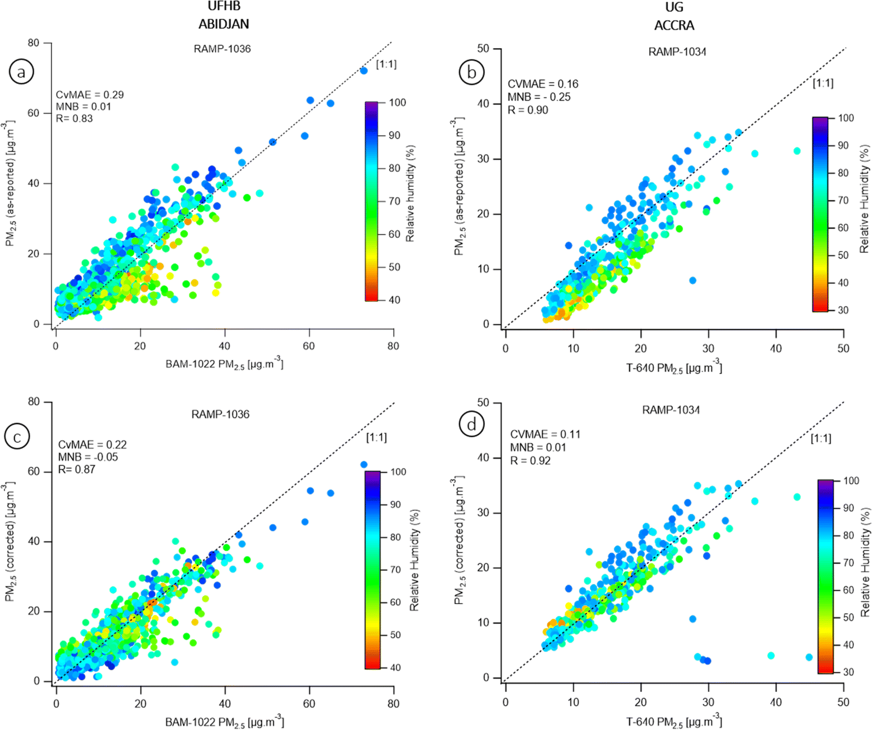 | ||
| Fig. 3 Comparison of 1 h-average RAMP-1036 (a) and RAMP-1034 (b) sensor readings to reference instruments BAM and T-640 during collocations at the UFHB site at Abidjan and UG site at Accra respectively. Shades (colors) indicate RH at the time of the measurement. | ||
The results indicate that the models further improve the correlation coefficients between the data provided by the reference instruments and the raw data provided by the RAMPs and minimize the errors (CVMAE and MNB). The same calibration model has been used for both the dry and wet seasons. The Abidjan (eqn (1)) and Accra (eqn (2)) calibration models were used to correct all the RAMPs data in the given city.
In the following sections, since the UFHB and UG sites have several measuring instruments installed, only the corrected results from RAMP-1036 and RAMP-1034 will be used.
3 Results and discussion
3.1 Diurnal and intra-urban variability of PM2.5 across Abidjan and Accra
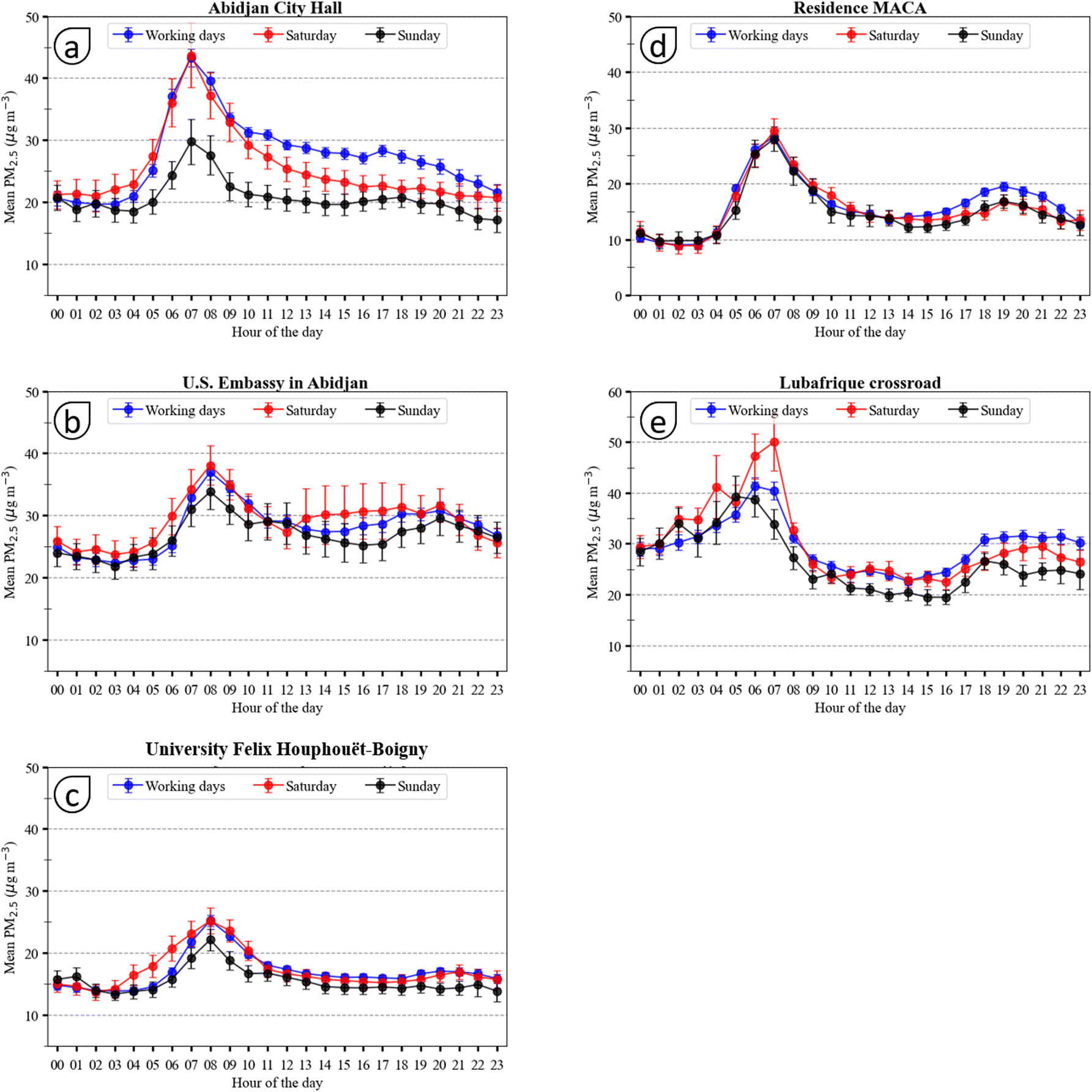 | ||
| Fig. 4 Diurnal variation of PM2.5 mean concentration in different sites in Abidjan (a) ACH, (b) USEAB, (c) UFHB, (d) MACA, (e) LUB, during weekdays (Monday to Friday), Saturdays and Sundays. Error bars represent standard error. | ||
At the MACA site (Fig. 4d), the work of Doumbia et al.34,41 showed that the flow of vehicles on the secondary roads reached its maximum (7000 vehicles per hour) between 7:00–9:00 UTC. This closely corresponds to the PM2.5 peak observed at 7:00 UTC at this site. In addition to the heavy traffic recorded on the roads, it is important to note that the vehicle fleet is very obsolete: it is mainly made up of minibuses commonly called “gbaka” and communal cabs called “woro–woro”. These vehicles, which are able to evade emissions controls, emit a lot of smoke and therefore black carbon and organic aerosols in the PM2.5 size fraction. In addition to the diurnal variation in emission sources, several studies have indicated that the height of the boundary layer also modulates pollutant concentrations.42–45 During the DACCIWA experiment in West Africa (2014–2018), a low (about 150–300 m a.s.l) and stable atmospheric boundary layer was observed in the morning from LIDAR measurements46 limiting dispersion of locally emitted pollutants leading to locally higher concentrations. A decrease in pollutant concentrations is observed during noon hours, when the boundary layer height increases and vehicular emissions are lower.
These concentration peaks are not observed in the late afternoons/evenings at some locations (Fig. 4a–c), although traffic of similar intensity occurs. However, the traffic jams are spread out over time, which tends to keep PM2.5 concentrations rather similar between 17:00–21:00 UTC. Significance tests (t-test) of the differences between the hourly PM2.5 concentrations presented in Table S2 in the ESI† indicate that there is no significant difference between the average PM2.5 concentrations measured at 16:00 UTC and at 19:00 UTC.
In the residential municipality of Yopougon (Fig. 3d and e), significant PM2.5 concentrations peaks are observed at 19:00 UTC during working days only at the two sites: LUB (30 μg m−3) and MACA (20 μg m−3). At this time of the day households are cooking their dinner, so domestic fires could be an additional source of PM2.5 as shown by Bahino et al.47 Charcoal wood and wood are the main fuels used for cooking at LUB and in the residential zone of Yopougon where MACA is located.32 For these last two sites, we note that the roads located in the vicinity are less well maintained and very often covered with dust. Moreover, heavy vehicles, which circulate in the industrial zone, quickly damage the roads and generate particles. Especially for these sites, the resuspension of dust by the wheels of vehicles could constitute an additional source of PM2.5, even if this type of emissions mostly affects coarse particles above 2.5 μm diameter.16
The comparison of the measurement sites shows differences and similarities. During weekdays and Saturdays, the concentrations measured at ACH and USEAB are of the same order of magnitude throughout the day. The major difference is observed at the time of the peak at 7:00 UTC with PM2.5 concentration in ACH 8 μg m−3 larger than at USEAB. Interestingly, the ACH site shows the largest difference with higher morning peaks at 7:00 UTC between weekdays/Saturdays (44 μg m−3), and Sundays (30 μg m−3) among all studied sites monitored in Abidjan. This is due to smaller activity on Sundays in the neighbourhood of this site, which groups administrations and economic activities, and in the town center in general. In contrast, differences between days of the week are weak for the MACA site located in a residential area with more homogeneous activity throughout the week. During workdays and daytime, PM2.5 concentrations at ACH are nearly two times higher than those measured at UFHB site (Fig. 4a and c).
These differences indicate large disparities in local pollution. An urban background site as UFHB is less exposed to particulate pollutants and shows lower values than a traffic site as ACH. In contrast, the ACH and USEAB sites are more influenced by vehicular traffic.
At the LUB and MACA sites, the concentration differences vary according to the time of day. Between 00:00–4:00 UTC the difference is almost constant and the concentrations at LUB are nearly 3 times higher than at MACA. This difference reduces progressively from 5:00 UTC to reaches a minimum at 7:00 UTC. The average concentrations are then two times higher than those measured at MACA. This difference extends during daytime and even increases after until 19:00 UTC. These features can be due to the decrease in the intensity of the traffic source at MACA between 21:00–4:00 UTC. LUB, on the other hand, remains busy with vehicles for longer periods during the night. On Saturdays in Lubafrique, PM2.5 concentrations are particularly high between 00:00 and 4:00 due to the late opening of pubs, nightclubs and restaurants.
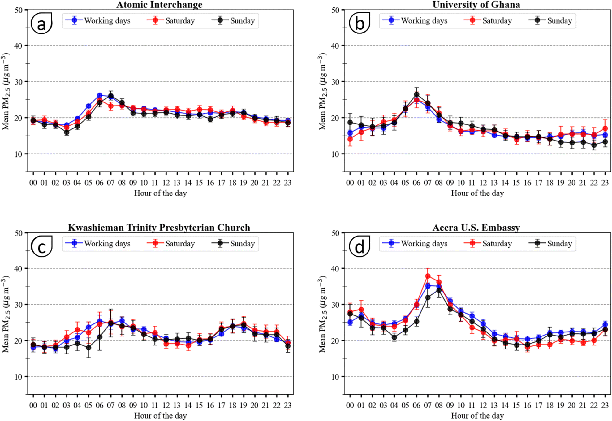 | ||
| Fig. 5 Diurnal variations of PM2.5 mean concentration in different sites in Accra during weekdays (Monday to Friday), Saturdays and Sundays. (a) Atomic Interchange, (b) University of Ghana, (c) Kwashieman Trinity Presbyterian church and (d) Accra US embassy. Error bars represent standard error. | ||
This also holds for Saturdays and Sundays except at the University of Ghana (UG) and Kwashieman Trinity Church (KTPC) where this variation is not significant (p > 0.05). Compared to the measurement sites in Abidjan, the peaks measured in Accra tend to appear a little earlier, around 6:00 UTC. The University of Ghana Lagoon and the Atomic Interchange junction sites are approximately 2.7 km apart. Although the University of Ghana is classified as a background site, its proximity to nearby traffic (e.g. university employees) combined with boundary layer dynamics and local meteorology can lead to higher local PM2.5 as it does at the traffic junction. To confirm this hypothesis, a comprehensive analysis of wind direction variations and local traffic patterns is necessary, which could be investigated in future work.
It is interesting to note, that diurnal variations are rather similar with respect to the type of the day within ±4 μg m−3 in general, small hourly shifts in the morning peak in average of 1 h are observed.
The average peak concentrations of fine particles measured at the sites in Accra on weekdays are 35.2 μg m−3, 25.5 μg m−3, 26.2 μg m−3 and 25.7 μg m−3 respectively at USEAC (Fig. 5d), KTPC (Fig. 5c), AI (Fig. 5a) and UG (Fig. 5b). On Saturdays, 38.0 μg m−3, 25.1 μg m−3, 24.9 μg m−3 and 25.0 μg m−3 were measured respectively. While at KTPC, AI and UG sites concentrations are rather similar around 25 μg m−3, they are larger for USEAC (35–38 μg m−3). Comparing these values to those for Abidjan (20–42 μg m−3), we can state that the variability between sites within a city is larger than the differences among both cities.
The KTPC site is the only one in Accra for which a significant concentration peak is observed in the evening of working days at 19:00 UTC. In addition to traffic emissions from the busy road network near the site, there are commercial activities at the site especially the grilling of fish and meat seems to peak around that time. This site is similar to that of Lubafrique crossroad in Abidjan where an evening peak was also observed. The presence of activities using wood and charcoal seems to constitute an additional pollutant source resulting in an evening peak.
At most sites in Accra, as opposed to Abidjan, the highest concentrations on Sundays are one to two hours later than on weekdays and Saturdays. This suggests a delay in the beginning of polluting activities. At AI (26.1 μg m−3), and KTPC (24.83 μg m−3) the peaks are observed at 7:00 UTC while they are observed at 8:00 UTC at USEAC (31.9 μg m−3). Mean PM2.5 values measured at KTPC between 5:00–7:00 UTC have fairly high standard deviations. This points to varying pollutant sources and/or to dispersion conditions.
All these sites (AI, KTPC, USEAC) are influenced by road traffic with measurements at USEAC site showing the highest morning concentrations and then traffic related peak. In contrast, the site located at the University of Ghana in Accra is a little more isolated and relatively uninfluenced by nearby pollutant emissions from traffic. This site is located near the botanical garden of the university and surrounded by large trees. The hourly average concentrations measured here are low compared to those at other sites in Accra. They range from [14.0–25.7 μg m−3] on weekdays, [14.0–25.0 μg m−3] on Saturdays and [11.5–26.5 μg m−3] on Sundays. The highest hourly concentrations measured in Accra are at the sites influenced by road traffic (USEAC, AI) and to a lesser extent the KTPC site. PM2.5 concentrations at USEAC are particularly high not only for the morning peak, but also, they remain above 20 μg m−3 between midnight to noon also during Sundays. From 13:00 UTC to 23:00 UTC, the measured concentrations are practically equal and constant around 20 μg m−3 on all these sites.
3.2 Distribution of daily PM2.5 concentrations in Abidjan and Accra and comparison with WHO guidelines
For the majority of sites (ACH, UFHB, AI, USEAC), the data sets collected are symmetrical around the mean. However, for the USEAB, KTPC and USEAC sites, the larger means than medians indicate the occurrence of large concentrations that can be seen in Fig. 6. The study of the data dispersion indicates that the interquartile range (IQR) is very different from one site to another with values of 12.2 μg m−3, 8.8 μg m−3, 10.6 μg m−3, 6.8 μg m−3, 14.1 μg m−3, and 8.8 μg m−3 respectively for ACH, UFHB, USEAB, AI, KTPC, USEAC. However, the relative interquartile range (IQRr) indicates a similar dispersion of data at the Abidjan sites with IQRr ∼ 0.5. IQRr calculated for the Accra sites gives 0.3, 0.7 and 0.4 for AI, KTPC and USEAC respectively.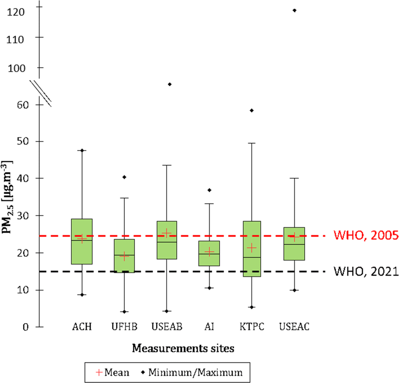 | ||
| Fig. 6 Statistical distribution (min, 25th percentile, median, mean, 75th percentile, max) of PM2.5 concentration in Abidjan and Accra sites. Dotted red and black lines represent the daily threshold from WHO air quality guidelines global update 2005 and 2021 respectively. | ||
Firstly, it can be seen from Fig. 6 that the annual mean concentrations of PM2.5 measured at the sites in Abidjan show real differences with maximum at sites strongly influenced by traffic as seen at USEAB (25.5 μg m−3) and ACH (23.9 μg m−3), versus those more isolated from road traffic like UFHB (19.0 μg m−3). In Accra, no significant difference was identified between KTPC (21.4 μg m−3) and AI (20.4 μg m−3) although the sources for these two sites were different (see Table 1). The highest average concentration was measured at the USEAC traffic site with 24.5 μg m−3. The annual average PM2.5 thresholds defined by the WHO in 2005 (10 μg m−3) and 2021 (5 μg m−3) were largely exceeded at all sites in Abidjan and Accra. Time series of daily PM2.5 concentrations in Abidjan and Accra are presented in Fig. 7a and b, respectively. Concentrations ranged from 4.2 μg m−3 to 93.2 μg m−3 in Abidjan and from 5.4 μg m−3 to 122 μg m−3 in Accra. The lowest concentrations were usually observed at sites with low vehicular traffic impact such as UFHB in Abidjan and KTPC in Accra. Sites close to roads such as ACH and USEAB in Abidjan or USEAC and AI have the highest PM2.5 average concentrations. It can be seen that for a given city, the daily variations of PM2.5 are similar for all sites, with the exception KTPC site.
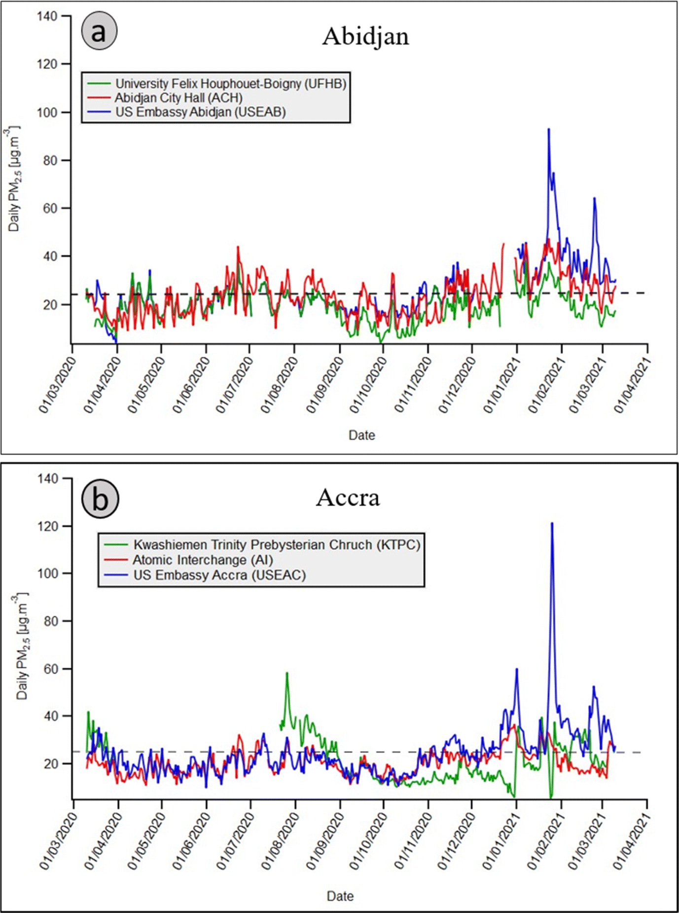 | ||
| Fig. 7 Variability of daily average PM2.5 concentration in measurement sites in (a) in Abidjan and (b) in Accra. Dotted black line represents the 2005 WHO daily threshold. | ||
To allow for easy comparisons between sites, this analysis is based on data collected over the period between March 2020 and March 2021 when the majority of sites were simultaneously instrumented. Daily average concentrations and their distribution were calculated from hourly average concentrations. The database summarized in Table 2 consists of 360, 343, 324 days of daily average PM2.5 obtained at ACH, UFHB, USEAB in Abidjan and 359, 366 and 248 days of daily PM2.5 in AI, USEAC, KTPC in Accra, respectively.
| Measurements sites in Abidjan | Measurements sites in Accra | |||||
|---|---|---|---|---|---|---|
| ACH | UFHB | USEAB | AI | KTPC | USEAC | |
| J | 360 | 343 | 324 | 359 | 248 | 366 |
| J 25 | 157 | 60 | 127 | 60 | 85 | 133 |
| % J25 | 44% | 17% | 39% | 17% | 34% | 36% |
| J 15 | 306 | 250 | 300 | 310 | 168 | 328 |
| % J15 | 85% | 73% | 93% | 86% | 68% | 90% |
The variability in daily average PM2.5 concentrations calculated at each site is presented in the Fig. 5 where the box plots indicate the min, 25th percentile, median, mean, 75th percentile and max over the study period.
The number of daily concentration peaks above WHO thresholds (25 μg m−3 (J25) in 2005 and 15 μg m−3 (J15) in 2021), varies according to the measurement sites in Accra and Abidjan. Table 2 shows the number and percentage of daily concentration above WHO thresholds (% J25 and % J15) for each measurement site. According to WHO threshold of 25 μg m−3 in Abidjan, the site of highest concern is ACH with 157 days above the threshold (i.e. over 43% of the year). At the US Embassy in Abidjan, there were 127 days of measurements above the threshold for 365 days of data, i.e. 39% of the days. The UFHB site is less exposed with only 60 days exceeding (i.e. 17.4%).
For the measurement sites in Accra, KTPC and USEAC had more than 34% days of the year with pollution levels above the 25 μg m−3 threshold. With the high population living in both cities, this indicates that millions of people are subject to particulate pollution exposure above daily WHO thresholds. The results are even more alarming when looking at the number of days that the new threshold (15 μg m−3) from the WHO Air quality Guideline of 2021 is exceeded. The new threshold is exceeded almost every day at the different sites. In Abidjan there are between 250 (73%) and 306 (85%) days during the year where the levels are exceeded whilst in Accra this is between 168 and 328 days. This represents between 68% and 90% high pollution days in the year. The exposure of populations to these many days of pollution has the potential to increase the risks of adverse health outcomes especially respiratory and cardiovascular symptoms. In addition, there are several consecutive pollution days during the dry season, which further exacerbates the health risks. To determine what causes high pollution days, we performed a case study on an episode observed in January 2021.
3.3 Seasonal PM2.5 concentration in Abidjan and Accra
Fig. 8 shows the seasonal variations of PM2.5 concentrations and their distribution at the Abidjan and Accra sites. The study of seasonal variations in Abidjan and Accra indicates that the highest average concentrations (between about 20 to 40 μg m−3) were in general measured during the long dry season (LDS, from December to February). This is particularly true for the sites impacted by vehicular traffic, while for the urban background sites, UFHB in Abidjan, the highest concentrations are encountered during the long wet season (LWS) from March to July.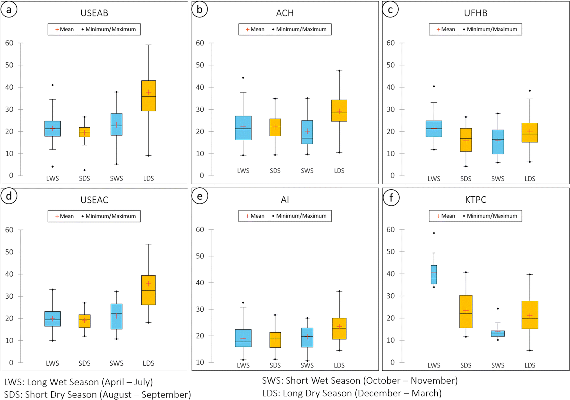 | ||
| Fig. 8 Seasonal variations of PM2.5 concentrations at different sites in Abidjan (a) USEAB, (b) ACH, (c) UFHB)) and Accra (d) USEAC, (e) AI and (f) KTPC. | ||
The spread between the P10th and P90th percentiles for the different sites also depends on the seasons. It is largest for LDS, with spreads between 10 and 60 μg m−3 for the different sites. For the other seasons and sites, concentrations ranges are lower, from less than 10 to about 40 μg m−3 for the different sites, with an exception of higher vales at the KTPC site.
Seasonal differences in PM2.5 averages and distributions could be due to several reasons. Enhanced precipitation in the long and short wet seasons (LWS, SWS) can lead to increased removal of particulate matter. Fig. S2† indicates the different precipitation amounts (and dates of events) at Abidjan and Accra, and illustrates the choice of the different seasons. Both Fig. 8 and the time series in Fig. 7a and b show that the highest PM2.5 concentrations occurred during the long dry season from December 2020 to February 2021. This could be in principle due to seasonal variability in local emissions, but we have no indication for such a hypothesis. An alternative hypothesis might be advection from outside the cities. At this time of year, the West African coast is often subject to the continental flow of dust from the Sahara desert that sweeps across the Gulf of Guinea. This dust-carrying flow of hot, dry air is known locally as the Harmattan.48 To better understand some of the observed pollution peaks, we will analyse in the next section available satellite AOD (aerosol optical depth) measurements and air masses origin through trajectory analysis.
3.4 Case of suspected dust pollution over Abidjan and Accra
In January 2021, in the middle of the long dry season, a prolonged episode of high PM2.5 concentrations was observed. Fig. 9 shows the daily concentrations of PM2.5 between the 10th and 31st of January 2021.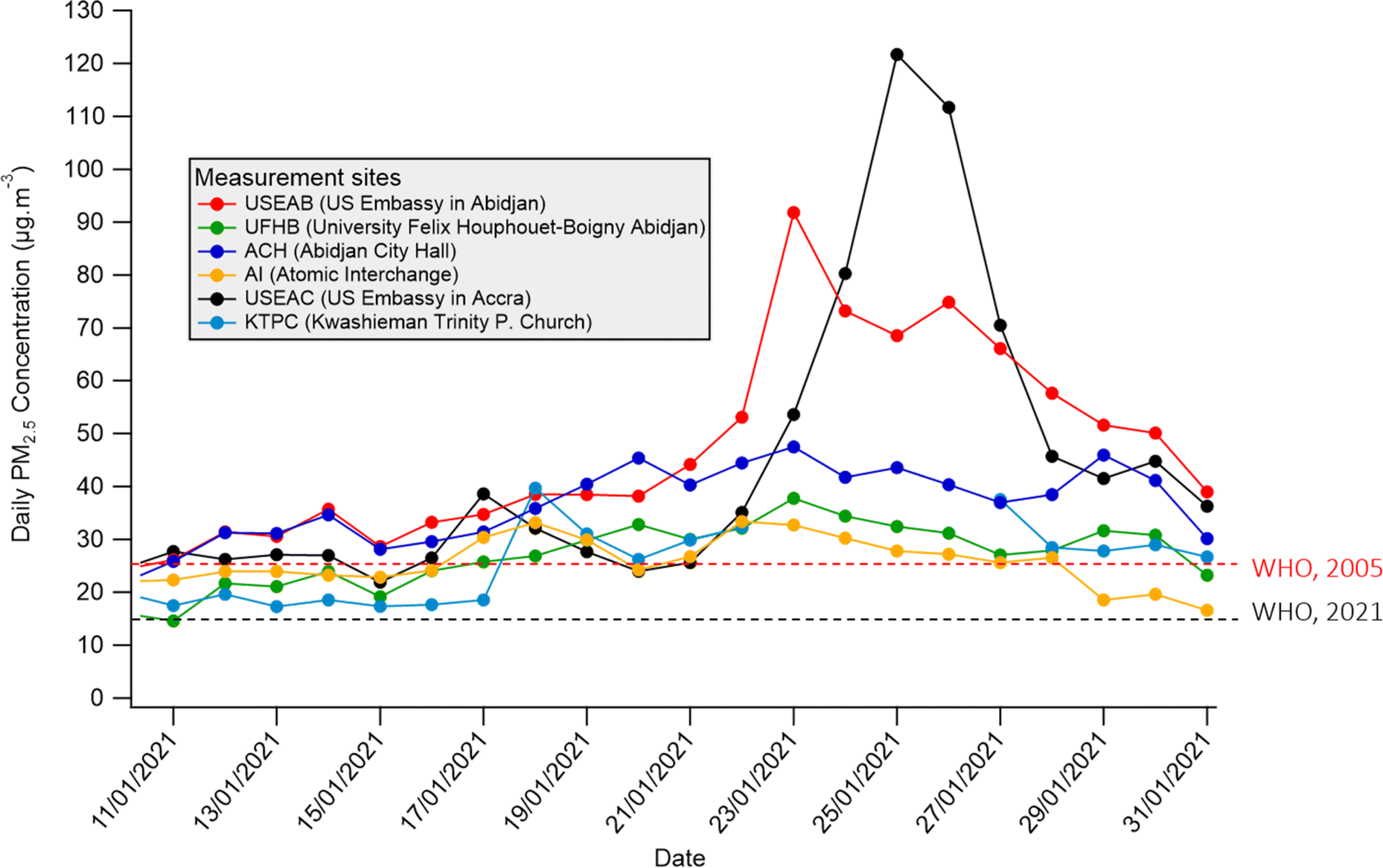 | ||
| Fig. 9 Evolution of the daily average concentration of PM2.5 between the 10th and 31st of January 2021. Dotted red and black lines represent the daily threshold from WHO air quality guidelines global update 2005 and 2021 respectively. | ||
Between the 18th–28th of January 2021, there were nearly 10 consecutive days where the threshold of 25 μg m−3 (WHO, 2005) was exceeded at all the measurement sites in Abidjan and Accra. The high values of measured PM2.5 concentrations, their frequency and the extent of the affected measurement sites in both cities suggest that this is a regional pollution episode affecting the southern part of West Africa located in the Gulf of Guinea. This hypothesis has already been formulated and established in several previous studies.49–53 In addition, Wang et al. 2022 (ref. 54) using the HYSPLIT model recently explored this question in Accra.
The reference-grade PM2.5 monitors in Abidjan and Accra in particular report significantly higher concentrations between 22nd–28th of January compared to the RAMP sensor networks. This could be related to the type of pollution impacting the city during this time, as studies have shown that nephelometric low-cost PM sensors (as used in the RAMP) have poor detection efficiency for particles over 1 μm,55,56 as would be the case for dust pollution. Hence, we hypothesize that this region could have received dust from the vast Sahara desert located northeast of Abidjan and Accra.
To verify this hypothesis, we first looked at the air mass back-trajectories arriving in Abidjan and Accra during seven consecutive days around the date of 23 January 2021 when the highest daily PM2.5 concentration (91.8 μg m−3) was measured in Abidjan.
These back-trajectories made from the Hysplit model57–59 available online on the National Oceanic and Atmospheric Administration website (https://www.arl.noaa.gov/hysplit/) are shown in Fig. 10. Back-trajectories are calculated 96 hours backwards at three different receptor heights (500 m, 1000 m and 1500 m). Between 20th–22nd January 2021, back-trajectories arriving at 500 m and 1000 m and over Abidjan and Accra came directly from the Atlantic Ocean, in line with the prevailing climatological SW winds for both cities. At 1500 m, back-trajectories coming from the Atlantic Ocean were transiting through the land before ending up over the two capitals.
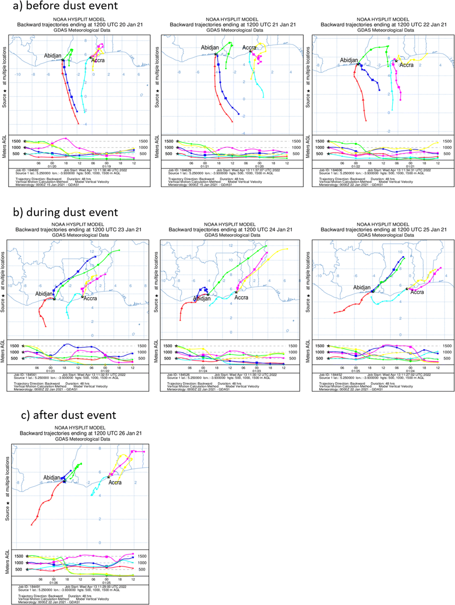 | ||
| Fig. 10 96-hours Hysplit back-trajectories of wind fields for Abidjan and Accra between the 20th and 26th of January 2021, at 12 UTC, at different periods: (a) before the dust event, (b) during the dust event and (c) after the dust event; receptor points are for three different altitudes, 500 m (red and cyan), 1000 m (blue and red) and 1500 m (green and yellow), respectively. | ||
On 23rd January 2021, we observe a reversal of the winds arriving 1000 m and 1500 m above Abidjan and Accra. They now suggest that the winds come mainly from the Northeast (trade winds) where the great Sahara desert is located. Even if after 4 days, many of the back-trajectories in NE direction do not reach the Sahara, the probability is elevated that they originate there, as they are imbedded in the trade wind (NE winds) system. Although winds coming from an altitude of 500 m are of oceanic origin, vertical mixing of air masses could lead to an increase in surface PM2.5 concentrations measured that day. This situation continues the following days until 25th January 2021. On 26th January 2021, air mass trajectories for Abidjan arrive from Atlantic ocean, after a rapid excursion over land, while they still originate from NE for Accra (at 1000 m and 1500 m height). The largest surface PM2.5 levels observed at Accra and Abidjan and the still enhanced values for the following days clearly correspond to the air mass trajectory origin over the continental areas and possibly over the Sahara. Interestingly, this holds only for trajectories at 1000 m and 1500 m.
To further characterize this regional dust origin, we examined Aerosol Optical Depth (AOD) satellite images provided by the Visible Infrared Imaging Radiometer Suite (VIIRS) instrument aboard the joint NASA/NOAA Suomi National Polar-orbiting Partnership (Suomi NPP) and NOAA-20 satellites. Fig. 11 illustrates the AOD changes across southern West Africa from January 20th to January 26th, 2021. Enhanced AOD levels above 1.2 are present in NE of Accra on 20 and 21 January 2021; they strongly intensify on 22 January 2021 (AOD above 1.8) and reach Accra and Abidjan on 23 January 2021.
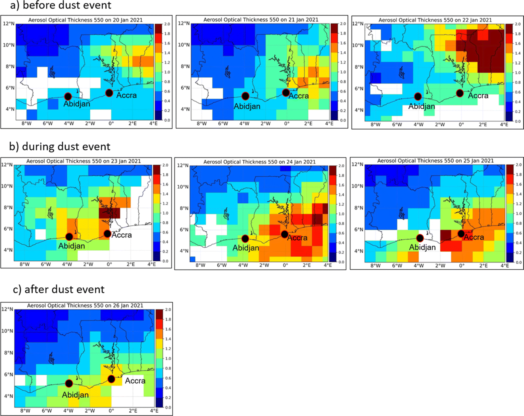 | ||
| Fig. 11 AOD over Abidjan and Accra between the 20th and 26th of January 2021, provided by the Visible Infrared Imaging Radiometer Suite (VIIRS) instrument. (a) Before the dust event, (b) during the dust event, (c) after the dust event. | ||
Correspondingly, the AOD increased progressively over these cities until reaching a maximum between 1.4 and 1.6 on 23 January 2021 at Abidjan. The AOD then decreased at Abidjan down to between 0.8 and 1 on 26 January 2021. In contrast to Abidjan, the AOD in Accra continued to increase on 24 January 2021 and reached its maximum on January 25. These results are in agreement with the field observations presented in Fig. 9 showing PM2.5 maxima on 23 January 2021 at Abidjan and on 25 January 2021 at Accra. This suggests that dust loaded air masses advected in altitude are mixed with marine air masses advected near surface. Fig. 12 shows the AOD observation at different altitudes and indicates that there are dust plumes at 1 km and 2 km that could be mixing with surface emissions.
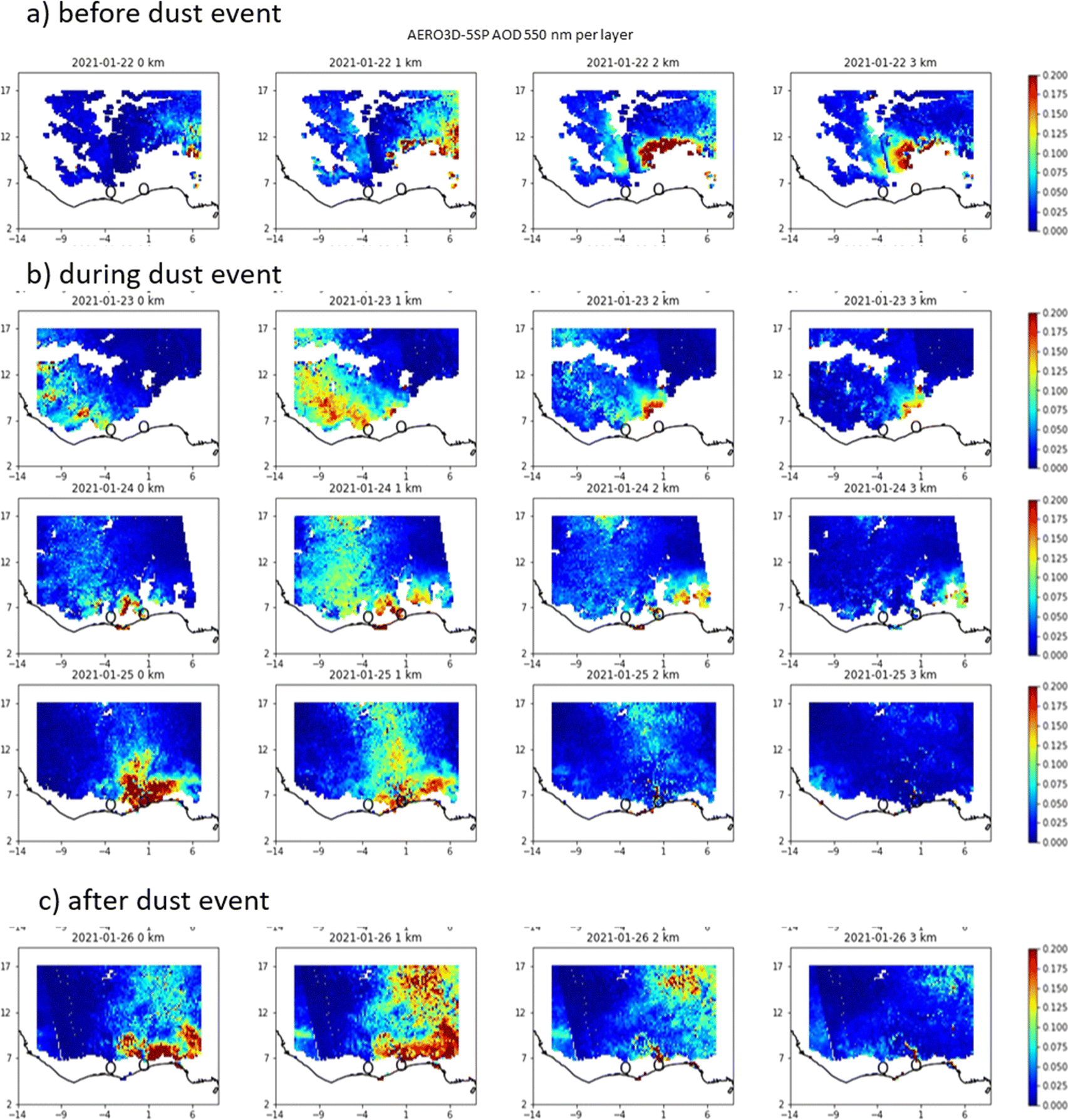 | ||
| Fig. 12 Satellite retrieval observation of the AOD at different altitudes over West Africa from January 22 to 26, 2021 using TROPOspheric Monitoring Instrument (TROPOMI) as done in (Lemmouchi et al. 2022).50 (a) Before the dust event, (b) during the dust event, (c) after the dust event. | ||
This differential advection has already been observed during the DACCIWA campaign (2014–2017).14 The fact that this mechanism still holds for 24 and 25 January 2021 could explain the many days of elevated PM2.5 levels observed after 23 January 2021.
As a conclusion of this section, the observations of the back-trajectories and satellite measurements of AOD, tend to show that in this period of dry season, the high measured concentrations of PM2.5 may be the result of a regional dust contribution, in addition to local pollution. Dust from the Sahara desert in the north can therefore remain suspended in the atmosphere for a long time and then impact the concentrations measured at sites further south in the Gulf of Guinea.
3.5 Annual average concentration of PM2.5 in West Africa
Fig. 13 shows the annual mean concentrations of PM2.5 measured at 40 sites in eight West African countries for a study period of at least one year, over the last 20 years (further details in Table S4, ESI†). Unfortunately, very few studies are conducted on an annual basis in this part of Africa. In the cities located in the Sahel and under the influence of the Sahara desert dust, only one study was carried out between February 2020 and March 2021 in Balkuy (Ouagadougou) in Burkina Faso and another one on a traffic and industrial site in Dakar (Senegal)5 between 2010 and 2018.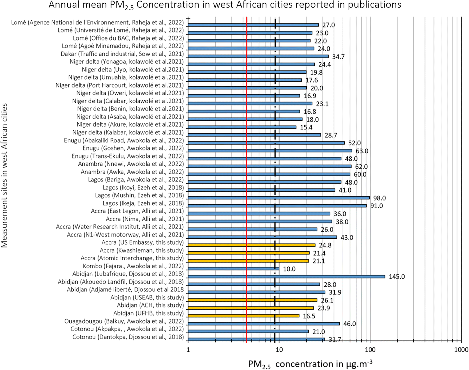 | ||
| Fig. 13 Annual average of PM2.5 concentrations in West African cities reported in the publications between 2001 and 2022 (blue bars) and in this study (yellow bars). The red line and the dotted black line represent the WHO air quality guideline values for the years 2021(5 μg m−3) and 2005(10 μg m−3) respectively. | ||
The annual average PM2.5 thresholds defined by the WHO in 2005 (10 μg m−3) and 2021 (5 μg m−3) are largely exceeded at all sites in Abidjan and Accra. These thresholds are also largely exceeded at the 34 other sites that have been annually monitored over the last 20 years between 2001 and 2022. The highest PM2.5 concentration (145 μg m−3) was measured during the DACCIWA campaign (February 2015–March 2017) at a Abidjan domestic fires site.15 This study reports measurements close to strong sources; however, such a near-source site, even if may be not representative for larger areas, still documents exposure of population to air pollution. Measurements carried out at the industrial site of Ikeja (91 μg m−3) and at the high density residential site of Mushin (98 μg m−3) in Lagos (Nigeria) indicate significantly degraded air quality.60 For 85% and 100% of the investigated sites, the annual average PM2.5 concentrations were more than two times the 2005 (10 μg m−3) and 2021 (5 μg m−3) WHO air quality guideline respectively. This result is quite concerning and should lead West African political authorities to pay more attention to the air quality issue, with air quality management efforts focused on reducing sources of air pollution.
In our study, the mean annual concentrations recorded at different monitoring sites in Accra between February 2020 and March 2021 ranged from 21.1 μg m−3 to 24.8 μg m−3. These levels are slightly lower than those reported by Alli et al. (2023) between April 2019 and June 2020, which ranged from 26 μg m−3 to 43 μg m−3. In addition, this study by Alli et al.2023 showed a notable 50% decrease in annual concentration levels compared to measurements taken between 2006 and 2007, which ranged from 37 μg m−3 to 71 μg m−3. This confirms a consistent downward trend in PM2.5 levels following the implementation of abatement measures. However, levels are still higher than the WHO annual threshold. Our research in Accra yielded similar results to Alli's, particularly with regard to high concentrations during the dry season, influenced by the harmattan flow.
4 Conclusions
In this study, we deployed field calibrated low-cost sensors in Abidjan, Côte d'Ivoire and Accra, Ghana, the capitals of two fast growing economies in West Africa, for a period of over a year and also used available reference-grade data. For these two cities, low-cost sensor data has been corrected through collocation with reference-grade instruments and specific calibration models have been built. The data were used to study spatial and temporal (diurnal, daily, seasonal) variations and annual mean of PM2.5 concentrations for each city.Both cities showed a peak in the mornings between 7:00–8:00 AM (UTC, also local time). Significant differences occur between weekdays and Saturdays on the one hand and Sundays on the other in both Abidjan and Accra. The highest hourly average concentrations were measured on weekdays and Saturdays with values between 25 μg m−3 and 50 μg m−3 in Abidjan and between 26 μg m−3 and 38 μg m−3 in Accra. These morning peaks are associated with traffic congestion as well as with the height of the atmospheric boundary layer and the stability of the atmosphere. Evening peaks at sites in residential areas are thought to be related to residential emissions. Daily average concentrations in Abidjan range from 4.2 μg m−3 to 93.3 μg m−3 while in Accra they range from 5.4 μg m−3 to 122 μg m−3. The highest concentrations were measured in December 2020 and January 2021 in the middle of the dry season. Around this period, several consecutive days recorded PM2.5 exceeding the 2021 WHO pollution threshold of 15 μg m−3. Over the total campaign of 366 days, for all the sites of measurements, we recorded between 60 and 157 days of levels exceeding the 2005 WHO daily threshold61 (25 μg m−3), which represents between 17% and 44% of the year being highly polluted. This percentage is even higher when comparing the measured PM2.5 concentrations to the new daily threshold62 of 15 μg m−3, from a minimum of 168 (68%) days at KTPC and a maximum of 328 (90%) days at USEAC. The fact that the majority of these pollution episode days are concentrated during the dry season has led us to study the influence of regional advection on the concentration levels. The West African region is under the influence of dust from the northeast where the Sahara desert is located. Back-trajectories and satellite data of the AOD over the region show regional dust transport in the direction of Abidjan and Accra, adding to local sources. As a note of caution, it was observed that dust-dominated pollution episode was not as well-captured by nephelometric PM sensors, indicating the need for hybrid networks consisting of both reference monitors and low-cost sensors.
Annual PM2.5 concentrations in Abidjan and Accra ranges between 17 μg m−3 to 26 μg m−3 and 21 μg m−3 to 25 μg m−3 respectively, the larger values obtained at sites impact by heavy vehicular traffic. These values are in the same range as some other West-African cities with a population of 1–5 million inhabitants (with values from 22 to 32 μg m−3). Accra has been extensively studied to characterize its air quality, while Abidjan lacked comparable research in this area. As a general result, our study has then allowed pointing out various similarities between both cities in terms of PM2.5 pollution levels, their seasonality, day to day variability, and diurnal variation, even if quantitative differences occur. Nevertheless, we found that differences between different types of sites (urban background, traffic, residential) were larger than differences between the cities. In addition, More long-term studies are urgently needed to improve the understanding of air quality in both cities, especially in Abidjan. In particular, such measurements would allow tracking the impact of growing urbanization in both cities on air quality. Investigating differences within cities including near source measurements is relevant for population exposure to air pollution and requires deploying a large number of instruments. Permanent monitoring networks would contribute to improving air quality data access in this region. This would both allow to better evaluate differences in fine PM2.5 levels between different cities, but also within a given city, where differences can be extremely large. Considering this would require a large number of measurement sites, the use of well-calibrated low-cost sensors, as used here, would be a good alternative to traditional, expensive regulatory grade monitors for such monitoring networks.
Even if our paper does not provide a quantitative assessment of pollution sources contributing to the encountered PM2.5 concentrations, it does give qualitative hints. Depending on the site type, vehicular emissions, resuspended road-dust, and residential cooking can be important contributors to ambient air pollution in Abidjan and Accra. This gives some guidelines for local authorities how to mitigate PM emissions, especially reducing those related to traffic, both by reducing the traffic volume and by implementing more stringent exhaust guidelines.
Author contributions
JB, RS, MB: led conceptualization, project management, supervision, secured funding, provided resources, curated data, developed methodology, conducted formal analysis, and validated results. JB, AO, JN, AH, KA, LF: conducted investigations. JB, RS, MG, FL, and JC: developed software and visualized data.Conflicts of interest
There are no conflicts to declare.Acknowledgements
This work has received funding from “Make Our Planet Great Again” Postdoctoral Program FSI-MOPGA-ACCLAIM under reference MOPGA-967635K and from State funding managed by the Agence Nationale de la Recherche (ANR) under the “Programme d’Investissements d'Avenir” integrated into France 2030, under the reference ANR-18-MPGA-0011. We also thank the US Embassies in Abidjan and Accra for ensuring the quality of the BAM data available on the Airnow website. We thank the researchers at the Felix Houphouet-Boigny University in Abidjan, Côte d'Ivoire, the University of Ghana, Accra, Ghana and University of Cape Coast, Cape Coast, Ghana who ensured the data collection and the maintenance of the equipment. We would also like to thank the “Observatoire des Sciences de l'Univers-Enveloppes Fluides de la Ville à l'Exobiologie (OSU-EFLUVE)” and the “Laboratoire Inter-Universitaire des Systèmes Atmosphériques (LISA)” of the “Université Paris-Est Créteil” (UPEC) for creating the conditions that made this study possible.Notes and references
- AfDB, Africa's Macroeconomic Performance and Outlook - January 2023 - Highlights, https://www.afdb.org/en/documents/africas-macroeconomic-performance-and-outlook-january-2023-highlights, accessed 2 June 2023 Search PubMed.
- C. Beauchemin and P. Bocquier, Migration et urbanisation en Afrique de l'Ouest francophone: un aperçu des données empiriques récentes, Urban Studies, 2004, 41, 2245–2272 CrossRef.
- K. Kouadio, S. N. K. Gnamien, V. Yoboue and C. Liousse, PM2.5 effect on health in the city of Korhogo (Côte d'Ivoire, West africa), ISEE Conference Abstracts, DOI:10.1289/isee.2021.P-216.
- Z. Zhou, K. L. Dionisio, T. G. Verissimo, A. S. Kerr, B. Coull, S. Howie, R. E. Arku, P. Koutrakis, J. D. Spengler and K. Fornace, Chemical characterization and source apportionment of household fine particulate matter in rural, peri-urban, and urban West Africa, Environ. Sci. Technol., 2014, 48, 1343–1351 CrossRef CAS PubMed.
- B. Sow, B. Tchanche, I. Fall, S. Souaré and A. Mbow-Diokhané, Monitoring of Atmospheric Pollutant Concentrations in the City of Dakar, Senegal, Open J. Air Pollut., 2021, 10, 18 CrossRef CAS.
- B. F. Cachon, S. Firmin, A. Verdin, L. Ayi-Fanou, S. Billet, F. Cazier, P. J. Martin, F. Aissi, D. Courcot and A. Sanni, Proinflammatory effects and oxidative stress within human bronchial epithelial cells exposed to atmospheric particulate matter (PM2. 5 and PM> 2.5) collected from Cotonou, Benin, Environ. Pollut., 2014, 185, 340–351 CrossRef CAS PubMed.
- K.-S. Kouassi, S. Billet, G. Garcon, A. Verdin, D. Courcot, P. Shirali, A. Diouf, F. Cazier and J. Djaman, In vitro cytotoxic effects of PM2.5 from the city of Abidjan (Ivory Coast) on human A549 lung cells; Effets cytotoxiques in vitro des PM2.5 de la ville d’Abidjan (Cote-d’Ivoire) sur des cellules pulmonaires humaines, Pollut. Atmos., 2012, 213–214, 117–129, DOI:10.4267/pollution-atmospherique.312.
- H. Xu, J.-F. Léon, C. Liousse, B. Guinot, V. Yoboué, A. B. Akpo, J. Adon, K. F. Ho, S. S. H. Ho and L. Li, Personal exposure to PM 2.5 emitted from typical anthropogenic sources in southern West Africa: chemical characteristics and associated health risks, Atmos. Chem. Phys., 2019, 19, 6637–6657 CrossRef CAS.
- A. A. Amoabeng Nti, J. Arko-Mensah, P. K. Botwe, D. Dwomoh, L. Kwarteng, S. A. Takyi, A. A. Acquah, P. Tettey, N. Basu and S. Batterman, Effect of particulate matter exposure on respiratory health of e-waste workers at Agbogbloshie, Accra, Ghana, Int. J. Environ. Res. Publ. Health, 2020, 17, 3042 CrossRef PubMed.
- Y. Zou, C. Jin, Y. Su, J. Li and B. Zhu, Water soluble and insoluble components of urban PM2. 5 and their cytotoxic effects on epithelial cells (A549) in vitro, Environ. Pollut., 2016, 212, 627–635 CrossRef CAS PubMed.
- A. Sidibe, Y. Sakamoto, K. Murano, O. A. Koita, I. Traore, Y. Dansoko and Y. Kajii, Personal Exposure to Fine Particles (PM2.5) in Northwest Africa: Case of the Urban City of Bamako in Mali, Int. J. Environ. Res. Publ. Health, 2022, 19, 611 CrossRef PubMed.
- A. J. Adon, PhD thesis, Université Paul Sabatier-Toulouse III, 2019 Search PubMed.
- A. K. Amegah, G. Dakuu, P. Mudu and J. J. Jaakkola, Particulate matter pollution at traffic hotspots of Accra, Ghana: levels, exposure experiences of street traders, and associated respiratory and cardiovascular symptoms, J. Expo. Sci. Environ. Epidemiol., 2021, 1–10 Search PubMed.
- J.-F. Léon, A. B. Akpo, M. Bedou, J. Djossou, M. Bodjrenou, V. Yoboué and C. Liousse, PM 2.5 surface concentrations in southern West African urban areas based on sun photometer and satellite observations, Atmos. Chem. Phys., 2021, 21, 1815–1834 CrossRef.
- J. Djossou, J.-F. Léon, A. B. Akpo, C. Liousse, V. Yoboué, M. Bedou, M. Bodjrenou, C. Chiron, C. Galy-Lacaux, E. Gardrat, M. Abbey, S. Keita, J. Bahino, E. Touré N'Datchoh, M. Ossohou and C. N. Awanou, Mass concentration, optical depth and carbon composition of particulate matter in the major southern West African cities of Cotonou (Benin) and Abidjan (Côte d'Ivoire), Atmos. Chem. Phys., 2018, 18, 6275–6291 CrossRef CAS.
- S. Gnamien, V. Yoboué, C. Liousse, S. Keita, J. Bahino, S. Siélé and L. Diaby, Particulate pollution in Korhogo and Abidjan (Cote d’Ivoire) during the dry season, Aerosol Air Qual. Res., 2021, 21(1), 1–19 CrossRef.
- I. Ouarma, B. Nana, K. Haro, A. Béré and J. Koulidiati, Assessment of Pollution Levels of Suspended Particulate Matter on an Hourly and a Daily Time Scale in West African Cities: Case Study of Ouagadougou (Burkina Faso), J. Geosci. Environ. Protect., 2020, 08, 119 CrossRef.
- A. S. Alli, S. N. Clark, A. Hughes, J. Nimo, J. Bedford-Moses, S. Baah, J. Wang, J. Vallarino, E. Agyemang, B. Barratt, A. Beddows, F. Kelly, G. Owusu, J. Baumgartner, M. Brauer, M. Ezzati, S. Agyei-Mensah and R. E. Arku, Spatial-temporal patterns of ambient fine particulate matter (PM2.5) and black carbon (BC) pollution in Accra, Environ. Res. Lett., 2021, 16, 074013 CrossRef CAS PubMed.
- K. L. Dionisio, R. E. Arku, A. F. Hughes, J. Vallarino, H. Carmichael, J. D. Spengler, S. Agyei-Mensah and M. Ezzati, Air Pollution in Accra Neighborhoods: Spatial, Socioeconomic, and Temporal Patterns, Environ. Sci. Technol., 2010, 44, 2270–2276 CrossRef CAS PubMed.
- L. Kwarteng, E. A. Baiden, J. Fobil, J. Arko-Mensah, T. Robins and S. Batterman, Air Quality Impacts at an E-Waste Site in Ghana Using Flexible, Moderate-Cost and Quality-Assured Measurements, GeoHealth, 2020, 4, e2020GH000247 CrossRef PubMed.
- S. Gnamien, C. Liousse, S. Keita, S. Silué, J. Bahino, E. Gardrat, M. Kassamba-Diaby, A. Ochou and V. Yoboué, Chemical characterization of urban aerosols in Abidjan and Korhogo (Côte d'Ivoire) from 2018 to 2020 and the identification of their potential emission sources, Environ. Sci.: Atmos., 2023, 3, 1741–1757 CAS.
- A. J. Adon, C. Liousse, E. T. Doumbia, A. Baeza-Squiban, H. Cachier, J.-F. Léon, V. Yoboué, A. B. Akpo, C. Galy-Lacaux and B. Guinot, Physico-chemical characterization of urban aerosols from specific combustion sources in West Africa at Abidjan in Côte d'Ivoire and Cotonou in Benin in the frame of the DACCIWA program, Atmos. Chem. Phys., 2020, 20, 5327–5354 CrossRef CAS.
- M. R. Giordano, C. Malings, S. N. Pandis, A. A. Presto, V. F. McNeill, D. M. Westervelt, M. Beekmann and R. Subramanian, From low-cost sensors to high-quality data: a summary of challenges and best practices for effectively calibrating low-cost particulate matter mass sensors, J. Aerosol Sci., 2021, 158, 105833 CrossRef CAS.
- C. McFarlane, G. Raheja, C. Malings, E. K. Appoh, A. F. Hughes and D. M. Westervelt, Application of Gaussian Mixture Regression for the Correction of Low Cost PM2. 5 Monitoring Data in Accra, Ghana, ACS Earth Space Chem., 2021, 5, 2268–2279 CrossRef CAS.
- N. Zimmerman, A. A. Presto, S. P. N. Kumar, J. Gu, A. Hauryliuk, E. S. Robinson, A. L. Robinson and R. Subramanian, A machine learning calibration model using random forests to improve sensor performance for lower-cost air quality monitoring, Atmos. Meas. Tech., 2018, 11, 291–313 CrossRef.
- C. Malings, R. Tanzer, A. Hauryliuk, P. K. Saha, A. L. Robinson, A. A. Presto and R. Subramanian, Fine particle mass monitoring with low-cost sensors: corrections and long-term performance evaluation, Aerosol Sci. Technol., 2020, 54, 160–174 CrossRef CAS.
- R. Subramanian, A. S. Kagabo, V. Baharane, S. Guhirwa, C. Sindayigaya, C. Malings, N. J. Williams, E. Kalisa, H. Li, P. Adams, A. L. Robinson, H. L. DeWitt, J. Gasore and P. Jaramillo, Air pollution in Kigali, Rwanda: spatial and temporal variability, source contributions, and the impact of car-free Sundays, Clean Air J., 2020, 30(2), 1–15, DOI:10.17159/caj/2020/30/2.8023.
- S. Rose Eilenberg, R. Subramanian, C. Malings, A. Hauryliuk, A. A. Presto and A. L. Robinson, Using a network of lower-cost monitors to identify the influence of modifiable factors driving spatial patterns in fine particulate matter concentrations in an urban environment, J. Expo. Sci. Environ. Epidemiol., 2020, 30, 949–961 CrossRef CAS PubMed.
- A. Presto, R. Subramanian, C. Malings, N. Zimmerman, R. Tanzer, A. Hauryliuk and S. Kumar, Air Pollutant Exposure Measured with Low-Cost Sensors: Results from a 50-Node Network in Pittsburgh, ISEE Conference Abstracts, DOI:10.1289/isesisee.2018.P02.0800.
- (Institut Nationale de la Statistique) INS, 2022 Search PubMed.
- A. R. F. Kacou, Urbanisation de la Côte d'Ivoire: analyse spatiale de la dynamique urbaine des origines à nos jours - DALOGÉO, https://www.revuegeo-univdaloa.net/fr/publication/urbanisation-de-la-cote-divoire-analyse-spatiale-de-la-dynamique-urbaine-des-origines, accessed 23 February 2022 Search PubMed.
- A. K. R. Kouao, E. T. N’datchoh, V. Yoboue, S. Silue, H. Attoh, M. Coulibaly and T. Robins, Exposure to indoor and outdoor air pollution among children under five years old in urban area, Glob. J. Environ. Sci. Manag., 2019, 5(2), 191–202, DOI:10.22034/gjesm.2019.02.05.
- A. J. Popouen, K. Djagouri, D. D. A. AGBO, A. A. Koua and A. G. Monnehan, Concentration levels of PM2.5, PM10 and Black Carbon in the Industrial Area of Yopougon, Abidjan, Côte d'Ivoire, Int. J. Phys., 2021, 9, 90–95 CAS.
- M. Doumbia, A. A. Kouassi, S. Silué, V. Yoboué, C. Liousse, A. Diedhiou, N. E. Touré, S. Keita, E.-M. Assamoi and A. Bamba, Road Traffic Emission Inventory in an Urban Zone of West Africa: Case of Yopougon City (Abidjan, Côte d'Ivoire), Energies, 2021, 14, 1111 CrossRef CAS.
- N. Sako and G. Beltrando, Dynamiques spatiales récentes du Parc National du Banco (PNB) et stratégies de gestion communautaire durable de ses ressources forestières (District d’Abidjan en Côte d’Ivoire), EchoGéo, 2014, 30, 1–18, DOI:10.4000/echogeo.13906.
- G. J. R. Nomel, R. H. Kouassi, A. S. A. Ambe, M. Doumbia and K. E. N'guessan, Etude de la végétation des jardins privés de la ville de Yamoussoukro (Centre, Côte d'Ivoire), 2021, 13, 91–98.
- K. V. Gough, A. G. Tipple and M. Napier, Making a Living in African Cities: The Role of Home-based Enterprises in Accra and Pretoria, Int. Plan. Stud., 2003, 8, 253–277, DOI:10.1080/1356347032000153115.
- R. Garshong, D. Attuquayefio and F. Gbogbo, Effect of habitat change through infrastructural development on small mammal diversity and abundance on the Legon campus of the University of Ghana, West Afr. J. Appl. Ecol., 2013, 21, 1–9 Search PubMed.
- J. Odoi and G. Kleiman, Strengthening Air Quality Management in Accra, Ghana: Improved Pollution Management and Reduced Environmental Health Risk in Accra-Tema Metropolitan Area - Final Report, World Bank, Washington, DC, 2021 Search PubMed.
- US EPA, 2022.
- M. Doumbia, N. E. Toure, S. Silue, V. Yoboue, A. Diedhiou and C. Hauhouot, Emissions from the road traffic of West African cities: assessment of vehicle fleet and fuel consumption, Energies, 2018, 11, 2300 CrossRef.
- Y. L. Yuval, U. Dayan, I. Levy and D. M. Broday, On the association between characteristics of the atmospheric boundary layer and air pollution concentrations, Atmos. Res., 2020, 231, 104675 CrossRef CAS.
- Y. Miao, J. Li, S. Miao, H. Che, Y. Wang, X. Zhang, R. Zhu and S. Liu, Interaction Between Planetary Boundary Layer and PM2.5 Pollution in Megacities in China: a Review, Curr. Pollut. Rep., 2019, 5, 261–271 CrossRef CAS.
- Y. Miao and S. Liu, Linkages between aerosol pollution and planetary boundary layer structure in China, Sci. Total Environ., 2019, 650, 288–296 CrossRef CAS PubMed.
- J.-C. Dupont, M. Haeffelin, J. Badosa, T. Elias, O. Favez, J. E. Petit, F. Meleux, J. Sciare, V. Crenn and J. L. Bonne, Role of the boundary layer dynamics effects on an extreme air pollution event in Paris, Atmos. Environ., 2016, 141, 571–579 CrossRef CAS.
- N. Kalthoff, F. Lohou, B. Brooks, G. Jegede, B. Adler, K. Babić, C. Dione, A. Ajao, L. K. Amekudzi, J. N. A. Aryee, M. Ayoola, G. Bessardon, S. K. Danuor, J. Handwerker, M. Kohler, M. Lothon, X. Pedruzo-Bagazgoitia, V. Smith, L. Sunmonu, A. Wieser, A. H. Fink and P. Knippertz, An overview of the diurnal cycle of the atmospheric boundary layer during the West African monsoon season: results from the 2016 observational campaign, Atmos. Chem. Phys., 2018, 18, 2913–2928 CrossRef CAS.
- J. Bahino, PhD thesis, Université Félix Houphouët-Boigny, 2018 Search PubMed.
- J. Adetunji, J. Mcgregor and C. Ong, Harmattan Haze, Weather, 1979, 34, 430–436 CrossRef.
- W. Schwanghart and B. Schütt, Meteorological causes of Harmattan dust in West Africa, Geomorphology, 2008, 95, 412–428 CrossRef.
- A. Adhvaryu, P. Bharadwaj, J. Fenske, A. Nyshadham and R. Stanley, Dust and Death: Evidence from the West African Harmattan, Econ. J., 2024, 134(659), 885–912 CrossRef PubMed.
- L. Herrmann, K. Stahr and R. Jahn, The importance of source region identification and their properties for soil-derived dust: the case of Harmattan dust sources for eastern West Africa, Contrib. Atmos. Phys., 1999, 72(2), 141–150 Search PubMed.
- K. Schepanski, B. Heinold and I. Tegen, Harmattan, Saharan heat low, and West African monsoon circulation: modulations on the Saharan dust outflow towards the North Atlantic, Atmos. Chem. Phys., 2017, 17, 10223–10243 CrossRef CAS.
- A. C. Anuforom, Spatial distribution and temporal variability of Harmattan dust haze in sub-Sahel West Africa, Atmos. Environ., 2007, 41, 9079–9090 CrossRef CAS.
- J. Wang, A. S. Alli, S. Clark, A. Hughes, M. Ezzati, A. Beddows, J. Vallarino, J. Nimo, J. Bedford-Moses, S. Baah, G. Owusu, E. Agyemang, F. Kelly, B. Barratt, S. Beevers, S. Agyei-Mensah, J. Baumgartner, M. Brauer and R. E. Arku, Nitrogen oxides (NO and NO2) pollution in the Accra metropolis: Spatiotemporal patterns and the role of meteorology, Sci. Total Environ., 2022, 803, 149931 CrossRef CAS PubMed.
- J. Kuula, T. Mäkelä, M. Aurela, K. Teinilä, S. Varjonen, Ó. González and H. Timonen, Laboratory evaluation of particle-size selectivity of optical low-cost particulate matter sensors, Atmos. Meas. Tech., 2020, 13, 2413–2423 CrossRef CAS.
- J. R. Ouimette, W. C. Malm, B. A. Schichtel, P. J. Sheridan, E. Andrews, J. A. Ogren and W. P. Arnott, Evaluating the PurpleAir monitor as an aerosol light scattering instrument, Atmos. Meas. Tech., 2022, 15, 655–676 CrossRef.
- R. R. Draxler and G. D. Hess, An Overview of the HYSPLIT_4 Modelling System for Trajectories, Dispersion, and Deposition, Australian Meteorological Magazine, 1998, 47, 295–308 Search PubMed.
- G. Rolph, A. Stein and B. Stunder, Real-time Environmental Applications and Display sYstem: READY, Environ. Model. Softw., 2017, 95, 210–228, DOI:10.1016/j.envsoft.2017.06.025.
- A. F. Stein, R. R. Draxler, G. D. Rolph, B. J. B. Stunder, M. D. Cohen and F. Ngan, NOAA's HYSPLIT Atmospheric Transport and Dispersion Modeling System, Bull. Am. Meteorol. Soc., 2015, 96, 2059–2077 CrossRef.
- G. C. Ezeh, I. B. Obioh, O. I. Asubiojo, C. A. Onwudiegwu, C. K. Nuviadenu and S. B. Ayinla, Airborne fine particulate matter (PM2.5) at industrial, high- and low-density residential sites in a Nigerian megacity, Toxicol. Environ. Chem., 2018, 100, 326–333 CrossRef CAS.
- WHO, Air quality guidelines: global update 2005: particulate matter, ozone, nitrogen dioxide and sulfur dioxide, World Health Organization, Regional Office for Europe, Copenhagen, Danemark, 2006 Search PubMed.
- World Health Organization, WHO Global Air Quality Guidelines: Particulate Matter (PM2.5 and PM10), Ozone, Nitrogen Dioxide, Sulfur Dioxide and Carbon Monoxide, World Health Organization, 2021 Search PubMed.
Footnotes |
| † Electronic supplementary information (ESI) available. See DOI: https://doi.org/10.1039/d4ea00012a |
| ‡ Center for Study of Science, Technology and Policy, Bengaluru, India. |
| This journal is © The Royal Society of Chemistry 2024 |