
 Open Access Article
 This Open Access Article is licensed under a Creative Commons Attribution-Non Commercial 3.0 Unported Licence
Long-term impacts of climate change on coastal and transitional eco-systems in India: an overview of its current status, future projections, solutions, and policies
Aishwarya Subramanianb,
Aditya Mosur Nagarajanb,
Sruthi Vinodb,
Samarshi Chakrabortyb,
Krishanasamy Sivagami*b,
Thomas Theodoreb,
Sri Shalini Sathyanarayananb,
Perumal Tamizhdurai *a and
V. L. Mangesh*c
*a and
V. L. Mangesh*c
aDepartment of Chemistry, Dwaraka Doss Goverdhan Doss Vaishnav College (Autonomous) (Affiliated to the University of Madras, Chennai), 833, Gokul Bagh, E.V.R. Periyar Road, Arumbakkam, Chennai, 600 106, Tamil Nadu, India. E-mail: tamizhvkt2010@gmail.com; Tel: +91 9677146579
bIndustrial Ecology Research Group, School of Chemical Engineering, Vellore Institute of Technology, Vellore, India. E-mail: sivagami.krishna@gmail.com; Tel: +91 9699215299
cDepartment of Mechanical Engineering, Koneru Lakshmaiah Education Foundation, Vaddeswaram, Guntur, 522502, Andhra Pradesh, India. E-mail: mangesh@kluniversity.in; Tel: +91 7299330012
First published on 19th April 2023
Abstract
Urbanization and industrial development are increasing rapidly. These are accompanied by problems of population explosion, encroachment of agricultural, and construction lands, increased waste generation, effluent release, and escalated concentrations of several greenhouse gases (GHGs) and pollutants in the atmosphere. This has led to wide-scale adverse impacts. Visible effects are fluctuations in temperatures and precipitation, rising sea levels, unpredictable floods, storms and cyclones, and disruption to coastal and transitional ecosystems. In a country like India with a massive population of nearly 1.4 billion and around 420 million people dwelling on or near the coasts, this effect is pre-dominant. India has extensive coastlines on both sides that are subject to greater contact and high impact from the water bodies. The factors impacting climate change, its consequences, and future predictions must be analyzed immediately for implementing precautionary measures to ameliorate the detrimental effects. Several endemic species have been endangered as these changes have resulted in the loss of habitat and interfered with the food webs. Climatic impacts on transitional ecosystems also need to be considered to preserve the diversity of each. The cooperation of governmental, independent organizations and policymakers throughout the world is essential to control and mediate the impacts on health, agriculture, and other related sectors, the details of which have been elaborated in this review. The review analyses the trends in climatic variation with time and discusses a few extremities which have left permanent effects on the population primarily concerning the coastal – Indian scenario and its eco-systems.
1. Introduction
Coastal systems are unique niches, abundant in life forms, showcasing the vast diversity of the central mainland. They are home to multiple species dwelling on land and the adjacent waters and thus are vital life-support and balance systems. These coastal areas are subject to frequent changes in terms of temperature, precipitation, water levels, salinity, air currents, and so on, more frequently compared to the interiors, making a study on them difficult, all the more highlighting the essence of their preservation.1 Localized coastal ecosystems, usually referred to as Transitional Ecosystems, are a complex sub-category important for striking the nutrient balance, that also bears the direct impact of uncertain and erratic climate changes, primarily caused by anthropogenic activities.2Coastal regions are the most densely populated areas, swarming with people all year round, as they have easy access to multiple locations and are the hubs of trade and commerce. These areas are apt for several sectors like tourism, industry, residential, agriculture, etc., which are accompanied by problems like the generation of huge quantities of wastes, their poor management, and disposal, various chemicals effluents, persistent pollutants, plastics, deforestation, population exploitation, urbanization, etc. The indiscriminate disposal of industrial waste chemicals and other solids into the water bodies degrades their qualities, making them unfit for further use. Several rivers in India like the Ganges, Yamuna, Kaveri, and Krishna have faced these consequences.3,4 Industrial wastes are abundant in strong acids and bases and other pollutants which alter the pH of the river waters, threatening the riverine and transitional ecosystems. The discharge also contains heavy metals such as cadmium, mercury, lead, arsenic, nickel, iron, etc., which accumulate in the water and are often consumed by marine organisms, eventually entering the food chain.5 These have completely molded the structure of the coastal regions, only for the worse. The metal ions combine with other compounds present previously in the water and form metabolites. This alters the properties of the water. This also interferes with the boiling point of the water, hampering the evaporative process in the hydrological cycle, in the long term. Also, the acidic or basic water, rich in ions can lead to the leaching of the underwater and surface structures like coral reefs, which are the main storehouses of life, maintaining ecological and nutritional balances. The ill effects of this can be visualized in the rising sea levels, increasing ocean heat content, erratic precipitation, increased floods, soil erosion, run-offs, and frequent storms and cyclones, all threatening life on the coasts.6
Climatic changes are visibly felt in a country like India which holds vast stretches of coastland, governed by its latitudinal location (between the latitudes 8° N and 37° N), peninsular shape, water bodies – Bay of Bengal (situated on the eastern side), Indian Ocean (situated in the southern region) and Arabian sea (on the western side), encompassing the extensive coastlands (nearly 7500 km), which influence rainfall, monsoon winds, air currents, and tropical cyclones.7
According to the INCCA reports (Indian Network for Climate Change Assessment), and CCCR (Centre for Climate Change Research) climatic changes have resulted in variations in the ecosystem, reducing the net productivity, resulting in encroachment of agricultural and construction lands, deprivation of natural habitats, alterations in migration times and routes, mixing of species, extinction, loss in biodiversity and impacts on livelihood.8
Temperatures have increased on average by 0.2 °C in 20 years due to the growth of industries and the rise in population, and are predicted to increase by 0.8 °C in the upcoming time keeping in constant the activities of humans.9 The effects of global warming can already be visualized in recent years. The predicted increase in precipitation by 10–12% and rise in sea levels by nearly 50 cm has the potential to submerge several coastal cities in India like Mumbai, Chennai, Goa, Kochi, Puducherry, Digha, Daman, etc., putting nearly 35–50 million Indians at risk of death due to chronic flooding (National Maritime Foundation, NMF). Storms and cyclones have devastated multiple villages in the coastal state of Odisha, often the victim of tropical cyclones, forcing people to relocate. Statistics have shown that nearly 2–3 million people are forced to relocate from coastal regions to interiors in India every year and the numbers are increasing rapidly. Also, multiple floods, storms, and cyclones with high frequency have been recorded in the last few decades compared to the past. In India, more than 11 animal species, 3 bird species, and several varieties of plants and members of the herb family have been endangered and some lost forever as a result of uncurbed anthropogenic activities, followed by climate change.10 Multiple articles and results published in the past few decades have focused on the individual aspects of climate and have suggested multiple ways to mitigate the dangers associated with it. The current study summarizes the different aspects, analyzes and compares the variations in the climate with time, and presents a compact current-day situation. It emphasizes the various factors and phenomena associated with the climate such as geographical features, landscapes, and their associated benefits and cons, environmental pollution, population and development, and so on. This study also deals specifically with the coastal regions and regions in the vicinity of the sea, as they are the locations that will bear maximum impact. The possible changes that can occur in the upcoming years and how they will affect different lifeforms have also been elaborated to an extent. The study also throws light on topics of global concern like the reasons for the changes and how drastic changes with time can be avoided. Further, the numerous types of research conducted have presented their data with respect to different locations, like major cities or countries globally. This study focuses exclusively on the Indian scenario, which helps in providing a local connection and helps in understanding the various root causes for drastic climate change over the years, thereby helping the residents in the creation of remedial measures like the Coastal Regulation Zone Acts. The current is an attempt to cross the time gap present in the present studies and provides data, images, and reasons for each variation, helping the readers to comprehend the changes. The different factors influencing climate change on the coasts and their impact have been shown in Fig. 1. Understanding these factors, monitoring them at regular intervals, and analyzing them with respect to the local and global scenario will help us comprehend the changes and eventually come up with solution safeguard lives and landforms. All prime factors and their interlinked phenomena have been discussed in detail in the upcoming sections. It is necessary to understand that no single factor is responsible for destruction, but rather climate change is a combined consequence of these factors.
 | ||
| Fig. 1 Climate change in coastal areas and its co-related factors. | ||
Multiple studies have been carried out, focusing on the topic of climate change for a long period of time. Different studies have elaborated on various themes. Table 1 presents a comparative analysis between the current study and the ones before this. The table takes into account a few major references and highlights the findings and drawbacks present in them. The drawbacks, in turn, are discussed in detail in the current study. The other major papers and their findings have been discussed in the text. Table 1 presents multiple topics and themes which have been discussed in different journals and articles. Each of these papers focuses on individual themes or a few major topics and has certain drawbacks as stated in the table. Whereas the current study focuses on all of the aspects and changes which might occur and is occurring due to climate change. This can be considered the major novelty of the current study.
| Area of study | Climatic zone | Critical reports | References |
|---|---|---|---|
| Precipitation | India (land & coastal) | Various factors for rainfall in India | 11 |
| Climate change | Global (land) | Global warming due to anthropogenic emissions of CO2 and non-CO2 greenhouse gases, such as methane, nitrous oxide and ozone-depleting substances (largely from sources other than fossil fuels) | 12 |
| Precipitation | Global (land) | 100 mm of increase in annual precipitation at a rate of about 0.90 mm per year | 13 |
| Tropical hurricanes | Global (coastal) | An instability indicator (tropical hurricanes) for the detection of the ocean–atmosphere characteristics | 14 |
| Precipitation | India (land) | Overall decrease (−8.45%) in annual rainfall in the basin during the period 1901–2012 | 15 |
| Global warming | India (land) | Provides emission data in India sectorwise | 16 |
| Sea level rise | India (coastal) | Sea level rise of Indian ocean (3.2 mm per year) and Bay of Bengal (5 mm per year) from 1933–2012 | 17 |
| Coastal wetlands | Global (land & coastal) | With 50 cm of sea-level rise by 2100, losses of 46–59% of global coastal wetlands. Under high sea-level rise (110 cm by 2100), global wetland losses may reach 78% | 18 |
| Coastal ecosystem | India (land & coastal) | Focuses on coastal ecosystems with Indian scenario and also presents a case study on the coastal city of Mumbai in India | 19 |
| Tropical cyclones | India (land & coastal) | Strategies adopted by RSMC, New Delhi to predict the changes in track, structure and intensity of landfalling TCs | 20 |
| Precipitation | Global (land) | Precipitation changes by anthropogenic aerosols | 21 |
| Variation in temperature | India (land) | 0.15 °C increase per decade | 22 |
| Coastal flooding | India (land & coastal) | Flooding mitigation and management and policies | 23 |
| Climate change | India (land & coastal) | 2.37 °C rise from 2040–2069 | 24 |
| Stress on the impact of tropical cyclones on mangrove forests | 25 | ||
| River ecosystem | India (land) | Highlights the impacts of climate change on river ecosystems | 26 |
| Transitional ecosystem | India (coastal) | Present |
The changes in precipitation and temperature are the most dominant factors that can influence the coastal and transitional ecosystem in India. However, atmospheric aerosols and trace gases also play a crucial role. All these factors directly or indirectly lead to drought, floods, cyclones, sea level rise, and eventual destruction of transitional ecosystems.
2. Climate change factors affecting coastal ecosystems
As mentioned previously, the climate is not an individual entity, but a homogeneous blend of multiple parameters like rainfall, temperatures, sunshine, cloud cover, hail, snow, etc., that influence the conditions at any place. Variations in the parameters which in turn produce pronounced changes in the concerned place are referred to as climate change. The parameters that are interlinked entities constitute the climate. They are temperature changes, precipitation, and the presence or absence of atmospheric and trace gases. The changes are also erratic and often unpredictable. Hence prior knowledge does not always help and it is essential to develop forecasting models after analysis of multiple data sets.27 The sub-categorization of the parameters that affect the climate, helps us to understand them better and allows their detailed studies. This stands as the basis for the subsections in the current study. Subtle changes in one aspect have the potential to alter another, thereby producing variations at a minuscule level. For e.g. abundant sunlight ensures healthy plant growth, which in turn ensures proper rains and a pollution-free environment. These contribute to the healthy growth of different life forms, which is of great benefit. Due to excess GHGs and pollutants, the temperatures are rising and a familiar phenomenon known as ozone holing is occurring. The formation of ozone holes, as already known to all, allows excess penetration of UV rays, increasing temperatures even further. Additionally, it also poses a health risk to the species on earth, on prolonged exposure. A rise in temperatures by even 0.1 °C or extreme UV rays alters the lifecycles of species, especially aquatic animals and food crops. Sometimes rising temperatures are useful for animals and birds, and plants dwelling in colder regions. At times better crop growth and better human and machine productivity is observed at warmer temperatures. But when the temperatures rise continuously, then they become a threat. Thus a single event can trigger multiple phenomena that may or may not be beneficial. The current study helps in providing information about climatic events such as cyclones, floods, sea-level rise, etc., and how they impact the world.28Even slight variations in sunlight or rainfall or storms can hamper growth. The impact levels are not universal and the effects that they produced are determined by numerous other changes. The effects are also determined by the population and resource density of the place, which determines its vitality. Each of these parameters, their relationship with each other, and the significance of their changes have been discussed in the following sub-sections.
2.1. Temperature
One of the prime climate change factors is temperature. India, lying between the latitudes of the Tropic of Cancer and the Equator, experiences a tropical climate with fairly high temperatures throughout the year. The average temperature is around 25 °C, with temperatures rising to 47–50 °C during summers and falling to −10 to −15 °C during winters, especially in the interiors and the northern states, near the hilly regions of the Himalayan ranges.29 The central area experiences seasonal and diurnal temperature extremes whereas the coasts have moderate temperatures of 20–25 °C year-round.30 The average temperature on the coastlines is usually around 36 °C during the day and 25 °C at night. This diurnal difference is usually constant along the coast as the sea plays a major role in influencing the temperatures. Also, the central states are bordered by mountain ranges and other geological features which induce temperature extremes between summers (45 °C) and winters (−15 to −20 °C). The proximity to the sea determines the amount of humidity in the air, which further influences the air temperature. Warm air is capable of holding more water vapour compared to cold air. This can be attributed to the higher energy levels of warm air. When the temperature of the air rises, the water molecules transform from liquid to gaseous phase and occupy lesser space, thereby creating greater space for accommodating larger quantities of water vapour, making warm air more humid. Constant evaporation of water from the sea and ocean accumulates in the air hovering in the vicinity and thus increases the humidity of the region.31 Studies have concluded that the eastern coasts have higher day–night temperatures compared to the western coast. The lowest temperatures recorded during winters on Indian coasts have been 10 °C, compared to the below-freezing point temperatures in central India. Temperature extremes make living difficult and several people find it difficult to adapt to the day–night variations.32The air currents namely land and sea breeze also contribute to the maintenance of moderate temperatures along the coastal area. During the day when the land heats up faster compared to water, cold air from the sea (sea breeze) flows into the land and maintains equilibrium. Similarly, owing to the high specific heat of water, the sea takes longer times to cool after sunset. At night, cold air from over the land (land breeze) blows onto the sea and ensures equity. Temperature variations contribute to the diversity found in the ecosystems of the coasts. These coasts are affected greatly if major temperature fluctuations are created (variations greater than 10 °C from day to night or greater than 3–5 °C, during the same period of the day).33
The ability of the air to contain moisture depends on the temperature of the air. This in turn determines the humidity of that place. When temperatures fluctuate in an uncontrolled and rapid manner, the level of humidity changes continuously. The level of pollutants also affects the cloud cover over the region, which in turn affects the local humidity. These rapid and unpredictable changes in the humidity of coastal air, as a result of temperature variations, affect the local ecosystems, especially the transitional ecosystems present along the coasts. Several species are vulnerable to such quick changes, especially those whose migratory and life-cycle patterns are dependent on climate. The adaptation of human, animal, and plant populations to the changing climate often fails.34 This can be controlled with the help of a green cover. The presence of plants on land help in providing shade and the transpiration process helps to regulate temperatures. The tall trees will also moderate the flow of winds (land and sea breeze) and thus help in resolving the ill effects generated due to temperature rise. Controlling pollution, especially along the coasts is also effective in regulating temperatures.
Many researchers have published the adverse effects of high temperatures on the human body, stating that with the saturation temperature below 35 °C and atmospheric temperatures greater than 40 °C, the air conditioning ability of our body in the form of sweat reduces as the sweat does not evaporate.35 This builds up excess heat in the body, disrupting its normal functioning, in worst cases leading to dehydration and death. The rise in temperatures observed in India over the past two decades has caused shrinkage and drying up of numerous rivers, wells, and other water bodies along the coastlines, disrupting the lifeforms and ecosystem associated with it. Temperatures have risen by 0.25 ± 0.2 °C per decade, which has affected nearly 80% of the coastal states. The special summer reports issued by IPCC state that if the current conditions and lifestyles are continued as such without taking proper measures then the global temperatures will rise by greater than 1.5–3 °C times more than what was there during the pre-industrial times. Working outdoors becomes difficult in higher temperatures, which is vital for a country like India, where the prime occupation for nearly 40–60% of the population is agriculture. Even the countries in the temperate zone are becoming victims of heat waves, taking several hundreds of lives.
A major problem with high temperatures is the operation of utilities.36 Microorganisms find it difficult to survive in cold or freezing temperatures. This is the very principle behind cold food storage. Microbial activity and growth will be enhanced when the temperatures rise. Food storage will become difficult and costly, and this will lead to spoilage of food, its shortage, and widespread losses. River basins like Ganges, Brahmaputra, Cauvery, Godavari, Krishna, Mahanadi, and Pennaron on the eastern side and Mahi, Tapi, Narmada, and Sabarmati on the western coastline have been victims of temperature rise in the coastal region.
The rise in atmospheric temperatures also increases the surface temperatures of the water bodies. Studies have shown how temperature rise in sea and river waters can threaten the lives of the organisms dwelling in them. With each degree of rising water temperatures, the level of dissolved gases in the water, especially oxygen, which is vital for respiration, decreases, thus risking the lives dependent on it. Multiple construction projects and dams like Nagarjuna Sagar Dam on river Krishna, Hirakud Dam on river Mahanadi, and Cherutoni Dam have suffered financial and socio-economic losses due to the shortage of water in the rivers (Kumar, 2011). Multiple studies have shown the effects of temperature rise with reference to global scenarios. But there is a lack of studies that highlight the same in the Indian scenario. Studies like37 have taken the initiative and assessed the vulnerability associated with climatic and temperature changes with a focus on Indian states. Such studies throw light on the existing methodologies available in the country, but at the same time help in identifying their drawbacks in them and help in the creation of new forecasting models. It is essential to take into account the role that these features play to control the temperature and establish a clear difference between the temperatures of the coasts and the interiors.38
The factor responsible for surging temperatures is the emission of greenhouse gases (GHGs), aerosols, SOx, NOx, and changes in land cover and vegetation. Increased use of home appliances like air conditioners, and refrigerators, rise in automobile usage, industrial boom, mining, refining, and processing activities are the main reasons for the emission of GHGs and other pollutants. All of this is due to uncurbed population growth in several parts of the globe. High temperatures, majorly due to global warming have resulted in the endangerment of several plant and animal species. Researches and forecasting models have predicted that the average annual temperature of the country will rise from 24–25 °C to about 28–29 °C if the emissions are not controlled (Ministry of Earth Sciences, MOES).
The average temperature for central Indian states has risen by nearly 0.13–0.15 °C at intervals of 10 years for the mean. This is also the case for maximum and minimum temperatures all year round and this rising trend has been observed significantly from 1980 to 2015, as reported by the IMD (Indian Meteorological Department). From 1901 to 2018, the temperature rise has been around 0.7 °C as reported by the Ministry of Earth Sciences, MOES. MOES has predicted that the temperature of the day and night in the coastal states will rise by nearly 50–70% in the upcoming decades. The weather patterns – La Nina in the Pacific Ocean, are responsible for controlling temperatures and weather conditions over the Indian Subcontinent and they influence the coasts majorly. Studies have observed alterations in their pattern in recent years, resulting in record-breaking high temperatures in the years 2016 and 2020 (Monsoon Mission Coupled Forecasting System, MMCFS). MMCFS is a simulating model system that analyses temperature and rainfall data and predicts the patterns, and minimum and maximum rainfall based on statistical biasing. This biasing is progressed with the help of correlation coefficient and root mean square error. This allows for more iterations and results in the accuracy of the forecasts.39 To prevent the global warming, the average global temperature must not increase beyond 1.5 °C from current average global temperature. To prevent the extreme climate changes, the net zero emission goal also needs to be attained by 2050.
The highest temperature deviations of nearly 7–7.5 °C have been recorded in the coastal cities, which are the metropolitan hubs of the country, housing the maximum populations. The variations in temperature for the year 2021 based on the data collected by IMD have been depicted in Fig. 2. The graph depicts the average temperature of the major metropolitan cities in India, including both central and coastal states. This helps us in understanding the effect of urbanization on the temperature rise, owing to the rise in automobiles and high standards of living. Further, maximum house appliances in India are used for cooling purposes and are thus used in the summer, spring, and monsoon seasons. Thereby, the generation of GHGs is also maximum during these months as compared to the winter months. Higher GHGs result in greater atmospheric warming, causing scorching temperatures during summer months. Their scarcity during winters leads to extremely lower temperatures. Thus the IMD has also predicted the winters to be colder than usual. This affects the productivity of crops, especially important food grains like wheat, and temperature-sensitive crops like maize, rice, coffee, and soybean, due to differences in diurnal and seasonal temperatures. Major variations in pre and post-monsoon temperatures have been observed with time and collected data predict temperature extremes in the future, which will make survival difficult if adequate measures are not taken immediately.
 | ||
| Fig. 2 Temperature variations in India inthe year-2021 (referred from-Indian Meteorological Department). | ||
2.2. Precipitation
Next to temperature, rainfall is a prime factor of the study. The current study helps in visualizing the patterns of change in precipitation over time and also throws light on the phenomenon such as hydrological cycles, floods, coastal erosion, crop, and microbial growth, and the spread of diseases, which are sensitive to precipitation alterations.40 Precipitation is a term that is often used to describe both snowfall and rain, but the significance of snow in a tropical country like India, is minimal, except for the places in the higher altitudes. Rainfall in the Indian monsoon season, starting from July, and continuing till September with a few light showers of rain at the start of October, brings relief to the entire country from the hot summer and is essential for the growth of crops. The onset of monsoon and amount of rainfall varies based on the location, primarily governed by weather trends of El Nino and La Nina. These create the necessary pressure variations that help in the building up of air currents and followed by the heating of these currents due to the heat from oceans, land, and the sun accumulating sufficient moisture to last for 4 months of the wet spell.41The precipitation levels have increased by three-fourths from the years 1950–2010 and in coastal regions in specific, it has risen by about 30–40%.42 The minimum annual rainfall in the past 20 years was 937 mm in the year 2002 and the maximum annual rainfall recorded was 1208.1 mm in 2005 following 1108 mm in 2004 (Indian Meteorological Department, IMD). But the clearing of forests for agricultural lands and housing has led to a reduction of evapotranspiration which is vital for controlling monsoon and has also resulted in high and low tides at irregular cycles, causing floods in the coastal regions that are in proximity to water bodies. This further instigates coastal erosion, which reduces land productivity and renders it unfit for both dwelling and cultivation.43 Rainfall is essential for the growth of crops, but excess rainfall, causing flooding will destroy the crops. The flooding causes the removal of nutrient-rich topsoil. Certain fruit species like apple, peach, mango, litchi, and plum are sensitive to high rainfalls. News reports from Idukki, Coorg, and Kumaon in southern India have highlighted the destruction caused by erratic rainfalls in recent years.44
Deviations from the regular patterns are primarily due to rapid urbanization, over-population, increased pollution, and unplanned construction in the coastal cities, which have also led to increased urban heat island effects, favoring conditions for thunderstorms.45 Compared to long spells of moderate rainfall from the years 1950–2010, recent years have observed short spells of heavy rainfall. After 2002, the three consecutive years received heavy rainfall, resulting in high tides and coastal floods. But soon, the years 2006 and 2007 saw the scarcity of rain and an increased frequency of tropical cyclones during pre and post-rainy seasons (Indian Meteorological Department, IMD). Previous studies to estimate the rainfalls and thunderstorms such as Dar et al., 2009,9 Kumar et al.,41 2011, and several others, were based on empirical formulas that assumed certain constants to predict future patterns. The most common one is the intensity-duration frequency curve or the IDF curve. These curves are generated based on the quantities and frequency of rainfall recorded in a particular location over a desirable period of time such as 5,10, 50, or even 100 years. The curves are unique to a particular location and they also help in predicting the possible occurrence of floods and high tides in that location. For example, the high and low tides experienced in the coastal cities of Mumbai and Kolkata are due to the waves and turbulence in the Arabian Sea and Ganges river respectively, along with the gravitational forces. The construction of bridges, dams, and other structures in contact with water, are based on reference to IDF curves. Dar has discussed in detail the method of recording data, applying formulas, and generating the IDF curve for the area of Jammu and Kashmir in northern India. The current methods of studies focus on taking a fixed reference point and using the meteorological variables with their current values, changing on regular basis. This has been effective in studying and estimating the patterns for long time periods. Irmak et al., 2012 studied this trend for 116 years in the USA and observed a rise in rainfall by 0.9 mm per year. Similar studies in India have shown a decrease in rainfall by 6% over the past 75 years.3,46
The excess water from flooding also at times aids the growth of several algae, fungi, and mosses that deprive the main plants of their nutrients. The rains are also accompanied by increased pests and their breeding grounds, favouring the spread of diseases. But at times the excess rains result in disruptions in the eating patterns of pests which benefit the plants. It also affects the frequency of feeding in herbivores and eventually, the other carnivores and omnivores are dependent on them. The river basins have been elements of various studies to observe significant trends in rainfall and flooding patterns.47 The Ganga basin and delta, on the eastern coast, have shown stable precipitation rates and good soil absorptivity with time, whereas decreasing trends of about 12%, have been observed on the western coast. Rivers basins in the southern part of the east coast like Narmada, Tapi, Godavari, and Mahanadi have also shown decreasing trends compared to the 1960s–1970s. Several tests have been employed to detect variations in precipitation trends. Precipitation changes in the coastal states combined, during the period time 2000–2021 and the first quarter of 2022, based on the data collected by IMD have been depicted in Fig. 3. The graph spans 20 years and the different annual quarters are represented by the variable “Q” (4 quarters in 1 year). It can be observed from the graphs that most of the rain is concentrated in the monsoon period in the third quarter, during the months from July through September.
 | ||
| Fig. 3 Precipitation variations in India between 2000–2021 (referred from Indian Meteorological Department). | ||
Studies have also stated the adverse effects of changes in precipitation on microorganisms over time. These microorganisms are an essential part of the ecosystems and perform vital operations in the nutrient balance of soil, regulating food webs and influencing the carbon and nitrogen cycle.48 The variations in precipitation level which are linked with the rise and fall of temperature, affect the cycle and concentration of nutrients, especially in soil and water bodies. This alters the salinity and acidity of the soil, affecting stratification and the process of mixing and circulation. Studies have shown an increase in microbial activities beneficial for soil in the post-coastal-flood scenario, which indicates the vitality of rain and regular flooding.49
This unpredictability in rainfall is affecting the process of water conservation also. The hydrological cycle is altered which results in an imbalance in water quantities. Erratic rainfalls cause a shortage of water in lakes and rivers. High pollution levels contribute to the accumulation of acidic oxides like SOx, NOx, COx, etc., in the atmosphere, leading to acid rain. The soot, dust, and other carbon particles accumulate on the surface of the plants, especially the leaves and flowers, blocking the pores. The same occurs when they get deposited on our skin. The blockage of pores like stomata in the plant leaves interferes with the evapotranspiration from plants and thus the entire water balance and nutrient balance cycles are disrupted, affecting the transitional systems severely. Changes in the land cover result in loss of habitat, followed by changes in temperature and humidity. Erosion along the coasts has made the construction of houses and other facilities difficult. Greater than 60% of the land in the coastal regions has been lost due to erosion, followed by landslides along the cliffs that open onto the seas. This has resulted not only in the loss of lands, but also in financial, and economic losses, and major losses in terms of people's lives.50
Coastal Regulation Zone Act (CRZ) law has been implemented in 1986 and amended from time to monitor activities in coastal areas and reduce their adverse impacts on the lands and life forms.51 The CRZ act has further been categorized into sub-acts to ensure the division of adequate focus on multiple aspects of the coastal regions. For e.g. CRZ-I deals with ecologically sensitive zones, while CRZ-II focuses on the development of urban coastal areas. Enforcement of CRZ laws has created awareness about the importance of the coasts and their life forms and the necessity to preserve them. This law ensures the construction of structures at the optimum distance from the coast borders to reduce coastal erosion and minimize the ill effects of heavy precipitation in such areas. Forecasting models have predicted the precipitation to be more erratic with long dry spells in between, which will be of great disadvantage, especially to highly populated coastal states like Gujarat, Maharashtra, Goa, Karnataka, Kerala on the western coast, and Tamil Nadu, Andhra Pradesh, Odisha and West Bengal on the eastern coast which house multiple occupations and vital industries.52
2.3. Atmospheric aerosols and trace gases and their effect on regional climate
Similar to temperature and rainfall, the levels of major atmospheric gases and trace gases, also play an influencing role in determining the climatic patterns. These levels are not constant and in turn rely on multiple factors like anthropogenic emissions and natural disasters like volcanic eruptions, that control their quantities in the atmosphere. The prime gases are aerosols and trace gases such as SOx, NOx, COx, etc., that influence regional temperature and precipitation alterations. They have been discussed in the following subsections.Aerosols is the name given to suspended liquids or solid particles within a gas. It has a diameter of 10 nm–10 μm and usually scatters and absorbs ground radiation and solar radiation from the atmosphere. Over the Indian subcontinent higher aerosol concentrations are mostly caused by biomass burning, industrialization, urbanization, rapid growth, population, etc. which has led to various adverse effects in the hydrological cycle of the Indian subcontinent. This can be seen through the decrease in monsoon in the southwest region of India.53 Multiple sources can be explained much better through a schematic representation as shown in Fig. 4. Aerosols are generated from multiple sources. One major source is automobile emissions, which release gases along with particulate matter such as soot and dust. Industrial zones and residential sectors also release innumerable gases and other pollutants. Plants and vegetation are also responsible for emitting isoprenoids, and other volatile compounds. All of these combine with the acid and moisture present in the atmosphere and oxidation occurs, post which nucleation (formation of a new, compact structure on which further addition will take place) of compounds occurs. These nucleated structures undergo constant activation and deactivation in the presence of sun rays, which are scattered or absorbed by them. These structures are suspended in the atmosphere and are circulated in the ecological cycle through natural processes like precipitation and evaporation. In combination with rainfall, the ill effects of aerosols are similar to that of acid rain and destroy both biotic and abiotic things. These aerosols are a prime threat to transitional systems. The systems have evolved and adapted to their natural environment. The sudden introduction of foreign substances like aerosols (man-made pollutants) is harmful to the native species and their failure to adapt quickly will lead to disruptions in their cycles and even death.
 | ||
| Fig. 4 Picturesque representation of sources of aerosols and their transmission in the atmosphere (redrawn with reference from IPCC 2013). | ||
The biggest sources of aerosols in India are the burning of fossil fuels by humans. Almost 172–1340 Gigagram per year is being produced through the conversion of solid fuels. The second industry to contribute to the production of aerosols in India is the transportation sector with emissions of almost 0.14 Teragram per year with over 78% to 92% of the influence being from diesel vehicles.54 From 1996 to 2015, a 30% increase in aerosol production has been recorded using the source as industries. But recently, due to covid, the levels of aerosols in metro cities have been triggered and aerosol optical depth (AOD) has reduced to ∼45% in the last 3 years compared to the years 2000–2019. AOD is the standard for measuring the number of aerosols present in the atmosphere, within a specific column of air. They are measured with the help of sun photometers by calculating the amount of sunlight reflected by them. These results are then compared to the sunlight reflected by aerosol-free air. Moreover, a reduction in almost 6–37% of AOD was reported across the 4 major cities (Bengaluru, Mumbai, Delhi, and Kolkata) from March 25th of 2020 to May 15th of 2020. But due to high power consumption, the mining of coal has shown a positive increase of ∼+11% to 40% during the years 2019–2020. The paper reviews that one major solution to aerosol control could effectively be lockdown policy decisions to control air pollution in the.55 The regional climate and precipitation effects induced due to aerosol have been discussed in detail.
Since aerosols are of nanometre to micrometer particle size, they can absorb the solar radiation and scatter it through the atmosphere which changes the radiative budget of the region. Nitrate and sulphates also known as non-absorbing resources can scatter out shorter wavelengths of radiation which cools the environment. But the absorption of these radiations increases the temperature of the atmosphere. Most aerosols tend to reflect or scatter the rays of the sun, but few tend to absorb them. Aerosols such as black carbon or organic carbon can produce both cooler as well as a water effect by absorbing or scattering depending upon the conditions that it is met. This combined absorptive and reflective property of aerosols as a whole is known as the semi-direct effect. This absorption and scattering ability of the aerosols helps to maintain air temperature, but excess aerosols increase the temperature of the atmosphere, which is at times undesirable.56
Due to the absorption, an increase in the temperature is caused due to the decrease in the cloud cover capacity. However, if there is an increase in Cloud Condensation Nuclei or CNN, it can produce a cloudy region and can produce smaller droplets that later can reflect the solar radiations out to space which cools the surface of the planet. This is the primary indirect effect. The other indirect effect happens when the smaller droplets get coagulated into a larger raindrop size which enhances the cooling effect and decreases the temperature more. Thus the occurrence of monsoon depends primarily on the availability of nuclei for cloud formation and temperature, which are in turn linked with global conditions and pollution levels. Ozone is also a very important gas that has a huge effect on climate and monsoon precipitation. Gases such as nitrogen oxide, carbon monoxide, etc. produce ozone that remains in the troposphere region. This causes an on and off heating and cooling of the surface which impacts the monsoon precipitation in India. Such drastic and erratic variations in the monsoons will result in imbalances in the ecosystem. Adaptation to the changing weather becomes difficult. Further such weather conditions, when occurring untimely, are accompanied by natural disasters.57
Over the past few years, a reduction in trends in the precipitation rate is seen in India due to the increase of aerosols over various regions.58 During early monsoon seasons, absorbing aerosols has a critical role in bringing in a variation of precipitation using the hypothesis of the elevated heat pump in the areas of the Tibetan Plateau.59 Due to the accumulation of aerosols in the Arabian Sea, the temperatures within the Indian mainland increase, which helps to bring out the monsoon over the central parts of India.60 The coasts also benefit due to this phenomenon as the temperature changes along with the presence of the surface terrain like the Western ghats on the western coastline of India, all contribute to heavy rains in the corresponding states of the country.
A study conducted has shown that the constant increase of aerosols in the coastal areas of the Indian subcontinent like black carbon, dust, etc. are closely related to the monsoon cycle of these regions. The elevated heat pump hypotheses along with the quantified aerosol numbers showed that the increase of absorbing aerosols in India has led to high temperatures in the upper troposphere with a warmer upper level in Tibetan pleated in April and May months along with advanced rainy seasons in May. This increase in rainfall then leads to decreased rainfall activity over East Asia during June and July.61
The 1% of the gases present excluding 78 percent of nitrogen and 21 percent of the oxygen that is used here are usually known as trace gases. There can be two kinds of sources for trace gases, one being natural sources like volcano eruptions, forest fires, and lightning, and the other as anthropogenic sources such as the burning of fossil fuel, mining, industrial activity, etc. Greenhouse gases are one of the biggest trace gases that are present in the atmosphere. They trap the sunlight within the atmosphere and do not allow it to escape out the space. The greenhouse gases are carbon monoxide, ozone, sulfur dioxide, carbon monoxide, carbon dioxide, methane, etc.62
Ozone is among the main greenhouse gases that help in capturing sunlight in the stratosphere so that it does not escape from the planet's atmosphere and keeps the planet warm. CFCs or chlorofluorocarbons which are produced from refrigerators damage this ozone present in the stratosphere which causes climate change and global warming. The chlorine present in the CFCs, in the presence of the UV rays from the sun, disintegrates into free chlorine radicles. These chlorine radicles, on coming in contact with the ozone, react with it and result in the breakage of the O3 molecule to free oxygen O2 molecule, which diffuses into the atmosphere. In the long-term, this continuous transformation of ozone to oxygen will deplete the ozone layer, reducing its thickness and finally resulting in the formation of an ozone hole. The formation of ozone occurs when photochemical dissociation of O2 occurs and the free O radicles, which are highly reactive, combine with other molecules and form O3. But this process takes a long time and requires appropriate conditions for its success. Hence the restoration of the ozone layer takes longer times compared to its degradation.63
In 2018, back-to-back dust storms were recorded in the northern part adjoining the Himalayas due to high trace gases. Deadly dust storms were also recorded in many northern and central states of India, but this effect on the coastal region was minimized, especially due to the influence of the surrounding water bodies and the constant air currents. When a dust storm happens, it brings about a negative radiator cooling effect as the dust floating in the air causes absorption of the emitted radiations from the sun that heats the middle to northern parts of India.64 This heating effect results in increased air humidity due to greater absorption of moisture accompanied by evaporation and transpiration.65 Dust storms are also responsible for scattering and reflecting the sun's rays, preventing them from reaching the earth's surface. This decreases the temperature of a particular area. When the temperature is reduced, super saturation of humid air occurs, resulting in the formation of clouds and precipitation. An increase in temperature will prevent the super saturation effect from coming into play and thus cloud formation is obstructed. Alongside this effect, various trace gases are also emitted such as sulphur dioxide and carbon monoxide which later contribute to the total climate change and global warming effect. This affects the life cycles of the local ecosystems and on a long-term basis, can prove to be hazardous.66
Table 2 shows the approximate amount it and trends in the future of ozone over the Indian region. DU stands for Dobson Unit and the percentage stands for satellite Remote Sensing. Dobson Spectrometer, also referred to as Dobson Ozone Spectrometer, is used for measuring the amount of ozone in both the total air and a specific profile of air. 1 DU is used to indicate the number of ozone molecules that would be needed to form a pristine layer of ozone that is 0.01 mm thick. The temperature of formation should be 0 °C and the pressure should be 1 atmosphere. Its benefits include its high accuracy and manual operation. These are usually consistent and ground-based measurements, capable of generating and storing long-term data. But at the same time, they require intensive maintenance and careful monitoring.
| Trends in ozone | Location | Tropics 25 S-25 N from CMIP5 annual mean future strands (2009–2010) in the RCP | References |
|---|---|---|---|
| Ozone in terms of total column | In northern India: −0.03 to −0.11% per year | RCP 2.6: −2 DU (−1%) | 67 |
| RCP 4.5: 0 DU (0%) | |||
| In southern India: +0.01 to +0.03% per year | RCP 6.0: 0 DU (0%) | ||
| RCP 8.5: +7 DU (+4%) | |||
| In the troposphere | In troposphere column: 0.3 ± 2.6 to 2.7 ± 2.3% per year | RCP 2.6: −4 DU (−17%) | 68 |
| RCP 4.5: −2 DU (−10%) | |||
| RCP 6.0: −2 DU (−10%) | |||
| RCP 8.5: +5 DU (+18%) | |||
| In the stratosphere | 0.27 ± 0.67 to 1.3 ± 0.65% per year | RCP2.6: +2 DU (+1%) | 69 |
| RCP 4.5: +2 DU (+1%) | |||
| −0.45-0.S to 0.57 ± 0.62% per year | RCP 6.0: +2 DU (+1%) | ||
| RCP 8.5: +2 DU (+1%) |
From the table, it is evident that there is a decline that runs over northern India whereas there is a positive increasing trend over the southern part of India for total column ozone. It can be observed in areas like Metropolitan cities that have had an increase in ozone trend.70 An ozone trend of 2.20 ± 0.73% per year was recorded using satellite observations in the troposphere region over India.71 A rise in trend was seen in Northern cities of 2.1 ± 1.1 and 2.4 ± 1.2% per year respectively. The study helps in creating awareness about the uncurbed uses of aerosols around the world, especially in India. Surveys have shown that creating awareness amongst people it self has led to a decrease in its usage by 0.2%. Although it is a small quantity, on a large scale it produces beneficial effects. Both governmental and non-governmental organizations have been actively participating in setting policies and remodelling equipment for curbing aerosol usage and generation.
3. Observation and modeling of GHGs concentration and fluxes over India
Increased population accompanied by endless demands for basic and luxurious amenities to lead a comfortable life has paved way for the development of industries on a tremendous scale. Different sectors in India like transportation, agriculture, residential, industrial – manufacturing and processing, mining, etc., on basis of which the coastal states stand, make use of diverse raw materials, emitting harmful effluents into the atmosphere in form of gases like NOx, SOx, CO2, CH4, fluorinated gases and particulate matter. They are responsible for degrading the quality of air and are also responsible for trapping excess heat, leading to the phenomenon of global warming.72These gases are present in the atmosphere naturally and their concentration is expressed in terms of ppm (parts per million). The rise in the concentration of GHGs in the atmosphere had been 1.5–1.7% till 2010, but the past decade saw a sudden escalation by 2.8%, which is predicted to increase further. Several standards like RF (radiative forcing) and GWP (global warming potential) are used to indicate the total amount of energy absorbed or trapped in form of heat by the GHG.73 The GWP is considered as 1 for CO2, which is the prime GHG. The amount of energy absorbed in the form of heat is maximum for CO2 and all other gases are expressed in comparison to it. It is expressed in energy absorbed or emitted per ton of greenhouse gases. Different modeling approaches have been used in studies like the Atmospheric General Circulation Model, both with and without the influence of anthropogenic agents.74
Temperatures have increased by 2.5–3 °C since 1970, resulting in rising sea levels, temperature extremes, erratic precipitation, natural calamities, increased health hazards and spread of infections, reduced crop productivity and it is predicted to rise further by 2.5–4 °C within 2050; if the GHGs are not controlled, as stated by the National Research Council Study. India releases large quantities of CO2 and is stated to be one of the top emitters in the world. The prime reasons are firstly the rising population and secondly the growing chain of industries. The initiative for observing and measuring concentrations of GHGs along with carbon–oxygen ratios was made first made by the National Institute of Oceanography, NIO, situated in Goa, on a small scale and then expanded to multiple centers, including the Physical Research Laboratory (PRL in Ahmedabad). The capture of CO2 is accompanied by technical challenges due to the nature of CO2. CO2 usually comes along with other flue gases, hence the removal from bulk is a cumbersome and time-consuming, and costly process. Also, the separated gas needs to be compressed and cooled, only then it can be stored and transported easily. Further initiatives were taken by ISRO (Indian Space Research Organization) to comprehend and model the carbon cycle under the project NCP (National Carbon Project) in 2010.75
GHG fluxes are monitored with the help of micrometeorological flux towers. These are concentrators that help in accumulating the local air and help to measure the amount of CO2 and water vapour. These flux towers stand tall, above the highest local vegetation, and have sensors fitted at multiple levels of their height to allow them to detect the presence of gases at each level. The flux detected is expressed in units of gases per unit area of land. They study the variations in the patterns of GHGs on a daily, monthly, and yearly basis and in the long term, indicate the trend being followed. This helps us calculate the net ecosystem exchange, the total respiration rate of the ecosystem, the gross primary production of GHGs over the years, and the increasing trend from 1900 through 2000, which helps us model the future rise or fall in GHG concentrations. The CO2 levels have increased by nearly 50% over the past 2 centuries.
Studies have found that the levels of CO2 and CH4 affect the lives of microorganisms and methanogens allowing their growth in soil, even with high temperatures of nearly 20 °C. These, in turn, play a pivotal role in the sustenance of nutrients, elements, and essential compounds in coastal ecosystems.76 This CO2 is responsible for a phenomenon called Ocean acidification, a case in which the pH of the ocean and adjoining sea waters is altered, leading to disruption of ecological balance. CO2, GHGs, and CFCs, present close to the surface of water bodies can be absorbed by the water present in rivers and seas and thus get transmitted to further places due to oceanic water circulations, multiplying their ill effects.77 Reports from CCCR have predicted GHGs emissions to increase in an uncontrolled manner in the upcoming years if not kept under check. These GHGs tend to stay in the atmosphere for long periods. A sudden end to their usage and emissions cannot be imposed worldwide. Reduction in their usage is a difficult and slow process. Hence, irrespective of the steps taken, their concentrations in the atmosphere will continue to surge slowly, which will contribute to the warming of the planet. Studies like have compiled the various pacts and world meetings that have been conducted in recent years with regard to climate change and global warming.78 It helps in creating global awareness and also informs the people about the necessity of curbing the incessant emissions. Also, the surface air temperatures are impacted by the ocean water properties, which are a storehouse of heat. The response of the oceans to reduced GHG levels would take a longer time, up to several decades, until which, the present atmospheric conditions would prevail. This will make a reduction in global warming inevitable in the immediate future and its ill effects would be witnessed worldwide.79
The pH level in the Indian Ocean has fallen from 8.4 to 7.8 and has been observed to decline by 0.0015–0.0025 every year due to the absorption of CO2 from the air (Ministry of Earth Sciences, MOES). Studies have demonstrated how a decrease in pH has the potential to endanger species like clams, corals, crabs, and pteropods and eradicate the habitat of multiple species like dugong that act as a pivot in the marine food web.80 These species utilize the calcium present in dissolved form in the sea waters for generating their shells. In presence of excess CO2, the calcium forms unwanted intermediates, thus rendering the lives of the sea animals in danger.81 This effect is more pronounced along the coasts as it has the maximum human–water–industry interaction and it is 3–5 times greater on the eastern coast, along the Bay of Bengal, in comparison with the western and south-western coast.82 Recent studies have shown that the quantity of GHGs and aerosols has dropped significantly during the pandemic period. Due to restrictions imposed on travel, the usage of automobiles was lower, accompanied by the shutdown of several industries and other commercial processes. This has decreased GHGs, especially NOx, SOx, and COx by nearly 45–60% in several vital hubs and metropolitan cities all over India.83
4. Future projections
According to a paper of 2018, along with the usage of 9 GCMs, a report of temperature and rainfall was tabulated for drought conditions. From the research, an unexpected average length of the drought was calculated shortly from 2010 to 2039, which increases furthermore from 2014 to 2016 and 2017 to 2019 as compared to the reference period of 1976 to 2005. The increase in drought months and periods was found to be increasing in a very consistent and persistent manner over the years to come through the Mann-Kendall trend. Mann-Kendall is a statistical method that analyses and predicts the movement of a current trend. This method analyses the data points and set values for some time to determine whether it is an increasing or decreasing trend and it predicts the pattern for the future. It has great application in climatology. From the research, it can be understood that there could be an increase in the drought conditions along the Indian peninsula if the climate temperature keeps on increasing due to global warming. More areas will be prone to drought conditions which would be an extreme or severe case of drought that could have some serious effects on the availability and usage of water in the place.84There have been many studies that have shown and projected the very possibility to cause an increase in extreme rainfall due to the global warming present in India. The Indus–Ganga–Brahmaputra river basins are projected to have high rainfalls with an increase in the range of temperature from 1.4 to 2.6 °C. Due to the increase in temperature, high precipitation is projected to occur in the Himalayas as it is very close to the Indus–Ganga–Brahmaputra rivers.85 This can increase the melt rate of ice glaciers from the Himalayan ranges which also increases the probability of having extreme floods in the northern part of India.86 MOES has reported the glaciers to be melting at faster rates in the recent 5 years. The rates have increased by 0.08% and along with the rain and frequent cloud bursts in the northern region, the mean retreat rate of the Himalayan glacier is 14.8–15.2 meters per year which contributes to nearly 12.6–13.2 meters per year to the Indus river, about 15.3 meters per year in Ganga, and 19.5 meters per year to the Brahmaputra river basins.87
Another study reveals the effect of high amounts of atmospheric CO2 creating variations in the net ecosystem metabolism. The paper also focused on affected factors such as wind direction and velocity, CO2 efflux, and stability of the marine water (acidity). The result estimated that the efflux in coastal areas was much higher during pre-monsoon times than during the monsoon time or post-monsoon seasons. The monsoon showers allow the gaseous oxides to condense and settle down on land, thus the quantities suspended in the air will be lesser compared to pre-monsoon times. Diurnal differences were also noted down by understanding the air circulation and atmospheric stability of coastal regions. Mean CO2 values rise by nearly 6.9 ppm during the post-monsoon to the winter season and again surge during the period between winter and pre-monsoon by nearly 7.4 ppm.
Another study showed the effect of CO2 and inorganic carbon (DIC) on the coastal area near the Bay of Bengal during the spring months of March and April from 1991 to 2011. It can be concluded that the Bay of Bengal which was relatively fresher with a basic character its lower pCO2 had decreased by the year 2011. The rates along the western coast can be deduced to be 3 times more harmful than in those in south-western to eastern coastal plains. This clearly indicates how location plays a major role in determining the atmospheric specification and pollution levels of a particular place. The high amount of nitrogen and sulphate aerosols during spring and winter was responsible for the increase in the acidity of the ocean which has changed the characteristics of the ocean waters in the western coastal areas.
5. Effects of climate change in India – central and coastal scenario
The results caused by alterations in the parameters discussed previously are equally important to be studied, to get a better understanding of the magnitude of impact on different places. Understanding these phenomena and visualizing their frequency of occurrence will help us understand how one event leads to another and how all these events together affect multiple lifeforms and pristine ecosystems. This is essential to curb the damage caused by the climatic parameters and take action on a global scale.5.1. Floods
During pre-monsoon seasons, their extreme rainfall over the southern peninsula of India can cause flooding. Higher precipitation of water and a larger surface runoff than the ground's capacity to hold can cause the water level to rise which destroys homes and agricultural lands. Floods can also cause the spread of water-borne diseases and becomes a threat to the existing human infrastructure and living habitat/environment of the region.88 Recently due to global warming issues, extreme rainfall has been reported in India which is directly linked with the precipitation from the Indian Ocean.89 Many massive floods have been reported in various parts of India such as the Uttarakhand flood in the upper Ganges valley (2013), Chennai flood (2015), Gujarat floods (2017), and Kerala floods (2018). However, unlike droughts, floods usually occur for a shorter period (hours or days) which makes it difficult to control until the proper plan and infrastructures (well-maintained drainage, rain-water storage, check dams) are in place to deal with excess water.90 Floods can be divided into five types based on the amount of rainfall and the duration of excessive rainfall. Floods are classified as follows: (a) riverine floods are created due to excessive rainfall that happens over a very long period, (b) flash floods are caused by extreme precipitation over a short duration where the terrains have steep slopes, and (c) urban floods occur due to the absence/lack of systematic drainage systems in the densely populated cities, (d) coastal floods are caused when the heavy monsoon is accompanied with the storm/tidal surge in the coastal region, and (e) pluvial floods, occurs over a very flat surface. Different regions of India experience floods due to different weather conditions and circumstances. The monsoon trough region helps in the creation of a low-pressure zone, sufficient for attracting moisture-laden clouds, which help in bringing abundant rainfall in the northern regions of India, especially the Himalayas and the northern states, including the Ganga basin. Dimri assessed the impacts of climate change and socio-economic changes on flow and phosphorus flux in the Ganga river system and predicted the potential effects of different management strategies on catchment water quality.91 This results in flooding of the plains, which at moderate levels is beneficial for cultivation, especially for crops like rice, which comprise the staple food of the country. The central part of India experiences floods due to heavy rainfall which is aided by monsoon disturbances. The impacts of climate change and socio-economic scenarios on flow and water quality of the Ganges, Brahmaputra and Meghna rivers were studied using INCA-N climate model. They have reported that the low flow will create impacts on water and sediment supply, irrigated agriculture and saline intrusion in the basin region.92 The southern states experienced flooding which is primarily due to the excessive rains and overflowing of rivers. The occurrence of high tides also, at times contributes to flooding, especially in the eastern regions.93Kerala was affected by heavy rainfall during the monsoon season in the year 2018. This was mainly caused by the formation of a low-pressure region during the monsoon period. The heavy rainfall caused floods killing more than 400 people with massive infrastructure and agricultural damages. In a recently published article, a highly complex WRF (weather research model), with greater accuracy, was used along with a WRF-Hydro (Weather Research and Forecasting, WRF) model to understand the link between climatic change and severe floods in Kerala. The paper concluded that there could be 2 major reasons such as weak monsoon pressures over the region or a 36% increase in the moisture content of the tropical troposphere which makes the clouds heavier, creating more rains. As the industrial emissions and aerosol compounds keep on increasing in the regions of Kerala, over upcoming years, it is predicted to create more severe floods. Currently, the effects of climate change are not so severe, however, in the years to come, climate change might worsen the flood condition in the southern part of India.94
Another study focused on the Chennai floods that occurred in 2015 stated that the reason for flooding was the lack of proper maintenance or drainage and sewage pipes. When the size of the watershed is small in comparison to the quantity of flood water, blockage may occur which leads to flooding. The lower strata of Chennai ponds covered with land for industrialization and urbanization were also another major manmade factor for the flooding.95 Another study discussed the submarine volcanic activities that took place on the ocean floors which causes the sea floors to heat and increased the levels of evaporation of marine waters during 2015. This caused an abundance of rainfall and altered the weather, and monsoon patterns thus triggering the Chennai floods of 2015.130 The major floods that have occurred in India for the past fifteen years have been depicted in Fig. 5.
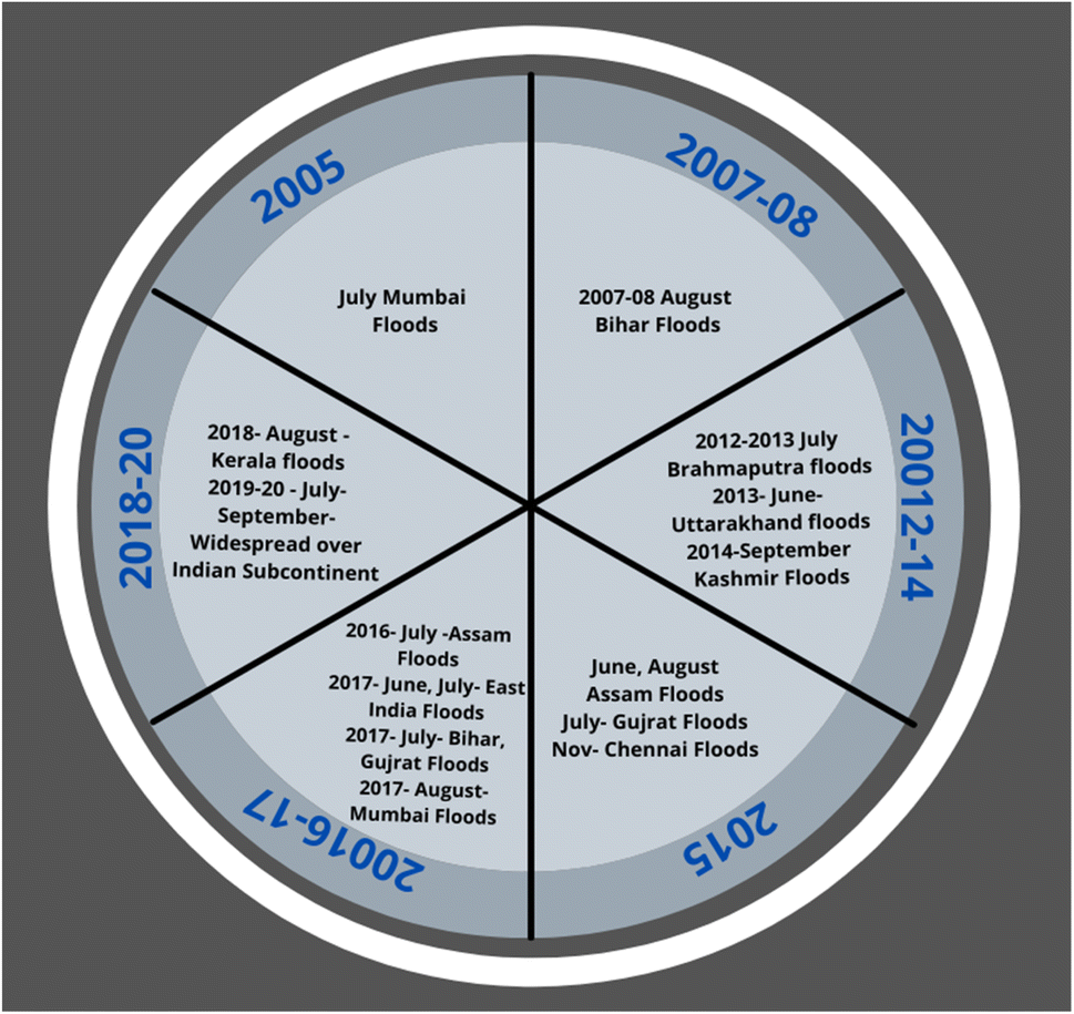 | ||
| Fig. 5 Timeline that shows the flood occurrence between 2005 and 2020. | ||
5.2. Extreme storms
Without a question, a thorough examination of the intricate ocean-atmosphere system has a significant impact on how well we comprehend how the world's climate is changing. For instance, it is now exceedingly difficult to anticipate tropical cyclones, which frequently lead to major environmental disasters.96 Tropical cyclones, which mostly occur over tropical oceans, frequently hit equatorial and near-equatorial parts of continents. Of course, after their creation, the cyclones do not always proceed eastward. Additionally, no coastal areas near the equator are impacted by cyclones.Despite the significant progress made in understanding numerous fluctuations in tropical cyclonic activity across the world, a clear picture of variations in tropical cyclones movement in the northern part of the Indian Ocean and severe rain events across the Indian subcontinent, remains elusive.97 Tropical cyclone trends documented between 1951 and 2019 (relative to the pre-1950s period) reveal a 49 percent rise in strong category tropical storms in the Bay of Bengal region and a 52 percent rise in the Arabian Sea region.98 The coasts being the prime receiver of such tropical cyclones and depressions are classified as high-risk areas and are thus prone to increased damage compared to the central zone. But the coasts also benefit due to their location as the accumulated water after the storms subside faster compared to the interiors, which helps in resuming the post-disaster remediation and other normal activities.
The yearly reported incidents of the North Indian Ocean's tropical cyclones have fallen by 23% every 10 years for the entire northern part of the Indian Ocean and 26% every 10 years for the Bay of Bengal. Observations made in the Indian Ocean suggest an increased frequency of very severe cyclonic storms, compared to normal storms, which is likely to be driven by the post-monsoon severe cyclonic storms trend (+0.86 every decade) arising from the Bay of Bengal.99 Another major cause of concern is the recent surge in the number and the power of tropical storms arising in the Arabian Sea region. Among them, 6 of 11 tropical storms created in the Arabian Sea between 2000 and 2018 were more severe.100
Storm surges created by severe cyclones are the most hazardous. High-speed winds are an immediate effect of any cyclones, sweeping across large areas of the ocean and coastal areas, resulting in a great number of deaths and widespread damage. The winds blowing, induce the ocean water collected, to build up on the land or coast, when they are surrounded by a shallow basin, resulting in abrupt inundation and flooding of coastal areas. The inundation of land by sea water is responsible for around 90% of the damage. Most of the lives lost and the majority of the damage and destruction caused by tropical storms are the result of the surges in storm conditions produced by the cyclones.101 The storms and cyclones are disastrous for the coastal zone, especially those that are in close proximity to the Indian Ocean. Different wetlands, lagoons, and mangrove forests are found along the coasts, that bear the first-hand impacts of storms and cyclones. The strong winds and pressure variations before storms disturb the natural habitat of the native species and post-storm flooding destroys the regions and causes erosion. Thus analyzing the patterns of storms, predicting their occurrences, and taking measures to minimize their destruction, would be beneficial for the transitional systems along the coastlines.
Reports have stated that even though the Bay of Bengal has a lower occurrence of tropical cyclones than the north-west Pacific, the regions that suffer the most in terms of deaths and property destruction, are the densely populated coastal areas in India, Bangladesh, and Myanmar.102 Odisha ranks first in terms of tropical cyclonic effect and the destruction caused every year, followed by Andhra Pradesh, West Bengal, and Tamil Nadu. In this basin, roughly five to six tropical cyclones emerge on average each year, with about three of them classified as severe cyclones.103 The recent storm Amphan that struck the eastern coast in the year 2020, resulted in nearly 14 billion dollars in losses for the entire country, in terms of both lives lost and property damage. Other cyclones such as Tauktae and Vayu hit the western coast and cyclones such as Fani, Nivar, Amphan, and Gaja have hit the eastern coastal regions in the past few years, and have resulted in similar large-scale losses. The lowlands all along these coasts, as well as other low-lying massive deltas like the Gangetic and Ayeyarwady deltas, are also the reason for massive damages caused in addition to the inability to precisely predict storm surges.104
Forecasting the intense dynamics in the ocean-atmosphere system takes a lot of work nowadays. However, predicting the progression of a tropical cyclone is a challenging task that involves predicting several variables, including strength, rainfall, and storm surge. Finding the source of a tropical storm is another, perhaps even more challenging challenge. With time and the aid of many information sources, including satellites, tropical cyclone forecasting techniques have altered. These technique's fundamental building blocks are the three primary categories of tropical cyclone forecast models: statistical, dynamical, and combined statistical-dynamic. These models simply determine pathways and intensities using meteorological data. It should be made clear that numerous dynamical and statistical-dynamical models have been created to predict the weather in general as well as cyclone paths and intensity in detail.105
Numerous researchers have carried out in-depth research on important topics, including structure, dynamics, and forecasting methods. There has been a lot of advancement in tropical cyclone prediction outside of the traditional approaches. Carvalho and Wang has put to use the novel technique of machine learning for forecasting tropical cyclone.106 Machine learning is developed from statistical techniques that may automatically identify pertinent rules for detection, analysis, prediction, etc. from enormous amounts of data. Several studies have shown that methods based on a purely data-driven approach and those that use machine learning to enhance numerical models both significantly improve cyclone predictions. There are still a lot of things that need to be studied, which we see as both an opportunity and a challenge. Existing research has made some progress in areas like genesis forecasts, path prediction, intensity prediction, cyclone weather prediction, and improving numerical forecast models by integrating machine learning.
5.3. Sea-level rise
As a result of climate change (global warming), ice and glacier melting has increased the average sea level all over the world. Sea-level rise has the potential to inflict unprecedented pressure on densely populated areas like coastal areas and low-lying regions across the world. The rise in sea levels has been reported by several researchers occurring across the globe, including in the Indian Ocean. The seas absorb over 90% of anthropogenic surplus heat, and with the melting of the arctic and Antarctic glaciers, more heat is absorbed by the ocean water causing sea level to rise at an alarming rate. This global warming has led to an average sea-level rise, across the globe, of 1.7 mm per year, since the 1900s, with the rising rate increasing to 3.3 mm per year since 1993.The important coastal ports in India along with the areas predicted to be impacted by the sea-level rise have been shown in Table 3. These areas are situated in proximity to the Oceanic water bodies surrounding India. Any variations in their water levels, especially in the Indian Ocean, will bring about several adverse effects. With various low-lying islands and coastal areas, as well as a broad spectrum of marine environments, the Indian Ocean region is rich in dense population and biodiversity. The uniqueness and richness of the ocean can be estimated from the humungous amount of species and endemic systems that thrive in and around the water bodies. These species contribute to both the diversity of the place and also have an economic and commercial value associated with them which is necessary to support the population of the Indian peninsula.
| Coasts | Coastal states in India | Main area of impact | Trend (mm per 100 year) by 2100 |
|---|---|---|---|
| a Ref. 107 and 108. | |||
| East coast | West Bengal | Kolkata | 830.316 |
| Diamond harbour | 582.58 | ||
| Haldia | 332.05 | ||
| Sager | −401.45 | ||
| Andhra Pradesh | Visakhapatnam | 53 | |
| West coast | Maharashtra | Mumbai | 77 |
| Gujarat | Kandla | 335 | |
| Karnataka | Mangalore | −148 | |
| South coast | Tamil Nadu | Chennai | 24 |
| Kerala | Cochin | 126 | |
A study determined that from the years 1874 to 2006, there had been a rise of 1.05–1.76 mm every year along the coastal lines of the Bay of Bengal and the Indian Ocean. From the years of 2004–2013, a study shows that north of the Indian Ocean (at 5 °C), there has been a basin-wide surge of 6 mm every year in the water level of the Indian Ocean. Recent reports have stated that the rise in sea level in the past 2 decades has exceeded the global sea level rise by nearly 2.5 mm per year. The Indian Ocean and the Pacific Ocean are the top 2 oceans that are demonstrating a rapid rise in sea levels. Both these oceans impact the Indian climate greatly. Another analysis known as the sea level budget analysis concluded that almost 70% of the rise in the Indian Ocean is due to thermostatic components present in the ocean, a term used to refer to the variations in the ocean created by alterations in levels of temperature or heat (Srinivasu et al., 2017).64 Along with the South-Eastern parts of the Indian Ocean, halosteric sea-level rise to about 6.41 ± 0.62 mm per year which following the thermostatic sea water level rise, is about 2–3 times that of the thermosteric sea water level rise of 3.712 ± 1.03 mm every year (Llovel and Lee, 2015).65
The areas near the Indian Ocean are habited with nearly 2.7 billion people, accounting for 40–45% of the world's population. As a result, rising sea levels may endanger 2 billion people, the economy, coastal property, and aquatic environments. Despite recent advances, significant gaps in understanding the reorientation of seawater levels and their originator remain, primarily at regional scales.111 The rise in seawater levels also hurts wetlands. The loss of the wetlands along the coasts will lead to the loss of biological richness, especially the endemic species, and reduce the productivity of the wetland systems. Sudden surges in the tidal levels in the local seas and rivers are also due to the rising sea levels. It is predicted that Indian cities like Mumbai, Kochi, Chennai, Visakhapatnam, Mangalore, and Thiruvananthapuram will bear heavy impacts of rising sea levels by 2050 and would have lost nearly 50% of their land area. The area and width of the wetlands of India are given in Table 4 along with the effect on them due to sea-level rise in Table 5.
| Coasts | State | Coastal length (km) | Wetland area (km2) | Width (km) |
|---|---|---|---|---|
| a Ref. 109 and 110. | ||||
| West coast | Gujarat | 1663 ± 1 | 25083 ± 2 | 15.08 ± 0.5 |
| Maharashtra & Goa | 720 ± 0.5 | 545 ± 1 | 0.76 ± 0.3 | |
| Karnataka | 290 ± 0.4 | 1800 ± 2 | 6.20 ± 1 | |
| South coast | Kerala | 560 ± 1 | 424 ± 0.5 | 0.76 ± 1 |
| Tamil Nadu & Puducherry | 1050 ± 0.08 | 3987 ± 3 | 3.8 ± 1 | |
| East coast | Andhra Pradesh | 930 ± 0.5 | 1855 ± 3 | 1.99 ± 0.8 |
| Orissa | 450 ± 0.8 | 1854 ± 2 | 4.12 ± 2 | |
| West Bengal | 200 ± 3 | 3604 ± 1 | 18.02 ± 0.3 | |
| Andaman & Nicobar | 348 Islands | 1078 ± 5 | NA | |
| Coasts | Coastal state | Projected rise in sea level (M) | Loss in wetland area (km2) |
|---|---|---|---|
| a Ref. 112 and 113. | |||
| West coast | Gujarat | 0.337 | 8452.972 |
| Maharashtra & Goa | 0.072 | 39.241 | |
| Karnataka | 0.256 | 460.801 | |
| South coast | Kerala | 0.125 | 53.000 |
| Tamil Nadu & Puducherry | 0.036 | 143.934 | |
| East coast | Andhra Pradesh | 0.052 | 96.468 |
| Odisha | 0.012 | 22.255 | |
| West Bengal | 0.582 | 2099.816 | |
| Total | 11368.463 | ||
The current rates of rising sea levels are a major concern due to the decrease in land area and destruction of properties and lives, especially for the coastal cities, in proximity to the seas, that house huge populations. Three huge national highways in India pass near the ocean. Therefore, sea-level rise may lead to the loss of existing roads and communication networks near the sea. The control of salinity, as well as the management of biological species and flood protection measures, should be a top priority for policymakers.
5.4. Indian ocean warming
Under a global warming scenario, it is anticipated that variations in air fluxes brought on by greenhouse gas emissions will accelerate warming. Unexpectedly, it is discovered that the net surface heat fluxes across the Indian Ocean region alone are insufficient to account for the ongoing warming. The substantial correlation between the sea surface height anomaly and the warm pool area anomaly in the Indian Ocean suggests that the ocean advection mechanisms have a significant impact on warming and expansion. Rao et al. showed that the net surface heat flow (advection) alone tends to cool (warm) the Ocean by utilizing heat budget analysis of different Ocean data assimilation products.82During the monsoon months (June–September), strong monsoon winds cause ocean surging, modifying evaporation patterns and moisture transfer. They also contribute significantly to CO2 emissions in the atmosphere and support high levels of marine primary production, which helps in the conversion of inorganic substrates to organic compounds, thereby serving as the basis for the food chain (Roxy et al. 2016).114 Among all the tropical oceans, the Indian Ocean is warming at the fastest rate, accounting for nearly 20% of ocean thermal content, estimated over the past 20–25 years. The Indian Ocean has nearly 30–35% of coral reefs and 13–15% of the world's fisheries. A surge or any rapid fluctuations in heat-transferring waves in the oceans are commonly called marine heat waves. These waves have a significant impact on the marine and coastal ecosystem, which includes corals and phytoplankton, as well as the fisheries. Furthermore, the formation of warm pools in the Indian Ocean affects sub-seasonal weather fluctuations in the surrounding areas, such as the intra-seasonal variation and the Madden–Julian variation. This affects rainfall patterns, particularly severe rains in the tropics, which primarily include all the coastal states of India.
As the regional and overall climatic patterns are linked to human-induced climate changes like heat waves, floods, tropical cyclones, storms, and augmented sea water-level alterations are becoming more frequent and powerful in the Indian Ocean. As a result, understanding the current climatic condition and possible progressions in the warming of the Indian Ocean, as well as its pivotal role in altering the local and global climate is very crucial. As a result, efforts to develop effective adaptation and preventative measures to mitigate the risk posed by climate change must rely on extensive and ongoing monitoring of shifting patterns, as well as the refinement of current climate models.
In many parts of the world, ocean warming will increase in frequency, duration, and intensity during the ensuing decades. This problem will take major work to solve. It will also require governance arrangements that support novel adaptation strategies, such as protecting refugia for foundation marine species of coral, kelp, and seagrass that serve as crucial habitats for marine ecosystems. This will go beyond just a coordinated global pledge to decrease emissions of greenhouse gases. The projections of ecosystem impacts call for a biological comprehension of species' thermal sensitivity and critical thresholds and how these relate to other stressors, even though accurate ocean warming prediction will necessitate enhanced process-based insight into ocean warming and its drivers. For the protection and sustainability of our maritime ecosystems and the services they offer, it will be necessary to coordinate mitigation and adaptation actions. This will call for innovative solutions that cross conventional disciplinary lines. In a warming world, techniques will need to be adaptive to keep up with changes in ocean warming, which will be made easier by skilful ocean warming prediction.
6. Synoptic scale systems
Scale systems characterize the weather conditions in the Indian subcontinent that comprises Monsoon depression, monsoon cyclones, western disturbances, etc. (classification according to the Indian Meteorological Department, IMD). These weather systems are the reason for snowstorms, floods, and other natural calamities that come to the Indian landmass. In the month of June to September, the weather scale system is usually of monsoon low-pressure systems. When the speed of the windfalls is below 8.75 m s−1, then the systems are categorized as low-pressure systems. The monsoon difference occurs when the speed of the wind is between 8.75 and 17 m s−1 whereas cyclonic storms occur when the speed of the wind is more than 17 m s−1. Most of the LPS occur in the Bay of Bengal and in the northwest areas of India where the speed of the wind is almost 1.4 to 2.8 m s−1. A few traces of the low-pressure systems can also be found in the Arabian Sea and the trough region of the Indian Peninsula. From December to April, while most of the Indian peninsula undergoes winter or early spring season, high precipitation during this time, in southern regions, is the result of the high-pressure conditions that are generated over the Indian Ocean, which in turn aid in the formation of moisture-laden clouds and fog in the early morning. The disturbances that cause these light or heavy precipitation are known as western disturbances or WDs. WDs occur usually in the Caspian, Black, or Mediterranean Sea which moves on the east side of North India. The mechanism of WDs occurs due to the interaction of warm humid air from the tropical regions and the cold dry air from the extra-tropical areas, regions beyond the tropics, commonly referred to as mid-latitudes. WDs are prevalent in the mid-latitude regions, between 30 and 60° north and south of the equator. In these regions, due to the interaction of the winds, a low-pressure system is generated which draws the winds inwards, allowing them to rotate in an anti-clockwise direction, creating a pathway for precipitation in the surrounding areas. WDs cause a lot of precipitation during the winter seasons in the northern part of India, the Himalayan ranges, and mount Kush ranges which can cause extreme flooding. Almost 30% of the annual average rainfall that occurs over the northern regions of India is contributed by the WDs.7. Transitional ecosystem
The next step following the discussion of climatic parameters and their subsequent effects is the definition of ecosystems and their importance. Restricting the study to only observing the visible changes in temperature, precipitation, ocean and sea levels, etc., will not provide a clear picture of their vitality. Discussing the multiple interlinked life cycles, nutrient balances, and in turn understanding how each of them is being affected by climate change completes the whole picture. Transitional ecosystems are also ecosystems, referred to in a more detailed manner. They are independent bodies that have endemic characteristics. The very name indicates that these systems do not have definite or limited lifeforms that follow a specific pattern of survival. In transitional systems, the physical conditions such as temperature, rainfall, regional water levels, and chemical conditions like the pH levels of water bodies, nutrient concentration in soil, etc., are ever-changing and its components are continuously evolving to adapt to the changes. All of these impact the biological conditions such as the growth, interaction, and development of the species dwelling in the systems. These conditions are vital when discussing transitional systems as they are a closed web containing sensitive endemic species. Even subtle variations alter the life cycles and can pose a threat to these valuable, yet sensitive life forms in the transitional ecosystems.They are similar to general ecosystems, such that they comprise both biotic and abiotic components, but the prime difference lies in the type of components. The entities that make up the transitional systems are endemic i.e., they are unique to the geographical location where they are found. They include estuaries, marshlands, lagoons, deltas, mangroves, and coastal lakes which exhibit complex human–environmental relationships and bear the impacts of climatic changes. Transitional ecosystems are different from the synoptic systems on basis of their scale of magnitude. The synoptic scale systems deal with relationships and interlinking among the biotic and abiotic factors on a scale that includes continents and oceans. They also include cyclones and depressions, global warming, and other factors affecting climate. They are a mixture of multiple transitional ecosystems. Studies are currently being undertaken to identify factors governing these ecosystems and the variations in their operation compared to the mainland. India has 14 large-sized, 44 medium-sized, and 162 minor estuaries and riverine systems, the major ones being the Bay of Bengal on the eastern coast and Mandovi and Zuari on the western coast. Each ecosystem requires sub-division and separate study as their characteristics depict remarkable variation within themselves. These ecosystems form an ecotone (transitional zone) and are among the top populated zones with abundant species, especially aquatic animals. They have little disturbances from external agents and the estuaries and lagoons are remodeled by native species, thereby allowing minimal wave action from the seas and oceans. The salinity in these locations favours the growth of multiple species that store and recycle nutrients, allowing the capture of sediments. Table 6 unveils the prime ecosystems in India and their speciality.
| Name of ecosystem | Location | Cities | Species | Specialty |
|---|---|---|---|---|
| a Ref. 114–118. | ||||
| Mangroves | East and west coast | West Bengal, Orissa, Gujarat | River dolphins, turtles, tigers, otters | Marshy land with tides is essential for pH and sediment control. Beneficial for the growth of aquatic life |
| Central plains | Central areas and the eastern coastline | Punjab, Delhi, Uttar Pradesh, Bihar, West Bengal, Assam | Asiatic lion, languor, fox, snakes | Rich fertile zones for cultivation and flooded lands are good for sediment accumulation |
| Deserts | Central states | Rajasthan and Gujarat | Chinkara, rats, mongoose, scorpion, red fox | Dry regions supporting climatic control and crop cultivation. Known to be the largest wool-producing region in India |
| Backwaters | Southern coastline | Kerala, Tamil Nadu, Karnataka, | River dolphins, turtles, tigers, otters, snakes | Exclusive regions for crop cultivation, fishing, and water sports, and vital for tourism |
| Coral Islands | Southern coastline | Andaman and Nicobar island, Lakshadweep | Saltwater crocodiles, snakes, dolphins, wire and soft corals, turtles | Essential for maintaining biodiversity and species balance. Major tourist attraction |
Different studies have been carried out to understand the process of development of these systems. These systems are restricted with minimal components that are needed for survival. Domenici et al.,5 2020 stated how these ecological entities lack heterogeneity among them in their embryo stages. This was elaborated highlighted the importance of disturbances and the establishment of dynamic equilibrium. These studies were able to determine how imbalances affect the systems. When there is any change within the endemic ecology like slow growth or excess of vegetation or over-consumption of any species, that would threaten the survival of another, the transitional ecosystems then interact with surrounding systems and merge to form a larger interactive entity. As the systems continue to grow and interact, their diversity increases and this heterogeneity plays a vital role in maintaining nutritional and aesthetic balance.
The first stage of studying the transitional systems involves the categorization of the ecosystems into matrices to limit the output services or interaction, of these ecosystems with the adjacent coastal environments. These matrices allow the classification and identification of the ecosystems and may provide scope for sub-categorization. These matrices deal with individual systems which are referred to as guilds and each matrix comprises 2–3 biological guilds which specialize in their endemic vegetation and animal life. Plenty of variations can be observed in the characteristics of the vegetation, flora, fauna, and constitution of the coastal water bodies, which are mainly influenced by differences in the salinity levels, acidity, turbidity, seawater interference and influence, sloping banks, and parameters governing habitat diversity. Certain ecosystems have been observed to have contributed to reducing sediment suspension and reducing erosion of the river or sea bed, favouring clear water and CO2 sequestration.
Estuaries and coastal lagoons exhibit vast diversity in species numbers and composition, e.g. about 5–6 species of macrophytes and only 8 or 9 species of fishes are common to 50% of the lagoons, and only 7–9 species of fishes are found in 50% of estuaries. These macrophytes can be used as indicators of good water quality, thereby playing a key role in setting up ecological status for study. Studies that have been conducted on such natives of these ecosystems were effective in linking their distant family species. Scientists have been able to study the various migrations and re-location of the sub-species before they finally ended up in their current locations. They have come up with results that show the similarities between the coastal and transitional ecosystems across the world and have stated that these systems hold similar characteristics, much greater than the ecosystems found in the interior landmass. A similar study conducted in Mumbai city of India shed light upon the macro-Benthos community thriving in the marine waters along the Arabian sea coast, their ability in filtering phytoplankton and in turn serve as a food source for larger fish which is part of the human food chain.
The factors influencing the characteristics of these transitional ecosystems include turbidity of the water, its sea/ocean currents, the direction of flow, different patterns followed throughout the year, pH of water, salinity, oxygen, and other elemental composition of the soil, and features of landmass surrounding the systems. All these parameters determine the life forms that can dwell in the systems. Special emphasis has been given to transitional ecosystems due to their vitality and multiple other ecosystems are dependent on them. Apart from human beings, these ecosystems are also the bearers of the ill effects associated with climate change. When discussing issues like temperature and precipitation changes, the topic of transitional ecosystems is unavoidable. Just like human beings are affected by rising temperatures and heat waves due to global warming, the endemic species dwelling in these rich zones are similarly affected. The changes result in nutrient depletion, leading to the death of plants and animals. Also, scarcity of nutrients and food in one system forces the species to migrate into another system for their survival, which results in the loss of richness and originality of the ecosystem. The originality and purity of the species, the richness of the landscapes, the nutrient content of the location, and so on, are lost. For example, the Ganga delta opening up into the Bay of Bengal on the eastern coast of Indian contains rich plant and animal diversity and is regarded as a unique transitional ecosystem. The endemic mangrove species found here play a vital role in sustaining and supporting life and nutrient cycles and preserving the richness and fertility of the soil. The mangrove roots are also responsible for minimizing the rapid and strong forces of the tidal currents, allowing settling of nutrients and this allows organisms to thrive in the waters.
Variations in the pH levels or changes in the ionic and elemental composition of the water that is in immediate contact with the mangrove roots will alter osmosis. This will alter the water and nutrient uptake by plants, affecting their growth, and eventually affecting the entire delta ecosystem. Due to the increase in population and growth of multiple villages and tourist spots in and around the Sundarbans, there has been a significant increase in human-induced pollution and waste generation, all of which accumulated in the river water. This condition has been further aggravated by reduced rainfall and flooding in the past few years. These conditions prevented the normal functioning of the mangrove roots, disabling them from maintaining nutrient and pH balance, which in turn led to the death of species in the river water and other birds and animals that are directly or indirectly dependent on them. The climatic and human factors also reduced the mangrove cover, which served as a natural habitat for endemic species like the Royal Bengal tiger. With their habitat being lost, these carnivores were compelled to venture into the human territories in search of food and shelter, which in turn disrupted the delicate balance between man and the wild. Several such encounters have been recorded in multiple locations globally, which highlights the necessity of preserving these systems without interference.
Fig. 6 shows an example of a self-sustainable transitional ecosystem along salty deltas. The relationship between different members of the ecosystem, their dependency on each other, and how each one of them contributes to the nutrient cycle, have been elaborated. Both the biotic components like plants and animals, and the abiotic components like air, water, soil, sunlight, and so on coexist for the maintenance of balance.
 | ||
| Fig. 6 Self-sustainable transitional eco-system along salty deltas. | ||
Previous studies have taken initiatives to understand the process of development of transitional ecosystems but have not elaborated on the multiple factors that influence them. Explanations of how variations in each parameter will affect ecological growth is scarce. However, due to the increased urbanization and industrialization, the effluent wastes washing up into the rivers interfere with the natural functioning of the ecosystem, which is considered highly detrimental. Understanding and categorizing the morphological, hydrological, and anthropogenic factors and disturbances affecting the ecosystems, evaluating their risk, and implementing remedial measures are essential for preserving the diversity of these ecosystems.
8. Policies to control climate change – current policies and their requirements
Climate change has become a prominent topic of discussion in national and international politics and diplomacy in recent decades. Through multiple periodic assessment reports, the IPCC (Intergovernmental Panel on Climate Change) provides holistic recommendations to international communities. Almost every country in the world in current times recognizes that fighting and controlling climate change is critical to sustainable and long-term human development. Preventing and mitigating the effects of climate change and global warming remains the biggest collective challenge for future human survival and habitability of planet earth irrespective of the country we live in. India, China, and the United States are the major emitters of greenhouse gases (GHGs) and thus have significant roles in setting the path for controlled uses and sustainable practices. The Government of India (GOI) has also revised policies and upgraded the Ministry of Environment, Forests, and Climate Change (MoEFCC). It is also encouraging the implementation of green technology in multiple sectors, financing eco-friendly ideas, and helping sustainable growth.Initially, India lacked the resources for contributing toward technology in mitigating global warming effects, despite being one of the largest emitters of GHGs. India's inability to combat climate change issues were not well received across the globe. However, it is to be pointed out that unlike first-world countries like the USA, UK, and Germany, India had to prioritize its immediate and long-term needs due to a lack of financial resources and overpopulation. In India controlling widespread poverty, over-population, and satisfying energy demand for the population at an affordable cost was considered the immediate target. To satisfy the ever-increasing demand for affordable energy as the population increases, India embraced fossil fuels like coal (power generation) and petrol/diesel (transportation) which are damaging to the environment. The lack of affordable and sufficient renewable energy resources (except hydroelectric projects which are present all over the country) has restricted the government from making radical energy reforms that are capable of mitigating global warming effects.
However, in the recent past three decades, the general population has become environmentally conscious and organizations along with the skilled mindset of policymakers, India was able to participate in several international agreements and is now an active member of the global community fighting against climate change. Montreal protocol implementation in 1987 was the beginning of India's policy development. The Intergovernmental Negotiating Committee (INC) conducted several meetings between February 1991 and May 1992 for the development of policies and suggested the usage of ‘per capita equity’ for reducing GHGs emissions. India, in recent years, has observed economic growth and has obtained equal footing with China and US in terms of its ability to tackle climatic changes and work for its betterment. India is now cooperating with other countries for climate change negotiations and policies as compared to its prior position in the G77 coalition in the 1900s. It is also an active member of the Paris agreement since 2016 and is contributing to the reduction of global warming by ratification of nearly 4% of GHGs. In the recent UN Climate Change Conference (CoP26), held in Glasgow, Scotland (2021), for the development and implementation of sustainable development goals, India played an active role, pledging to achieve net-zero carbon emission by the year 2070 and has also proposed policies and ideas for renewable energy usage and reduce carbon usage.
In 1991, the Ministry of Environment and Forests (MoEF) adopted the Environmental Protection Act of 1986 in the Indian Coastal Regulation Zone (CRZ). To safeguard vulnerable and fragile ecosystems, CRZ guidelines ban activities such as construction, mining, clearance of forests, landfilling, and near-coastal industrial activity. They limit activities that could endanger fragile coastal ecosystems.119 Within stipulated distances from the coastline, constructional, industrial, and disposal activities are prohibited according to CRZ-I which focuses on the implementation of the Environmental Protection Act in 1986. The division of coastal areas into 4 parts allows for better classification and implementation of rules for conservation.120
• CRZ-I for ecologically sensitive areas near the sea.
• CRZ-II for the developed urban coastal areas.
• CRZ-III for underdeveloped rural semi-urban coastal areas.
• CRZ-IV for underdeveloped rural or urban coastal areas with limited permission.
CRZ-1 protects areas important for biodiversity and ecology like Mangroves, coral and sea reefs, wildlife sanctuaries, natural reserves, and breeding grounds with aesthetic, ecological, and historical significance and prohibits all constructional activities within 500 m distance from high tide areas. CRZ-II operates for municipal boundaries and infrastructures like roadways, water supplies, sanitation, and drainage and covers both developed and developing areas. Indian island territories are covered in CRZ IV. Coastal areas of the Andaman and Nicobar Islands, Lakshadweep, and neighbouring islands fall under CRZ-IV.
Integrated Coastal Zone Management (ICZM) was established in 2011 for ensuring the proper implementation of CRZ by a bottom-up approach. CRZ-III deals with the areas that do not fall under CRZI or II. CRZ-III also prohibits construction activities near coasts but allows these areas to be used as recreational spots such as parks, gardens, pastures, etc., ensuring the preservation of both land and green cover, at the same time, enhancing the aesthetic value of the areas. The latest activities from the MoEFCC include the inspection of all coastal projects and strict action on illegal and unauthorized developments. All these measures are taken, irrespective of their scale and complexity. They are vital and effective measures for bringing about a change and conserving the coastal regions which form the support systems for millions of Indians who reside in them.121
9. Adaptation measures for sustainable coastal ecosystems
Coastal areas of India are one of the biggest hot spots in which development activities can take place. Coastal wetlands in India account for almost 27% of the total wetland area of nearly 15.5 million hectares.122 The coastal wetlands have been given minimal attention and have been studied far less which has brought in many remote variations in the methodological inconsistencies of the wetlands.123Most of the protection of wetlands is done through conservative measures in India through the act of protected areas (PA). However, most PA's measures have proven to be ineffective in terms of prevention of degradation within the wetlands mainly due to poor infrastructure, lack of human and financial resources as well as political will. Many of the protected areas lack long-term ecological goals as well as aims to evaluate how effective the management is carried out.124 All wetlands fall under the classification of marine and coastal protected areas, including coastal areas and also national parks, and sanctuaries reserves under the Wildlife Protection Act of 1972. There are significant or separate rules and regulations to protect wetlands.125 Some drives help in reducing the degradation such as the drive to prevent Timber extraction from Mangrove trees which are above 40 percent in the Indian coastal lines, water extraction, extraction of edible supplies, and so on.126–128 Apart from the drive, India has also tried to restore the degraded coastal areas since 1980. However, the drawback of these restoration facilities is that the efforts are usually specific to a certain plantation without considering the total ecosystem of the wetlands, their conditions, and their ecological habitats.129 Most projects taken up in India have been falling short of desired success rates in attaining restoration.
The Indian Government has passed laws on wetlands conservation, restoration, and management and restrained activities that interfere with these ecosystems. Wetlands were classified into sensitive ecological areas put in category CRZ I. These rules were first passed in 2010 and then amended in 2017 and 2018 to keep pace with the recent advancement in lifestyles and national developments.130 Human activities have hampered several areas, including mangroves that are exposed to harsh conditions due to changes in the neighbouring regions.131 These activities affect and alter the mangrove's inherent properties to resist rising sea levels and almost 70% of them are considered to be endangered. Further conversion of wetlands is resulting in permanent losses and biological damages.132,133 These are more pronounced as there are interconnections between coastal wetlands and surrounding habitats. The preservation of these habitats and the re-development of lost land can be achieved by ecosystem-based management (EBM), which employs site-specific and species-specific data.134 EBM aims to achieve conservation, sustainable usage, and equitable distribution of natural resources which will allow a balance between short-term requirements and long-term sustainability.135
International organizations like United Nations have set up policies for the current decade to ensure environmental restoration (2021–2030) and several countries across the globe are joining in for the betterment of all. However, it is essential to understand and focus on the ultimate goal, which would help in setting down effective guidelines.136,137 There have been cases where organizations have focused on the immediate expansion of areas, relocation of species, demolition of infrastructure, and unplanned expansion for conservation, but have failed to look into the larger effects of such activities.138 Construction of facilities along the coastlines itself holds the risk of coastal erosion. Further unplanned activities like their demolition are sure to bring about multiple detrimental effects. It is thus necessary to spread awareness at the initial stage among all the stakeholders and then proceed with the activities on a larger scale. It is essential that inter-linking among different species, their role in the current ecosystems, the possibility of replacement, risk of new species introductions, and effects of anthropogenic interventions, are taken into account, which would help in the creation and sustenance of healthy eco-systems.139
The major impact of climate change are identified in water, agriculture, forests, health, energy and infrastructure sectors of India.140 The higher cost of adaptation technologies, limited knowledge on adaptation measures and lack of improved technology are the major challenges in adapting the climate change measures. Lack of awareness and the non-availability of timely information and dissemination of information on early warnings of climate change to the public is one of the biggest challenge in India.141 Non-availability of resilient crop varieties, limited incentives to adopt soil and water conservation practices, inadequate support system to diversify income from agriculture, limited access to credit and markets are the key challenges faced by Indian agricultural sector.142
To reduce the impact of climate change, many Indian states have developed heat action plans, cities are installing cool roofs, and increasing their green cover. Limiting global warming to 1.5 °C instead of 2 °C could result in around 420 million people exposed to extreme heat waves and related health effects (NRDC, 2022). If the adaptation measures are not implemented, the majority of the vulnerable population of India will face the adversities of climate change due to low capabilities, weak institutional mechanisms and lack of access to adequate resources”.143 India needs a significantly larger investment to achieve the climate resilience and adaptation. The adaptation gaps exist between current levels of adaptation and levels needed to respond should be reduced to reduce the impacts (NRDC, 2022).
10. Conclusion
The study expands on multiple research and findings that have been carried out over the past years as the IPCC and MOES reports. Special reports on the climate and policies like the Coastal Regulation Acts, their benefits, and how they have been able to protect nearly 10–12% of the coastal lands. Topics like transitional ecosystems and their sensitivity, which are of great importance in the current day, were not explored to great extents previously.• A sustainable mitigation and adaptation strategy must be developed right now given the current condition of the climate emergency. It is crucial to make clear that there is no one best way to combat climate change, and that all of the technologies and strategies covered in this analysis should be used if they are technically and financially feasible. However, it will take time for the technologies to be implemented to be created, evaluated, and appropriately account for any negative effects.
• The different factors responsible for climate change should be monitored. Each zone, based on its location receives variable effects and thus the areas which are more prone to climatic ill-effects like the low-lying areas, coastal regions, transitional ecosystems, hilly regions with loose topsoil, and agricultural lands should be given utmost importance.
• The development of policies for climate change control helps in prioritizing the actions needed for reducing the dangers, which helps countries to come together for a collective action plan to be taken. International pacts and organizations have also stepped forward to take collective actions on a worldwide scale. It is thus essential to understand that climatic change is not a localized phenomenon and only collective, well-planned and calculative actions with a pragmatic outlook would help in mitigating the ill effects, all of which would contribute to creating a sustainable, comfortable life for the present and future generations.
Although climate change necessitates the urgent attention of human civilization, it is also shrouded in ambiguity since models cannot predict what will occur and when it will occur, or to whom. Regarding how to deal with regional and global change, there are countless theories, methods, and viewpoints that are all founded on various perspectives on how to know and be in the world as well as various aspirations for the future. The ability to catalogue and comprehend the efficacy of distinct adaptation mechanisms aids in incorporating this change into informed, better-planned efforts, and more advantageous adaptation results.
Abbreviation
| CCCR | Centre for Climate Change Research |
| CFCs | Chlorofluorocarbons |
| CMIP | Common Management Information Protocol |
| CNN | Cloud Condensation Nuclei |
| DU | Dobson unit |
| G77 | Group of 77 |
| GCM | General Circulation Model |
| GHGs | Green House Gases |
| GOI | Government of India |
| GWP | Global Warming Potential |
| IMD | Indian Meteorological Department |
| INC | Intergovernmental Negotiating Committee |
| INCCA | Indian Network for Climate Change Assessment |
| IPCC | Intergovernmental Panel on Climate Change |
| ISRO | Indian Space Research Organization |
| LPS | Low Pressure System |
| MK | Mann Kendall |
| MMCFS | Monsoon Mission Coupled Forecasting System |
| MMK | Modified Mann Kendall |
| MoEFCC | Ministry of Environment, Forest and Climate Change |
| MOES | Ministry of Earth Sciences |
| NCP | National Carbon Project |
| NIO | National Institute of Oceanography |
| NMF | National Maritime Foundation |
| PPM | Parts per Million |
| PRL | Physical Research Laboratory |
| RCP | Representative Concentration Pathway |
| RF | Radiative Forcing |
| SPI | Standardized Precipitation Index |
| SPIE | Society of Photo-Optical Instrumentation Engineers |
| UNFCCC | United Nations Framework Convention on Climate Change |
| WD | Western Disturbances |
| WRF | Weather Research and Forecasting |
Conflicts of interest
There are no conflicts to declare by the authors.References
- K. Raghavan, J. Sanjay, C. Gnanaseelan, M. Mujumdar, A. Kulkarni and S. Chakraborty, Assessment of Climate Change over the Indian Region A Report of the Ministry of Earth Sciences (MoES), Government of India: A Report of the Ministry of Earth Sciences (MoES), Government of India, 2020 Search PubMed.
- T. Raab, J. Krümmelbein, A. Schneider, W. Gerwin, T. Maurer and M. A. Naeth, Phys. Geogr., 2012, 33, 305–343 CrossRef.
- S. Irmak, I. Kabenge, K. E. Skaggs and D. Mutiibwa, J. Hydrol., 2012, 420–421, 228–244 CrossRef.
- V. Pratap, S. Tiwari, A. Kumar and A. K. Singh, J. Earth Syst. Sci., 2021, 130, 230 CrossRef CAS.
- P. Domenici and F. Seebacher, The impact of climate change on bio mechanics of animals, Conserv. Physiol., 2020, 8, coz102 CrossRef.
- A. M. van Valkengoed and L. Steg, Nat. Clim. Change, 2019, 9, 158–163 CrossRef.
- R. S. Wilson, A. Herziger, M. Hamilton and J. S. Brooks, Nat. Clim. Change, 2020, 10, 200–208 CrossRef.
- C. Singh, T. Deshpande and R. Basu, Reg. Environ. Change, 2017, 17, 527–538 CrossRef.
- A. Q. Dar, H. Maqbool and S. Raazia, MATEC Web Conf., 2016, 57 Search PubMed.
- T. Das, M. H. D. Majumdar, R. K. T. Devi and T. Rajesh, SAARC J. Agric., 2016, 14, 200–209 CrossRef.
- T.-H. Joung, S.-G. Kang, J.-K. Lee and J. Ahn, J. int. marit. saf., 2020, 4, 1–7 Search PubMed.
- K. Singh, C. Byun and F. Bux, Ecol. Eng., 2022, 182, 106708 CrossRef.
- S. Javadinejad, R. Dara and F. Jafary, Saf. Extreme Environ., 2020, 2, 189–195 CrossRef.
- P. L. Zarnetske, J. Gurevitch, J. Franklin, P. M. Groffman, C. S. Harrison, J. J. Hellmann, F. M. Hoffman, S. Kothari, A. Robock and S. Tilmes, Proc. Natl. Acad. Sci., 2021, 118, e1921854118 CrossRef CAS PubMed.
- R. Patil and M. Deo, J. Waterw. Port, Coast., 2020, 146, 04020002 CrossRef.
- D. Kalyan, A. I. Pathan, P. G. Agnihotri, M. Y. Azimi, D. Frozan, J. Sebastian, U. Mohseni, D. Patel and C. Prieto, ICO, 2022, 371, 685–694 Search PubMed.
- K. Ansari, Mar. Geophys. Res., 2022, 43, 6 CrossRef.
- K. Kantamaneni, S. Panneer and A. Krishnan, et al., Arabian J. Geosci., 2022, 15, 814 CrossRef.
- G. Sreenivasulu, N. Jayaraju, B. C. S. R. Reddy, T. L. Prasad, K. Nagalakshmi and B. Lakshmanna, GeoResJ, 2017, 13, 38–48 CrossRef.
- A. Sundaramanickam, N. Shanmugam, S. Cholan, S. Kumaresan, P. Madeswaran and T. Balasubramanian, Environ. Pollut., 2016, 218, 186–195 CrossRef CAS PubMed.
- K. James, K. Vasant, S. M. Sikkander Batcha, S. Padua, R. Jeyabaskaran, S. Thirumalaiselvan, G. Vineetha and L. V. Benjamin, Reg. Stud. Mar. Sci., 2021, 41, 101558 Search PubMed.
- H. B. Bhatt, S. D. Gohel and S. P. Singh, 3 Biotech, 2018, 8, 1–12 CrossRef PubMed.
- V. Ayyam, S. Palanivel and S. Chandrakasan, Coastal ecosystems of the Tropics-adaptive management, Springer, 2019 Search PubMed.
- V. Ramaswamy, P. M. Muraleedharan and C. P. Babu, Sci. Rep., 2017, 7, 13676 CrossRef CAS.
- K. Saha, P. Sanyal and S. Saha, Estuarine, Coastal Shelf Sci., 2022, 278, 108096 CrossRef CAS.
- K. Banerjee, S. Sappal, P. Ramachandran and R. Ramachandran, J. Clim. Change, 2017, 3, 59–72 Search PubMed.
- S. Bal, S. Saha, B. Fand, N. Singh, J. Rane and P. Minhas, Hailstorms: Causes, Damage and Post-hail Management in Agriculture, 2014 Search PubMed.
- E. Oliver, M. Burrows, M. Donat, A. Gupta, L. Alexander, S. Perkins-Kirkpatrick, J. Benthuysen, A. Hobday, N. Holbrook, P. Moore, M. Thomsen, T. Wernberg and D. Smale, Front. Mar. Sci., 2019, 6, 734 CrossRef.
- T. L. Frölicher, E. M. Fischer and N. Gruber, Nature, 2018, 560, 360–364 CrossRef.
- M. G. Jacox, M. A. Alexander, S. Siedlecki, K. Chen, Y.-O. Kwon, S. Brodie, I. Ortiz, D. Tommasi, M. J. Widlansky, D. Barrie, A. Capotondi, W. Cheng, E. Di Lorenzo, C. Edwards, J. Fiechter, P. Fratantoni, E. L. Hazen, A. J. Hermann, A. Kumar, A. J. Miller, D. Pirhalla, M. Pozo Buil, S. Ray, S. C. Sheridan, A. Subramanian, P. Thompson, L. Thorne, H. Annamalai, K. Aydin, S. J. Bograd, R. B. Griffis, K. Kearney, H. Kim, A. Mariotti, M. Merrifield and R. Rykaczewski, Prog. Oceanogr., 2020, 183, 102307 CrossRef.
- A. Panda, Retrieved from Migration Policy Institute: https://www.migrationpolicy.org/article/climate-change-displacement-managed-retreat-india, 2020.
- Q. He and B. R. Silliman, Curr. Biol., 2019, 29, R1021–R1035 CrossRef CAS PubMed.
- S. Siddha and P. Sahu, in Ecological Significance of River Ecosystems, ed. S. Madhav, S. Kanhaiya, A. Srivastav, V. Singh and P. Singh, Elsevier, 2022, pp. 79–104, DOI:10.1016/B978-0-323-85045-2.00014-5.
- P. R. Shukla, J. Skea, E. Calvo Buendia, V. Masson-Delmotte, H. O. Pörtner, D. C. Roberts, P. Zhai, R. Slade, S. Connors and R. Van Diemen, Climate Change and Land: an IPCC special report on climate change, desertification, land degradation, sustainable land management, food security, and greenhouse gas fluxes in terrestrial ecosystems, IPCC, 2019 Search PubMed.
- V. V. S. S. Sarma, M. S. Krishna, Y. S. Paul and V. S. N. Murty, Tellus B, 2015, 67, 24638 CrossRef CAS.
- T. S. Ramachandran, S. M. Vinod, S. Murugan Sreedevi, S. Gunasekaran, T. Perumal, R. Chinnadurai and K. Rajendran, J. Indian Chem. Soc., 2022, 99, 100681 CrossRef CAS.
- P. K. Singh and R. C. Dhiman, J. Vector Borne Dis., 2012, 49, 55 Search PubMed.
- F. Lehner, C. Deser and B. M. Sanderson, Clim. Change, 2018, 146, 363–375 CrossRef.
- J. Sanjay, J. V. Revadekar, M. V. S. Ramarao, H. Borgaonkar, S. Sengupta, D. R. Kothawale, J. Patel, R. Mahesh, S. Ingle, K. AchutaRao, A. K. Srivastava and J. V. Ratnam, in Assessment of Climate Change over the Indian Region: A Report of the Ministry of Earth Sciences (MoES), Government of India, ed. R. Krishnan, J. Sanjay, C. Gnanaseelan, M. Mujumdar, A. Kulkarni and S. Chakraborty, Springer Singapore, Singapore, 2020, pp. 21–45, DOI:10.1007/978-981-15-4327-2_2.
- C. Zhao, B. Liu, S. Piao, X. Wang, D. B. Lobell, Y. Huang, M. Huang, Y. Yao, S. Bassu and P. Ciais, Proc. Natl. Acad. Sci., 2017, 114, 9326–9331 CrossRef CAS PubMed.
- V. Kumar and S. Jain, Hydrol. Res., 2011, 42, 290 CrossRef.
- A. K. Taxak, A. R. Murumkar and D. S. Arya, Weather Clim. Extrem., 2014, 4, 50–61 CrossRef.
- C. Kavitha, P. Vijayasarathi, P. Tamizhdurai, R. Mythily and V. L. Mangesh, S. Afr. J. Chem. Eng., 2022, 42, 270–279 Search PubMed.
- R. Noska and V. Misra, Geophys. Res. Lett., 2016, 43, 4547–4554 CrossRef.
- R. Cavicchioli, W. J. Ripple, K. N. Timmis, F. Azam, L. R. Bakken, M. Baylis, M. J. Behrenfeld, A. Boetius, P. W. Boyd, A. T. Classen, T. W. Crowther, R. Danovaro, C. M. Foreman, J. Huisman, D. A. Hutchins, J. K. Jansson, D. M. Karl, B. Koskella, D. B. Mark Welch, J. B. H. Martiny, M. A. Moran, V. J. Orphan, D. S. Reay, J. V. Remais, V. I. Rich, B. K. Singh, L. Y. Stein, F. J. Stewart, M. B. Sullivan, M. J. H. van Oppen, S. C. Weaver, E. A. Webb and N. S. Webster, Nat. Rev. Microbiol., 2019, 17, 569–586 CrossRef CAS.
- W. Chen, B. Dong, L. Wilcox, F. Luo, N. Dunstone and E. J. Highwood, J. Clim., 2019, 32, 7539–7560 CrossRef.
- P. Sharma, V. Abrol, S. Abrol and R. Kumar, Resource Management for Sustainable Agriculture, 2012, 75, pp. 139–164 Search PubMed.
- S. A. Montzka, E. J. Dlugokencky and J. H. Butler, Nature, 2011, 476, 43–50 CrossRef CAS PubMed.
- W. Nordhaus, Clim. Change, 2018, 148, 623–640 CrossRef.
- M. Goyal and R. Surampalli, J. Environ. Eng., 2018, 144(7) CrossRef CAS.
- X. Sun, K. Wang, S. Kang, J. Guo, G. Zhang, J. Huang, Z. Cong, S. Sun and Q. Zhang, Environ. Pollut., 2017, 220, 936–945 CrossRef CAS PubMed.
- A. R. Carrasco, Front. Ecol. Evol., 2019, 7, 77 CrossRef.
- A. Pérez-Ruzafa, C. Marcos, I. M. Pérez-Ruzafa and M. Pérez-Marcos, J. Coast. Conserv., 2011, 15, 369–392 CrossRef.
- A. Sfriso, M. Mistri, C. Munari, A. Buosi and A. Sfriso, Front. Ecol. Evol., 2020, 8, 20 CrossRef.
- S. Veerasingam, P. Vethamony, R. Mani Murali and B. Fernandes, Mar. Pollut. Bull., 2015, 91, 362–367 CrossRef CAS PubMed.
- G. Azhar, PLoS One, 2014, 9(3), e91831 CrossRef PubMed.
- C. Gao, K. Kuklane, P.-O. Östergren and T. Kjellstrom, Int. J. Biometeorol., 2018, 62, 359–371 CrossRef.
- M. Karmakar and M. M. Pradhan, Nat. Hazards, 2020, 102, 659–671 CrossRef.
- N. Dhingra, P. Jha, V. Sharma, A. Cohen, R. Jotkar, P. Rodriguez, D. Bassani, R. Laxminarayan and R. Peto, Lancet, 2010, 376, 1768–1774 CrossRef PubMed.
- P. Pawar and A. R. Al Tawaha, Adv. Environ. Biol., 2017, 11, 1–1122 CAS.
- A. K. Ranjan, A. K. Patra and A. K. Gorai, Sci. Total Environ., 2020, 745, 141024 CrossRef CAS PubMed.
- M. Seenirajan, M. Natarajan, R. Thangaraj and M. Bagyaraj, J. Geogr. Inf. Syst., 2017, 2017, 126–140 Search PubMed.
- A. Akilan, S. Balaji, K. K. Abdul Azeez and M. Satyanarayanan, J. Geol. Soc. India, 2017, 90, 602–608 CrossRef.
- U. Srinivasu, M. Ravichandran, W. Han, S. Sivareddy, H. Rahman, Y. Li and S. Nayak, Clim. Dyn., 2017, 49, 3887–3904 CrossRef.
- W. Llovel and T. Lee, Geophys. Res. Lett., 2015, 42(4), 1148–1157 CrossRef.
- M. Benke, J. Takle, D. S. Pai and S. A. Rao, J. Earth Syst. Sci., 2019, 128, 182 CrossRef.
- R. Ojha, D. N. Kumar, A. Sharma and R. Mehrotra, J. Hydrol. Eng., 2013, 18, 760–772 CrossRef.
- D. S. Bisht, V. Sridhar, A. Mishra, C. Chatterjee and N. S. Raghuwanshi, Int. J. Climatol., 2019, 39, 1889–1911 CrossRef.
- S. Satheesh, S. Babu, B. Padmakumari, G. Pandithurai and V. Soni, Variability of atmospheric aerosols over India, in Observed climate variability and change over the Indian region, 2017, pp. 221–248 Search PubMed.
- A. M. Arangio, J. H. Slade, T. Berkemeier, U. Pöschl, D. A. Knopf and M. Shiraiwa, J. Phys. Chem. A, 2015, 119, 4533–4544 CrossRef CAS PubMed.
- P. Sadavarte and C. Venkataraman, Atmos. Environ., 2014, 99, 353–364 CrossRef CAS.
- A. Pandey, P. Sadavarte, A. B. Rao and C. Venkataraman, Atmos. Environ., 2014, 99, 341–352 CrossRef CAS.
- R. Krishnan, T. P. Sabin, R. Vellore, M. Mujumdar, J. Sanjay, B. N. Goswami, F. Hourdin, J. L. Dufresne and P. Terray, Clim. Dyn., 2016, 47, 1007–1027 CrossRef.
- S. Undorf, D. Polson, M. Bollasina, Y. Ming, A. Schurer and G. Hegerl, J. Geophys. Res.: Atmos., 2018, 123(10), 4871–4889 CrossRef CAS.
- V. Vinoj, P. J. Rasch, H. Wang, J.-H. Yoon, P.-L. Ma, K. Landu and B. Singh, Nat. Geosci., 2014, 7, 308–313 CrossRef CAS.
- C. G. Gertler, S. P. Puppala, A. Panday, D. Stumm and J. Shea, Atmos. Environ., 2016, 125, 404–417 CrossRef CAS.
- W. K. M. Lau, C. Yuan and Z. Li, Sci. Rep., 2018, 8, 3960 CrossRef PubMed.
- A. S. Mahajan, I. De Smedt, M. S. Biswas, S. Ghude, S. Fadnavis, C. Roy and M. van Roozendael, Atmos. Environ., 2015, 116, 194–201 CrossRef CAS.
- T. Schneider, T. Bischoff and G. H. Haug, Nature, 2014, 513, 45–53 CrossRef CAS PubMed.
- B. Zambri, A. LeGrande, A. Robock and J. Slawinska, J. Geophys. Res.: Atmos., 2017, 122(15), 7971–7989 CrossRef PubMed.
- G. Berz, W. Kron, T. Loster, E. Rauch, J. Schimetschek, J. Schmieder, A. Siebert, A. Smolka and A. Wirtz, Nat. Hazards, 2001, 23, 443–465 CrossRef.
- S. A. Rao, A. R. Dhakate, S. K. Saha, S. Mahapatra, H. S. Chaudhari, S. Pokhrel and S. K. Sahu, Clim. Change, 2012, 110, 709–719 CrossRef.
- R. K. Vellore, R. Krishnan, J. Pendharkar, A. D. Choudhury and T. P. Sabin, Clim. Dyn., 2014, 43, 2009–2031 CrossRef.
- J. Liu and D. Niyogi, Sci. Rep., 2019, 9, 7301 CrossRef PubMed.
- M. Masood, P. Yeh, N. Hanasaki and K. Takeuchi, Hydrol. Earth Syst. Sci., 2015, 19, 747–770 CrossRef.
- R. Ajayamohan, W. Merryfield and V. Kharin, J. Clim., 2010, 23, 1004–1013 CrossRef.
- J. V. Revadekar, H. Varikoden, B. Preethi and M. Mujumdar, Nat. Hazards, 2016, 81, 1611–1625 CrossRef.
- R. K. Madhura, R. Krishnan, J. V. Revadekar, M. Mujumdar and B. N. Goswami, Clim. Dyn., 2015, 44, 1157–1168 CrossRef.
- K. Hunt, J. Curio, A. Turner and R. Schiemann, Geophys. Res. Lett., 2018, 45(16), 8629–8636 CrossRef.
- K. M. R. Hunt, A. G. Turner and L. C. Shaffrey, Q. J. R. Metereol. Soc., 2018, 144, 278–290 CrossRef.
- A. P. Dimri, D. Niyogi, A. Barros, J. Ridley, U. C. Mohanty, T. Yasunari and D. Sikka, Rev. Geophys., 2015, 53(2), 225–246 CrossRef.
- F. Cannon, L. M. V. Carvalho, C. Jones and B. Bookhagen, Clim. Dyn., 2015, 44, 441–455 CrossRef.
- N. Bassi, M. D. Kumar, A. Sharma and P. Pardha-Saradhi, J. Hydrol. Reg. Stud., 2014, 2, 1–19 CrossRef.
- S. C. Gairola, Indian For., 2014, 140, 113–128 Search PubMed.
- K. D. Rode, E. Peacock, M. Taylor, I. Stirling, E. W. Born, K. L. Laidre and Ø. Wiig, A tale of two polar bear populations: ice habitat, harvest, and body condition, Popul. Ecol., 2012, 54, 3–18 CrossRef.
- R. Rajagopalan, Governance and institutional issues, Food and Agriculture Organization of the United Nations, 2011, pp. 33–49 Search PubMed.
- T. Worthington, P. Bunting, N. Cormier, A. Donnison, L. Fatoyinbo, D. Friess, T. Hengl, L. Hilarides, K. Krauss, D. Lagomasino, P. Leinenkugel, K. Longley-Wood, C. Lovelock, R. Lucas, N. Murray, S. Narayan, W. Sutherland, P. zu Ermgassen and M. Spalding, Mangrove restoration potential: A global map highlighting a critical opportunity, 2019 Search PubMed.
- R. Krishnan, T. P. Sabin, R. K. Madhura, R. K. Vellore, M. Mujumdar, J. Sanjay, S. Nayak and M. Rajeevan, Clim. Dyn., 2019, 52, 4091–4109 CrossRef.
- K. M. R. Hunt and A. Menon, Clim. Dyn., 2020, 54, 2433–2446 CrossRef.
- K. J. E. Walsh, J. L. McBride, P. J. Klotzbach, S. Balachandran, S. J. Camargo, G. Holland, T. R. Knutson, J. P. Kossin and T. Lee, Wiley Interdiscip. Rev. Clim. Change, 2016, 7, 65–89 CrossRef.
- T. Knutson, S. J. Camargo, J. C. L. Chan, K. Emanuel, C.-H. Ho, J. Kossin, M. Mohapatra, M. Satoh, M. Sugi and K. Walsh, Bull. Am. Meteorol. Soc., 2019, 100, 1987–2007 Search PubMed.
- T. Prowse, A. Bring, J. Mard and E. Carmack, Arctic freshwater synthesis: Introduction, J. Geophys. Res.: Biogeosci., 2015, 120, 2121–2131 CrossRef.
- M. Mohapatra, B. K. Bandyopadhyay and A. Tyagi, in Monitoring and Prediction of Tropical Cyclones in the Indian Ocean and Climate Change, ed. U. C. Mohanty, M. Mohapatra, O. P. Singh, B. K. Bandyopadhyay and L. S. Rathore, Springer Netherlands, Dordrecht, 2014, pp. 3–17, DOI:10.1007/978-94-007-7720-0_1.
- M. Mohapatra, B. K. Bandyopadhyay and L. S. Rathore, Tropical cyclone activity over the North Indian Ocean, Springer, 2017 Search PubMed.
- N. Deshpande, D. Kothawale, V. Kumar and J. Kulkarni, Int. J. Climatol., 2018, 38(11), 4172–4188 CrossRef.
- K. S. Carvalho and S. Wang, J. Hydrol., 2019, 569, 373–386 CrossRef.
- J. Church, D. Monselesan, J. Gregory and B. Marzeion, Environ. Res. Lett., 2013, 8, 014051 CrossRef.
- J. Hansen, M. Sato, P. Kharecha and K. Von Schuckmann, Atmos. Chem. Phys., 2011, 11, 13421–13449 CrossRef CAS.
- J. Church, N. White, L. Konikow, C. Domingues, J. Cogley, E. Rignot, J. Gregory, M. Van den Broeke, A. Monaghan and I. Velicogna, Geophys. Res. Lett., 2013, 40, 4066 CrossRef.
- U. Alakkat, N. Gangadharan and M. Lengaigne, Curr. Sci., 2015, 108, 966–971 Search PubMed.
- K. E. Trenberth, J. T. Fasullo and M. A. Balmaseda, J. Clim., 2014, 27, 3129–3144 CrossRef.
- T. Izumo, C. B. Montégut, J.-J. Luo, S. K. Behera, S. Masson and T. Yamagata, J. Clim., 2008, 21, 5603–5623 CrossRef.
- V. Valsala and R. Murtugudde, Deep Sea Res., Part I, 2015, 103, 101–113 CrossRef CAS.
- M. K. Roxy, A. Modi, R. Murtugudde, V. Valsala, S. Panickal, S. Prasanna Kumar, M. Ravichandran, M. Vichi and M. Lévy, Geophys. Res. Lett., 2016, 43, 826–833 CrossRef.
- L. M. Beal, J. Vialard and M. K. Roxy, CLIVAR-4/2019, GOOS 237, 206.
- C. T. Sabeerali, S. A. Rao, G. George, D. N. Rao, S. Mahapatra, A. Kulkarni and R. Murtugudde, J. Geophys. Res.: Atmos., 2014, 119, 5185–5203 CrossRef.
- M. K. Roxy, P. Dasgupta, M. J. McPhaden, T. Suematsu, C. Zhang and D. Kim, Nature, 2019, 575, 647–651 CrossRef CAS PubMed.
- A. Tripathi and A. K. Mishra, Clim. Risk Manag., 2017, 16, 195–207 CrossRef.
- A. Mahato, Int. J. Sci. Res. Publ., 2014, 4, 1–6 Search PubMed.
- S. Solomon, D. Qin, M. Manning, Z. Chen, M. Marquis, K. B. Averyt, M. Tignor and H. L. Miller, Climate change 2007: Synthesis Report. Contribution of Working Group I, II and III to the Fourth Assessment Report of the Intergovernmental Panel on Climate Change, Summary for Policymakers, 2007 Search PubMed.
- C. Dasgupta, in Handbook of Climate Change and India, Routledge, 2012, pp. 113–122 Search PubMed.
- R. Saryal, South Asia Res., 2018, 38, 1–19 CrossRef.
- S. K. Dube, I. Jain, A. D. Rao and T. S. Murty, Nat. Hazards, 2009, 51, 3–27 CrossRef.
- C. Shaji, S. K. Kar and T. Vishal, Int. J. Mol. Sci., 2014, 43, 125–137 Search PubMed.
- B. Sahoo and P. K. Bhaskaran, Int. J. Climatol., 2018, 38, 403–419 CrossRef.
- J. K. Panigrahi and P. K. Mohanty, Ocean Coast. Manag., 2012, 65, 34–50 CrossRef.
- R. R. Krishnamurthy, R. DasGupta, R. Chatterjee and R. Shaw, J. Coast. Conserv., 2014, 18, 657–672 CrossRef.
- T. Spencer, M. Schuerch, R. J. Nicholls, J. Hinkel, D. Lincke, A. T. Vafeidis, R. Reef, L. McFadden and S. Brown, Glob. Planet. Change, 2016, 139, 15–30 CrossRef.
- N. J. Murray, S. R. Phinn, M. DeWitt, R. Ferrari, R. Johnston, M. B. Lyons, N. Clinton, D. Thau and R. A. Fuller, Nature, 2019, 565, 222–225 CrossRef CAS PubMed.
- K. Kathiresan, Curr. Sci., 2018, 976–981 CrossRef.
- Q. Lin and S. Yu, Sci. Rep., 2018, 8, 1–10 Search PubMed.
- H. K. Lotze, H. S. Lenihan, B. J. Bourque, R. H. Bradbury, R. G. Cooke, M. C. Kay, S. M. Kidwell, M. X. Kirby, C. H. Peterson and J. B. C. Jackson, Science, 2006, 312, 1806–1809 CrossRef CAS PubMed.
- C. M. Crain, B. S. Halpern, M. W. Beck and C. V. Kappel, Ann. N. Y. Acad. Sci., 2009, 1162, 39–62 CrossRef PubMed.
- J. H. Cowan Jr, J. C. Rice, C. J. Walters, R. Hilborn, T. E. Essington, J. W. Day Jr and K. M. Boswell, Mar. Coastal Fish., 2012, 4, 496–510 CrossRef.
- V. F. Krapivin, V. Y. Soldatov, C. A. Varotsos and A. P. Cracknell, J. Atmos. Sol.-Terr. Phys., 2012, 89, 83–89 CrossRef.
- H. L. Stern and K. L. Laidre, Sea-ice indicators of polar bear habitat, Cryosphere, 2016, 10, 2027–2041 CrossRef.
- K. W. Krauss and M. J. Osland, Ann. Bot., 2020, 125, 213–234 Search PubMed.
- A. Chunera, D. Dash and A. Deep, J. Pharmacogn. Phytochem., 2019, 8, 1685–1690 Search PubMed.
- M. C. S. Bantilan, N. P. Singh, K. Byjesh, R. Padmaja and W. Jayatilaka, International Crops Research Institute for the Semi-Arid Tropics, Policy Brief, 2013, vol. 23 Search PubMed.
- I. Gjertz and C. Lydersen, Polar bear predation on ringed seals in the fast-ice of Hornsund, Svalbard, Polar Res., 1986, 4, 65–68 CrossRef.
- R. Kumar, Policy Department Economic and Scientific Policy. TERI-Europe, London, 2008 Search PubMed.
- L. Jin, P. G. Whitehead, S. Sarkar, R. Sinha, M. N. Futter, D. Butterfield, J. Caesar and J. Crossman, Environ. Sci.: Processes Impacts, 2015, 17, 1098–1110 RSC.
- P. G. Whitehead, E. Barbour, M. N. Futter, S. Sarkar, H. Rodda, J. Caesar, D. Butterfield, L. Jin, R. Sinha and R. Nicholls, Environ. Sci.: Processes Impacts, 2015, 17, 1057–1069 RSC.
| This journal is © The Royal Society of Chemistry 2023 |