
 Open Access Article
 This Open Access Article is licensed under a
 Creative Commons Attribution 3.0 Unported Licence
Evolution of India's PM2.5 pollution between 1998 and 2020 using global reanalysis fields coupled with satellite observations and fuel consumption patterns†
Sarath
Guttikunda
 *ab and
Nishadh
KA
b
*ab and
Nishadh
KA
b
aTRIP-Centre, Indian Institute of Technology, New Delhi, India. E-mail: sguttikunda@urbanemissions.info
bUrban Emissions, New Delhi, India
First published on 27th September 2022
Abstract
General practice is to rely on ambient monitoring data for reporting and regulatory applications in air quality management. Based on data collated for 2021, Delhi ranked the most polluted capital city, and another 62 Indian cities are in the top 100 most polluted cities list (https://www.iqair.com). This path limits the scrutiny and evaluation only to the cities with a monitoring station, neglecting a large section of non-urban areas. In this paper, we present a summary of evolution of PM2.5 pollution in India between 1998 and 2020, using reanalysed ground-level PM2.5 concentrations estimated by combining satellite AOD retrievals with chemical transport model results from a GEOS-Chem-CEDS system, and subsequently calibrated to on-ground observations. Between 1998 and 2020, India's annual average PM2.5 values steadily increased across the country, Delhi remained the most polluted state in all the years, and total population complying with the annual ambient standard of 40 μg m−3 dropped from 60.5% to 28.4%. According to the GBD-MAPS program, 81% of PM2.5 pollution in India is sourced to fuel (coal, petrol, diesel, gas, biomass, and waste) combustion that supports daily activities in the fields of personal transport, freight transport, electricity generation, industrial manufacturing, cooking, heating, construction, road dust resuspension, and waste burning. We overlayed the pollution trend with fuel consumption and activity patterns to further explain this evolution. While the 2 month COVID-19 lockdown period in 2020 provides evidence to argue that the only way to achieve “clean air” is by (a) cutting emissions at all the sources and (b) cutting emissions regionally, some hard decisions are required to enable and sustain larger reductions across sectors to reach not only the national ambient standard, but also the WHO guideline of 5 μg m−3.
Environmental significanceAccess to long-term air pollution data and knowing the origins of pollution are pivotal for air quality management in any country. General practice is to rely on ambient monitoring data for reporting and regulatory applications. However, this path limits the scrutiny and evaluation only to the cities with a monitoring station, neglecting a large section of non-urban areas. Indian cities and rural areas are among the most polluted in the world and the lack of monitoring data is limiting the policy makers' ability to fill the gaps on (a) how much is the pollution and (b) where is the pollution. Global reanalysis databases combining satellite feeds and chemical transport models provide a large backdrop to understand the growing air pollution problem in India, allowing us to identify the missing hotspots and authenticate the pollution loads at the source level. |
1 Introduction
Access to long-term air pollution data is pivotal to understand the spatial and temporal evolution of the problem in any country. In air quality management, general practice is to rely on monitoring data for regulatory related decision making. In 2019, India's Ministry of Environment Forests and Climate Change (MoEFCC) announced the National Clean Air Programme (NCAP).1 Under the programme, 132 non-attainment cities (i.e., cities that did not meet the annual ambient standard in 2017) were asked to prepare action plans to reduce their ambient PM2.5 pollution levels by 20–30% by 2024, compared to the pollution levels recorded in 2017. This path limits the scrutiny and evaluation only to the cities with a monitoring station.As of February 2022, there are 340 continuous ambient monitoring stations in India covering 174 cities. Of these, 148 cities operate only 1 station, which can only be used for guidance and cannot be used as a representative sample to study trends or base policy discussions on. However, this is 400% improvement on September 2017 numbers, when only 74 stations were operational in 43 cities. Delhi is the most spatially represented city with 40 stations, followed by Mumbai (21) as the only cities with more than 20 operational stations. This count is still less than the recommended number of at least 77 and 65 stations in Delhi and Mumbai, respectively, according to thumb rules established by the Central Pollution Control Board (CPCB).2 India's monitor density of 0.25 per million population is not a representative sample for regulatory and research grade pollution analysis.3,4 This density factor is the lowest among the big countries – China (1.2), the USA (3.4), Japan (0.5), Brazil (1.8) and most European countries (2–3). While the limited monitoring data are useful in building trends, studying compliance, and raising public awareness, a large portion of the country is neglected by focusing only on urban areas with monitors.5
On the other hand, we have the atmospheric modelling community, combining a larger pool of data from multiple resources including satellite retrievals and bottom-up emission inventories coupled with chemical transport models, helping us build patterns in emissions, pollution, and activity data, all in the hope of plugging the gaps in ambient and emission monitoring data.6–12 This path is data intensive and computationally challenging, and requires substantial personnel training to move forward from planning to execution. The applications of these systems have multiplied since the availability of satellite databases from NASA and ESA's open access portals and through analytical software like Google Earth Engine, which allows the user to analyse the data without downloading. Ref. 7 presented a version of community emissions data system (CEDS), which collates existing best-available global and regional emission inventories in a model-ready format. Besides the widely used global inventories like EDGAR13,14 and GAINS-ECLIPSE,15 the new system also includes regional inventories from China,16 East-Asia,17 India,18 Nepal,19,20 and Africa,21 making the inventories relevant for regional chemical transport modelling applications. Ref. 10 and 11 present an inverse modelling technique using TROPOMI's NO2 columnar observations to estimate emission loads for a city airshed and large point sources like coal-fired power plants. For known locations, this method can be used to crosscheck past inventories or even authenticate the reported stack emission rates. Ref. 12 developed algorithms to estimate PM2.5 concentrations at 1 km resolution using a combination of MODIS-AOD, MERRA2 reanalysis AOD, and ground measurements for 20 years. While there is a lot of technical and personnel capacity building to take shape on ambient and emissions monitoring, these global databases provide a large backdrop to understand the growing air pollution problem in India, allowing us to identify the missing hotspots and authenticate the pollution loads at the source level.
While the kind of information gathered from monitoring and modelling exercises is different in shapes and sizes, both are integral pillars of an air quality management campaign. In this paper, we present a summary of evolution of PM2.5 pollution in India between 1998 and 2020 using global reanalysis fields, coupled with discussion on trends in fuel consumption and activity patterns.
2 Data
PM2.5 concentration data and source contribution estimates are extracted from 2 open-access databases established by researchers and scientists in the Atmospheric Composition Analysis Group, the Washington University in St. Louis (WUSTL), USA. Ref. 8 estimated ground-level PM2.5 concentrations as annual and monthly averages, for the period of 1998–2020 by combining AOD retrievals from the NASA's MODIS, MISR, and SeaWIFS instruments with the GEOS-Chem global chemical transport model coupled with the gridded CEDS global emission inventory, and subsequently calibrated to on-ground observations. The Global Burden of Disease – Mapping of Air Pollution Sources (GBD-MAPS)6 used the same modelling system to establish source contribution fractions for a representative year 2017 and extended to 2019 under business-as-usual conditions. 20 source categories defined under GBD-MAPS were aggregated into 10 broader source categories for the ease of general consumption and discussion (Table 1). The uncertainty analysis and comparative analysis between the model results and available measurements across the global are included in ref. 8 and 22 and all the emission and model databases are available as a public repository @ https://sites.wustl.edu/acag/datasets/gbd-maps.| Source definition | Source code (used in this paper) | GBD-MAPS codes | Modeled %range as state averages | |
|---|---|---|---|---|
| 1 | Anthropogenic dust | Dust | AFCID | 7.5–17.7 |
| 2 | Wind erosion (dust storms) | Windust | WDUST | 1.1–9.4 |
| 3 | Waste burning | Waste | WST | 3.0–6.8 |
| 4 | All commercial and residential cooking, lighting, and heating | Resi | RCOC + RCOO + RCORbiofuel + RCORcoal + RCORother | 19.0–40.0 |
| 5 | All transport (excluding aviation) | Trans | ROAD + NRTR + SHP | 4.8–11.8 |
| 6 | Energy generation | Power | ENEcoal + ENEother | 7.1–21.8 |
| 7 | All industries and product use | Indus | INDcoal + INDother + SLV | 10.5–19.7 |
| 8 | Biomass burning, including forest fires and agricultural waste burning | Biob | GFEDoburn + GFEDagburn | 0.0–12.8 |
| 9 | Agricultural activities (excluding agricultural waste burning) | AGR | AGR | 2.5–12.5 |
| 10 | All others | Other | Other | 3.1–11.7 |
All the reanalysis and source contribution data are available at 0.01° resolution (∼1 km). These data were aggregated to 640 districts and 36 states and union territories, as per the 2011 census. The states include Telangana from the bifurcation of Andhra Pradesh in 2014. The state of Jammu & Kashmir (as per the 2011 census) includes the new union territories – Jammu & Kashmir and Ladakh. For convenience, data for years 1998, 2000, 2005, 2010, 2015, and 2020 only are presented in the figures and tables. All the extracted data by state and by district for all years are included in the ESI.†.
Annual gridded population data between 2000 and 2019 are obtained from the Oakridge National Labs LANDSCAN program.23 Several resources for sectoral energy and emission discussion were accessed from their respective annual reports and open-access databases presented in the ESI.†
3 Observations and discussion
3.1 Modelled annual averages
Between 1998 and 2020, India's annual average PM2.5 values steadily increased across the country (Fig. 1). On India's air quality index (AQI) scales, pollution levels over the Indo-Gangetic Plain (IGP) moved from poor to very poor and severe conditions and those over the Central India region moved from moderate to poor conditions. At the administrative level, the number of districts complying with India's annual ambient standard of 40 μg m−3 dropped from 440 to 255 (out of 640) and the number of states dropped from 29 to 21 (out of 36, including union territories).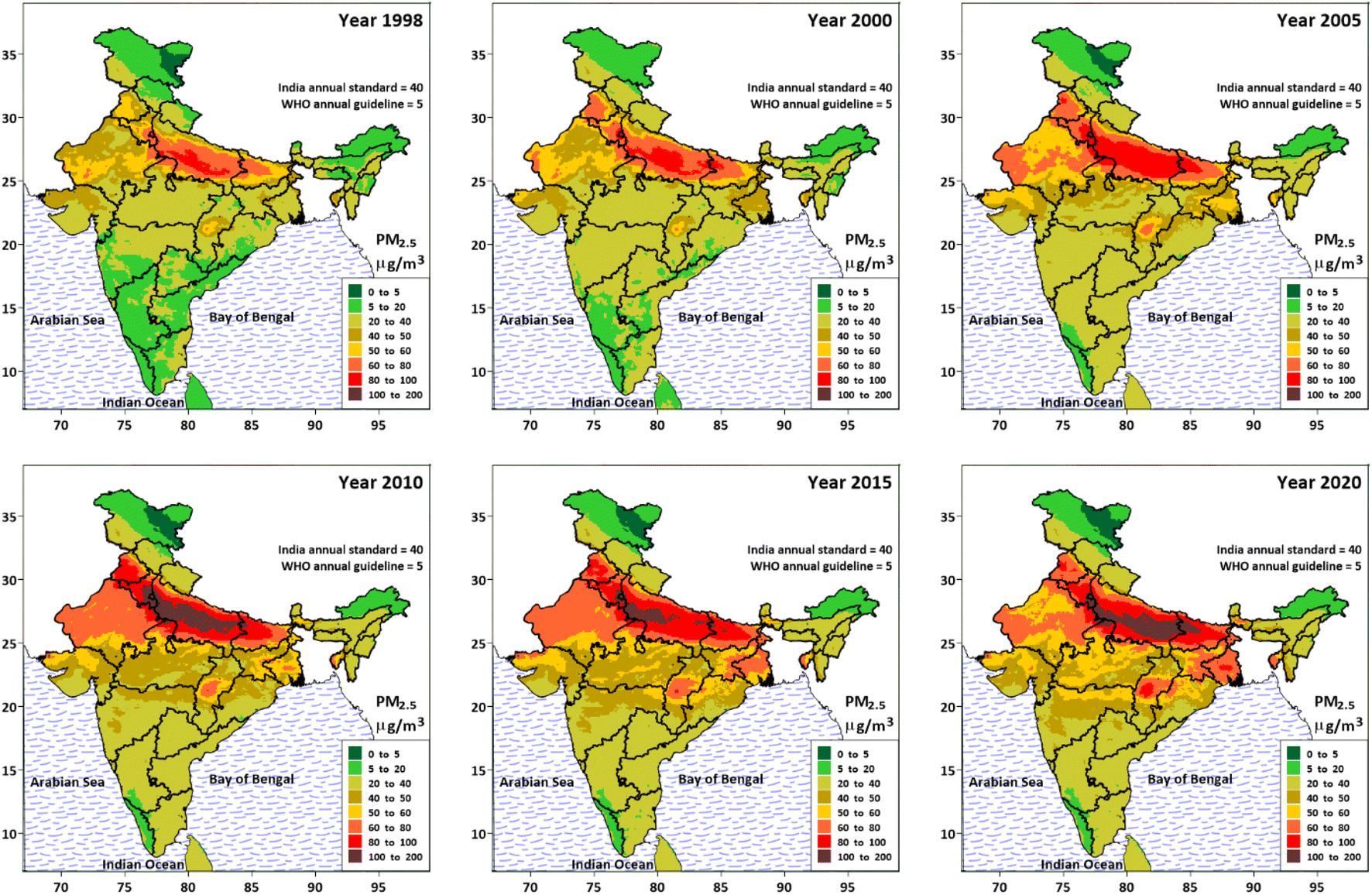 | ||
| Fig. 1 Modelled PM2.5 concentrations for India. Data source.8 | ||
Gridded concentrations at 0.1° (∼10 km) are overlapped with gridded population at the same resolution, to estimate the fractions of population exposed to various pollution bins (Fig. 2). In these 23 years, total population complying with the annual ambient standard (green-shade bars) dropped from 60.5% to 28.4%, with most of this change coming from non-urban areas in the IGP. The biggest change in %exposed is on the lower concentration side – 5–20 μg m−3, which is synonymous to background concentrations. In 2020, only a small portion of India's population lived in areas complying with the World Health Organization (WHO)'s new guideline of 5 μg m−3. In the same period, the population exposed to poor, very poor, and severe AQI levels (red-shade bars) increased from 0.0% to 17.8%, which is an indication of urban areas spreading their emission footprints. Traditionally, these increases are observed over cities and now visible over rural areas. According to the 2011 census, 2774 rural settlements were reclassified as urban settlements, pushing the total to 3894. This number is expected to cross 6000 in the new census. There are at least 51 cities with more than 1 million inhabitants and the urban population is expected to grow from 30% to 50% by 2050.
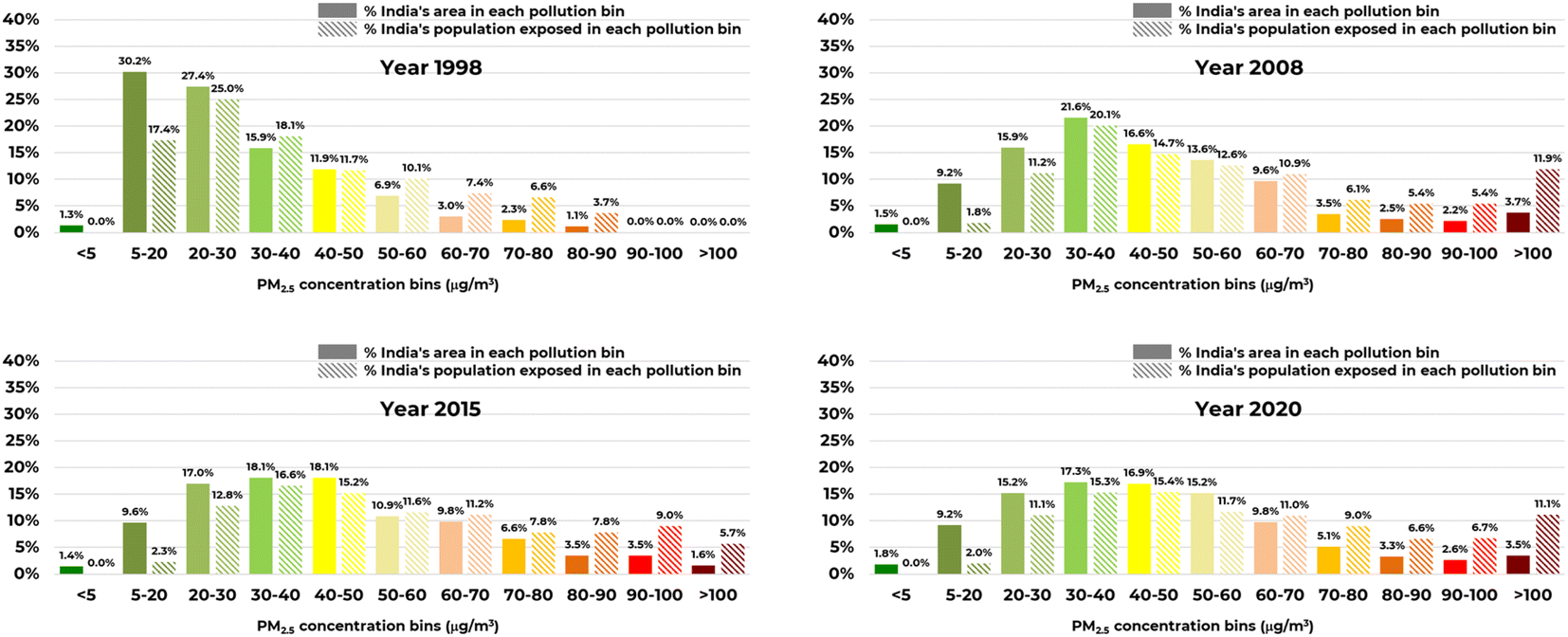 | ||
| Fig. 2 Estimated population and land area percentages exposed to various PM2.5 pollution bins. | ||
An increase in the population exposed is also reflected in the estimated number of premature deaths linked to air pollution, despite improvements in health care access. According to GBD estimates, total premature deaths due to outdoor PM2.5 exposure levels increased from 380![[thin space (1/6-em)]](https://www.rsc.org/images/entities/char_2009.gif) 000 in 2000 to 1.0 million in 2019 and because household PM2.5 (HAP) from solid fuels decreased from 1.0 million in 2000 to 600000 in 2019. The highest burden is reported from IGP states.24 The gradual decrease in HAP related exposures is due to an increase in programs promoting clean fuels like LPG and electricity for cooking, kitchen ventilation, and improved cookstoves.25 On average, 24%, 21%, 22%, 21%, 30%, 16%, and 11% of total premature deaths due to lower respiratory infections (LRIs), lung cancer, ischemic health disease, ischemic stroke, cardio obstructive pulmonary disease (COPD), diabetes, and neonatal outcomes, respectively, were associated with outdoor PM2.5 pollution exposure in 2019.26
000 in 2000 to 1.0 million in 2019 and because household PM2.5 (HAP) from solid fuels decreased from 1.0 million in 2000 to 600000 in 2019. The highest burden is reported from IGP states.24 The gradual decrease in HAP related exposures is due to an increase in programs promoting clean fuels like LPG and electricity for cooking, kitchen ventilation, and improved cookstoves.25 On average, 24%, 21%, 22%, 21%, 30%, 16%, and 11% of total premature deaths due to lower respiratory infections (LRIs), lung cancer, ischemic health disease, ischemic stroke, cardio obstructive pulmonary disease (COPD), diabetes, and neonatal outcomes, respectively, were associated with outdoor PM2.5 pollution exposure in 2019.26
At the state level, Delhi remained the most polluted state for all the years (1998–2020). A summary of state average concentrations and ranks among the 36 states and union territories is presented in Table 2 (36 being the least polluted and 1 being the most polluted). The most polluted states are from the landlocked IGP – Punjab, Haryana, Delhi, Uttar Pradesh, Bihar, and West Bengal, together hosting 400+ million people. Telangana and Andhra Pradesh moved 6 spots up on the most polluted list from 24 to 18 and from 30 to 24, respectively. Maharashtra with 18 non-attainment cities under the NCAP (the most) moved from 19 to 15. Puducherry (coastal, union territory) is the most improved and moved from 22 to 29. Overall, annual average PM2.5 concentrations worsened in all the states. Between 1998 and 2020, Jharkhand, Maharashtra, Odisha, and West Bengal's averages increased 80–90% – these are also the states which experienced an increase in the capacity and number of coal-fired thermal power plants.27,28 The most polluted state, Delhi, increased 40% from 80 μg m−3 to 111 μg m−3. An improvement between 2010 and 2020 is primarily due to the introduction of newer fuel and vehicle standards, promotion of piped liquified natural gas (LPG), expansion of LPG connections, and completion of Western and Eastern freight corridors. On average, PM2.5 pollution levels in Northern, IGP, Western, Northeast, Central-East, and Southern India and Union Territories increased 28%, 53%, 32%, 46%, 79%, 64%, and 42% respectively.
| Region/State name | 1998 | 2000 | 2005 | 2010 | 2015 | 2020 | |
|---|---|---|---|---|---|---|---|
| North India | |||||||
| 1 | Jammu & Kashmir | 13.5 (32) | 17.5 (32) | 15.1 (33) | 16.3 (33) | 16.2 (33) | 15.3 (34) |
| 2 | Himachal Pradesh | 18.6 (28) | 25.9 (20) | 23.4 (31) | 25.5 (30) | 27.2 (26) | 26.1 (28) |
| 3 | Uttarakhand | 23.4 (16) | 31.6 (14) | 28.3 (21) | 31.8 (17) | 34.9 (17) | 31.0 (22) |
| Indo-Gangetic Plain | |||||||
| 4 | Bihar | 54.6 (3) | 60.4 (4) | 66.4 (4) | 75.2 (5) | 78.2 (4) | 83.9 (3) |
| 5 | Haryana | 53.8 (4) | 62.9 (3) | 72.6 (3) | 90.2 (2) | 84.2 (3) | 83.3 (4) |
| 6 | Delhi | 80.0 (1) | 90.8 (1) | 101.1 (1) | 126.9 (1) | 112.1 (1) | 111.3 (1) |
| 7 | Punjab | 47.3 (5) | 57.7 (5) | 63.8 (5) | 76.3 (4) | 73.7 (5) | 70.9 (5) |
| 8 | Uttar Pradesh | 63.0 (2) | 68.2 (2) | 77.7 (2) | 88.6 (3) | 85.3 (2) | 88.2 (2) |
| 9 | West Bengal | 36.3 (8) | 42.2 (8) | 48.4 (8) | 53.1 (8) | 59.4 (8) | 66.0 (6) |
|
|||||||
| Western India | |||||||
| 10 | Gujarat | 35.0 (9) | 36.5 (10) | 41.4 (12) | 42.3 (13) | 44.2 (14) | 45.5 (13) |
| 11 | Rajasthan | 45.7 (6) | 48.7 (6) | 57.4 (6) | 63.9 (6) | 65.4 (6) | 61.2 (8) |
|
|||||||
| Northeast India | |||||||
| 12 | Arunachal Pradesh | 8.5 (35) | 10.6 (35) | 13.6 (35) | 13.0 (35) | 12.4 (35) | 12.2 (35) |
| 13 | Assam | 19.5 (26) | 23.4 (23) | 27.7 (22) | 30.5 (20) | 29.4 (23) | 32.4 (20) |
| 14 | Manipur | 20.1 (23) | 20.4 (30) | 27.3 (24) | 28.0 (26) | 30.2 (22) | 29.2 (25) |
| 15 | Meghalaya | 22.0 (21) | 28.1 (17) | 32.5 (17) | 31.6 (19) | 33.6 (19) | 36.9 (17) |
| 16 | Mizoram | 28.1 (14) | 29.2 (16) | 34.5 (14) | 36.2 (16) | 38.2 (16) | 39.4 (16) |
| 17 | Nagaland | 22.3 (17) | 22.5 (25) | 24.9 (29) | 25.8 (29) | 26.5 (28) | 25.8 (30) |
| 18 | Sikkim | 22.1 (20) | 29.8 (15) | 31.1 (18) | 29.7 (22) | 34.3 (18) | 31.5 (21) |
| 19 | Tripura | 44.2 (7) | 47.3 (7) | 52.5 (7) | 57.6 (7) | 60.0 (7) | 65.8 (7) |
|
|||||||
| Central-Eastern India | |||||||
| 20 | Chhattisgarh | 31.6 (12) | 32.9 (13) | 41.5 (11) | 44.8 (12) | 50.3 (11) | 52.8 (11) |
| 21 | Madhya Pradesh | 32.1 (11) | 34.2 (12) | 42.2 (10) | 47.3 (11) | 50.1 (12) | 53.1 (10) |
| 22 | Maharashtra | 22.1 (19) | 27.1 (18) | 33.2 (16) | 36.9 (15) | 39.2 (15) | 42.0 (15) |
| 23 | Jharkhand | 33.2 (10) | 37.1 (9) | 43.9 (9) | 49.3 (10) | 56.2 (9) | 60.6 (9) |
| 24 | Odisha | 24.1 (15) | 26.3 (19) | 34.4 (15) | 37.6 (14) | 44.3 (13) | 45.2 (14) |
|
|||||||
| South India | |||||||
| 25 | Andhra Pradesh | 17.8 (30) | 20.6 (29) | 27.4 (23) | 29.3 (23) | 28.6 (24) | 29.3 (24) |
| 26 | Goa | 19.5 (25) | 22.0 (27) | 25.7 (28) | 27.3 (28) | 28.4 (25) | 30.6 (23) |
| 27 | Karnataka | 16.2 (31) | 19.3 (31) | 26.0 (27) | 28.2 (24) | 27.1 (27) | 28.2 (26) |
| 28 | Kerala | 9.6 (34) | 12.2 (34) | 15.5 (32) | 16.8 (32) | 16.4 (32) | 17.1 (32) |
| 29 | Tamil Nadu | 18.4 (29) | 21.2 (28) | 26.5 (26) | 27.4 (27) | 23.9 (31) | 25.5 (31) |
| 30 | Telangana | 19.8 (24) | 23.5 (22) | 29.0 (19) | 31.8 (18) | 31.8 (20) | 34.1 (18) |
|
|||||||
| Union Territories | |||||||
| 31 | Andaman & Nicobar Island | 12.4 (33) | 13.5 (33) | 14.3 (34) | 16.1 (34) | 15.4 (34) | 16.0 (33) |
| 32 | Chandigarh | 30.5 (13) | 36.3 (11) | 39.6 (13) | 49.9 (9) | 51.0 (10) | 50.4 (12) |
| 33 | Dadra & Nagar Haveli | 18.8 (27) | 22.6 (24) | 27.0 (25) | 29.9 (21) | 30.9 (21) | 32.6 (19) |
| 34 | Daman & Diu | 22.1 (18) | 22.5 (26) | 23.9 (30) | 25.2 (31) | 26.4 (29) | 27.8 (27) |
| 35 | Lakshadweep Islands | <1 (36) | <1 (36) | <1 (36) | <1 (36) | <1 (36) | <1 (36) |
| 36 | Puducherry | 21.8 (22) | 25.8 (21) | 28.3 (20) | 28.0 (25) | 25.5 (30) | 26.0 (29) |
A summary of PM2.5 averages for districts covering the capital or large cities is presented in Table 3. Between 1998 and 2020, pollution levels increased in all the cities. Average PM2.5 pollution levels in Northern, IGP, Western, Northeast, Central-East, and Southern India and Union Territories increased 25%, 47%, 35%, 55%, 70%, 60%, and 65% respectively. In 2020, only the cities from Southern, Northeast, and North India averaged under (or near) the national standard of 40 μg m−3 and the most polluted cities are in IGP and Central-East regions, with some cities averaging above 100 μg m−3. This reflects population density linked to the domestic and commercial demand for amenities and transport, higher density of industrial corridors including power plants, and land-locked geography with limited cross-ventilation in the Northern Plains. Also, these results are based on a global GEOS-chem modelling system with a spatial resolution of 0.5° (∼50 km). While the model is shown to capture the range of pollution as a comparison of modelled and monitored averages,6,8 we cannot expect the model to represent the spatial variations within an urban extent, which will be higher.
| Region/City name | 1998 | 2000 | 2005 | 2010 | 2015 | 2020 | 2020–1998% | |
|---|---|---|---|---|---|---|---|---|
| North India | ||||||||
| 1 | Jammu | 32.7 | 36.3 | 36.7 | 42.7 | 46.0 | 41.7 | 28% |
| 2 | Srinagar | 23.6 | 27.0 | 24.9 | 30.4 | 28.7 | 28.1 | 19% |
| 3 | Shimla | 22.5 | 31.2 | 25.5 | 27.9 | 28.5 | 26.6 | 19% |
| 4 | Dehra Dun | 29.3 | 38.1 | 33.6 | 40.1 | 43.1 | 38.1 | 30% |
|
||||||||
| Indo-Gangetic Plain | ||||||||
| 5 | Amritsar | 49.9 | 63.2 | 71.5 | 78.7 | 78.2 | 75.7 | 52% |
| 6 | Ludhiana | 48.9 | 59.8 | 67.0 | 80.8 | 78.7 | 75.3 | 54% |
| 7 | Gurgaon | 69.8 | 80.7 | 93.1 | 113.7 | 104.6 | 104.0 | 49% |
| 8 | Meerut | 44.2 | 55.3 | 69.7 | 90.6 | 84.5 | 73.3 | 66% |
| 9 | Delhi | 80.1 | 90.8 | 101.1 | 126.9 | 112.1 | 111.3 | 39% |
| 10 | Agra | 76.6 | 78.0 | 91.3 | 103.3 | 99.8 | 107.3 | 40% |
| 11 | Allahabad | 67.1 | 67.8 | 75.1 | 79.4 | 74.9 | 91.5 | 36% |
| 12 | Ghaziabad | 56.0 | 66.7 | 79.1 | 103.6 | 94.9 | 84.3 | 51% |
| 13 | Noida | 71.2 | 78.6 | 88.5 | 112.2 | 101.0 | 102.3 | 44% |
| 14 | Kanpur | 81.9 | 83.3 | 92.4 | 98.8 | 95.2 | 102.2 | 25% |
| 15 | Lucknow | 78.4 | 85.9 | 93.5 | 103.2 | 99.4 | 102.9 | 31% |
| 16 | Varanasi | 72.7 | 73.3 | 83.7 | 88.9 | 83.0 | 101.2 | 39% |
| 17 | Patna | 59.1 | 65.5 | 71.3 | 85.4 | 86.2 | 91.3 | 54% |
| 18 | Kolkata | 31.2 | 39.5 | 48.2 | 50.8 | 56.7 | 61.6 | 97% |
| 19 | Asansol | 38.3 | 46.7 | 52.8 | 56.2 | 67.5 | 75.6 | 97% |
|
||||||||
| Western India | ||||||||
| 20 | Ahmedabad | 41.7 | 42.0 | 47.3 | 47.0 | 48.6 | 51.2 | 23% |
| 21 | Rajkot | 31.3 | 33.7 | 37.5 | 38.1 | 40.8 | 43.7 | 40% |
| 22 | Surat | 26.0 | 28.3 | 32.7 | 35.0 | 36.8 | 41.2 | 59% |
| 23 | Vadodara | 33.1 | 34.7 | 39.4 | 41.7 | 42.6 | 45.2 | 37% |
| 24 | Udaipur | 32.3 | 31.7 | 42.4 | 45.1 | 47.2 | 46.6 | 44% |
| 25 | Jaipur | 50.7 | 52.3 | 60.0 | 68.9 | 65.8 | 65.8 | 30% |
| 26 | Jodhpur | 48.9 | 50.1 | 59.5 | 64.9 | 69.7 | 60.2 | 23% |
| 27 | Kota | 44.2 | 45.0 | 54.6 | 61.8 | 60.2 | 62.6 | 42% |
|
||||||||
| Northeast India | ||||||||
| 28 | Kohima | 21.4 | 21.7 | 24.5 | 25.0 | 26.7 | 26.0 | 22% |
| 29 | Aizawl | 24.3 | 24.7 | 31.3 | 34.0 | 35.3 | 34.9 | 43% |
| 30 | Imphal | 21.5 | 22.7 | 27.5 | 30.9 | 32.9 | 35.0 | 63% |
| 31 | Agartala | 48.4 | 52.5 | 59.5 | 65.7 | 67.6 | 73.2 | 51% |
| 32 | Dispur | 22.4 | 28.4 | 35.5 | 38.4 | 35.0 | 40.6 | 81% |
| 33 | Shillong | 18.9 | 24.5 | 29.2 | 28.5 | 32.8 | 33.1 | 75% |
|
||||||||
| Central-East India | ||||||||
| 34 | Raipur | 42.9 | 41.5 | 51.9 | 56.2 | 61.8 | 68.0 | 58% |
| 35 | Durg-Bhilai | 46.4 | 47.3 | 57.5 | 62.5 | 68.1 | 76.4 | 65% |
| 36 | Ranchi | 31.9 | 35.8 | 45.5 | 52.1 | 57.5 | 63.2 | 98% |
| 37 | Dhanbad | 40.7 | 45.0 | 51.9 | 58.6 | 67.7 | 73.0 | 79% |
| 38 | Bokaro | 43.5 | 46.5 | 52.1 | 58.7 | 68.0 | 73.4 | 69% |
| 39 | Jamshedpur | 34.1 | 39.2 | 47.8 | 55.7 | 64.7 | 67.6 | 98% |
| 40 | Nagpur | 27.9 | 31.8 | 38.0 | 42.9 | 49.2 | 51.6 | 85% |
| 41 | Nashik | 19.6 | 24.0 | 29.4 | 34.7 | 35.4 | 38.3 | 96% |
| 42 | Pune | 20.6 | 26.5 | 33.5 | 38.6 | 39.5 | 42.0 | 104% |
| 43 | Aurangabad | 49.1 | 52.7 | 53.4 | 62.5 | 60.7 | 72.5 | 48% |
| 44 | Mumbai | 19.1 | 20.3 | 21.4 | 23.2 | 24.7 | 24.1 | 26% |
| 45 | Bhopal | 29.6 | 31.7 | 40.2 | 43.9 | 47.7 | 51.7 | 75% |
| 46 | Gwalior | 55.0 | 54.0 | 66.5 | 77.3 | 73.7 | 81.9 | 49% |
| 47 | Indore | 27.9 | 30.7 | 37.3 | 41.8 | 44.1 | 48.5 | 74% |
|
||||||||
| South India | ||||||||
| 48 | Hyderabad | 23.0 | 25.9 | 33.9 | 38.3 | 36.3 | 39.4 | 71% |
| 49 | Vijayawada | 18.8 | 22.7 | 27.4 | 30.1 | 29.7 | 30.7 | 64% |
| 50 | Visakhapatnam | 13.8 | 17.6 | 23.9 | 25.8 | 29.3 | 27.4 | 98% |
| 51 | Bengaluru | 18.9 | 20.9 | 32.4 | 33.6 | 31.8 | 32.3 | 71% |
| 52 | Madurai | 17.0 | 20.5 | 25.5 | 26.1 | 22.0 | 24.7 | 45% |
| 53 | Tiruchirappalli | 20.1 | 21.5 | 27.9 | 29.3 | 24.5 | 26.6 | 33% |
| 54 | Chennai | 19.1 | 23.5 | 26.0 | 26.0 | 24.2 | 25.2 | 32% |
| 55 | Coimbatore | 12.6 | 14.2 | 19.6 | 21.2 | 20.1 | 21.0 | 66% |
| 56 | Kochi | 10.9 | 13.9 | 18.1 | 18.5 | 18.1 | 18.9 | 73% |
|
||||||||
| Union Territories | ||||||||
| 57 | Chandigarh | 30.6 | 36.4 | 39.7 | 50.0 | 51.0 | 50.4 | 65% |
3.2 Modelled seasonal averages
PM2.5 pollution exhibits strong seasonality in India.5,29,30 Modelled PM2.5 concentrations are presented as representative seasonal averages in Fig. 3 for winter months (DJF – Dec–Jan–Feb), spring months (MAM – Mar–Apr–may), monsoon months (JJA – Jun–Jul–Aug) and fall months (SON – Sep–Oct–Nov). For convenience, only the years 2000, 2010, and 2020 are presented here (data by month and season are included in the ESI†). | ||
| Fig. 3 Modelled PM2.5 concentrations as representative seasonal averages for winter months (DJF – Dec–Jan–Feb), spring months (MAM – Mar–Apr–may), monsoon months (JJA – Jun–Jul–Aug), and fall months (SON – Sep–Oct–Nov) for years 2000, 2010, and 2020. | ||
Like annual averages (Fig. 1), seasonal averages also gradually increased across India. The highest concentrations are observed in DJF, followed by SON, MAM and JJA. All the seasons have a base emissions rate linked to all the known sectors – passenger and freight movement, heavy and light industries, residential cooking and lighting, road and construction dust, and waste burning. The overall increase in the season averages between 2000 and 2020 is a consequence of consistent increase in activity and fuel consumption levels in all the sectors.
Besides these everyday emissions, there are unique seasonal features either driving the emissions up or reducing the pollution down. Surface temperatures during the winter months over North India is expected to drop under 10 °C driving the need for space heating, which is often met by burning wood, coal, cow dung, and in some cases also waste, thus driving the emission load in the region. During this period, the mixing layer heights are also the lowest, thus more than doubling the impact of rising emissions.30,31 The fall months also experience a substantial increase in the emissions via post-harvest agricultural residue burning for 2–4 weeks in Oct–Nov and onset of western disturbance resulting in slow movement of pollution over the IGP, increased residence for the chemical reactions and formation of secondary particulates.32,33 Burning of agricultural residue and forest fires are observed across India over various months, but their impact is most tracked and analysed in Oct–Nov over Punjab, Haryana, and Delhi. The spring months experience sporadic dust storms from the West. The monsoon months are marked with substantial rains across the sub-continent, scavenging most of the particulates in the air. Besides worsening pollution levels over the IGP, a gradual increase in the power plant emissions and resulting PM2.5 pollution over Central India, especially the Korba region of Chhattisgarh, is noteworthy.27 In 2020, MAM includes adjustments for emission reductions observed during the lockdown periods of COVID-19's first wave,34–36 which is reflected in the change in the colour shades, unlike other seasons which continued to show an increase in the seasonal averages.
3.3 Modelled source contributions
Knowing where the pollution is coming from and how much is the contribution of various sources is pivotal for air quality management and policy dialogue. According to the GBD-MAPS program,6,8 the majority of PM2.5 pollution in India is sourced to fuel (coal, petrol, diesel, gas, biomass, and waste) combustion that supports daily activities in the fields of personal transport, freight transport, electricity generation, industrial manufacturing, cooking, heating, construction, road dust resuspension, and waste burning. These sectors accounted for 81% of estimated contributions (Fig. 4). The reminder originated from agricultural activities, biomass burning, wind-blown dust, and others. Across India, on average residential cooking and heating is the largest source, followed by industrial activities including power generation.27,37 A summary as ranges in percentage contributions at the state level is included in Table 1, along with the source definitions used in this paper. | ||
| Fig. 4 Modelled all-India 2017 annual average source contributions estimated using global emission inventory and global chemical transport modelling systems under the GBD-MAPS program.6 Source definitions are explained in Table 1. | ||
A summary of source contributions averaged by state is presented in Table 4. Residential cooking and heating using coal and biomass is the largest contributor in all the states, ranging between 19.0% in Chhattisgarh to 40.0% in Sikkim, followed by light and heavy industries and electricity generation. The household cooking and heating activities are also the only source of pollution linked to indoor health impacts.9 In rural areas, a combination of coal, wood, cow dung, crop residue, and shrubs is a major source of residential fuel. While the rate of consumption of LPG and electricity is increasing in urban areas, the reconnection and refilling rates are still low in rural areas.38 The removal of subsidies for low-income groups in 2020 also led to a decline in the rural refilling rates.
| Region/State name | Dust | Windust | Waste | ResiI | Trans | Power | Indus | Biob | Agr | Other | |
|---|---|---|---|---|---|---|---|---|---|---|---|
| North India | |||||||||||
| 1 | Jammu & Kashmir | 7.6 | 8.6 | 5.3 | 30.7 | 11.1 | 7.3 | 14.1 | 1.3 | 10.4 | 3.7 |
| 2 | Himachal Pradesh | 7.9 | 6.4 | 4.4 | 28.7 | 11.4 | 8.7 | 13.7 | 2.5 | 12.5 | 3.9 |
| 3 | Uttarakhand | 8.8 | 4.5 | 4.0 | 30.2 | 10.9 | 10.3 | 12.6 | 4.6 | 10.9 | 3.1 |
|
|||||||||||
| Indo-Gangetic Plain | |||||||||||
| 4 | Bihar | 8.8 | 1.6 | 3.7 | 37.8 | 5.7 | 9.9 | 17.5 | 1.2 | 9.7 | 4.0 |
| 5 | Delhi | 11.8 | 2.7 | 3.1 | 32.3 | 8.0 | 11.0 | 16.7 | 2.4 | 8.4 | 3.5 |
| 6 | Haryana | 14.0 | 3.8 | 3.7 | 29.0 | 9.2 | 11.1 | 13.3 | 3.0 | 9.5 | 3.4 |
| 7 | Punjab | 10.4 | 4.2 | 4.3 | 31.6 | 10.7 | 8.5 | 13.2 | 3.3 | 10.4 | 3.4 |
| 8 | Uttar Pradesh | 10.1 | 2.7 | 3.8 | 34.3 | 7.7 | 10.8 | 14.8 | 2.3 | 9.9 | 3.7 |
| 9 | West Bengal | 11.3 | 1.1 | 3.6 | 29.7 | 4.8 | 14.4 | 19.7 | 0.6 | 10.8 | 3.9 |
|
|||||||||||
| Western India | |||||||||||
| 10 | Gujarat | 13.8 | 8.5 | 5.0 | 26.5 | 7.5 | 13.6 | 13.1 | 1.0 | 6.4 | 4.5 |
| 11 | Rajasthan | 11.7 | 7.5 | 4.8 | 28.1 | 9.8 | 11.8 | 11.6 | 1.8 | 9.0 | 3.8 |
|
|||||||||||
| Northeast India | |||||||||||
| 12 | Arunachal Pradesh | 10.9 | 4.6 | 4.4 | 31.1 | 5.7 | 10.1 | 12.8 | 7.2 | 7.6 | 5.5 |
| 13 | Assam | 9.0 | 2.4 | 5.3 | 34.3 | 6.4 | 10.8 | 13.7 | 3.5 | 10.5 | 4.2 |
| 14 | Manipur | 8.8 | 3.0 | 4.9 | 27.9 | 6.7 | 11.5 | 14.5 | 8.7 | 8.9 | 5.1 |
| 15 | Meghalaya | 8.7 | 2.0 | 5.6 | 31.9 | 7.4 | 12.0 | 14.1 | 1.7 | 12.4 | 4.2 |
| 16 | Mizoram | 8.4 | 3.1 | 5.9 | 27.4 | 7.9 | 12.4 | 11.6 | 8.7 | 9.1 | 5.5 |
| 17 | Nagaland | 9.3 | 3.0 | 5.0 | 29.3 | 5.9 | 10.3 | 12.1 | 12.8 | 7.4 | 4.9 |
| 18 | Tripura | 7.5 | 1.8 | 6.8 | 32.7 | 9.6 | 13.3 | 10.5 | 1.6 | 11.2 | 5.1 |
| 19 | Sikkim | 11.2 | 3.9 | 3.5 | 40.0 | 6.3 | 7.1 | 12.7 | 2.7 | 8.7 | 3.8 |
|
|||||||||||
| Central-Eastern India | |||||||||||
| 20 | Chhattisgarh | 16.4 | 2.4 | 3.8 | 19.0 | 5.3 | 21.8 | 14.0 | 2.1 | 11.7 | 3.4 |
| 21 | Jharkhand | 10.7 | 1.7 | 4.4 | 25.8 | 5.4 | 18.2 | 16.3 | 1.2 | 12.3 | 3.9 |
| 22 | Madhya Pradesh | 11.6 | 5.0 | 4.7 | 28.1 | 7.6 | 14.6 | 12.9 | 1.7 | 9.8 | 4.0 |
| 23 | Maharashtra | 12.3 | 4.5 | 4.8 | 25.9 | 7.3 | 14.9 | 16.2 | 2.0 | 8.1 | 4.0 |
| 24 | Odisha | 13.5 | 1.7 | 4.1 | 21.5 | 5.8 | 19.6 | 16.4 | 2.2 | 12.0 | 3.3 |
|
|||||||||||
| South India | |||||||||||
| 25 | Andhra Pradesh | 14.6 | 2.7 | 4.5 | 24.8 | 7.3 | 16.3 | 16.4 | 2.7 | 7.3 | 3.4 |
| 26 | Goa | 13.2 | 6.7 | 4.3 | 25.2 | 9.7 | 12.8 | 14.6 | 2.9 | 5.4 | 5.3 |
| 27 | Karnataka | 17.0 | 3.6 | 4.6 | 26.0 | 9.2 | 13.2 | 13.6 | 2.5 | 6.3 | 3.9 |
| 28 | Kerala | 15.1 | 4.9 | 5.1 | 29.6 | 7.9 | 8.7 | 17.1 | 2.4 | 4.5 | 4.5 |
| 29 | Tamil Nadu | 17.7 | 3.4 | 4.8 | 27.9 | 7.1 | 13.9 | 14.9 | 1.6 | 5.0 | 3.8 |
| 30 | Telangana | 16.3 | 3.2 | 4.3 | 25.6 | 7.5 | 15.5 | 14.6 | 2.6 | 6.9 | 3.4 |
|
|||||||||||
| Union Territories | |||||||||||
| 31 | Andaman & Nicobar | 11.2 | 6.8 | 3.8 | 24.0 | 9.7 | 11.1 | 12.1 | 7.1 | 2.5 | 11.7 |
| 32 | Chandigarh | 11.8 | 4.2 | 4.1 | 26.6 | 10.0 | 10.5 | 14.7 | 2.5 | 12.2 | 3.5 |
| 33 | Daman & Diu | 11.6 | 7.5 | 5.7 | 22.7 | 6.8 | 13.0 | 18.4 | 1.2 | 7.6 | 5.6 |
| 34 | Dadra & Nagar Haveli | 11.2 | 5.8 | 5.7 | 24.2 | 6.7 | 12.8 | 19.3 | 1.3 | 8.1 | 4.9 |
| 35 | Lakshadweep | 12.3 | 9.4 | 3.0 | 24.3 | 11.8 | 11.0 | 13.2 | 4.0 | 3.4 | 7.8 |
| 36 | Puducherry | 15.1 | 4.3 | 4.6 | 28.5 | 7.0 | 15.2 | 15.6 | 1.5 | 3.9 | 4.3 |
Coal-fired thermal power plants in Central-Eastern states exhibited contributions of 14.6–21.5% annually – most among the regions. Nearly 50% of the installed coal-based power generation capacity is operating in this region and delay in the implementation of emission standards at existing and new coal-fired power plants will increase this share in the coming years.27,39
While the transport sector (road and shipping) as a national average is only 7.4%, the same analysis conducted at a finer resolution around an urban airshed is likely to produce a different transport-centric result. Variations in PM2.5 concentrations within an urban extent for most of the cities in Table 4 are presented as part of the air pollution knowledge assessments (APnA) program which included emissions and chemical transport modelling at 0.01° (∼1 km) resolution.40,41 From urban scale simulations, PM2.5 pollution linked to vehicle exhaust and on-road resuspended dust ranged from 25–50%, with hotspots along the major road corridors and at local industrial estates including brick kilns. A summary of source apportionment results for 50 airsheds in India is included in the ESI† and discussed in detail here.1 This is one of the main bottlenecks for extending global simulations for urban-centric analysis, where the influential area for creating a representative picture are limited and often smaller than the model grid size (for example, 0.5° in the case of GEOS-chem, which is approximately 50 km and most of the cities in India extend only up to 30–40 km). Ref. 12 extended the reanalysis fields from MERRA2 using a regression model combined with satellite derived AOD and ground measurements to build a higher resolution (1 km) PM2.5 concentration database for India. While the model can capture similar spatial and temporal patterns at the regional scale, it also fails to capture variability within an urban extent, because of the input (MERRA2) resolution.
On-road dust resuspension, other anthropogenic dust sources and wind-blown dust account for 15.8% as a national average, which is consistent with the physical nature of PM2.5. The same fraction will be higher in the PM10 concentrations (not included in this paper) with most of the dust size falling in the coarse-fraction (PM2.5–PM10) category. The population in Gujarat and Rajasthan is exposed to this source fraction the most (22.3% and 19.2% respectively) consistent with the arid and dry nature of the region, hosting a large portion of the Thar Desert. Dust storms are most common during the months of April and May, further increasing its share.42
Open waste burning contribution is present in all the states and as a share it is the most in Northeast India (up to 6.8%). While some improvement in either the fuel type or control efficiencies was observed in other sectors, limited progress is reported for collection efficiency and waste management.43 On average a total of 150000 tons/day of solid waste is generated in India and only 60% is collected and managed. Collection efficiency is higher in major urban centres with landfills, but not enough to curb open waste burning. For example, the daily waste generation rate in Delhi is more than 10000 tons; however the landfill capacity to collect and manage is under 6000 tons. It is a general practice that the waste not collected is burnt along the residential areas, kerbside, or at the collection hubs. Landfills also report burning at various instances.
Biomass (including post-harvest agricultural waste) burning is a major source pollution in Oct–Nov in the North-Western states, with reported highs of 50–80% peak contributions on days of severe to emergency category AQI pollution levels.44,45 While this is the most discussed source in the media during the beginning of Delhi's winter peaks, on an annual basis this category accounts for only 3.0% of its average PM2.5 levels. Higher annual shares of up to 12.8% are observed in the Northeast, which includes open forest fires peaking in May.
3.4 How sectors evolved
The evolution of pollution can be linked to many indicators, starting with population. The total population was 440 million in the 1961 census vs. 1.21 billion in the 2011 census, and it is estimated to be around 1.38 billion in 2022. This is a 200% increase in 6 decades which led to demands in commercial amenities, electricity, industrial output, mobility, roads, health care, schools, and construction. Fig. 5 presents a summary of some of these indicators (extracted from https://www.indiastat.com), which can further explain the rate of increase in PM2.5 pollution levels in India.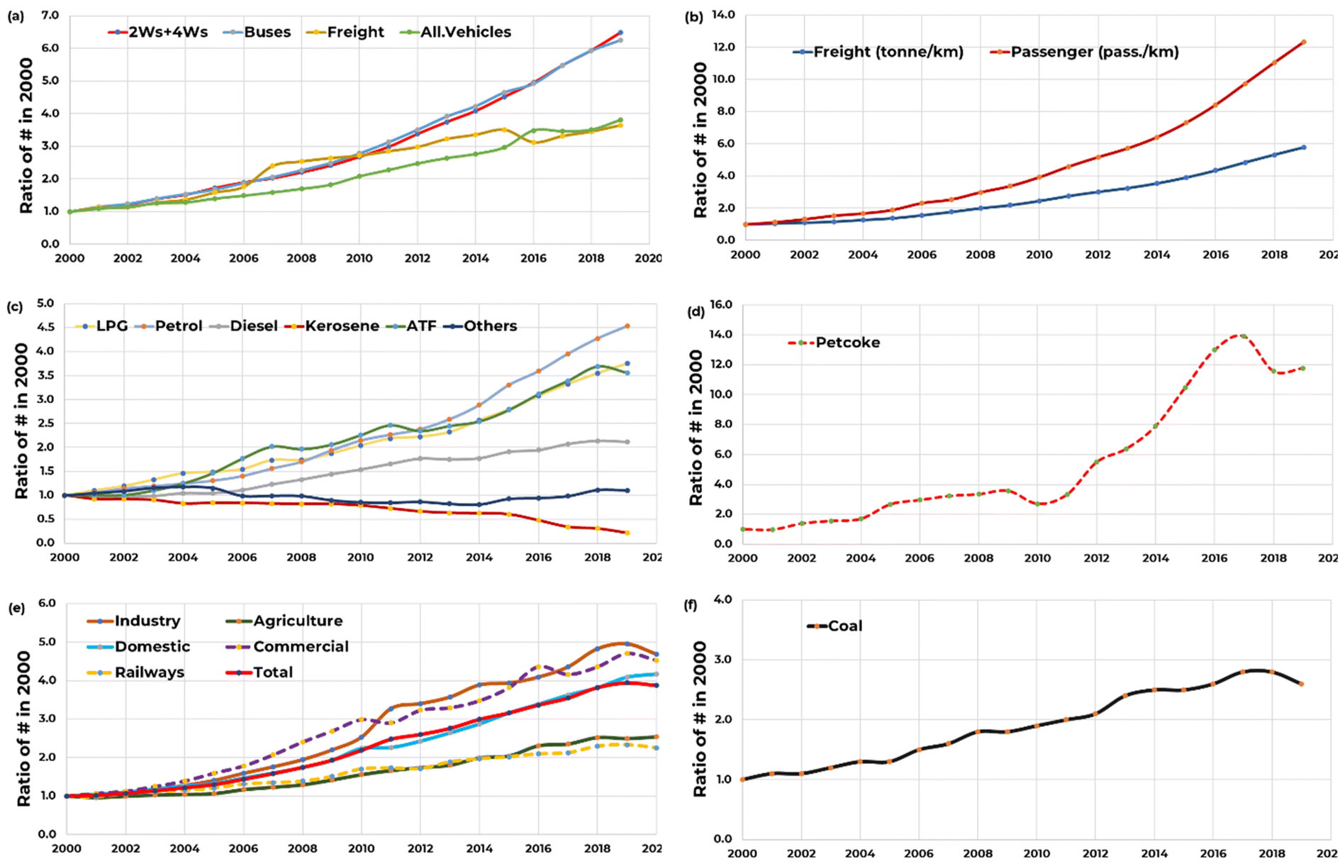 | ||
| Fig. 5 Evolution of fuel consumption and activity indicators with direct links to PM2.5 and other precursor emissions between 2000 and 2020, presented as a ratio of numbers in 2000: (a) number of vehicles (2 Ws + 4 Ws, buses, trucks, and all vehicles), (b) freight movement as tonnes per km and passenger movement as passengers per km, (c) annual fuel consumption (LPG, petrol, diesel, kerosene, ATF, and others), (d) petcoke consumption, (e) annual electricity consumption (in industry, domestic, railways, agriculture, commercial, and total) and (f) annual total coal consumption. | ||
Between 1995 and 2020, transport sector improved its standards 6 times, with the sulphur content reducing from 1% to 10 ppm. The Bharat-VI vehicle standards were introduced in 2020 and fuel standards were introduced in 2018 in Delhi and nationwide in 2020. While the standards improved periodically, most of these gains were lost to rapid increase in the number of vehicles on roads and their usage.46–48 The total number of registered vehicles in India touched 295 million in 2019. Of this 220 (75%), 38 (13%), 2 (0.7%), 14 (5%), and 20 (7%) million were 2-wheelers (2 Ws), 4-wheelers (4 Ws – including jeeps and sport utility vehicles), buses (intra- and inter-city), goods (light- and heavy-vehicles), and other non-road vehicles, respectively. Between 2011 and 2019, the total number of vehicles doubled and between 2000 and 2019, it increased 6 times (Fig. 5a). During these periods, passenger (2 Ws and 4 Ws) and commercial (buses and freight) vehicles had similar growth rates. The passenger vehicle usage also increased, 12.3 times to 22.6 billion passengers per km and freight movement increased 5.8 times to 2.7 billion tonnes per km negating most of the gains from fuel and vehicle standards introduced prior to Bharat VI (Fig. 5b).
The total fuel consumption in India is recorded at 26.3, 30.0, 83.2, 2.4, 8.0, and 42.8 million tonnes in 2020 for LPG, petrol, diesel, kerosene, aviation turbine fuel (ATF), and others, respectively. Compared to 2000, this is 3.8, 4.5, 2.1, 0.2, 3.6, and 1.1 times, respectively (Fig. 5c). Only fuel to show a decline in consumption in kerosene, mostly used for lighting and for some cooking in rural areas. Delhi was the first city to declare kerosene free in 2014, after its imports were banned in 2003. LPG is mostly consumed in the residential sector and some in the transport sector where petrol or diesel to gas conversion kits were available. A bump in the use of LPG is due to the start of Pradhan Mantri's Ujjwala Yojana (PMUY) in 2016, which added 90 million new connections across India in January 2022. Petrol is mostly consumed in the passenger vehicle sector. With an increase in the number of vehicles and their usage, total fuel consumption also increased over the years. Diesel is ∼30% of the total fuel consumed in 2020 and is used among all sectors – some passenger vehicles, all the heavy-duty vehicles including buses, non-road vehicles like tractors, generator sets at residential, commercial, and industrial locations, and agricultural pump sets. There is some decline in the use of diesel generator sets in cities, with more access to uninterrupted power supply from the grids and an addition of 50 GW of renewables in 2022.49 The other fuels category includes naphtha, fuel oil, lubricants, waxes, and refinery oil, mostly consumed in various industrial processes.
The consumption of petroleum coke (petcoke) increased dramatically in 2011–12 after the introduction of INR 400 coal tax per ton (Fig. 5d). Petcoke is one of the dirtiest fractions of crude processing with up to 6% of sulphur content and mostly used as a replacement of coal in the iron and steel and cement industries.50 In 2020, the total consumption of petcoke was recorded at 21.7 million tonnes, peaking at 25.6 million tonnes in 2018. In 2017, there were notions by the Environment Pollution (Prevention & Control) Authority (EPCA) to ban the import of petcoke, limit its use in the non-cement sector, and declare petcoke as a “regular fuel”.
The total electricity consumed in India is 1227 TWh in 2020–21 between industry (41%), agriculture (18%), domestic (26%), commercial (8%), railways (2%), and others (6%), which is on average 4.0 times the consumption levels in 2000–01 (Fig. 5e). Between 2000 and 2020, the average per-capita consumption doubled from 600 to 1200 kWh. Coal, diesel, and gas are responsible for 75% of 388 GW of installed power generation capacity with an average of 20% transmission losses. The total coal consumption in India was 910 million tonnes in 2019–20, which is on average 2.6 times the consumption levels in 2000–01 (Fig. 5f). Approximately 65% is utilized at power plants, followed by heavy industries like iron and steel, cement, and fertilizers, and some in the domestic sector for cooking and heating. Around 70% of the coal is mined in India and most of the imported coal is consumed in heavy industries to benefit from its low ash content and higher calorific value. Environmental regulations for coal-fired thermal power plants were amended in 2015, strengthening PM emission standards and introducing standards for SO2, NOx, and mercury.28 However, the implementation of these regulations is delayed for various reasons – the lack of preparedness from the operators due to covid-19 lockdowns in 2020–21. The share of SO2 and NOx emissions from the power plants is the largest, which contribute to PM2.5 concentrations via chemical transformation in the form of sulphates and nitrates over long distances. The full implementation of the new regulations is expected to reduce power plant contributions to total PM2.5 concentrations from current and planned units by up to 80%.27
4 Conclusions
The COVID-19 pandemic and the associated lockdowns (March–April 2020) provided a new normal for Indian cities – a realization that “clean air” and “blue skies” are possible also during the times when it is not raining. Starting on March 24th four consecutive lockdowns were announced, with the strictest regulations during the first lockdown period and slowly easing them during the fourth period and after. Restrictions enabled during these periods were (a) most activities from home for offices, schools, colleges, universities, and training institutions, (b) closure of markets, malls, construction activities, and most public spaces, (c) partial closure of small-, medium- and large-scale industries, (d) bans on open waste burning, (e) limited passenger and public transport movement – with the exception of police, press, and medical practitioners and some with special permissions on a need for basis, and (f) limited freight movement, which was eased after the first week in response to shortages for essential goods. Reduced activity at industries, including power plants for a short period reduced their share of pollution, work from home reduced the demand of mobility, and fewer vehicles on the road and curbs on construction led to limited or no dust resuspensions, thus resulting in better air quality across India with most improvements observed during the first period.51On average, every lockdown period witnessed at least 25% drop in PM pollution across India, most (as high as 70%) coming from cities. PM pollution is affected by all the known sources and all the regulations discussed above led to these drops.35,52 A climatological analysis of the satellite retrieval based AOD estimated a drop of 50% in the PM2.5 concentrations at the start of the lockdowns and slowing catching up to the decadal averages at the end of the 4th lockdown.53
The 2-month period provides evidence to argue that the only way to achieve “clean air” is by (a) cutting emissions at all the sources and (b) cutting emissions regionally and not just in cities as envisioned under the NCAP. While some programs like the promotion of electric vehicles for personal and public transport, increasing the number of LPG connections and access to refills in non-urban areas, and building of renewable-based power generation plants are helping to reduce the pollution burden in small doses, some hard decisions are required to enable and sustain larger reductions across sectors to reach both the national ambient standard of 40 μg m−3 and the WHO guideline of 5 μg m−3 for PM2.5 pollution in India.
Author contributions
We would also like to thank the anonymous reviewers for their contributions to this manuscript.Conflicts of interest
The authors declare no conflict of interest.Acknowledgements
We would like to acknowledge and thank Dr Randall Martin and his team of researchers and scientists in the Atmospheric Composition Analysis Group, the Washington University in St. Louis (WUSTL), USA, especially Dr Aaron van Donkelaar and Dr Erin McDuffie, for providing open access to the modelled databases and responding to our queries on the data structure and model structure. This research received no external funding. Pollution data summaries are available @ https://doi.org/10.5281/zenodo.7115052 and acitivity data summaries are available @ https://doi.org/10.5281/zenodo.7156314.References
- T. Ganguly, K. L. Selvaraj and S. K. Guttikunda, National Clean Air Programme (NCAP) for Indian cities: Review and outlook of clean air action plans, Atmos. Environ.: X, 2020, 8, 100096, DOI:10.1016/j.aeaoa.2020.100096.
- CPCB, Guidelines for Ambient Air Quality Monitoring; Central Pollution Control Board, Ministry of Environment Forests and Climate Change, Government of India, New Delhi, India, 2003 Search PubMed.
- M. Brauer, S. K. Guttikunda, K. A. Nishadh, S. Dey, S. N. Tripathi, C. Weagle and R. V. Martin, Examination of monitoring approaches for ambient air pollution: A case study for India, Atmos. Environ., 2019, 216, 116940, DOI:10.1016/j.atmosenv.2019.116940.
- P. Pant, R. M. Lal, S. K. Guttikunda, A. G. Russell, A. S. Nagpure, A. Ramaswami and R. E. Peltier, Monitoring particulate matter in India: recent trends and future outlook, Air Qual., Atmos. Health, 2018, 12, 45–58, DOI:10.1007/s11869-018-0629-6.
- D. Sharma and D. Mauzerall, Analysis of Air Pollution Data in India between 2015 and 2019, Aerosol Air Qual. Res., 2022, 22, 210204, DOI:10.4209/aaqr.210204.
- E. E. McDuffie, R. V. Martin, J. V. Spadaro, R. Burnett, S. J. Smith, P. O'Rourke, M. S. Hammer, A. van Donkelaar, L. Bindle and V. Shah, et al., Source sector and fuel contributions to ambient PM2.5 and attributable mortality across multiple spatial scales, Nat. Commun., 2021, 12, 3594, DOI:10.1038/s41467-021-23853-y.
- E. E. McDuffie, S. J. Smith, P. O'Rourke, K. Tibrewal, C. Venkataraman, E. A. Marais, B. Zheng, M. Crippa, M. Brauer and R. V. Martin, A global anthropogenic emission inventory of atmospheric pollutants from sector- and fuel-specific sources (1970–2017): an application of the Community Emissions Data System (CEDS), Earth Syst. Sci. Data, 2020, 12, 3413–3442, DOI:10.5194/essd-12-3413-2020.
- A. van Donkelaar, M. S. Hammer, L. Bindle, M. Brauer, J. R. Brook, M. J. Garay, N. C. Hsu, O. V. Kalashnikova, R. A. Kahn and C. Lee, et al., Monthly Global Estimates of Fine Particulate Matter and Their Uncertainty, Environ. Sci. Technol., 2021, 55, 15287–15300, DOI:10.1021/acs.est.1c05309.
- K. Balakrishnan, S. Dey, T. Gupta, R. S. Dhaliwal, M. Brauer, A. J. Cohen, J. D. Stanaway, G. Beig, T. K. Joshi and A. N. Aggarwal, et al., The impact of air pollution on deaths, disease burden, and life expectancy across the states of India: the Global Burden of Disease Study 2017, The Lancet Planetary Health, 2019, 3, e26–e39, DOI:10.1016/s2542-5196(18)30261-4.
- G. K. Saw, S. Dey, H. Kaushal and K. Lal, Tracking NO2 emission from thermal power plants in North India using TROPOMI data, Atmos. Environ., 2021, 259, 118514, DOI:10.1016/j.atmosenv.2021.118514.
- B. de Foy and J. J. Schauer, An improved understanding of NOx emissions in South Asian megacities using TROPOMI NO2 retrievals, Environ. Res. Lett., 2022, 17, 024006, DOI:10.1088/1748-9326/ac48b4.
- S. Dey, B. Purohit, P. Balyan, K. Dixit, K. Bali, A. Kumar, F. Imam, S. Chowdhury, D. Ganguly and P. Gargava, et al., A Satellite-Based High-Resolution (1-km) Ambient PM2.5 Database for India over Two Decades (2000–2019): Applications for Air Quality Management, Remote Sens., 2020, 12, 3872 CrossRef.
- M. Crippa, D. Guizzardi, E. Pisoni, E. Solazzo, A. Guion, M. Muntean, A. Florczyk, M. Schiavina, M. Melchiorri and A. F. Hutfilter, Global anthropogenic emissions in urban areas: patterns, trends, and challenges, Environ. Res. Lett., 2021, 16, 074033, DOI:10.1088/1748-9326/ac00e2.
- M. Crippa, E. Solazzo, G. Huang, D. Guizzardi, E. Koffi, M. Muntean, C. Schieberle, R. Friedrich and G. Janssens-Maenhout, High resolution temporal profiles in the Emissions Database for Global Atmospheric Research, Sci. Data, 2020, 7, 121, DOI:10.1038/s41597-020-0462-2.
- A. Upadhyay, S. Dey and P. Goyal, A comparative assessment of regional representativeness of EDGAR and ECLIPSE emission inventories for air quality studies in India, Atmos. Environ., 2020, 223, 117182, DOI:10.1016/j.atmosenv.2019.117182.
- M. Li, Q. Zhang, J. I. Kurokawa, J. H. Woo, K. He, Z. Lu, T. Ohara, Y. Song, D. G. Streets and G. R. Carmichael, et al., MIX: a mosaic Asian anthropogenic emission inventory under the international collaboration framework of the MICS-Asia and HTAP, Atmos. Chem. Phys., 2017, 17, 935–963, DOI:10.5194/acp-17-935-2017.
- J. Kurokawa and T. Ohara, Long-term historical trends in air pollutant emissions in Asia: Regional Emission inventory in ASia (REAS) version 3, Atmos. Chem. Phys., 2020, 20, 12761–12793, DOI:10.5194/acp-20-12761-2020.
- C. Venkataraman, M. Brauer, K. Tibrewal, P. Sadavarte, Q. Ma, A. Cohen, S. Chaliyakunnel, J. Frostad, Z. Klimont and R. V. Martin, et al., Source influence on emission pathways and ambient PM2.5 pollution over India (2015–2050), Atmos. Chem. Phys., 2018, 18, 8017–8039, DOI:10.5194/acp-18-8017-2018.
- T. Jayarathne, C. E. Stockwell, P. V. Bhave, P. S. Praveen, C. M. Rathnayake, M. R. Islam, A. K. Panday, S. Adhikari, R. Maharjan and J. D. Goetz, et al., Nepal Ambient Monitoring and Source Testing Experiment (NAMaSTE): emissions of particulate matter from wood- and dung-fueled cooking fires, garbage and crop residue burning, brick kilns, and other sources, Atmos. Chem. Phys., 2018, 18, 2259–2286, DOI:10.5194/acp-18-2259-2018.
- M. Zhong, E. Saikawa, A. Avramov, C. Chen, B. Sun, W. Ye, W. C. Keene, R. J. Yokelson, T. Jayarathne and E. A. Stone, et al., Nepal Ambient Monitoring and Source Testing Experiment (NAMaSTE): emissions of particulate matter and sulfur dioxide from vehicles and brick kilns and their impacts on air quality in the Kathmandu Valley, Nepal, Atmos. Chem. Phys., 2019, 19, 8209–8228, DOI:10.5194/acp-19-8209-2019.
- E. A. Marais and C. Wiedinmyer, Air Quality Impact of Diffuse and Inefficient Combustion Emissions in Africa (DICE-Africa), Environ. Sci. Technol., 2016, 50, 10739–10745, DOI:10.1021/acs.est.6b02602.
- M. S. Hammer, A. van Donkelaar, C. Li, A. Lyapustin, A. M. Sayer, N. C. Hsu, R. C. Levy, M. J. Garay, O. V. Kalashnikova and R. A. Kahn, et al., Global Estimates and Long-Term Trends of Fine Particulate Matter Concentrations (1998–2018), Environ. Sci. Technol., 2020, 54, 7879–7890, DOI:10.1021/acs.est.0c01764.
- A. N. Rose, J. J. McKee, M. L. Urban, E. A. Bright and K. M. Sims, LandScan, 2018 Search PubMed.
- L. Dandona, R. Dandona, G. A. Kumar, D. K. Shukla, V. K. Paul, K. Balakrishnan, D. Prabhakaran, N. Tandon, S. Salvi and A. P. Dash, et al., Nations within a nation: variations in epidemiological transition across the states of India, 1990–2016 in the Global Burden of Disease Study, Lancet, 2017, 390, 2437–2460, DOI:10.1016/s0140-6736(17)32804-0.
- S. Mani, A. Jain, S. Tripathi and C. F. Gould, The drivers of sustained use of liquified petroleum gas in India, Nat. Energy, 2020, 5, 450–457, DOI:10.1038/s41560-020-0596-7.
- HEI, State of global air, A Special Report on Global Exposure to Air Pollution and its Health Impacts, ISSN 2578–6873; Health Effects Institute: Boston, USA, 2020 Search PubMed.
- M. Cropper, R. Cui, S. Guttikunda, N. Hultman, P. Jawahar, Y. Park, X. Yao and X.-P. Song, The mortality impacts of current and planned coal-fired power plants in India, Proc. Natl. Acad. Sci., 2021, 118, e2017936118, DOI:10.1073/pnas.2017936118.
- S. K. Guttikunda and P. Jawahar, Atmospheric emissions and pollution from the coal-fired thermal power plants in India, Atmos. Environ., 2014, 92, 449–460, DOI:10.1016/j.atmosenv.2014.04.057.
- P. Maheshwarkar, A. Ralhan, R. Sunder Raman, K. Tibrewal, C. Venkataraman, A. Dhandapani, R. N. Kumar, S. Mukherjee, A. Chatterje and S. Rabha, et al., Understanding the Influence of Meteorology and Emission Sources on PM2.5 Mass Concentrations Across India: First Results From the COALESCE Network, J. Geophys. Res.: Atmos., 2022, 127, e2021JD035663, DOI:10.1029/2021JD035663.
- S. K. Guttikunda and B. R. Gurjar, Role of meteorology in seasonality of air pollution in megacity Delhi, India, Environ. Monit. Assess., 2012, 184, 3199–3211, DOI:10.1007/s10661-011-2182-8.
- S. Guttikunda and P. Jawahar, Can We Vacuum Our Air Pollution Problem Using Smog Towers?, Atmosphere, 2020, 11, 922 CrossRef CAS.
- V. Lalchandani, D. Srivastava, J. Dave, S. Mishra, N. Tripathi, A. K. Shukla, R. Sahu, N. M. Thamban, S. Gaddamidi and K. Dixit, et al., Effect of Biomass Burning on PM2.5 Composition and Secondary Aerosol Formation During Post-Monsoon and Winter Haze Episodes in Delhi, J. Geophys. Res.: Atmos., 2022, 127, e2021JD035232, DOI:10.1029/2021JD035232.
- A. Kumar, H. Hakkim, B. Sinha and V. Sinha, Gridded 1 km × 1 km emission inventory for paddy stubble burning emissions over north-west India constrained by measured emission factors of 77 VOCs and district-wise crop yield data, Sci. Total Environ., 2021, 789, 148064, DOI:10.1016/j.scitotenv.2021.148064.
- G. Beig, M. P. George, S. K. Sahu, A. Rathod, S. Singh, S. Dole, B. Murthy, R. Latha, S. Tikle and H. Trimbake, Towards baseline air pollution under COVID-19: implication for chronic health and policy research for Delhi, India, Curr. Sci., 00113891, 2020, 119 Search PubMed.
- K. Ravindra, T. Singh, A. Biswal, V. Singh and S. Mor, Impact of COVID-19 lockdown on ambient air quality in megacities of India and implication for air pollution control strategies, Environ. Sci. Pollut. Res., 2021, 28, 21621–21632, DOI:10.1007/s11356-020-11808-7.
- V. Singh, S. Singh, A. Biswal, A. P. Kesarkar, S. Mor and K. Ravindra, Diurnal and temporal changes in air pollution during COVID-19 strict lockdown over different regions of India, Environ. Pollut., 2020, 266, 115368, DOI:10.1016/j.envpol.2020.115368.
- S. Chowdhury, S. Dey, S. Guttikunda, A. Pillarisetti, K. R. Smith and L. Di Girolamo, Indian annual ambient air quality standard is achievable by completely mitigating emissions from household sources, Proc. Natl. Acad. Sci. U. S. A., 2019, 116, 10711–10716, DOI:10.1073/pnas.1900888116.
- A. Jain, S. Tripathi, S. Mani, S. Patnaik, T. Shahidi and K. Ganesan, Access to Clean Cooking Energy and Electricity Survey of States 2018, Council on Energy, Environment and Water, New Delhi, India, 2018 Search PubMed.
- M. L. Cropper, S. Guttikunda, P. Jawahar, Z. Lazri, K. Malik, X. P. Song and X. Yao, Applying Benefit-Cost Analysis to Air Pollution Control in the Indian Power Sector, J. Benefit Cost Anal., 2019, 10, 185–205, DOI:10.1017/bca.2018.27.
- UEinfo, Air Pollution Knowledge Assessments (APnA) City Program Covering 50 Airsheds and 60 Cities in India, 2019, https://www.urbanemissions.info Search PubMed.
- S. K. Guttikunda, K. A. Nishadh and P. Jawahar, Air pollution knowledge assessments (APnA) for 20 Indian cities, Urban Climate, 2019, 27, 124–141, DOI:10.1016/j.uclim.2018.11.005.
- S. Sarkar, A. Chauhan, R. Kumar and R. P. Singh, Impact of Deadly Dust Storms (May 2018) on Air Quality, Meteorological, and Atmospheric Parameters Over the Northern Parts of India, GeoHealth, 2019, 3, 67–80, DOI:10.1029/2018GH000170.
- P. Chaudhary, S. Garg, T. George, M. Shabin, S. Saha, S. Subodh and B. Sinha, Underreporting and open burning – the two largest challenges for sustainable waste management in India, Resour., Conserv. Recycl., 2021, 175, 105865, DOI:10.1016/j.resconrec.2021.105865.
- D. H. Cusworth, L. J. Mickley, M. P. Sulprizio, T. Liu, M. E. Marlier, R. S. DeFries, S. K. Guttikunda and P. Gupta, Quantifying the influence of agricultural fires in northwest India on urban air pollution in Delhi, India, Environ. Res. Lett., 2018, 13, 044018, DOI:10.1088/1748-9326/aab303.
- G. Beig, S. K. Sahu, A. Rathod, S. Tikle, V. Singh and B. S. Sandeepan, Role of meteorological regime in mitigating biomass induced extreme air pollution events, Urban Climate, 2021, 35, 100756, DOI:10.1016/j.uclim.2020.100756.
- R. Goel and S. K. Guttikunda, Evolution of on-road vehicle exhaust emissions in Delhi, Atmos. Environ., 2015, 105, 78–90, DOI:10.1016/j.atmosenv.2015.01.045.
- S. K. Guttikunda and D. Mohan, Re-fueling road transport for better air quality in India, Energy Policy, 2014, 68, 556–561, DOI:10.1016/j.enpol.2013.12.067.
- N. Singh, T. Mishra and R. Banerjee, Emission inventory for road transport in India in 2020: framework and post facto policy impact assessment, Environ. Sci. Pollut. Res., 2022, 29, 20844–20863, DOI:10.1007/s11356-021-17238-3.
- S. M. Deorah, N. Abhyankar, S. Arora, K. Chawla and A. A. Phadke, Assessing the Key Requirements for 450 GW of Renewable Capacity in India by 2030, Lawrence Berkeley National Laboratory, USA, 2021 Search PubMed.
- T. Biswas and K. Ganesan, Petcoke Use in India's Iron and Steel Industry, Council on Energy Environment and Water, New Delhi, India, 2020 Search PubMed.
- CPCB, Impact of Lockdowns 25th March to 15th April on Air Quality, 2020 Search PubMed.
- G. I. Gkatzelis, J. B. Gilman, S. S. Brown, H. Eskes, A. R. Gomes, A. C. Lange, B. C. McDonald, J. Peischl, A. Petzold and C. R. Thompson, et al., The global impacts of COVID-19 lockdowns on urban air pollution: A critical review and recommendations, Elementa: Science of the Anthropocene, 2021, 9, DOI:10.1525/elementa.2021.00176.
- Y. Sathe, P. Gupta, M. Bawase, L. Lamsal, F. Patadia and S. Thipse, Surface and satellite observations of air pollution in India during COVID-19 lockdown: Implication to air quality, Sustainable Cities and Society, 2021, 66, 102688, DOI:10.1016/j.scs.2020.102688.
Footnote |
| † Electronic supplementary information (ESI) available. See https://doi.org/10.1039/d2ea00027j |
| This journal is © The Royal Society of Chemistry 2022 |