
 Open Access Article
 This Open Access Article is licensed under a Creative Commons Attribution-Non Commercial 3.0 Unported Licence
Anthropogenic influences on Zambian water quality: hydropower and land-use change†
R. Scott
Winton
 *ab,
Cristian R.
Teodoru
a,
Elisa
Calamita
ab,
Fritz
Kleinschroth
c,
Kawawa
Banda
d,
Imasiku
Nyambe
d and
Bernhard
Wehrli
ab
*ab,
Cristian R.
Teodoru
a,
Elisa
Calamita
ab,
Fritz
Kleinschroth
c,
Kawawa
Banda
d,
Imasiku
Nyambe
d and
Bernhard
Wehrli
ab
aInstitute of Biogeochemistry and Pollutant Dynamics, ETH Zurich, 8092 Zurich, Switzerland. E-mail: scott.winton@gmail.com
bDepartment of Surface Waters, Eawag, Swiss Federal Institution of Aquatic Science and Technology, 6047 Kastanienbaum, Switzerland
cEcosystem Management, Department of Environmental Systems Science, ETH Zurich, 8092 Zurich, Switzerland
dIntegrated Water Resources Management Centre, C/O Geology Department, School of Mines, University of Zambia, P. O. Box 32379, Lusaka, Zambia
First published on 27th May 2021
Abstract
The Zambezi River Basin in Southern Africa is undergoing rapid development and population growth. Agricultural intensification, urbanization and future development of hydropower dams will likely lead to a degradation of surface water quality, but there have been few formal assessments of where, how and why these changes impact specific water quality parameters based on in situ data spanning a large region. We sampled a large suite of biogeochemical water quality parameters at 14 locations in four field campaigns in central and southern Zambia in 2018 and 2019 to characterize seasonal changes in water quality in response to large hydropower dams and human landscape transformations. We find that the major rivers (Zambezi and Kafue) are very clean with extremely low concentrations of solutes, but suffer from thermal changes, hypoxia and loss of suspended sediment below dams. Smaller tributaries with a relatively large anthropogenic landcover footprint in their catchments show signs of pollution in the form of higher concentrations of nutrients and dissolved ions. We find significant relationships between crop and urban land cover metrics and selected water quality metrics (i.e. conductivity, phosphorus and nitrogen) across our data set. These results reflect a very high-quality waterscape exhibiting some hotspots of degradation associated with specific human activities. We anticipate that as agricultural intensification, urbanization and future hydropower development continue to accelerate in the basin, the number and extent of these hotspots of water quality degradation will grow in response. There is an opportunity for governments, managers and industry to mitigate water quality degradation via investment in sustainable infrastructure and practice, such as wastewater treatment, environmental dam operations, or riparian protection zones.
Environmental significanceSub-Saharan Africa will undergo dramatic environmental changes this century because of rapid population growth and economic development. The integrity of its water resources face an uncertain future and baseline understanding of the relationship between human activities and water quality are limited because of sparse data. In this study, we provide evidence for causal linkages between hydropower dams, urbanization and agriculture and surface water quality based on extensive field observations in the Zambian part of the Zambezi basin. These findings provide an empirical foundation for informing water quality monitoring and management strategies to counteract water pollution as dams, cities and agriculture expand in the region. |
Introduction
Sub-Saharan Africa (SSA) is experiencing some of the steepest rates of population growth in the world, with United Nations data predicting a tripling to occur before the end of the 21st century.1 In addition, the region faces accelerating external resource demands from globalization, driving expansion of industrialized agriculture, natural resource extraction and power generation. These developments will transform the region over the coming decades and a major geopolitical concern is whether existing water resources will be able to sustain such rapid growth of cities and economies.In the Zambezi, Africa's fourth largest river basin, and the most important draining into the Indian Ocean, eight nations share the watershed and its water, which provides hydroelectric energy, irrigation and domestic water for roughly 50 million people.2 Each of these uses has the potential to change the physical and chemical properties of surface waters. Hydropower reservoirs can alter river thermal regimes, create hypoxic dead zones and store sediments and coarse materials behind dams.3,4 Wastewater from cities and towns loads nutrients and other solutes into streams, especially where treatment infrastructure is not available. Agricultural lands can leach applied fertilizers and pesticides and tillage enhances erosion and sedimentation. Human enterprise inevitably leaves biogeochemical impressions on its waterways, typically degrading the value that aquatic systems can provide for society. Both professional scientists and the general public, typically refer to such changes in water physico-chemical properties arising from human activities as changes in “water quality,” a subjective term lacking a formal technical definition. We use “water quality” in this paper as a short-hand for referring to values of various physical and or chemical properties that we have measured in reference to waters that lack human influence. That is, waters far from human intervention we may define as being of “excellent quality” and waters with higher concentrations of solutes we assess to have been altered or degraded by some (typically) human process.
In the heavily populated and industrialized regions of the world, freshwaters are commonly found to be in a state of severe degradation via chemical and microbial pollution.5 Much of the Zambezi Basin, in contrast, is sparsely populated with many river reaches in a relatively intact state.6 The region is changing rapidly, however, and it is not clear how resilient the quality of surface waters will be to developmental trends. Damming is accelerating in the basin, with 11 to 25 hydropower projects under construction or in a planning stage,7 augmenting 5 existing large dams.8 The population of Zambia, the country comprising the largest portion of the Zambezi Basin (40.7%), is growing at a rate of 2.9% per year and expected to triple by 2050.9 There will be, of course, increased food consumption, which will necessitate commensurate increases in agricultural productivity. In addition, the government of Zambia has put in place accelerated efforts to increase agricultural exports. Expansion of croplands and demand for increased yields will necessitate accelerating use of fertilizers and water abstractions for irrigation. Will the rivers be able to absorb the excess nutrients that will inevitably leach from all these new fields without experiencing major trophic changes? Will wastewater treatment infrastructure keep pace with the rapid rate of urbanization? To understand the potential future of Zambia's surface water quality field observations spanning broad geographies and targeted at potential sources of pollution are required.
In order to assess the status and potential trajectory of surface waters we studied the biogeochemical quality in Zambia's major rivers, focusing on physico-chemical parameters, such as inorganic ions and nutrients (we omitted metals and organic pollutants). To this end, we implemented a series of field campaigns in 2018 and 2019. We sampled a wide range of physical and chemical properties of the river water bracketing Zambia's two largest hydropower reservoirs, the Kariba Reservoir on the Zambezi and the Itezhi-Tezhi Reservoir on the Kafue River to test for effects of hydropower dams. We also sampled three smaller tributaries: Maramba, Chongwe, Little Chongwe draining some of the more intensively-transformed sub-catchments in order to test for changes in water quality related to urban and agricultural land uses.
In this paper, we summarize broad spatial and seasonal patterns of hotspots of water quality changes associated with human activities in Zambia. We focus on hydropower and the role that two large dams play in changing downstream water quality and on urban and agricultural pollution sources. Our aim is to link specific types of water quality changes to drivers and improve understanding of the present patterns of water quality in Zambia. Based on this analysis we make coarse predictions on where and why Zambezi water quality might be degraded in the future in the context of regional and global change.
Methods
Study area
We focused our field study on the western half of Zambia, with sampling points bracketing major hydropower reservoirs on the Zambezi and Kafue River main stems (Fig. 1; Table 1). The inflows of both reservoirs are not easily accessible, so we sampled upstream at the nearest point accessible by road.10 We also sampled surface and deep waters (50 m depth) of the Kariba and Itezhi-Tezhi reservoirs near the dam wall (KAS, KAD, ITS, ITD) in order to assess stratification strength and any differences between epilimnetic and hypolimnetic waters.11 To test for effects of anthropogenic landcover change on stream water quality, we sampled three smaller streams (Maramba–MAR, Chongwe – CHO, Little Chongwe – LCH) draining sub-catchments (510 km2, 5130 km2 and 530 km2, respectively) characterized by dense urban and/or agricultural areas. To provide some context for the impacted small streams we additionally sampled a few minimally-impacted streams draining small catchments of mostly protected areas (Zambezi Source Protected Forest Area and North Swaka Forest Reserve north of Lusaka) during the final field campaign and during a follow-up study in November 2019 (Fig. S1†). The study region's climate is characterized by intense hydrologic seasonality, with a 5 to 6 month rainy season accounting for 95% of annual precipitation that gives way to a half-year of nearly no rainfall. As a result, river flows and the connectivity between surface waters and catchments follow a corresponding high-low, on–off modality.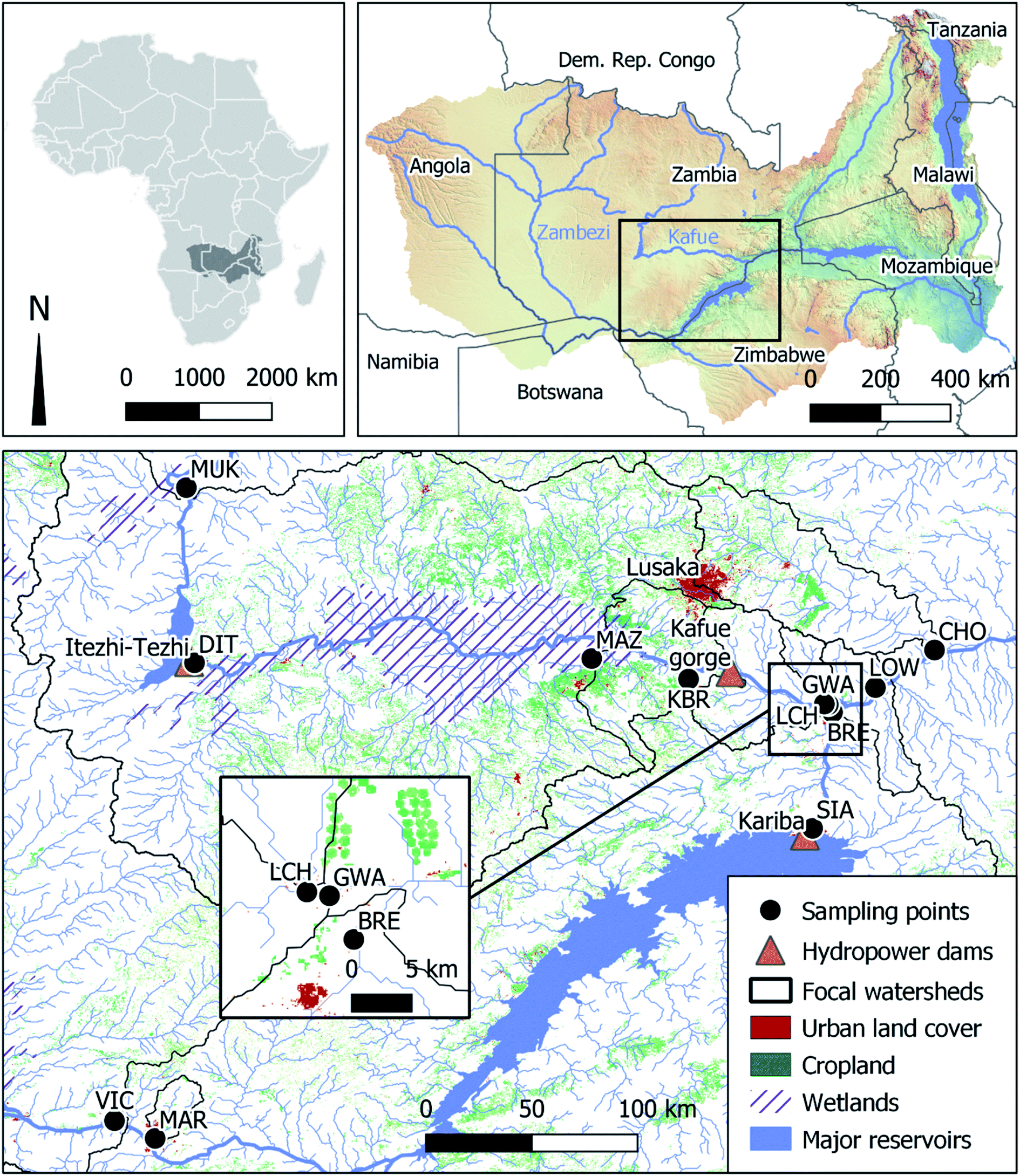 | ||
| Fig. 1 Maps of Zambezi Basin and sampling points on the Kafue and Zambezi Rivers and tributaries. River and catchment delineations are from the HydroSheds database.13 Landcover is from Copernicus Global Land Service.14 Elevation data is courtesy of the United States Geologic Survey. Dams, wetlands and water bodies are from Open Street Map (www.openstreetmap.org). | ||
| ID | River | Distance from dam | Latitude | Longitude |
|---|---|---|---|---|
| km downstream | Decimal degrees | |||
| VIC | Zambezi | Upstream −150 | 17.810 °S | 25.673 °E |
| SIA | Zambezi | 3 | 16.504 °S | 28.792 °E |
| BRE | Zambezi | 70 | 15.985 °S | 28.881 °E |
| LOW | Zambezi | 110 | 15.719 °S | 29.335 °E |
| MUK | Kafue | Upstream −65 | 14.981 °S | 25.994 °E |
| DIT | Kafue | 1 | 15.764 °S | 26.030 °E |
| MAZ | Kafue | 300 | 15.745 °S | 27.805 °E |
| KBR | Kafue | 430 | 15.837 °S | 28.237 °E |
| GWA | Kafue | 520 | 15.951 °S | 28.862 °E |
| CHO | Chongwe | NA | 15.709 °S | 29.339 °E |
| LCH | L. Chongwe | NA | 15.948 °S | 28.844 °E |
| MAR | Maramba | NA | 17.889 °S | 25.854 °E |
Discharge of the Zambezi River at Victoria Falls spans more than an order of magnitude12 from minimum flows of around 240 m3 s−1 in October/November to about 3780 m3 s−1 in April/May (average 1420 m3 s−1) (daily data between 2010 and 2013, data from Teodoru et al., 2015). Even more intense seasonality occurs on the upper Kafue River where discharge at Hook Bridge (upstream of the Itezhi-Tezhi Reservoir) ranges from a minimum of 40 m3 s−1 during dry season to a maximum of 1230 m3 s−1 during wet season (average 330 m3 s−1) (daily data between 2010 and 2013, from Teodoru et al., 2015).
Field sampling
In order to capture the region's seasonally variable hydrologic conditions, we collected surface water samples from all sampled points four times between March 2018 and March 2019 at approximately even intervals spanning both wet and dry seasons. In most cases we were able to sample from a boat or floating pontoon to avoid bias from hyporheic or littoral influence at the river margins. We measured pH, conductivity and water temperature in situ using a YSI Professional Series multi-parameter sonde (Yellow Springs, Ohio). We measured dissolved oxygen (DO) using a second YSI optical dissolved oxygen probe. We calibrated pH and oxygen sensors daily before taking measurements. We filtered water samples through pre-combusted and pre-weighed glass fiber F filters for total suspended solids (TSS) determination, collecting subsamples of the filtrate for analysis of dissolved ions, nutrients, and dissolved organic carbon (DOC) (in borosilicate glass vials). We sun-dried filters for subsequent analysis of particulate matter. For analysis of chlorophyll we collected a second filter, which we stored in 95% ethanol and in the dark for subsequent field processing and analysis. We also collected unfiltered surface water samples for analysis of bulk nutrients and alkalinity. We separately collected water samples for dissolved inorganic carbon (DIC), which we filtered through 0.2 μM syringe filters in 12 ml exetainers without headspace. All water samples were collected in triplicate in order to estimate error associated with our entire sampling and analytical workflow and if necessary, discard outliers. We kept samples cool during handling and storage.Sample analysis
Landcover classification
We used a discrete global land cover classification at 100 m resolution for 2019 (ref. 14) to determine cropland and urban areas as potential sources of water pollution. For each of the 10 sampling points (excluding the locations directly below ITT and Kariba dams), we defined the catchment corresponding to each sampling point by combining all sub-catchments from the Hydrosheds global database13 that were located upstream using QGIS version 3.10.We then calculated the effect of pixels in each of the two land cover classes upstream of each sampling point. To take into account the loss of compound concentration via dilution, biological uptake and sedimentation over distance and time we included a parametric weighted distance function. The resulting weighted pixel area is based on the Euclidean distance from the sampling point and an exponential decay function describing loss of solute concentration. Following the approach of Liberoff et al. (2019),16 we calculated the weight based on an exponential curve reparametrized as a function of the half-life of a given indicator. We then assumed that the weight decays exponentially as a function of the distance between a given land use pixel and the sampling point. Based on visual interpretation of the catchment morphology for each sampling point, Euclidean distance (as suggested by Liberoff et al. 2019) was sufficient to capture the dominant land cover types at the given spatial resolution. For a given indicator, we then calculated the effective contribution area of a land cover class to a given river sampling point. To account for the size difference between different catchments and the dilution effect of larger streams, we then calculated the percentage of the weighted land cover area of the total catchment area. Due to the absence of reliable gauging stations at most sampling sites, catchment size was the best available indicator for streamflow. All spatial analyses were carried out using the raster package17 in R version 3.6.1.18
Data analysis
We fed the outputs of all analyses into a master spreadsheet (reference data set), which we then analyzed and visualized using R version 3.6.1.18 To explore the data set for spatial and seasonal patterns and to identify hotspots we created a heat map of the data set, with all values standardized to fall between 0 (corresponding to the lowest value in the data set) and 1 (corresponding to the highest). We inverted dissolved oxygen, so that hypoxic values would be close to 1 (and thus be highlighted as hotspots) with the highest oxygen value scaled to 0. We converted pH to distance from pH 7 (defined as 0), so that extremely acidic or basic values would be closer to 1.To assess the potential role of landcover changes as drivers of water quality degradation we built simple linear regression models in R, using percent effective cropland cover with a 10 km decay constant and percent effective urban cover with a 100 km decay constant as explanatory variables. We chose these constants because they fall within the range reported by Liberoff et al. (2019) in a subtropical setting and because pollutants leaching from fertilizer should already be in mineral form (i.e. NO3−, PO43−) and more easily removed through assimilation into biomass, whereas pollutants in municipal wastewater are more likely to be bound to organic materials and require additional mineralization steps prior to uptake. For response variables we used specific conductivity (SpC), digestible phosphorus and digestible nitrogen. We did not assess additional response variables because other ions would be correlated with conductivity and mineral nutrients were often below limits of quantification making quantitative modelling efforts impractical.
Results and discussion
Spatial and temporal water quality hotspots
In general, the water chemistry of the major rivers in western Zambia reflects very clean conditions, with low concentrations of nutrients, other solutes and suspended particles. This is especially the case in the upper Zambezi where residents report routinely drinking river water without any chemical pre-treatment. The Kafue shows slightly elevated concentrations of some solutes compared to the Zambezi, but both major rivers exhibit concentrations at least one order of magnitude lower for many parameters, compared to the three smaller tributaries we sampled that drain catchments more intensively-modified by human activities. These smaller tributaries appear as hotspots of contamination in a waterscape otherwise characterized by oligotrophy (Fig. 2). Other obvious hotspots emerge for dissolved oxygen (hypoxia) and DOC associated with the middle sections of the Kafue River and hypolimnetic waters of the Kariba and Itezhi-Tezhi Reservoirs. | ||
| Fig. 2 Heat map of water quality parameters observed during four seasons in surface waters of western Zambia (S1: Mar. 2018, S2: Jul. 2018, S3: Oct. 2018, S4: Feb. 2019). All values are scaled by parameter from 0 (minimum) to 1 (maximum). Dissolved oxygen (DO) is inverted so that minimum values (hypoxia) appear red. We expressed pH as a deviation from 7, so that extreme values, whether acidic or basic, would appear redder; the most extreme cases are marked with “−” for basic and “+” for acidic. Dotted frames highlight reservoirs. Complete dataset with actual un-scaled values is available at (https://doi.org/10.3929/ethz-b-000476426). | ||
Hotspots of hypoxia in the study area follow expected patterns governed by well-documented biogeochemical processes. In the deep water of lakes and reservoirs, hypoxia is driven by persistent thermal stratification that occurs during warmer months of the year in most tropical reservoirs3 including Kariba19 and Itezhi-Tezhi.20 Floodplain dynamics drive hypoxia across associated reaches of the Kafue River. The Kafue Flats, a vast seasonal floodplain, consumes river water oxygen via intense decomposition of organic matter, especially during the falling phase of the hydrologic cycle.21 The Kafue experiences hypoxia driven by both natural floodplain processes and the artificial process of deep-water release from the Itezhi-Tezhi Reservoir for power production.
Seasonality is also evident in the hotspots of nutrients and solutes in the smaller tributaries. Concentrations are highest during the rainy seasons and relatively low in most cases during the dry seasons (Fig. 3). This pattern can be explained by seasonal differences in solute mobility. During the dry season many streams have low flow or no flow and there is little connectivity between pollution sources and perennial streams. The onset of rains flushes solutes from the landscape and restores hydraulic connectivity to river networks. For the major rivers (Kafue and Zambezi), this effect is relatively subtle or even undetectable for most solutes, presumably because of the large dilution capacity of these waterways. In contrast, the smaller waterways exhibit multi-fold increases in solute concentrations.
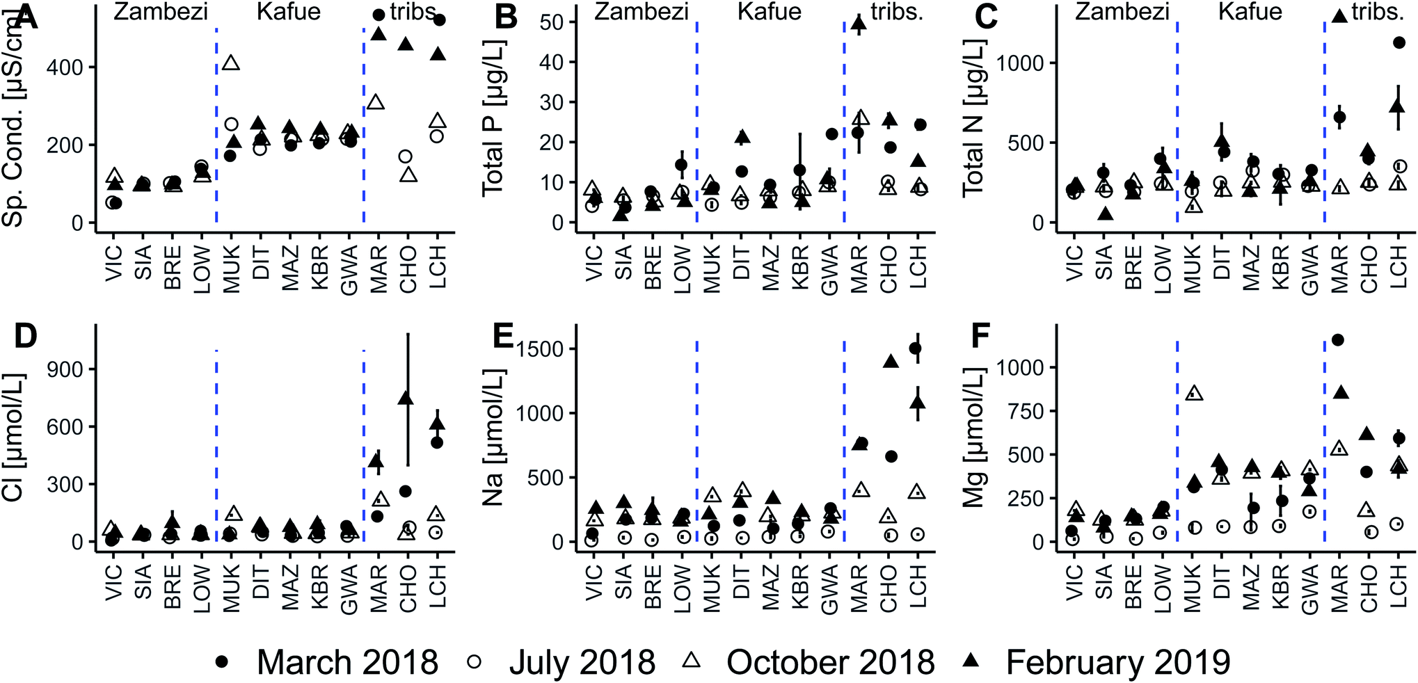 | ||
| Fig. 3 Selected water quality parameters illustrating differences in specific conductivity (A), concentrations of total phosphorus (B), total nitrogen (C), chloride (D), sodium (E) and magnesium (F) between Zambezi, Kafue and tributaries (left, center and right, respectively, of each panel). Tributaries exhibit higher concentrations during rainy seasons (solid symbols) compared to dry seasons (hollow symbols). | ||
Dams and altered thermal regimes
The different turbine intake designs of Kariba and Itezhi-Tezhi dams lead to dramatically different patterns of downstream temperature response. At Itezhi-Tezhi turbinated water is withdrawn from well below the depth of the seasonally-forming thermocline, meaning that downstream Kafue River tail water was typically colder than that observed upstream during the same season (Fig. 4). This thermal effect was most extreme at the end of the 2018 dry season (October: δT = −6 C), modest during rainy seasons (March 2018: δT = −2; February 2019: δT = −3), and absent during the cool dry season of 2018 when upstream Kafue River water was cold and the reservoir well-mixed (July 2018; δT = 0). These data indicate that the Itezhi-Tezhi Dam generates cold-water pollution for the downstream Kafue River during reservoir stratification.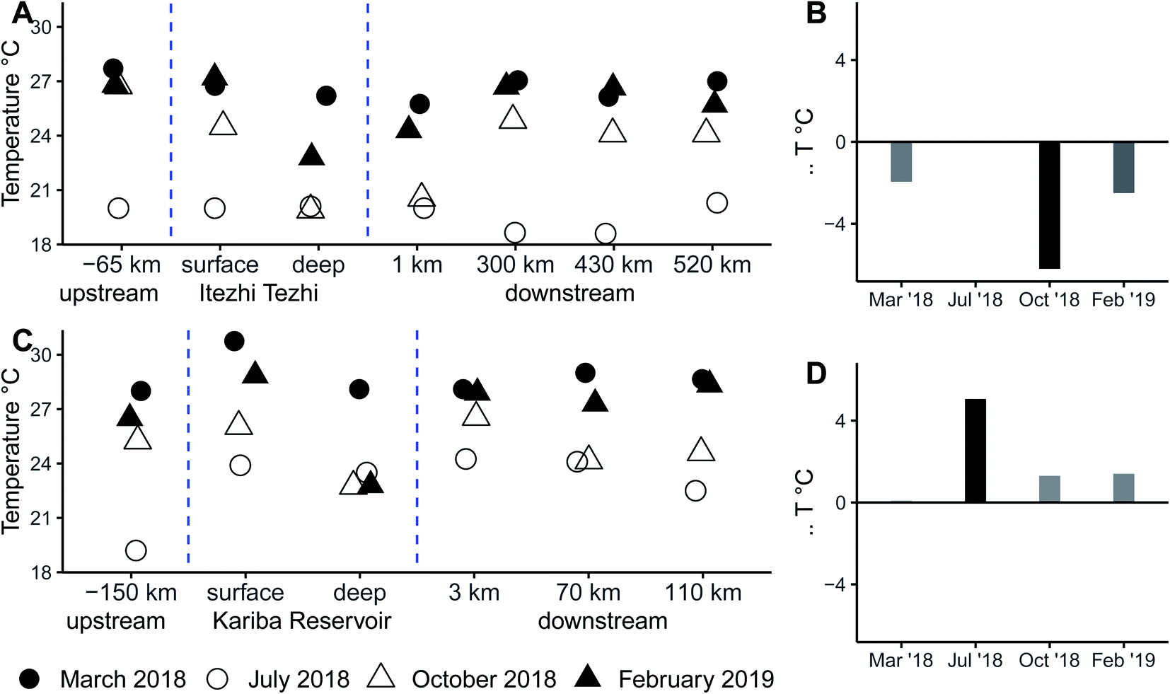 | ||
| Fig. 4 Seasonal water temperature along the Zambezi (A) and Kafue (C) rivers and the differences between waters upstream and immediately downstream of Kariba Dam (B) and Itezhi-Tezhi Dam (D). Waters are generally warmer during the rainy season (solid symbols) compared to dry season (hollow symbols). | ||
In contrast, at Kariba Dam the water discharged downstream during stratified conditions is typically a mixture of mostly epilimnetic and metalimnetic waters, and, as a result, thermal perturbations were opposite. Warming of Zambezi tailwaters relative to the upstream reference condition was most pronounced during the cool dry season (July 2018), modest during the warmer stratified months (October 2018 and February 2019), and absent at the end of the 2018 rainy season (March 2018). We note that while cold-water pollution caused by the Itezhi-Tezhi was strongest during reservoir stratification, the most intense warm-water pollution at Lake Kariba occurred while the reservoir was well-mixed.
Studies on other river systems indicate that the magnitudes of thermal pollution we observed (∼±5 °C) are likely to be disruptive to downstream biota. A regional example is the Olifants River of South Africa where hypolimnetic dam releases of water 3 to 5 °C colder-than-expected have been connected to fish reproductive failures.22 A very similar scenario has been documented below a dam in subtropical Australia23 and a meta-analysis of rivers receiving hypolimnetic releases found significantly lower abundances of fish and macroinvertebrates.24 This information from literature suggests that impacts on fish ecology would be especially likely on the Kafue River below the bottom-releasing Itezhi-Tezhi Dam. This potential impact is notable because the Kafue River here forms the Kafue Flats, which is a nationally important fishery facing extreme pressure from overexploitation. An analysis found that the impacts from the Itezhi-Tezhi Dam are likely to be negligible relative to overfishing,25 but this study focused on flow regime and predated the recent change in mode of operation of the Itezhi-Tezhi to a power-generating dam (prior to 2015 it served as a supply for hydropower stations hundreds of km downstream). More recently, investigators have argued that the impacts of the dam on the Kafue Flats fishery have become exaggerated by a new hydropeaking regime,26 but the potential ecological effects of cold-water hypolimnetic release remains unexplored in this context. It also remains unclear the extent to which thermal pollution would extend into the critical fish spawning habitats of the Kafue Flats floodplain and/or downstream on the river mainstem. A longitudinal study coupled with modelling temperature recovery could shed light on the seriousness of thermal impacts in the Kafue River.
Dams and hypoxia
Dissolved oxygen concentrations follow a pattern similar to that of temperature, with turbination of hypolimnetic waters during stratification at Itezhi-Tezhi leading to the release of hypoxic waters downstream (Fig. 5A). Compared to 80% saturated waters upstream, the Kafue River just below the dam held 20 to 25% oxygen saturation during the sampling dates coinciding with stratification (Oct. 2018 and Feb. 2019). Declines in oxygen saturation were also evident during better-mixed sampling dates (Mar. and July 2018), but these changes were relatively small. Immediately below the Itezhi-Tezhi Dam begins the Kafue Flats floodplain, which exerts a strong control over Kafue River water oxygen content because of high productivity and subsequent decomposition of organic matter.27–29 Our data from the other end of the Kafue Flats, more than 300 km downstream, show a wide range of dissolved oxygen concentrations, which likely reflects seasonally dominant biogeochemical processes occurring within the floodplain. In Oct. 2018 and Feb. 2019, we observed some recovery of dissolved oxygen content relative to hypoxia observed in the Itezhi-Tezhi Dam tailwater, but during the other two sampling dates, we observed a further loss of dissolved oxygen on the far side of the Kafue Flats.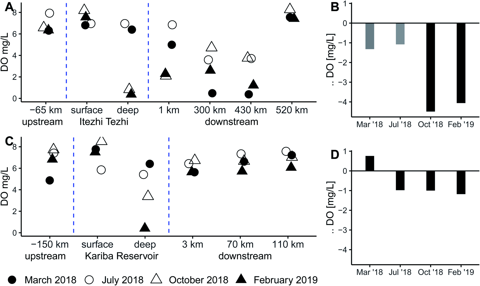 | ||
| Fig. 5 Seasonal dissolved oxygen concentration along the Zambezi (A) and Kafue (C) rivers and the differences between waters upstream and immediately downstream of Kariba Dam (B) and Itezhi-Tezhi Dam (D). | ||
At Kariba, as with temperature, the depth of the turbine intakes relative to the thermocline seems to buffer against extreme changes in dissolved oxygen reaching downstream waters (Fig. 5B). Regardless of season and the strength of stratification we observed downstream oxygen saturation falling within a relatively narrow range of values. We note that these values are mostly lower than those we observed upstream in the Zambezi River above Victoria Falls, but they are still well above those we observed in the Kafue in the wake of Itezhi-Tezhi. From sampling points further downstream on the Zambezi, we observed a trend of recovery towards near-saturation, though models have suggest that full recovery of dissolved oxygen will only occur after 380 km at which point the river will have already reached the Cahora Bassa reservoir in Mozambique.30
The severe hypoxia in the Kafue River below the Itezhi-Tezhi appears to be a new phenomenon driven by a recent change in dam operation. Previously, the Itezhi-Tezhi had served as a supply reservoir for downstream generation at the Kafue Gorge (located at the far end of the Kafue Flats) and discharged lake surface waters through spill gates. When power-generating turbines were installed and commissioned in 2015, the dam began releasing hypolimnetic and hypoxic waters, which has changed the oxygen regime of the Kafue River downstream compared to previous observations in 2012 and 2013 (Fig. 6). It is noteworthy that the severity of hypoxia we observed is far worse than that predicted by models forecasting the impacts of power generation on oxygen dynamics at this site.20
 | ||
| Fig. 6 Dissolved oxygen dynamics above, below and within the Itzehi Tezhi Reservoir, observed in 2018/2019 (this study) and in 2012/2013.10 | ||
The biogeochemical and ecological implications of deoxygenated water being discharged into the Kafue Flats are not known. Hypoxia is a naturally occurring state within the Kafue Flats, but only emerges 200 to 250 km downstream of the dam where hypoxic water draining from the floodplains rejoins the main river channel.21 Although the complex spatiotemporal dynamics of oxygen have not been fully resolved, the logical assumption is that the most water will be reentering the river from hypoxic floodplains during peak discharge, which occurs predictably each year roughly from February to May. Our observations of dissolved oxygen as well as those of Teodoru et al. (2015) support this seasonal pattern, with more severe hypoxia evident during February and March, compared to July and October. In contrast, the seasonality of reservoir stratification, which drives the discharge of hypoxic waters below the Itezhi-Tezhi Dam, follows (and lags by a few months) peak air temperatures, manifesting most strongly from October to April. This means that reservoir-driven hypoxic effects on the Kafue River differ from those of the Kafue Floodplain in both space and timing, the former potentially active for roughly half the year and influencing ecological and biogeochemical processes hundreds of kilometers upstream and in the upper reaches of the floodplain. Hypoxia in the Kafue River below the Itezhi-Tezhi Dam was independently confirmed by other investigators in 2019.31
Although we found little evidence to suggest the presence of severe hypoxia below Kariba Dam on the Zambezi, we caution that changes in the limnology of Kariba Reservoir and/or hydropower operations could cause an abrupt shift, analogous to what we encounter at Itezhi-Tezhi. Stratification dynamics of Kariba Reservoir and operations at Kariba Dam together govern downstream water chemistry of the Zambezi. Our observations of relatively mild downstream hypoxia stem directly from the configuration of multiple turbine intakes straddling the predominant depth of the thermocline/oxycline, resulting in discharge downstream that reflects a mixture of deep and shallow water conditions. Changes to either dam operations or patterns of reservoir stratification could make downstream hypoxia more severe in the future.
Changing the depth of the water intakes for turbines in tropical hydropower reservoirs would shift the chemistry of downstream water temperature and oxygen conditions. Similar effects could be driven by hypothetical future changes to the reservoir limnology that might make the predominant depth of the thermocline shallower. If Kariba Reservoir were to become more turbid, for example from eutrophication, this would decrease the photic depth and reduce the depth of the oxic epilimnion, effectively shifting the balance of discharges toward deep anoxic water. Climate warming could also change stratification dynamics by disrupting seasonal re-mixing driven by cooler air temperatures and winds. Modeling the physical mixing, temperature and oxygen regimes in tropical reservoirs30 such as Kariba and Itezhzi-Tezhi could quantify the projected effects of climate warming and increased fertilizer loads on water quality in downstream river reaches.
Dams and sediment trapping
The issue of sediment trapping in dams is a prominent one that intersects with dam operability (reservoir infilling), river geomorphology and delta subsidence; topics which lie well outside the scope of this study. We analyze sediment trapping from a water quality perspective, considering how dams alter TSS concentrations just as we do for other physico-chemical parameters such as dissolved oxygen or temperature. Grab sampling only gives us a snap shot of conditions during the sampling day, so we are missing important dynamics associated with storms, but we find that this analysis still elucidates dominant seasonal-scale patterns.TSS data illustrates the potential for the trapping of fine sediments in both Kariba and Itezhi-Tezhi reservoirs (Fig. 7). In the Zambezi, TSS varies strongly throughout the year with much higher values characterizing the rainy season compared to the dry season. Regardless of season, we observed very low TSS concentrations (<4 mg L−1) below Kariba Dam. Further downstream on the Zambezi, TSS recovered to concentrations similar to upstream reference condition within roughly 100 km, probably from bank erosion, resuspension and contributions from tributaries.
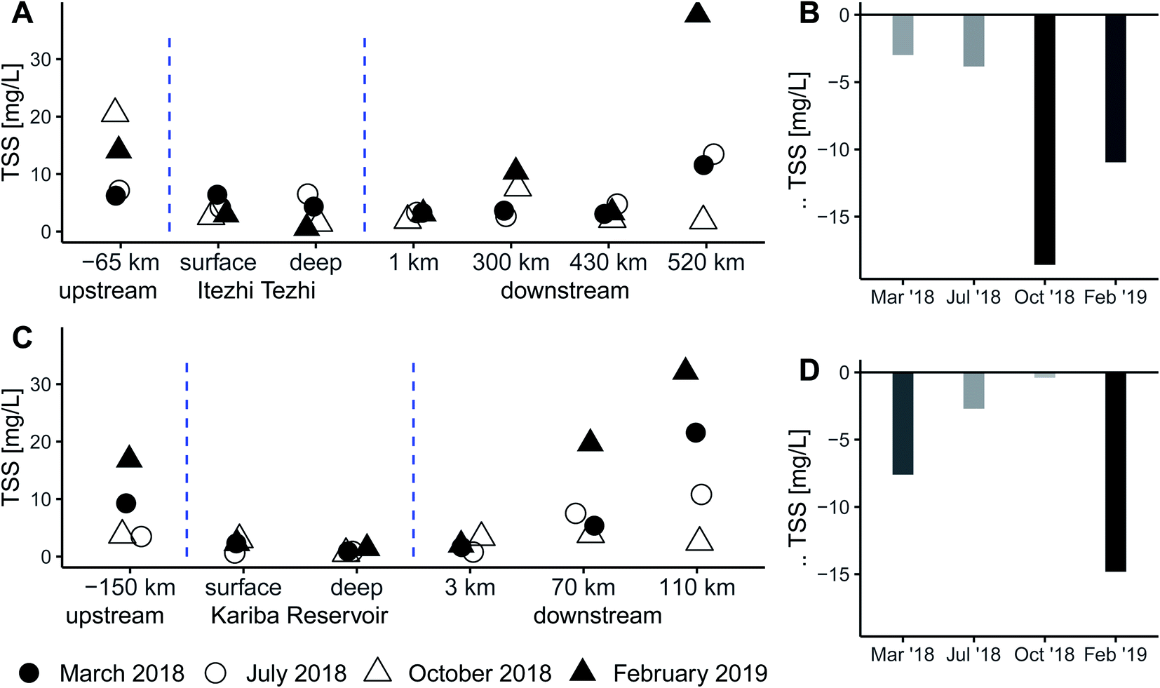 | ||
| Fig. 7 Seasonal total suspended solids concentration along the Zambezi (A) and Kafue (C) rivers and the differences between waters upstream and immediately downstream of Kariba Dam (B) and Itezhi-Tezhi Dam (D). | ||
The Kafue River above the Itezhi-Tezhi Reservoir also showed strong seasonal variation in TSS. The high value for October 2018 reflects an early rainfall event of 36 mm in the upper Kafue catchment 3 to 4 days before the day we sampled (www.worldweatheronline.com), a first flush of the rainy season that mobilized a lot of sediment locally. Below the Itezhi-Tezhi dam, TSS was lower than upstream for all sampling dates and at this location percent particulate carbon was very high, indicating the particulate matter was primarily microbial biomass inherited from the reservoir. Below the Kafue Flats, TSS levels had recovered to levels similar to those we observed upstream of the Itezhi-Tezhi Dam.
The direct effect of reducing particle load on water quality is increased transparency which will facilitate in-stream production downstream of dams. Sediment trapping by dams is a globally ubiquitous phenomenon with important indirect consequences for downstream ecosystems caused by changing river morphology and delta subsidence.32 In the Zambezi River Basin, little is known about dam-sediment effects beyond associated changes in long-term river geomorphology.33,34 Sediment starvation35 and a variety of potential mechanisms36 are likely to have impacts on downstream ecosystems, such as the Kafue Flats floodplain below the Itezhi-Tezhi Dam, the Mana Pools wetlands below Kariba Dam as well as the Zambezi Delta.37 Sediment management is an important component of dam design and planning, but because of uncertainty surrounding ecological impacts, prohibitive costs or other reasons,36 loss of river sediment transport, remains a major concern associated with hydropower expansion.38
Land-use change and water quality
Major research efforts have assessed the critical accumulation of phosphorus and nitrogen in agricultural soils and its impact on nutrient transfer along the aquatic continuums,39,40 not to mention centuries of investigation into wastewater treatment from cities. Regions of the Global South with limited fertilizer input and low population density, however, require a more targeted approach in order to assess watersheds at risk. We find that hotspots of nutrient and solute concentrations associated with selected small tributaries in the Zambezi River Basin reflect their relatively high degree of catchment land cover transformation. In general, the Kafue and the upper Zambezi are sparsely populated with a small percentage of urban or agricultural coverage, a fact reflected by the dilute solute concentrations we observed in the main stem surface water. In contrast, the Maramba and Chongwe sub-catchments contain several times more relative urban cover, and the Chongwe and Little Chongwe catchments contain much more relative agricultural cover. For a variety of water quality parameters, these three catchments showed elevated concentrations suggesting that agricultural and urban land cover additively contribute to deterioration of water quality. A linear model including both urban or crop land cover metrics explained specific conductivity and digestible phosphorus better than either land cover type alone (Fig. 8A–F). We found digestible nitrogen to be better explained by crop cover alone (Fig. 8H), with urban cover being a rather poor predictor (Fig. 8G) even when combined with cropland (Fig. 8I). Based on the regression coefficients, for each 10% increase in effective crop cover, we expect specific conductivity to increase by 75 ± 9 μS cm−1 (p = 0.002), digestible phosphorus to increase by 1.3 ± 0.4 mg L−1 (p = 0.009) and digestible nitrogen to increase by 10 ± 2.3 mg L−1 (p < 0.001) during the rainy season. For each 10% increase in effective urban cover, we expect specific conductivity to increase by 5.2 ± 1.4 μS cm−1 (p < 0.001), digestible phosphorus to increase by 0.3 ± 0.1 mg L−1 (p = 0.004) and digestible nitrogen to increase by 6.7 ± 3.5 mg L−1 (p = 0.078) during the rainy season. Of course, given the small sample size and numerous uncontrolled and potentially confounding variables, these relationships are tentative. Nevertheless, these calculations give a first estimate of the sensitivity of waterways in central and southern Zambia to land use change. Secondarily, we compared these same three parameters in the small impacted catchments, to small catchments draining mostly-forested protected areas and found that, as expected, the concentrations in the Maramba, Chongwe and Little Chongwe were much higher (Table S1; Fig. S2†). This result supports the notion that changes in these parameters are not simply a function of catchment size or local geology, but reflect patterns of land use.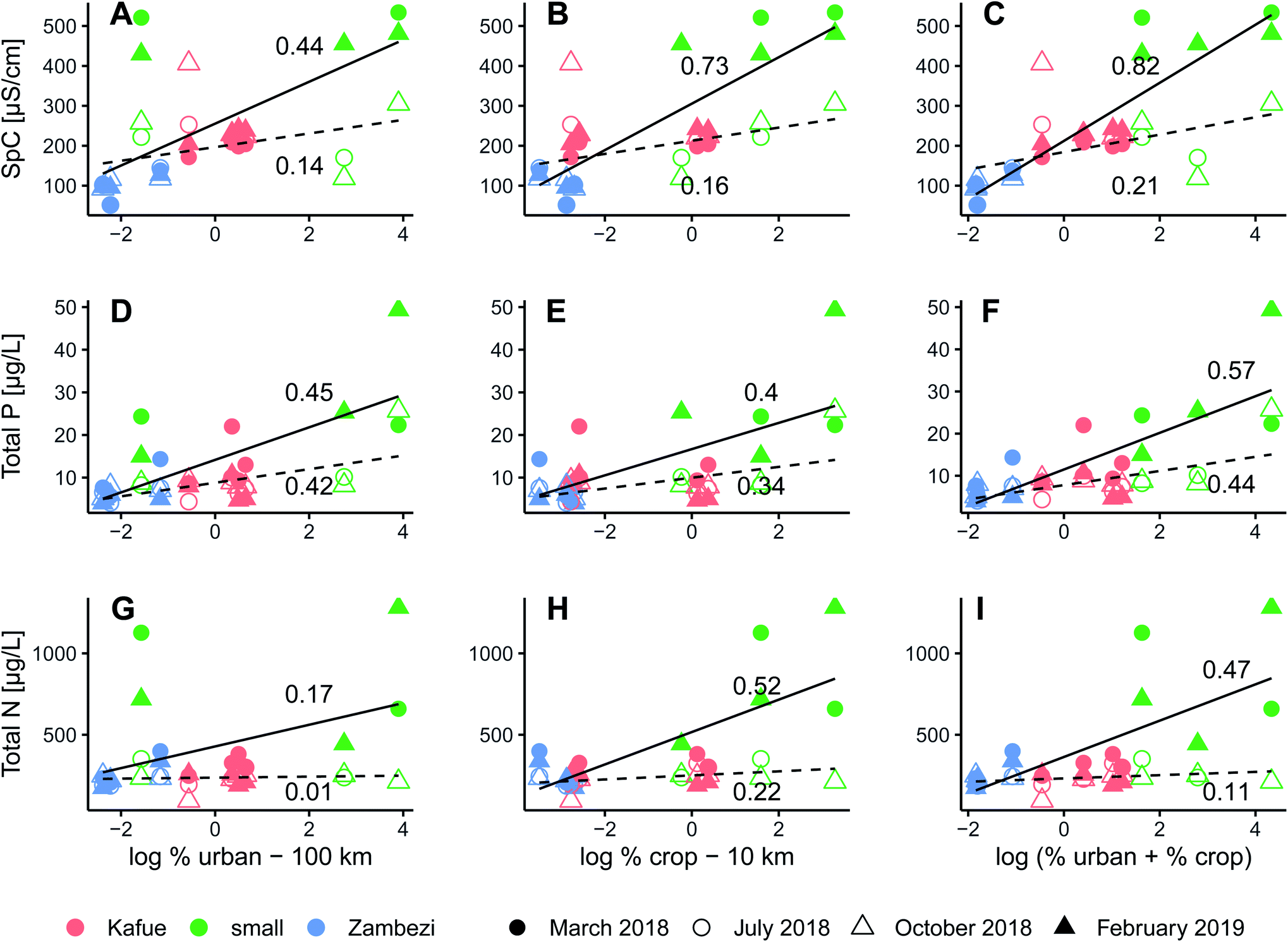 | ||
| Fig. 8 Relationships between select water quality parameters: specific conductivity (A–C), digestible phosphorus (D–F) and digestible nitrogen (G–I); and relative, distance-weighted anthropogenic landcover: urban cover (A, D, G), crop cover (B, E, H) and sum (C, F, I). Regression lines are calculated separately for wet season (solid) and dry season (dashed) data and overlaid numbers are r2 values. | ||
Demographers predict that the Zambian population will grow rapidly by 2050 and its urban population will more than triple from 7.7 million to 25.6 million.1 It is reasonable to expect that urban landcover and associated wastewater discharge will increase proportionally to accelerating urbanization. Based on the projected population growth, our regression models suggest that we should not necessarily expect major changes in concentrations of nutrients and solutes in the largest rivers because of their large dilution capacity. Smaller tributaries draining smaller sub-catchments may exhibit more severe increases in concentrations unless mitigated by investment in wastewater treatment infrastructure.
The future expansion of agriculture is difficult to predict, but there are two potential approaches. One would be to assume that growth in agricultural productivity will need to at least increase proportional to population growth to support domestic consumption. With globalized markets, however, Zambia may seek to increase its agricultural output in excess of population growth in order to generate exports; economists have suggested that agricultural development would be a prudent strategic goal.41 The population growth factor (3.3-fold increase by 2050) is probably a conservative lower bound for the rate of agricultural growth and its associated impacts of water quality (i.e. fertilizer and pesticide application, tilling). Another approach would be to predict exploitation of economically viable irrigation capacity, which should correlate strongly with both fertilizer use and total cropland cover. Irrigated land in Zambia already tripled from 50![[thin space (1/6-em)]](https://www.rsc.org/images/entities/char_2009.gif) 000 ha in 2002 (ref. 42) to 160000 ha in 2015 (ref. 43) and according to estimates, there is potential for another tripling in the future with an estimated ceiling of 520000 ha as a theoretical maximum.42 Therefore, a growth factor in agricultural expansion matching population seems realistic and may even be an underestimation as some researchers have argued that future irrigation use is systematically underestimated on a global scale.44
000 ha in 2002 (ref. 42) to 160000 ha in 2015 (ref. 43) and according to estimates, there is potential for another tripling in the future with an estimated ceiling of 520000 ha as a theoretical maximum.42 Therefore, a growth factor in agricultural expansion matching population seems realistic and may even be an underestimation as some researchers have argued that future irrigation use is systematically underestimated on a global scale.44
An increase by 3-fold (or more) of agricultural activity in Zambia might represent a more durable threat to water quality than the projected increase in urbanization. Unlike urban wastewater and other point sources, agricultural pollution is a diffusive source and typically more difficult to manage, though this depends greatly on the type of fertilizer used and the timing and magnitude of application. Mitigating non-point source pollution from agriculture requires a combination of management interventions ranging from the catchment to the field level.45 Improved farming practices include landscape engineering measures, improved crop management and site-specific adjustment of farming intensity.46 The establishment of riparian buffers and protection for wetlands are further recommended best-practices,47 but their establishment can be difficult without advanced planning and robust regulation.
Conclusion
The surface waters of Zambia largely exhibit excellent water quality except for smaller streams draining heavily impacted catchments which have elevated concentrations of solutes during wet seasons, and for the river reaches below large dams, which become seasonally hypoxic, exhibit altered thermal regimes and depletion in suspended sediments. As new dams are built, urban populations grow and agriculture expands and intensifies, there will likely be some additional degradation of water quality, but these will probably remain relatively localized for the foreseeable future. Nevertheless, since Zambia relies on river water for domestic use and on freshwater fisheries for a large share of its protein, it would be wise to monitor pollution hotspots closely for signs of further degradation so that timely mitigation measures can be implemented as necessary. These findings may be useful for managers looking to enhance water resources protection in other data-scare regions.Author contributions
| Contributor role | Role definition | |
|---|---|---|
| Conceptualization | Ideas; formulation or evolution of overarching research goals and aims | RSW, EC, CRT, BW |
| Methodology | Development or design of methodology; creation of models | RSW, EC, CRT, BW, FK |
| Investigation | Conducting a research and investigation process, specifically performing the experiments, or data/evidence collection | RSW, EC, CRT |
| Software | Programming, software development; designing computer programs; implementation of the computer code and supporting algorithms; testing of existing code components | RSW, FK |
| Data curation | Management activities to annotate (produce metadata), scrub data and maintain research data (including software code, where it is necessary for interpreting the data itself) for initial use and later reuse | RSW, EC, CRT |
| Formal analysis | Application of statistical, mathematical, computational, or other formal techniques to analyze or synthesize study data | RSW, FK |
| Visualization | Preparation, creation and/or presentation of the published work, specifically visualization/data presentation | RSW, FK |
| Validation | Verification, whether as a part of the activity or separate, of the overall replication/reproducibility of results/experiments and other research outputs | All |
| Funding acquisition | Acquisition of the financial support for the project leading to this publication | BW, IN |
| Project administration | Management and coordination responsibility for the research activity planning and execution | BW, IN, KB |
| Resources | Provision of study materials, reagents, materials, patients, laboratory samples, animals, instrumentation, computing resources, or other analysis tools | BW |
| Supervision | Oversight and leadership responsibility for the research activity planning and execution, including mentorship external to the core team | BW, IN, KB |
| Writing – original draft preparation | Creation and/or presentation of the published work, specifically writing the initial draft (including substantive translation) | RSW |
| Writing – review & editing | Preparation, creation and/or presentation of the published work by those from the original research group, specifically critical review, commentary or revision – including pre- or post-publication stages | All |
Conflicts of interest
There are no conflicts of interest to declare.Acknowledgements
This work was supported by the Decision Analytic Framework to explore the water-energy-food Nexus in complex transboundary water resource systems of fast developing countries (DAFNE) project, which has received funding from the European Union's Horizon 2020 research and innovation programme under grant agreement no. 690268. Patrick Kathriner (Eawag, Kastanienbaum) assisted with analysis of nutrients, ions, DOC and alkalinity. Daniel Steiner (Eawag, Kastanienbaum) performed chlorophyll analyses. Davide Vanzo (ETH Zurich) and Christian Dinkel (Eawag Kastanienbaum) provided companionship and assistance in the field. We conducted the field work with cooperation from the Zambia Water Resources Management Authority (WARMA). Felix Kabompo of WARMA and Annie Kalusa of the University of Zambia Integrated Water Resources Management Centre assisted with field sampling at reference sites. We thank Maurice Diamond (Lake Safari Lodge, Siavonga) for providing access to the sampling location below Kariba Dam and for use of boats for sampling the Kariba Reservoir. We also thank the friendly people at Gwabi Lodge, Breezers Lodge, Mukambi Lodge, Mama Out of Africa Lodge and Muchichili Lodge for helping with our data collection efforts.References
- United Nations, World population prospects 2019: Highlights, United Nations Publications, UN, 2019 Search PubMed.
- Southern African Development Community, Souther African Research and Documentation Centre, United Nations Environment Programme, GRID-Arendal, Zambezi Watercourse Commission, Zambezi River Basin Atlas of the Changing Environment, Gabarone, Harare, Arendal, 2012.
- R. S. Winton, E. Calamita and B. Wehrli, Reviews and syntheses: Dams, water quality and tropical reservoir stratification, Biogeosciences, 2019, 16(8), 1657–1671 Search PubMed.
- T. Maavara, Q. Chen, K. Van Meter, L. E. Brown, J. Zhang and J. Ni, et al., River dam impacts on biogeochemical cycling, Nature Reviews Earth & Environment, 2020, 1, 103–116, DOI:10.1038/s43017-019-0019-0.
- P. Schwarzenbach, T. Egli, T. B. Hofstetter, U. V. Gunten and B. Wehrli, Global Water Pollution and Human Health, Annual Review of Environment and Resources, 2010, 35, 109–136 Search PubMed.
- M. Ndebele-Murisa, I. A. Kimirei, C. P. Mubaya and T. Bere, Ecological Changes in the Zambezi River Basin, ed. M. Ndebele-Murisa, I. A. Kimirei, C. P.Mubaya and T. Bere, Council for the Development of Social Science Research in Africa, Dakar, Senegal, 2020 Search PubMed.
- C. Zarfl, A. E. Lumsdon, J. Berlekamp, L. Tydecks and K. Tockner, A global boom in hydropower dam construction, Aquat. Sci., 2014, 77(1), 161–170 Search PubMed.
- B. Lehner, C. R. Liermann, C. Revenga, C. Vörömsmarty, B. Fekete and P. Crouzet, et al., High-resolution mapping of the world's reservoirs and dams for sustainable river-flow management, Frontiers in Ecology and the Environment, 2011, 9(9), 494–502 Search PubMed.
- United Nations Statistics Division, UN Data: a world of information, 2020, available from: http://data.un.org/ Search PubMed.
- C. R. Teodoru, F. C. Nyoni, A. V. Borges, F. Darchambeau, I. Nyambe and S. Bouillon, Dynamics of greenhouse gases (CO2, CH4, N2O) along the Zambezi River and major tributaries, and their importance in the riverine carbon budget, Biogeosciences, 2015, 12(8), 2431–2453 Search PubMed.
- M. J. Kunz, A. Wüest, B. Wehrli, J. Landert and D. B. Senn, Impact of a large tropical reservoir on riverine transport of sediment, carbon, and nutrients to downstream wetlands, Water Resources Research, 2011, 47(12), 1–16, DOI:10.1029/2011WR010996.
- R. Beilfuss. A Risky Climate for Southern African Hydro. Int Rivers, Berkely, 2012, pp. 1–46, available from: http://climenews.com/letoltes/zambezi_climate_report_final.pdf Search PubMed.
- B. Lehner and G. Grill, Global river hydrography and network routing: Baseline data and new approaches to study the world's large river systems, Hydrol. Process, 2013, 27(15), 2171–2186 Search PubMed.
- M. Buchhorn, B. Smets, L. Bertels, M. Lesiv, N.-E. Tsendbazar and M. Herold, et al., Copernicus Global Land Service: Land Cover 100 m: epoch 2015: Globe. Zenodo, 2019 Search PubMed.
- J. Zhang, Current Wet Persulfate Digestion Method Considerably Underestimates Total Phosphorus Content in Natural Waters, Environ. Sci. Technol., 2012, 46, 13033–13034 Search PubMed.
- A. L. Liberoff, S. Flaherty, P. Hualde, M. I. García Asorey, M. L. Fogel and M. A. Pascual, Assessing land use and land cover in fl uence on surface water quality using a parametric weighted distance function, Limnologica, 2019, 74, 28–37 Search PubMed.
- R. J. Hijmans and J. van Etten, raster: Geographic analysis and modeling with raster data. 2012, available from: http://cran.r-project.org/package=raster Search PubMed.
- R Core Team. R, A language and environment for statistical computing, R Foundation for Statistical Computing, Vienna, 2019, available from: https://www.r-project.org/ Search PubMed.
- E. Calamita, M. Schmid, M. Kunz, M. R. Ndebele-murisa, C. H. D. Magadza and I. Nyambe, et al., Sixty years since the creation of Lake Kariba: Thermal and oxygen dynamics in the riverine and lacustrine sub-basins, PLoS One, 2019, 1–21 Search PubMed.
- M. J. Kunz, D. B. Senn, B. Wehrli, E. M. Mwelwa and A. Wüest, Optimizing turbine withdrawal from a tropical reservoir for improved water quality in downstream wetlands, Water Resources Research, 2013, 49(9), 5570–5584 Search PubMed.
- R. Zurbrügg, J. Wamulume, R. Kamanga, B. Wehrli and D. B. Senn, River-floodplain exchange and its effects on the fluvial oxygen regime in a large tropical river system (Kafue Flats, Zambia), J. Geophys. Res.: Biogeosci., 2012, 117(3), 1–12 Search PubMed.
- J. King, J. A. Cambray and N. D. Impson, Linked effects of dam-released floods and water temperature on spawning of the Clanwilliam yellowfish Barbus capensis, Hydrobiologia, 1998, 384, 245–265 Search PubMed.
- R. M. Preece and H. A. Jones, The effect of Keepit Dam on the temperature regime of the Namoi River, Australia, River Research and Applications, 2002, 18(4), 397–414 Search PubMed.
- T. J. Haxton and C. S. Findlay, Meta-analysis of the impacts of water management on aquatic communities, Canadian Journal of Fisheries and Aquatic Sciences, 2008, 65(3), 437–447 Search PubMed , available from: http://www.nrcresearchpress.com/doi/abs/10.1139/f07-175.
- A. M. Deines, C. A. Bee, C. Katongo, R. Jensen and D. M. Lodge, The potential trade-off between artisanal fisheries production and hydroelectricity generation on the Kafue River, Zambia, Freshwater Biology, 2013, 58, 640–654 Search PubMed.
- I. G. Cowx, A. Lungu and M. Kalonga, Optimising hydropower development and ecosystem services in the Kafue River, Zambia, Marine and Freshwater Research, 2018 Search PubMed.
- A. Zuijdgeest, S. Baumgartner and B. Wehrli, Hysteresis effects in organic matter turnover in a tropical floodplain during a flood cycle, Biogeochemistry, 2016, 1–15 Search PubMed.
- A. Zuijdgeest and B. Wehrli, Carbon and nutrient fluxes from floodplains and reservoirs in the Zambezi basin, Chem. Geol., 2017, 467, 1–11 Search PubMed.
- A. L. Zuijdgeest, R. Zurbrügg, N. Blank, R. Fulcri, D. B. Senn and B. Wehrli, Seasonal dynamics of carbon and nutrients from two contrasting tropical floodplain systems in the Zambezi River basin, Biogeosciences, 2015, 12(24), 7535–7547 Search PubMed.
- E. Calamita, D. Vanzo, B. Wehrli and M. Schmitd, Lake modelling reveals management opportunities for improving water quality downstream of transboundary tropical dams, Water Resour. Res., 2021 DOI:10.1029/2020WR027465.
- N. Muyumbana, Impact of the Itezhi-Tezhi reservoir on dissolved oxygen and greenhouse gas dynamics in the Kafue River, Zambia. IHE Delft Institute for Water Education, 2019 Search PubMed.
- C. J. Vörösmarty, M. Meybeck, B. Fekete, K. Sharma, P. Green and J. P. M. Syvitski, Anthropogenic sediment retention: Major global impact from registered river impoundments, Glob Planet Change, 2003, 39(1–2), 169–190 Search PubMed.
- O. Khan, E. Mwelwa-Mutekenya, A. Crosato and Y. Zhou, Effects of dam operation on downstream river morphology: the case of the middle Zambezi River, Proc. Inst. Civ. Eng.: Water Manag., 2014, 167(10), 585–600 Search PubMed.
- P. Ronco, G. Fasolato, M. Nones and G. Di Silvio, Morphological effects of damming on lower Zambezi River, Geomorphology, 2010, 115(1–2), 43–55, DOI:10.1016/j.geomorph.2009.09.029.
- G. M. Kondolf, Z. K. Rubin and J. T. Minear, Dams on the Mekong: Cumulative sediment starvation, Water Resources Research, 2014, 50(6), 5158–5169 Search PubMed.
- C. Hauer, B. Wagner, J. Aigner, P. Holzapfel, P. Flödl and M. Liedermann, et al., State of the art, shortcomings and future challenges for a sustainable sediment management in hydropower: A review, Renewable Sustainable Energy Rev., 2018, 98, 40–55, DOI:10.1016/j.rser.2018.08.031.
- B. R. Davies, R. D. Beilfuss and M. C. Thoms, Cahora Bassa retrospective, 1974-1997: effects of flow regulation on the lower Zambezi River, Verhandlungen des Int Verein Limnol., 2001, 27(4), 2149–2157 Search PubMed.
- G. M. Kondolf, Y. Gao, G. W. Annandale, G. L. Morris, E. Jiang and J. Zhang, et al., Sustainable sediment management in reservoirs and regulated rivers: Experiences from five continents, Earth's Futur, 2014, 2(5), 256–280, DOI:10.1002/2013EF000184.
- A. F. Bouwman, A. H. W. Beusen and G. Billen, Human alteration of the global nitrogen and phosphorus soil balances for the period 1970-2050, Global Biogeochem. Cycles, 2009, 23(4) DOI:10.1029/2009GB003576.
- S. P. Seitzinger, E. Mayorga, A. F. Bouwman, C. Kroeze, A. H. W. Beusen and G. Billen, et al., Global river nutrient export: A scenario analysis of past and future trends, Global Biogeochem. Cycles, 2010, 24(2) DOI:10.1029/2009GB003587.
- J. Phiri, K. Malec, S. K. Majune, M. Maitah and K. Maitah, Agriculture as a Determinant of Zambian Economic Sustainability, Sutainability, 2020, 12, 4459 Search PubMed.
- K. Frenken, Irrigation in Africa: AQUASTAT Survey - 2005, FAO Land and Water Developmet Division, Rome, 2005, p. 649 Search PubMed.
- I. M. Akayombokwa, B. Van Koppen and M. Matete, Trends and Outlook: Agricultural Water Management in Southern Africa: Country Report Zambia, 2015, available from: https://www.agrilinks.org/sites/default/files/resource/files/IWMI%20Synthesis%20report%20agwater%20management%20in%20SADC.pdf Search PubMed.
- A. Puy, S. Lo Piano and A. Saltelli, Current Models Underestimate Future Irrigated Areas, Geophys. Res. Lett., 2020, 47(8), 1–10 Search PubMed.
- O. F. Schoumans, W. J. Chardon, M. E. Bechmann, C. Gascuel-odoux, G. Hofman and B. Kronvang, et al., Science of the Total Environment Mitigation options to reduce phosphorus losses from the agricultural sector and improve surface water quality: A review, Sci. Total Environ., 2014, 468–469, 1255–1266, DOI:10.1016/j.scitotenv.2013.08.061.
- A. R. Melland, O. Fenton and P. Jordan, Effects of agricultural land management changes on surface water quality: A review of meso-scale catchment research, Environ. Sci. Policy, 2018, 84 DOI:10.1016/j.envsci.2018.02.011.
- J. D. Phillips, Nonpoint source pollution control effectiveness of riparian forests along a coastal plain river, J. Hydrol, 1989, 110(3–4), 221–237 Search PubMed.
Footnote |
| † Electronic supplementary information (ESI) available. See DOI: 10.1039/d1em00006c |
| This journal is © The Royal Society of Chemistry 2021 |