
 Open Access Article
 This Open Access Article is licensed under a Creative Commons Attribution-Non Commercial 3.0 Unported Licence
Natural greenhouse gas and ozone-depleting substance sources and sinks from the peat bogs of Connemara, Ireland from 1994–2020
Richard G.
Derwent
a,
Peter G.
Simmonds
*b,
Simon J.
O'Doherty
b,
T. Gerard
Spain
c and
D.
Young
b
aRdscientific, Newbury, Berkshire RG14 6LH, UK
bSchool of Chemistry, University of Bristol, Bristol, BS8 1TS, UK. E-mail: petergsimmonds@aol.com
cSchool of Physics, National University of Ireland-Galway, Galway, H91 TK33, Ireland
First published on 24th July 2021
Abstract
The peat bogs of Connemara in the vicinity of the Mace Head Atmospheric Research Station on the Atlantic Ocean coastline of Ireland act as natural sources and sinks of greenhouse gases and ozone-depleting substances. Simultaneous emissions of methane and chloroform occur routinely during night-time inversions and low wind speeds, with concurrent depositions of ozone and hydrogen. The temporally correlated ozone data were employed with the nocturnal box method to determine the deposition velocities of hydrogen and the emission rates of methane and chloroform during 502 night-time events over the study period from 1994–2020. The average hydrogen deposition velocity found was 0.45 ± 0.3 mm s−1. Hydrogen deposition velocities appeared to increase with time by about +1.2% per year. Chloroform emission rates averaged 0.44 ng m−2 s−1 and were somewhat smaller than those we have reported previously. Methane emission rates averaged 0.37 ± 0.2 μg m−2 s−1 in agreement with our previous studies but this study found an increase with time of +1.3% per year which was statistically significant. This increase was probably driven by local climate change through the increasing rainfall seen during the study period.
Environmental significanceMethane and ozone are the second and third most important man-made greenhouse gases after carbon dioxide and chloroform is the second most important natural chlorine carrier to the stratosphere after methyl chloride. It is important to understand their natural as well as man-made sources and their removal processes from the atmosphere. The Connemara peat bogs surrounding the Mace Head Atmospheric Research Station exert a local influence on the night-time measurements of methane, ozone and chloroform and this allows a quantification of local natural sources and sinks. In addition, our observations have allowed the quantification of the deposition rate of hydrogen. Hydrogen is a little studied trace gas that may play an important role in future zero-carbon energy systems. However, it is an indirect greenhouse gas by virtue of its impact on the tropospheric hydroxyl radical distribution and the global distributions of methane and ozone. Hydrogen deposition is a key process in mitigating this indirect global warming and measurements of hydrogen deposition are required because it is poorly defined. |
1. Introduction
Methane (CH4) is the second most important man-made greenhouse gas after carbon dioxide (CO2)1 and has both natural and man-made sources. Its global atmospheric levels have been rising rapidly in recent years and there are concerns that this may be driven by increasing biological sources of CH4 such as wetlands, thawing permafrost, or livestock.2 There is therefore an interest in the trends over recent years in CH4 sources, both natural and man-made and CH4 sinks.3,4 Natural sources of CH4 include wetlands and peatlands in the tropics and mid-to-high latitudes,5 tundra and enteric fermentation in animals. Peatlands are the largest natural source of atmospheric CH4 and climatic changes in soil temperature and precipitation are expected to favour CH4 production, thereby increasing CH4 emissions. Furthermore, these processes are regulated by variations in the water table where net CH4 emissions depend on the history of inundation.6 This study addresses one of these natural CH4 sources, namely the lowland peat bogs of Connemara on the west coast of Ireland. We examine the trends in CH4 emissions over the last 25 years by extending our previous study.7Peat bogs have important roles in biogeochemical cycles, besides acting as natural CH4 sources they are significant contributors to the global carbon cycle. In addition to emitting CH4, they also emit halocarbons such as chloroform (CHCl3).8–10 CHCl3 is the second-most important natural chlorine carrier to the stratosphere.11 Previous studies on the coastal peat bogs of Ireland confirmed their importance as natural CHCl3 sources.10 The trends with time of the simultaneous natural sources of CH4 and CHCl3 should provide a useful check on the influence, if any, of climate change on biogeochemical cycling in the Connemara peat bog ecosystems.
As the policy focus shifts away from supporting fossil fuel use to promoting low- or zero-carbon energy systems, much attention is being given to understanding the potential future role of hydrogen (H2).12 Although H2 is not itself a direct greenhouse gas, it acts as an indirect greenhouse gas because its atmospheric emissions reduce the oxidation capacity of the atmosphere, leading to increased methane levels and exacerbate the global warming from CH4 and ozone (O3), the second and third most important man-made greenhouse gases after carbon dioxide.13 Methane oxidation is a major source of tropospheric ozone hence increasing methane levels lead to increasing ozone levels.13 Key to the assessment of the indirect global warming consequences of atmospheric H2 emissions is the biogeochemical life cycle of H2 and, in particular, its surface uptake by deposition.14 Deposition to land surfaces is the most important removal process for H2 and causes the observed latitudinal concentration profile in which southern hemisphere concentrations are higher than those in the northern hemisphere, despite large man-made emission sources in the northern hemisphere.15 The Connemara peat bogs act as a H2 deposition sink and we report one of the few long-term global records of H2 deposition to a peat bog ecosystem.
2. Methods
2.1 Mace Head atmospheric research station
The Mace Head atmospheric research station is in the west of Ireland on the North Atlantic coast (53.327N, 9.904W, 8 m asl). The site encounters a wide range of airmass types, predominantly maritime but on occasion, continental. The nominal clean sector is defined as 180° to 300° and wind speed above 4 m s−1. Analysis of local meteorological data indicates that air masses arrive within the clean sector approximately 50% of the time. The variety of airmass types encountered is advantageous in that it facilitates the study of very different atmospheric regimes.The immediate region around the site is classified as Atlantic blanket bog.16,17 The boggy soil is shallow with granite outcrops and small lakes. The vegetation is typical of this land type including, heathers, sedges, rushes, moor grass and gorse.18,19Fig. 1 presents a sketch map of the area surrounding the Mace Head station showing the location of the peat bogs, downloaded from https://gis.epa.ie/EPAMaps/.
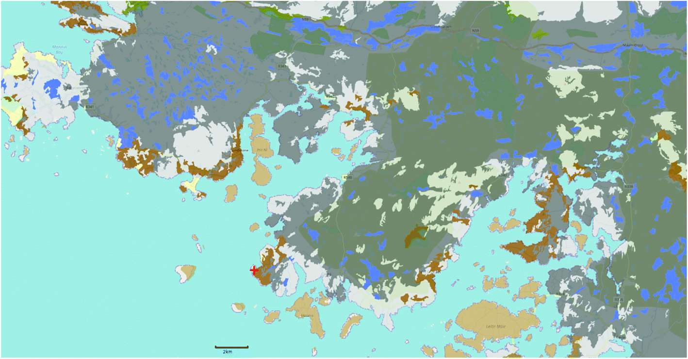 | ||
| Fig. 1 Sketch map showing the location of the Mace Head, Ireland station (red cross) in relation to the surrounding peat bogs in Connemara extracted from the website: https://gis.epa.ie/EPAMaps/. The darker brown and grey shades indicate peat which covers approximately 3000 km2 in the Connemara region. | ||
There is no significant industrial activity in the region with small scale fish farming and inshore fishing predominating. Agricultural activity is generally limited to low intensity grazing of cattle and there is little or no tillage. The nearest major urban centre is Galway city ∼65 km to the east which has a population of ∼80![[thin space (1/6-em)]](https://www.rsc.org/images/entities/char_2009.gif) 000.20
000.20
2.2 Trace gas measurements
Methane (CH4), hydrogen (H2) and chloroform (trichloromethane, CHCl3) measurements were made by injecting air samples into a fully automated, multi-column chromatographic system (AGAGE-MD) and directed to a variety of detectors. CH4 was detected using a flame ionisation detector, H2 a reduction gas analyser (RGA3) and CHCl3 an electron capture detector.13,21,22The analysis sequence consisted of an air sample followed by a standard to determine and correct for instrumental drift, resulting in 36 fully calibrated air samples per day. Each sample was dried prior to separation using a permeation Nafion drier (Permapure, USA). All measured dry mole fractions were determined relative to a working standard that had been calibrated using internationally recognised calibration scales, TU1987 for CH4,23 MPI-2009 for H224 and SIO-98 for CHCl3.23
O3 measurements were acquired with commercial UV spectrometers, utilising three separate analysers over the period of this investigation. The instruments were Model ML8810 (Monitor Labs San Diego, CA) from April 1987 to March 2003. Models 49C and 49i (Thermo Electron Inc., Franklin, MA) were used from March 2003 to April 2016 and April 2016 to date, respectively. The instruments were operated within the UK Rural O3 Network, latterly the Automatic Urban Rural Network (AURN). As part of the quality control used in that network, their calibration was audited 2–4 times annually against a National Physical Laboratory-traceable UV photometer transfer standard.25 Additional audits by the Irish Environmental Protection Agency and the World Calibration Centre for O3 provide independent verification of the measurement quality.26,27 Measurements were recorded as hourly averages from 1978–1995; post-1995 measurements were recorded as 1 min averages and after filtering to remove invalid data, averaged to one hour. Data are transmitted in near real-time to the AURN network (https://uk-air,defra.gov.uk/data/) and the Irish EPA (https://www.epa.ie/air/quality/data/mh/gas/). After validation the data are submitted to both of the above agencies and the Global Atmospheric Watch (GAW) World Data Centre for reactive gases (WDCRG) (https://www.gaw-wderg.org/). Further details on the experimental set-up can be found in ref. 28.
2.3 The nocturnal box model
In previous studies, we have reported the occurrence of local, natural trace gas sources and sinks during night-times under low windspeed and near-calm conditions at the Mace Head Atmospheric Research Station. Under these conditions, O3 and H2 mixing ratios may drop from their baseline levels over the period of several hours29 and CH47 and CHCl310 mixing ratios may rise. This behaviour is caused by natural sources and sinks involving the peat bogs of Connemara in the vicinity of the Mace Head station.
During low windspeed and near-calm conditions during the early evening, temperature inversions may form close to the ground. Whilst turbulent dispersion continues close to the ground, it is suppressed by the nocturnal inversion at greater heights. O3 and H2 levels become depleted relative to the levels aloft as they are taken up by surface deposition below the nocturnal inversion and cannot be replenished because of the suppression of vertical mixing. In contrast, CH4 and CHCl3 accumulate below the nocturnal inversion relative to the levels aloft because they have surface sources across the Connemara peat bogs. After sunrise on the following morning, the nocturnal inversion breaks up and vertical mixing replenishes the O3 and H2 levels close to the surface and disperses the higher CH4 and H2 concentrations through mixing with the lower background levels aloft. In this way, the night-time O3 and H2 depletions and the CH4 and CHCl3 enhancements are dissipated. Sometimes, however, even at night, the night-time calm conditions break down and a burst of wind breaks up the inversion and O3 and H2 levels are replenished and CH4 and CHCl3 return to baseline levels. Under these conditions, our analysis is terminated for that night, irrespective of whether the nocturnal inversion reforms or not.
These phenomena are illustrated in Fig. 2a–c which present an extract from the Mace Head trace gas records covering the period of June 15th–30th, 2014. Fig. 2a presents the simultaneous records of O3 and H2. Baseline O3 levels at this time were close to 30 ppb and those of H2, close to 540 ppb. Four events of calm conditions are marked on the plots occurring on the nights of 18th–19th, 24th–25th, 26th–27th and 28th–29th June 2014.
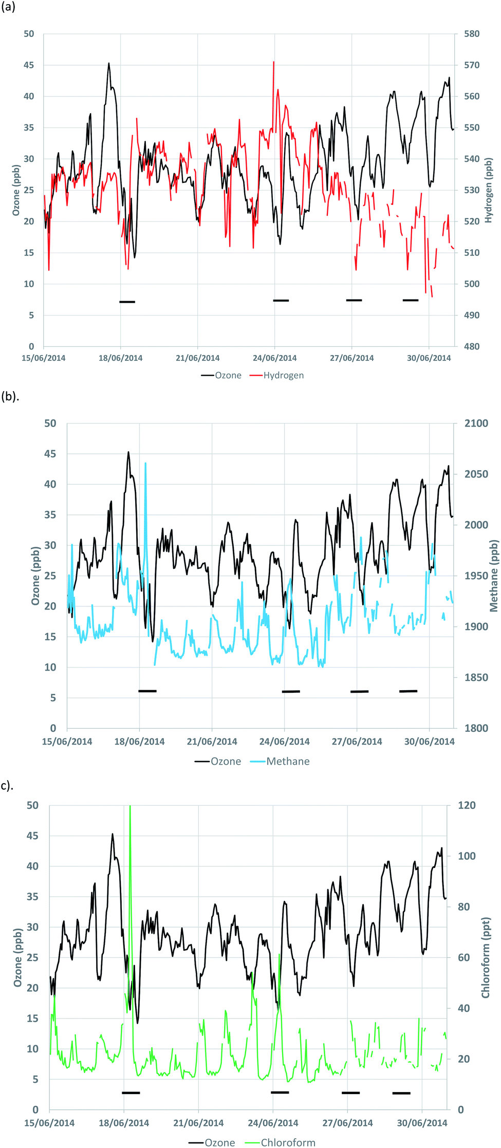 | ||
| Fig. 2 (a–c) Simultaneous time development of the ozone mixing ratios with (a) hydrogen, (b) methane and (c) chloroform over a fifteen-day period from 15th June to 30th June 2014. Black bars indicate four specific events discussed in the text. | ||
During the first event, O3 levels halved to about 15 ppb, whilst H2 levels declined by about 5% to 510 ppb over the period of a few hours. During this same event, CH4 levels increased by about 10% from a baseline level of about 1900 ppb to 2060 ppb, see Fig. 2b. At the same time, CHCl3 levels increased 8-fold, peaking at about 120 ppb from a baseline levels of about 15 ppb, see Fig. 2c. During the second event, the O3 and H2 depletions are clearly evident but the CH4 and CHCl3 emissions are smaller than in the first event. The O3 and H2 depletions and CH4 and CHCl3 enhancements are all evident in the third event. However, the methane peak is hardly evident during the fourth event. These differences in trace gas behaviour between the four events reinforces the inherent variability seen in trace gas sources and sinks over the fifteen-day period and in the complete record.
Under the conditions where a nocturnal inversion forms in the lower atmosphere, we can assume that a box is formed with its base on the surface of the peat bog and its lid at the level of the nocturnal inversion at some height, h, above which further vertical dispersion is inhibited. Assuming the contents of the box are well-mixed, then the time dependence of the mixing ratio of a depositing trace gas, c, below the inversion can be represented by:
| dc/dt = D/h = −vc/h |
| (1/ci × vi)dci/dt = (1/cj × vj)dc × /dt = 1/h | (1) |
For a trace gas, k, that is being continuously emitted from the peat bog with an area emission source strength of Ek in μg m−2 s−1 under the nocturnal inversion, then its time rate of change of concentration, dck/dt, is given by:
| dck/dt = Ek/h |
| dck/dt = E(1/vc)dc/dt. | (2) |
Hence, the trace gas emission rate per unit area per unit time, Ek, can be estimated from the rate of growth of the trace gas concentration, dck/dt, and the simultaneous fractional decline in the concentration of the reference trace gas, 1/ci × dci/dt. Further details of the nocturnal box model method for determining trace gas fluxes in terrestrial and aquatic systems are given in ref. 30.
3. Analysis of the Mace Head trace gas record
The hourly O3 observations and the 40 minute AGAGE CH4, H2 and CHCl3 observations were merged into a single database with a common hourly time-base. The composite dataset contained 232513 entries, covering the 27 year period from 20:00 h on 17th February 1994 to 11:00 h on 30th December 2020, representing a data capture of 98.7%. This database was searched for any hourly O3 record corresponding to times of 18:00, 19:00, 20:00 or 21:00 h with five consecutive hourly O3 records with monotonically decreasing O3 mixing ratios. The search was thus looking for six-hourly time periods of continuously decreasing O3 mixing ratios starting from 18:00 h. A total of 1622 six-hourly nocturnal depletion events, between 18:00 and 21:00 h onwards, were found during the 27 year study period. This search excluded events where a nocturnal inversion reformed after the initial nocturnal inversion had been eroded so that only one event was studied during each night. Nocturnal depletion events starting after 22:00 h were interrupted by such erosions and so were excluded from the initial search.
Each of the 1622 six-hour nocturnal depletion events was then selected and the simultaneous behaviour of H2, CH4 and CHCl3 was investigated. Evidence was found for simultaneous declines in O3 and H2 and increases in CH4 and CHCl3 in 502 out of the 1622 events. Nocturnal inversion events involving all four trace gases were identified on 502 out of 9814 nights, that is on 5% of all nights, during the 27 year study period. Events were rejected if simultaneous declines in O3 and H2 or emissions of CH4 or CHCl3 were not detected. There are several reasons why this is important, for example, declines in O3 due to southerly transport were easily identified and rejected due to the simultaneous increase in H2 mixing ratio due to its inverted latitudinal gradient. For each of the 502 events, the H2 deposition velocity and the area emission rates of CH4 and CHCl3 could be estimated using expressions (1) and (2), if the deposition velocity for the reference trace gas, O3, vi, was known.
In applying the nocturnal box model to the Mace Head data and the Connemara peat bog, attention has necessarily been directed to the 18:00–06:00 h period when deposition to land surfaces is least active and is controlled by the non-stomatal resistance process.31–33 Diurnal, seasonal and long-term variability have been reported in the non-stomatal resistance of O3 depositing to a blanket peat bog at Auchencorth Moss in Scotland, where the average nocturnal deposition from 1995–1998 was reported to be 2 mm s−1.34 However, a more complete analysis of the non-stomatal resistance to O3 deposition recommends 2.6 ± 0.2 mm s−1 under the wet conditions appropriate to the Connemara peat bog, with little or no temperature sensitivity over the ambient 5–30 °C temperature range.35 El-Madany et al.,36 performed a careful study of daytime non-stomatal O3 uptake to the Mittleres Wietingsmoor in north-west Germany. However, to our knowledge the only study of night-time non-stomatal uptake to peat bogs remains the Coyle et al., study,35 with large uncertainties.
Non-stomatal O3 deposition has been treated historically as a constant, however O3 deposition varies with radiation, temperature, and surface water.34 Under nocturnal conditions radiation is not relevant and diurnal temperature is likely to be minimal and stable, leaving precipitation as the most important factor affecting O3 deposition. A major limitation of this present study is the lack of any observations of temperature, humidity and other environmental conditions for the Connemara peat bog and the resistances to O3 deposition and their interannual variability. In the absence of these local data, we assume 2.6 ± 0.2 mm s−1 for vi, which is appropriate for the biome of this study.
Taking a value of 2.6 ± 0.2 mm s−1 for vi, 502 values of the deposition velocity for H2 and the emission fluxes of CH4 and CHCl3 have been estimated from their time rates of change. Averaging over the entire study period, the mean H2 deposition velocity was found to be 0.45 mm s−1 (s.d. ± 0.3 mm s−1) which is significantly lower by 15% compared to our previous value of 0.53 mm s−1 (s.d. ± 0.16 mm s−1),29 though well within the combined uncertainty range of both studies. The mean CH4 emission flux was found to be 0.37 μg m−2 s−1 (s.d. ± 0.2 μg m−2 s−1). This mean CH4 emission flux compares well with the 0.33 μg m−2 s−1 (s.d. ± 0.07 μg m−2 s−1)7 reported previously for the shorter twelve-year period and is well within the combined uncertainty range for both studies. The mean CHCl3 emission flux was found to be 0.44 ng m−2 s−1 (s.d. ± 0.1 ng m−2 s−1) which is much lower than our previously reported value of 0.81 ng m−2 s−1 (s.d. ± 0.6 ng m−2 s−1).10 However, the difference between these results, +0.37 ± 0.6 ng m−2 s−1 is not statistically significantly different from zero, showing that there is no statistical difference between the two datasets, reflecting the huge temporal variability in the CHCl3 emission flux determinations.
The 502 nocturnal inversion events were sorted into years between 1994 and 2020 and the annual summaries were prepared as shown in Table 1. The number of nocturnal inversion events in which O3 and H2 displayed evidence of concurrent nocturnal depletion and simultaneous CH4 and CHCl3 emission has increased steadily from around 10 per year at the start of the study period to over 20 per year at the end as shown in Fig. 3 (black triangles). This increase was highly statistically significant at the 99.9% level of confidence, according to the Mann-Kendall test.37 The annual mean values of the H2 deposition velocity increased from around 0.3 mm s−1, see Fig. 3, to just under 0.5 mm s−1. This increase of +1.2% per year was statistically significant at the 90% level of confidence, according to the Mann-Kendall test.37
| Year | Number of events | H2 deposition velocity, mm s−1 | CH4 emission flux, μg m−2 s−1 | CHCl3 emission flux, ng m−2 s−1 |
|---|---|---|---|---|
| 1994 | 7 | 0.27 ± 0.16 | 0.37 ± 0.16 | 0.44 ± 0.17 |
| 1995 | 7 | 0.34 ± 0.20 | 0.20 ± 0.08 | 0.33 ± 0.20 |
| 1996 | 10 | 0.34 ± 0.16 | 0.19 ± 0.12 | 0.45 ± 0.34 |
| 1997 | 10 | 0.33 ± 0.15 | 0.31 ± 0.19 | 0.22 ± 0.13 |
| 1998 | 22 | 0.38 ± 0.24 | 0.29 ± 0.23 | 0.40 ± 0.28 |
| 1999 | 15 | 0.32 ± 0.32 | 0.36 ± 0.22 | 0.40 ± 0.17 |
| 2000 | 24 | 0.43 ± 0.40 | 0.52 ± 0.32 | 0.41 ± 0.26 |
| 2001 | 17 | 0.53 ± 0.61 | 0.39 ± 0.23 | 0.48 ± 0.37 |
| 2002 | 12 | 0.47 ± 0.23 | 0.30 ± 0.15 | 0.32 ± 0.19 |
| 2003 | 10 | 0.41 ± 0.24 | 0.43 ± 0.17 | 0.39 ± 0.17 |
| 2004 | 16 | 0.47 ± 0.25 | 0.23 ± 0.09 | 0.41 ± 0.29 |
| 2005 | 23 | 0.55 ± 0.42 | 0.38 ± 0.31 | 0.32 ± 0.20 |
| 2006 | 12 | 0.46 ± 0.36 | 0.46 ± 0.27 | 0.42 ± 0.42 |
| 2007 | 14 | 0.33 ± 0.22 | 0.40 ± 0.20 | 0.48 ± 0.36 |
| 2008 | 23 | 0.44 ± 0.42 | 0.37 ± 0.18 | 0.45 ± 0.31 |
| 2009 | 15 | 0.48 ± 0.31 | 0.47 ± 0.27 | 0.44 ± 0.26 |
| 2010 | 19 | 0.49 ± 0.59 | 0.38 ± 0.20 | 0.35 ± 0.30 |
| 2011 | 13 | 0.75 ± 0.46 | 0.38 ± 0.23 | 0.38 ± 0.16 |
| 2012 | 24 | 0.54 ± 0.39 | 0.37 ± 0.25 | 0.38 ± 0.27 |
| 2013 | 22 | 0.40 ± 0.21 | 0.37 ± 0.24 | 0.55 ± 0.40 |
| 2014 | 24 | 0.37 ± 0.31 | 0.31 ± 0.18 | 0.37 ± 0.27 |
| 2015 | 37 | 0.45 ± 0.32 | 0.30 ± 0.16 | 0.46 ± 0.32 |
| 2016 | 22 | 0.39 ± 0.37 | 0.30 ± 0.13 | 0.40 ± 0.18 |
| 2017 | 26 | 0.54 ± 0.37 | 0.42 ± 0.13 | 0.63 ± 0.18 |
| 2018 | 29 | 0.41 ± 0.20 | 0.35 ± 0.20 | 0.46 ± 0.29 |
| 2019 | 25 | 0.49 ± 0.31 | 0.46 ± 0.31 | 0.45 ± 0.27 |
| 2020 | 24 | 0.46 ± 0.25 | 0.46 ± 0.38 | 0.40 ± 0.24 |
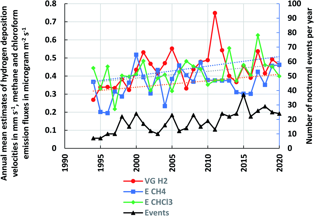 | ||
| Fig. 3 Number of nocturnal inversion events in each year and the annual mean hydrogen deposition velocities, methane and chloroform (scaled by 1000) emission fluxes from 1994–2020. | ||
Looking at the annual summaries for the emitted trace gases in Table 1 and Fig. 3, annual mean CH4 emission fluxes increased by about 85% from 0.27 μg m−2 s−1 averaged over the first five years to 0.5 μg m−2 s−1 averaged over the last five years. The three consecutive years, 2014–2016, gave anomalously low CH4 emission fluxes, see Fig. 3. If they were removed from the Mann-Kendall trend analysis, then a statistically significant upwards trend of +1.3% per year was found, at the 90% level of confidence. We have no explanation as to why these three years gave low CH4 emission rates other than the inherent variability of the peat bog ecosystems around Mace Head. Annual mean CHCl3 emission fluxes increased by about 27% from 0.37 ng m−2 s−1 averaged over 1994–1998 to 0.47 ng m−2 s−1 over 2016–2020. However, this trend was not found to be statistically significant using the Mann-Kendall test. A lowess-smoother (RobustFit, https://www.st-andrews.ac.uk/%7Ewjh/robustfit/) was fitted through the annual mean CHCl3 emission fluxes and the smoothed data were found to show a highly statistically significant upwards trend of +0.5% per year.
Seasonality in the trace gas deposition and emission events was examined in Table 2 by sorting the 502 nocturnal inversion events into meteorological seasons: winter DJF (December, January and February), spring MAM (March, April and May), summer JJA (June, July and August) and autumn SON (September, October and November). The number of nocturnal inversion events was highest during spring and lowest during winter. Deposition velocities for H2 were highest during autumn and winter and lowest during spring and summer. CH4 emission fluxes showed little seasonality whereas CHCl3 fluxes were highest in spring and summer and lowest in autumn and winter, in complete contrast to H2 deposition.
| Season | Number of events | H2 deposition velocity, mm s−1 | CH4 emission flux, μg m−2 s−1 | CHCl3 emission flux, ng m−2 s−1 |
|---|---|---|---|---|
| Winter DJF | 74 | 0.54 ± 0.47 | 0.42 ± 0.29 | 0.33 ± 0.24 |
| Spring MAM | 155 | 0.38 ± 0.24 | 0.34 ± 0.23 | 0.48 ± 0.33 |
| Summer JJA | 136 | 0.39 ± 0.22 | 0.36 ± 0.23 | 0.48 ± 0.31 |
| Autumn SON | 133 | 0.51 ± 0.40 | 0.38 ± 0.21 | 0.36 ± 0.24 |
4. Discussion and conclusions
The measured H2 deposition velocities at an urban parkland site in Finland over a four-year period were in the range 0.13–0.7 mm s−1, with an average value of 0.43 ± 0.04 mm s−1.38 A H2 deposition velocity has been reported of 0.35 mm s−1 to a marshland ecosystem in an eleven month study in California.39 The average deposition velocity measured here of 0.45 ± 0.3 mm s−1 is in close agreement with these two literature studies. We report an increase with time in the annual average deposition velocity of +1.2% per year. This is consistent with the observation of higher deposition velocities with higher temperatures reported in the literature.38CHCl3 emission estimates from several temperate ecosystems including a coastal peatland in Ireland lie in the range 2–92 nmol per m2 per day (0.028–0.13 ng m−2 s−1)8 and are much smaller in comparison with the present study of 320 ng per m2 per day (0.44 ng m−2 s−1). However, the estimates of CHCl3 emission rates estimated here in Table 1 are smaller than those reported in our previous study of the Connemara peat bogs for the overlapping period 1995–2008. Previously we found emission rates in the range 0.12–3.6 ng m−2 s−1 (0.44–12.94 μg per m2 per hour) with an average emission rate of 0.40 ng m−2 s−1 (2.91 ± 2.2 μg per m2 per hour).10 Over this same period, we report in Table 1, an average emission rate of 1.42 ± 0.3 μg per m2 per hour (0.40 ng m−2 s−1) for nominally the same events. However, because of the huge variability in CHCl3 emission estimates in both studies, the differences are unlikely to be statistically significant. In this study, we have been more selective in the events chosen for emission estimate analysis and rejected any events that have occurred after the break-up of the initial nocturnal inversion. This has reduced the overall uncertainties in our estimates and may have moved their distribution towards lower emission estimates. In view of the uncertainties found here and in our previous study, it is difficult to take further our observation of a statistically significant increase in CHCl3 emissions of 0.5% per year with time over the extended study period from 1995–2020.
The long-term average CH4 emission flux found here of 0.37 ± 0.2 μg m−2 s−1 (0.33 ± 0.07 μg m−2 s−1 in our previous study) compares favourably with the emission of 0.3 μg m−2 s−1 (7.1 g C per m2 per year) reported for northern peatland bog sites.5 A CH4 emission of 0.2 μg m−2 s−1 (6.2 g CH4 per m2 per year) has been reported for a lowland blanket bog in Ireland40 which is one third lower than our long-term average flux but well within our confidence interval. However, if account is taken of the time delay between the literature study37 and this study, together with the trend with time reported here a higher value would be expected.
One of the prime motivations for this study was the concern that CH4 emissions from peat bogs may have been affected by climate change. A statistically significant increase in CH4 emissions of +1.3% per year has been observed in this study of the Connemara peat bogs and it is tempting to associate this with a local change in climate. For this apparent association to be causation, there would need to be some further evidence linking the increased CH4 emissions with changes in the peat bog ecosystem. Unfortunately, no monitoring of the peat bog ecosystem was carried out simultaneously with the atmospheric monitoring. While recognizing that precipitation is only a rough proxy for actual water table levels, it has been reported that Ireland's wettest decade was from 2006–2015.41 The average annual rainfall during this decade was 1990 mm per year compared with a 300 year decadal average of 1080 mm per year. These observations are supported by the long-term records of rainfall in Ireland, which show upward trends in annual average rainfall.42,43
In Fig. 4a, we show an upwards trend in the annual average rainfall at Mace Head, compiled from the Met Éireaan data which commenced in 2004.44Fig. 4b–e illustrate the trends in the Mace Head seasonal rainfall. Only DJF shows a highly statistically significant positive trend at the 90% level of significance, with a slope of 3 ± 2.4–4.4 per year, where these are 2-sigma confidence limits. This is consistent with DJF having the highest CH4 emission flux as listed in Table 2. We also note weak positive trends in JJA and SON that are not statistically significant, while MAM has a weak negative trend. Feng et al.,6 recently discussed the importance of shifting precipitation accelerating microbial metabolic pathways beneficial for CH4 production. Moreover, independent of soil temperature, any seasonal hydroclimatic dynamic that increases water availability from earlier to later in the year is likely to increase annual CH4 emissions.6
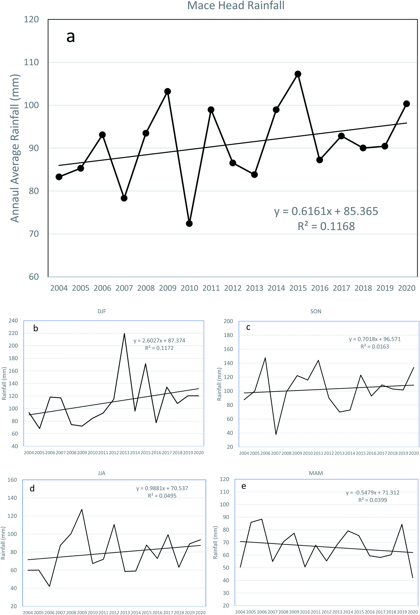 | ||
| Fig. 4 (a) Annual average rainfall at Mace Head, Ireland (2004–2020). (b–e) Seasonal average rainfall for DJF, SON, JJA and MAM, respectively. | ||
The CH4 emission literature5 points to an exponential relationship between water table depth and CH4 emissions which, on its own, would imply a 0.16 cm annual rise in water table depth to account for a 1.3% annual rise in CH4 emissions for blanket bogs. A major limitation of this present study is the lack of any observations of temperature, water table depth and other environmental conditions for the Connemara peat bog. However, it would seem plausible for the observed increase in rainfall to have accounted for the increase in CH4 emissions and for there to be a causal link to the change in local climate.
Our observed association between increasing natural CH4 emissions from the Connemara peat bogs and increasing rainfall over the 25 year period may have a wider global biogeochemical significance. If this association is causal and continues into the future, it would represent a positive climate feedback. A positive climate feedback occurs when an ecosystem, biological or physical response amplifies the driving climate forcing. Based on this study, we postulate that increased rainfall may drive increased natural CH4 emissions which lead to increased global CH4 levels which in turn decrease the CH4 lifetime, further increasing CH4 burdens, increasing radiative forcing and amplifying the climate change and further increasing rainfall. There would therefore be the possibility of a runaway CH4-driven greenhouse effect. Whether this is a likely future scenario, depends on whether the response seen here in Connemara to increased rainfall is causal and seen in other natural wetland ecosystems across the globe and on the accuracy and completeness of our understanding of the biogeochemistry of natural wetland ecosystems such as Connemara peat bogs.
Conflicts of interest
We confirm that there are no competing interests.Acknowledgements
This study was supported by various grants from the Department for Business, Energy & Industrial Strategy (BEIS, UK formerly the Department of Energy and Climate Change (DECC)), the National Aeronautical and Space Administration (NASA, USA), and the National Oceanic and Atmospheric Administration (NOAA, USA). We also thank Dr A Manning for valuable discussions on certain aspects of the paper.References
- IPCC, Climate Change 2013: the physical science basis, Cambridge University Press, Cambridge, UK, 2013 Search PubMed.
- T. Stein, Despite pandemic shutdowns, carbon dioxide and methane surged in 2020, NOAA Research News, Boulder, USA, 2021, https://research.noaa.gov/article/ArtMID/587/ArticleID/2742/Despite-pandemic-shutdowns-carbon-dioxide-and-methane-surged-in-2020 Search PubMed.
- M. Rigby and 18 co-authors, Role of atmospheric oxidation in recent methane growth, PNAS, 2017, 114, 5373–5377 CrossRef CAS PubMed.
- A. J. Turner, C. Frankenberg, P. O. Wennberg and D. J. Jacob, Ambiguity in the causes for decadal trends in atmospheric methane and hydroxyl, PNAS, 2017, 114, 5367–5372 CrossRef CAS PubMed.
- M. Abdalla, A. Hastings, J. Truu, M. Espenberg, U. Mander and P. Smith, Emissions of methane from northern peatlands: a review of management impacts and implications for management options, Ecol. Evol., 2016, 6, 7080–7102, DOI:10.1002/ece3.2469.
- X. Feng, M. J. Deventer, R. Lanchar, S. D. Sebestyen, D. T. Roman, T. J. Griffis, D. B. Millet and R. K. Kolka, Climate Sensitivity of Peatland Methane Emissions Mediated by Seasonal Hydrologic Dynamics, Geophys. Res. Lett., 2020, 47 DOI:10.1029/2020GL088875.
- R. G. Derwent, P. G. Simmonds, A. J. Manning, S. O'Doherty and T. G. Spain, Methane Emissions from peat bogs in the vicinity of the Mace Head Atmospheric Research Station over a 12-year period, Atmos. Environ., 2009, 43, 2328–2335 CrossRef CAS.
- C. H. Dimmer, P. G. Simmonds, G. Nickless and M. R. Bassford, Biogenic fluxes of halomethanes from Irish peatland ecosystems, Atmos. Environ., 2001, 35, 321–330 CrossRef CAS.
- M. L. Cox, P. J. Fraser, G. A. Sturrock, S. T. Siems and L. W. Porter, Terrestrial sources and sinks of halomethanes near Cape Grim, Tasmania, Atmos. Environ., 2004, 38, 3839–3852 CrossRef CAS.
- P. G. Simmonds, R. G. Derwent, A. J. Manning, S. O'Doherty and T. G. Spain, Natural chloroform emissions from the blanket peat bogs in the vicinity of Mace Head, Ireland over a 14-year period, Atmos. Environ., 2010, 44, 1284–1291 CrossRef CAS.
- R. C. Rhew, Y. A. The, T. Abel, A. Atwood and O. Mazeas, Chloroform emissions from the Alaskan Arctic tundra, Geophys. Res. Lett., 2008, 35, L21811, DOI:10.1029/2008GL035762.
- R. G. Derwent, P. G. Simmonds, S. J. O'Doherty, A. J. Manning, W. J. Collins and D. S. Stevenson, Global environmental impacts of the hydrogen economy, Int. J. Nucl. Hydrogen Prod. Appl., 2006, 1, 57–67 Search PubMed.
- R. G. Derwent, D. S. Stevenson, S. R. Utembe, M. E. Jenkin, A. H. Khan and D. E. Shallcross, Global modelling studies of hydrogen and its isotopomers using STOCHEM-CRI: Likely radiative forcing consequences of a future hydrogen economy, Int. J. Hydrogen Energy, 2020, 45, 9211–9221 CrossRef CAS.
- T. S. Rhee, C. A. M. Brenninkmeijer and T. Rockmann, The overwhelming role of soils in the global atmospheric hydrogen cycle, Atmos. Chem. Phys., 2006, 6, 1611–1625 CrossRef CAS.
- P. G. Simmonds, R. G. Derwent, S. O'Doherty, D. B. Ryall, L. P. Steele, R. L. Langenfelds, P. Salameh, H. J. Wang, C. H. Dimmer and L. E. Hudson, Continuous high-frequency observations of hydrogen at the Mace Head baseline atmospheric monitoring station over the period 1994 – 1998 period, J. Geophys. Res., 2000, 105, 12105–12121 CrossRef CAS.
- R. F. Hammond, Ireland Peatland Map, An Foras Taluntais, Dublin, 1978, https://www.teagasc.ie/media/website/environment/soil/Peatlands-of-Ireland-Map.pdf Search PubMed.
- R. F. Hammond, The Peatlands of Ireland, An Foras Taluntais, Dublin, 1981, https://www.teagasc.ie/media/website/environment/soil/Peatlands-of-Ireland.pdf Search PubMed.
- T. Whilde, The Natural History of Connemara, Immel Publishing, London, 1994, ISBN: 0-907151-91-4 Search PubMed.
- Irish Ramsar Wetlands Committee, Irish Wetland Types – an identification guide and field survey manual. EPA, Johnstown Castle, Ireland, 2018, ISBN: 978-1-84095-740-2, https://www.npws.ie/sites/default/files/general/irish-wetlands-guide.pdf Search PubMed.
- Central Statistics Office, Census of Ireland 2016, 2016, https://data.cso.ie/ Search PubMed.
- A. Grant, S. C. Witham, P. G. Simmonds, A. J. Manning and S. O'Doherty, A 15 year record of high-frequency, in situ measurements of hydrogen at Mace Head, Ireland, Atmos. Chem. Phys., 2010, 10(3), 1203–1214 CrossRef CAS.
- R. G. Prinn, R. F. Weiss, J. Arduini, T. Arnold, H. Langley Dewitt, P. J. Fraser, A. L. Ganesa, J. Gasore, C. M. Harth, O. Hermansen, J. Kim, P. B. Krummel, S. Li, Z. M. Loh, C. R. Lunder, M. Maione, A. J. Manning, B. R. Miller, B. Mitrevski, J. Mühle, S. O'doherty, S. Park, S. Reimann, M. Rigby, T. Saito, P. K. Salameh, R. Schmidt, P. G. Simmonds, L. P. Steele, M. K. Vollmer, R. H. Wang, B. Yao, Y. Yokouchi, D. Young and L. Zhou, History of chemically and radiatively important atmospheric gases from the Advanced Global Atmospheric Gases Experiment (AGAGE), Earth Syst. Sci. Data, 2018, 10, 985–1018, DOI:10.3334/CDIAC.
- R. G. Prinn, R. F. Weiss, P. J. Fraser, P. G. Simmonds, D. M. Cunnold, F. N. Alyea, S. O'Doherty, P. Salameh, B. R. Miller, J. Huang, R. H. J. Wang, D. E. Hartley, C. Harth, L. P. Steele, G. Sturrock, P. M. Midgley and A. McCulloch, A History of Chemically and Radiatively Important Gases in Air Deduced from ALE/GAGE/AGAGE, J. Geophys. Res., 2000, 105, 17751–17792 CrossRef CAS.
- A. Jordan and B. Steinberg, Calibration of atmospheric hydrogen measurements, Atmos. Meas. Tech., 2011, 4, 509–521, DOI:10.5194/amt-4-509-2011.
- B. Sweeney and B. Stacey, Intercomparison and intercalibration techniques employed for the U.K. National air monitoring networks, Warren Spring Laboratory Report, Stevenage, U.K, 1992 Search PubMed.
- C. Zellweger, J. Klausen and B. Buchmann, System and performance audit for surface ozone, carbon monoxide and methane, Global GAW Station Mace Head Ireland May 2005, EMPA Report 05/2, WMO World Calibration Centre for Surface Ozone, Carbon Monoxide and Methane, Dubendorf, Switzerland, 2005 Search PubMed.
- C. Zellweger, M. Steinbecher and B. Buchmann, System and performance audit of surface ozone, carbon monoxide, methane, carbon dioxide and nitrous oxide at the global GAW station Mace Head Ireland November 2018, WCC-Empa Report 18/2, World Meteorological Organization and Empa, Geneva, Switzerland, 2020 Search PubMed.
- R. G. Derwent, A. J. Manning, P. G. Simmonds, T. G. Spain and S. O'Doherty, Long-term trends in ozone in baseline and European regionally-polluted air at Mace Head, Ireland over a 30-year period, Atmos. Environ., 2018, 179, 279–287 CrossRef CAS.
- P. G. Simmonds, R. G. Derwent, A. J. Manning, A. Grant, S. O'Doherty and T. G. Spain, Estimation of hydrogen deposition velocities from 1995-2008 at Mace Head, Ireland using a simple box model and concurrent ozone depositions, Tellus B, 2011, 63, 40–51, DOI:10.1111/j.1600-0889.2010.00518.x.
- O. T. Denmead, R. Leuning, D. W. T. Griffith and C. P. Meter, Experimental designs appropriate to flux determination in terrestrial and aquatic ecosystems, in Approaches to Scaling of Terrestrial Gas Fluxes in Ecosystems. Developments in Atmospheric Science, ed. A. F. Bouwman, Elsevier, Amsterdam, The Netherlands, 1999, vol. 24, pp. 67–84 Search PubMed.
- O. E. Clifton and 20 co-authors, Dry deposition of ozone over land: Processes, measurement and modelling, Rev. Geophys., 2020, 58, e2019RG000670, DOI:10.1029/2019RG000670.
- M. Lin, S. Malyshev, E. Shevliakova, F. Paulot, L. W. Horowitz, S. Fares, T. N. Mikkelsen and L. Zhang, Sensitivity of ozone dry deposition to ecosystem-atmosphere interactions: A critical appraisal of observations and simulations, Global Biogeochem. Cycles, 2019, 33, 1264–1288, DOI:10.1029/2018GB006157.
- S. J. Silva and C. L. Heald, Investigating dry deposition of ozone to vegetation, J. Geophys. Res., 2018, 123, 559–573, DOI:10.1002/2017JD027278.
- D. Fowler, C. Fletchard, J. N. Cape, R. L. Storeton-West and M. Coyle, Measurements of ozone deposition to vegetation quantifying the flux, the stomatal and non-stomatal components, Water, Air, Soil Pollut., 2001, 130, 63–74 CrossRef CAS.
- M. Coyle, The gaseous exchange of ozone at terrestrial surfaces: non-stomatal deposition to grassland, PhD thesis, University of Edinburgh, Scotland, 2006.
- T. S. El-Madany, K. Niklasch and O. Klemm, Stomatal and Non-Stomatal Turbulent Deposition Flux of Ozone to a Managed Peatland, Atmosphere, 2017, 8, 175 CrossRef.
- T. Salmi, A. Maata, P. Antilla, T. Ruoho-Airola and T. Amnell, Detecting trends of annual values of atmospheric pollutants by the Mann-Kendall test and Sen's slope estimates – The Excel template application MAKESENS, Finnish Meteorological Institute, Helsinki, Finland, 2002 Search PubMed.
- M. Lallo, T. Aalto, J. Hatakka and T. Laurila, Hydrogen soil deposition at an urban site in Finland, Atmos. Chem. Phys., 2009, 9, 8559–8571 CrossRef CAS.
- N. V. Smith-Downey, J. T. Randerson and J. M. Eiler, Molecular hydrogen uptake by soil in forest, desert and marsh ecosystems in California, J. Geophys. Res., 2008, 113, G03057, DOI:10.1029/2008JG000701.
- A. Laine, D. Wilson, G. Kiely and K. A. Byrne, Methane flux dynamics in an Irish lowland blanket bog, Plant Soil, 2007, 299, 181–193 CrossRef CAS.
- The Irish Time Ltd, Jack Power. “Past 10 years have been Ireland's wettest in 300, say climate researchers. Rise in rainfall ‘attributable to human-driven climate change”, May 6, 2021 Search PubMed.
- S. Noone, C. Murphy, J. Coll, T. Matthews, D. Mullan, R. L. Wilby and S. Walsh, Homogenization and analysis of an expanded long-term monthly rainfall network for the Island of Ireland (1850-2010), Int. J. Climatol., 2016, 36, 2837–21853 CrossRef.
- C. Murphy, C. Broderick, T. P. Burt, M. Curley, C. Duffy, J. Hall, S. Harrigan, T. K. R. Matthews, N. Macdonald, G. McCarthy, M. P. McCarthy, D. Mullan, S. Noone, T. J. Osborn, C. Ryan, J. Sweeney, P. W. Thorne, S. Walsh and R. L. Wilby, A 305-year continuous monthly rainfall series for the island of Ireland (1711-2016), Clim. Past, 2018, 14, 413–440, DOI:10.5194/cp-14-413-2018.
- Met Éireaan, The Irish Meteorological Service, 65/67 Glasnevin Hill, Dublin 9, D09 Y921, Ireland, 2004–2020 Search PubMed.
| This journal is © The Royal Society of Chemistry 2021 |