
Editorial Perspectives: the need for a comprehensive, centralized database of interbasin water transfers in the United States
Kerim E.
Dickson
 a,
Landon T.
Marston
a and
David A.
Dzombak
*b
a,
Landon T.
Marston
a and
David A.
Dzombak
*b
aDepartment of Civil Engineering, Kansas State University, Manhattan, KS 66506, USA
bDepartment of Civil and Environmental Engineering, Carnegie Mellon University, Pittsburgh, PA 15213, USA. E-mail: dzombak@cmu.edu
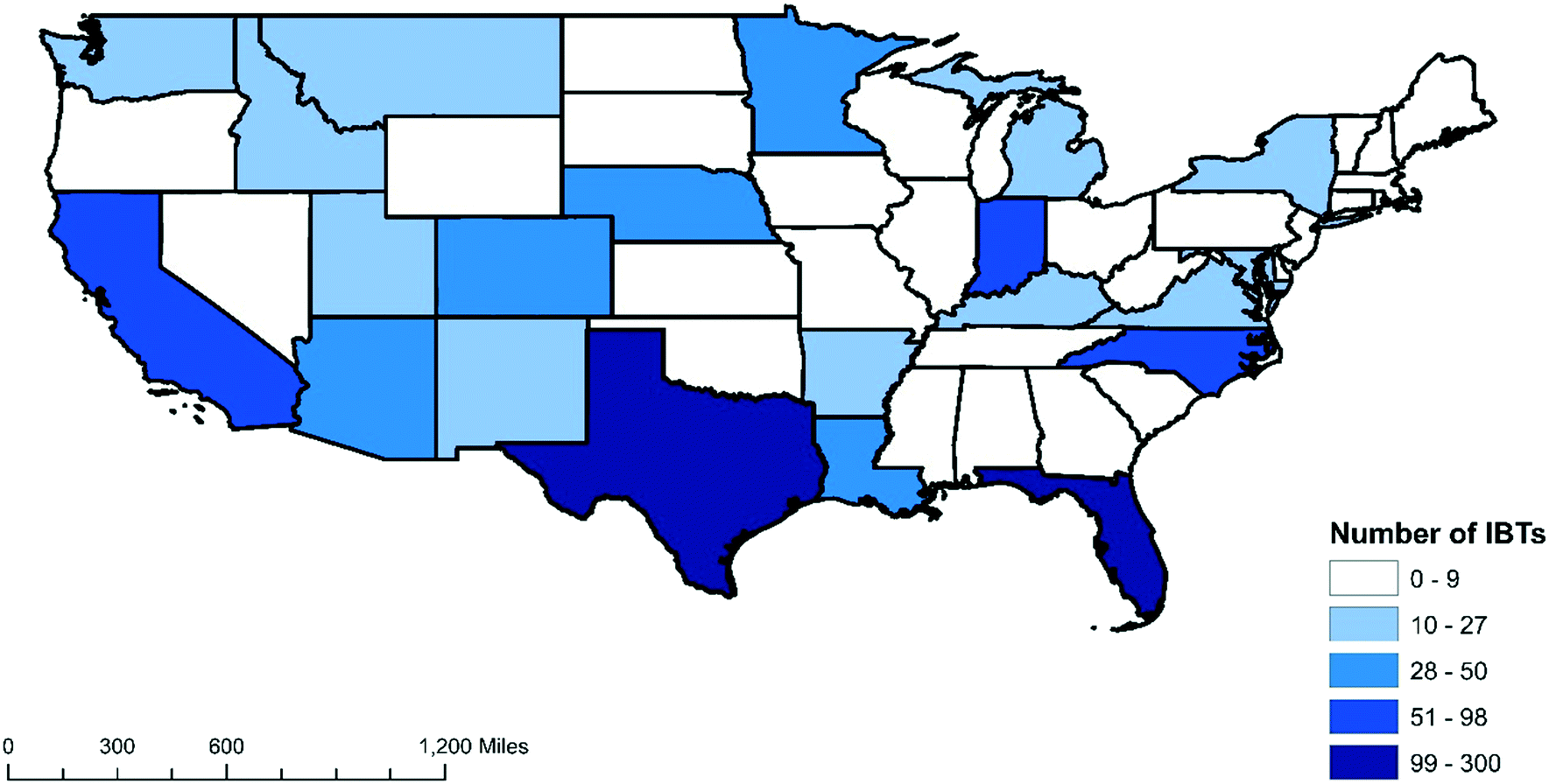 | ||
| Fig. 1 Number of interbasin transfers identified within the continental U.S. at the Hydrologic Unit Code 4 (HUC4) level. | ||
Interbasin water transfers can have significant impacts on the donor and recipient basins and on the availability of water across the regions that encompass the basins. For example, along the Colorado River several water transfers shift water across the continental divide, diverting a portion of the river's water to the Gulf of Mexico instead of the Gulf of California. These upstream water transfers reduce downstream flows, limiting available water supply for instream environmental flows and for downstream states that receive a legally-determined allocation from the Colorado River. Further downstream, additional transfers divert water from the Colorado River to water-thirsty cities and farms in southern California, Nevada, and Arizona. All of these water transfers complicate water budgets, making it challenging to conduct hydrologic studies and water management planning since information regarding such transfers is limited. A comprehensive IBT database would enable accurate accounting of human-mediated water transfers between basins, thereby providing improved estimates of water available for human and ecologic needs and facilitating identification of areas where water stress may occur.
Interbasin transfers confound water use assessments in that they dislocate the point of water extraction from the point of water use. The U.S. Geological Survey (USGS) National Water Census, which includes a national water-use compilation, reports county-level water use as withdrawals from surface water and groundwater sources.2 Reported water withdrawals indicate where water is diverted from water sources, but these records do not capture where the water is actually consumed, nor where return flows go. An example of the spatial disconnect between water withdrawals and use in water use assessments is provided by New York City. While the total population of New York City is in excess of 8 million people, no public supply withdrawals are listed in the National Water Census2 for the five New York City boroughs, as the water is mostly transferred via the Catskill and Delaware aqueducts from over 80 miles away. This creates uncertainty within the dataset as withdrawals cannot be assumed as being utilized locally. Alternatively, estimates of water consumption often assume water comes from local sources but this may not be the case. Remote sensing is revolutionizing how we estimate consumptive water use (e.g., https://etdata.org/) but this approach is unable to convey information on the sources of consumed water. This spatial disconnect between where water is sourced and where it is used impacts planning and management strategies at all scales. Inclusion in a comprehensive IBT database of information that links extraction locations with end users will allow for assessments to link withdrawals and consumptive use, reducing uncertainty in regularly produced water resources datasets and minimizing unknowns within local and national modeling.
Hydrologic models aid water resource researchers and planners in developing quantitative assessments of water fluxes and storage that can be used in decision-making. Significant modeling and computational advances over the last two decades have increased the spatial scale and resolution of these models (many high-resolution national and global models now exist, e.g.ref. 3–6), while also improving model fidelity through better representation of both natural processes and human activity. While existing models can benefit from and easily represent IBTs within their modeling framework, none of these large-scale hydrologic models adequately represent water transfers due to data limitations. The USGS Water Census and the U.S. Army Corps of Engineers National Inventory of Dams provide data on water withdrawals and the location, storage, and purposes of over 90![[thin space (1/6-em)]](https://www.rsc.org/images/entities/char_2009.gif) 000 dams across the U.S., which can be used to represent these human influences within hydrologic models. However, a corollary database with flow information for IBTs does not exist. The lack of a comprehensive IBT database leads hydrologic models to misrepresent key hydrologic variables and produce inaccurate predictions that can misinform decision-makers as they plan and manage water resources.
000 dams across the U.S., which can be used to represent these human influences within hydrologic models. However, a corollary database with flow information for IBTs does not exist. The lack of a comprehensive IBT database leads hydrologic models to misrepresent key hydrologic variables and produce inaccurate predictions that can misinform decision-makers as they plan and manage water resources.
A U.S. national research effort and cooperation in data sharing among local, state, and federal agencies is required to build upon the IBT inventory initiated by Dickson and Dzombak1 to include information on important characteristics of water transfers, such as the amount of water transferred by each conveyance and the proposed use of the conveyed water. Much of the needed data likely exists within databases maintained by local or federal agencies – it needs to be aggregated within a common data framework and made public. A U.S. national effort that includes several academic institutions and the USGS to compile this disparate data into a single publicly accessible national database is being conducted but requires input from all organizations that maintain relevant information. This research effort aims to complete a comprehensive inventory of IBTs, including flow and other information, to enable improvement of modeling and understanding of the impact of IBTs on water availability and environmental flows throughout the nation. Comprehensive information on IBTs will improve water supply planning and management, and water resource sustainability, potentially providing a framework to facilitate IBT analysis in other countries globally.
Acknowledgements
Landon Marston acknowledges the support of the U.S. Geological Survey under Grant/Cooperative Agreement No. G20AP00002, upon which this work is based. The views and conclusions contained in this document are those of the authors and should not be interpreted as representing the opinions or policies of the U.S. Geological Survey. Mention of trade names or commercial products does not constitute their endorsement by the U.S. Geological Survey.References
- K. E. Dickson and D. A. Dzombak, Inventory of Interbasin Transfers in the United States, J. Am. Water Resour. Assoc., 2017, 53(5), 1121–1132, DOI:10.1111/1752-1688.12561.
- C. A. Dieter, K. S. Linsey, R. R. Caldwell, M. A. Harris, T. I. Ivahnenko, J. K. Lovelace, M. A. Maupin and N. L. Barber, Estimated Use of Water in the United States County-Level Data for 2015 (ver. 2.0, June 2018), U.S. Geological Survey data release, 2018 DOI:10.5066/F7TB15V5.
- S. Cohen, S. Praskievicz and D. R. Maidment, Featured Collection Introduction: National Water Model, J. Am. Water Resour. Assoc., 2018, 54(4), 767–769, DOI:10.1111/1752-1688.12664.
- H. Müller Schmied, L. Adam, S. Eisner, G. Fink, M. Flörke, H. Kim, T. Oki, F. T. Portmann, R. Reinecke, C. Riedel, Q. Song, J. Zhang and P. Döll, Variations of global and continental water balance components as impacted by climate forcing uncertainty and human water use, Hydrol. Earth Syst. Sci., 2016, 20(7), 2877–2898 CrossRef.
- J. M. Myers, P. Caldwell, S. McNulty, G. Sun and E. Cohen, WaSSI: A New Web-based Tool Assesses Water Supply, GEO World, 2013, 26(7), 26 Search PubMed.
- Y. Wada, D. Wisser and M. F. Bierkens, Global modeling of withdrawal, allocation and consumptive use of surface water and groundwater resources, Earth Syst. Dyn., 2014, 5(1), 15–40, DOI:10.5194/esd-5-15-2014.
| This journal is © The Royal Society of Chemistry 2020 |