
 Open Access Article
 This Open Access Article is licensed under a
 Creative Commons Attribution 3.0 Unported Licence
Interannual, summer, and diel variability of CH4 and CO2 effluxes from Toolik Lake, Alaska, during the ice-free periods 2010–2015†
Werner
Eugster
 *a,
Tonya
DelSontro
b,
Gaius R.
Shaver
c and
George W.
Kling
d
*a,
Tonya
DelSontro
b,
Gaius R.
Shaver
c and
George W.
Kling
d
aInstitute of Agricultural Sciences, Department of Environmental Systems Science, ETH Zürich, CH-8092 Zürich, Switzerland. E-mail: eugsterw@ethz.ch
bDepartment F.-A. Forel, Faculty of Science, University of Geneva, CH-1211 Geneva, Switzerland. E-mail: tdelsontro@gmail.com
cThe Ecosystems Center, Marine Biological Laboratory, Woods Hole, MA, USA. E-mail: gshaver@mbl.edu
dUniversity of Michigan, Ann Arbor, MI, USA. E-mail: gwk@umich.edu
First published on 9th July 2020
Abstract
Accelerated warming in the Arctic has led to concern regarding the amount of carbon emission potential from Arctic water bodies. Yet, aquatic carbon dioxide (CO2) and methane (CH4) flux measurements remain scarce, particularly at high resolution and over long periods of time. Effluxes of methane (CH4) and carbon dioxide (CO2) from Toolik Lake, a deep glacial lake in northern Alaska, were measured for the first time with the direct eddy covariance (EC) flux technique during six ice-free lake periods (2010–2015). CO2 flux estimates from the lake (daily average efflux of 16.7 ± 5.3 mmol m−2 d−1) were in good agreement with earlier estimates from 1975–1989 using different methods. CH4 effluxes in 2010–2015 (averaging 0.13 ± 0.06 mmol m−2 d−1) showed an interannual variation that was 4.1 times greater than median diel variations, but mean fluxes were almost one order of magnitude lower than earlier estimates obtained from single water samples in 1990 and 2011–2012. The overall global warming potential (GWP) of Toolik Lake is thus governed mostly by CO2 effluxes, contributing 86–93% of the ice-free period GWP of 26–90 g CO2,eq m−2. Diel variation in fluxes was also important, with up to a 2-fold (CH4) to 4-fold (CO2) difference between the highest nighttime and lowest daytime effluxes. Within the summer ice-free period, on average, CH4 fluxes increased 2-fold during the first half of the summer, then remained almost constant, whereas CO2 effluxes remained almost constant over the entire summer, ending with a linear increase during the last 1–2 weeks of measurements. Due to the cold bottom temperatures of this 26 m deep lake, and the absence of ebullition and episodic flux events, Toolik Lake and other deep glacial lakes are likely not hot spots for greenhouse gas emissions, but they still contribute to the overall GWP of the Arctic.
Environmental significanceVast amounts of organic carbon are stored in Arctic permafrost soils. With climate warming it can be expected that an increasing amount of that carbon is freed as permafrost thaws, and can escape to the atmosphere via gas efflux from lakes. With the first continuous eddy covariance flux measurements over a deep Arctic lake in Alaska we provide evidence that during the ice-free period the effluxes of both CH4 and CO2 show pronounced diel and summer variations which are important, but no signs of episodic events with extremely high effluxes during the ice-free period could be found. This is in agreement with earlier estimates made for the Arctic and emphasizes the fact that deeper Arctic lakes are not the water bodies to be most concerned about regarding carbon emissions; however, better estimates of gas fluxes from the shallow lake-shore zones of such lakes are still needed. |
1 Introduction
Arctic regions contain a vast reservoir of organic matter preserved in permafrost, the permanently frozen ground in northern high latitudes.1 With climate warming, thawing of permafrost and the associated exposure of its organic matter to decomposition has become a great concern as a positive but unwanted feedback of the Arctic to climate change.2–4 The role of open water bodies in the Arctic, which cover about 12–14 percent of the land surface area of the Alaskan North Slope5,6 and up to 48% in some regions of Alaska,7,8 has thus taken a prominent place in the estimate of greenhouse gas fluxes from Arctic ecosystems.9 In this paper, we present eddy covariance (EC) flux measurements of the two primary greenhouse gases (CH4 and CO2) obtained during six ice-free lake periods (2010–2015). Because CH4 effluxes have a climatic effect that is ≈34 times that of CO2 effluxes10 (on a 100 year time-scale, including positive climatic feedbacks), our interest was in how continuous CH4 flux measurements over Toolik Lake change previous estimates of Global Warming Potential (GWP) from Arctic lakes that were based only on CO2 flux measurements (e.g., Eugster et al. 2003 (ref. 11)), but without an estimation of CH4 effluxes.Based on reports of huge amounts of CH4 emitted from some Arctic water bodies,12–16 expectations have become high that many or most Arctic lakes are or could be strong sources of CH4, but also not everywhere.17,18 With discrete sampling, e.g., bi-weekly surveys of CH4 and CO2 concentrations in lake surface waters or discrete short-term deployments of floating chambers to measure gas efflux at specific times, episodic events that could dominate daily or summer emissions would easily be missed or under sampled, particularly for CH4.19,20 Missing such events would lead to biased results and underestimates of emissions, but could be circumvented by using a higher resolution method, such as EC. For example, significant efflux events were observed during fall turnover21 and after a substantial storm22 in two Swiss lakes using EC. In addition to episodic events, strong diel patterns20,23–26 could affect estimates of gas fluxes depending on when in the day samples were taken. Continuous monitoring techniques are essential for resolving such events. Furthermore, repeated measurements over several years at the same site, required for climatological studies, are limited in the Arctic.
Based on the first long-term EC flux measurements from a deep Arctic lake, this paper addresses the question: what cyclical processes and which episodic events are most relevant for obtaining a defensible ice-free period estimate of CH4 and CO2 effluxes from a deep Arctic lake? It also provides the foundation for follow-up investigations of the underlying mechanistic functional relationships between these fluxes and environmental drivers.
2 Experimental
2.1 Study site
Measurements were made on Toolik Lake (68°37.830′ N, 149°36.366′ W, WGS84 datum) at 719 m asl, a relatively deep glacial lake (maximum depth ≈ 26 m) with a surface area of 1.5 km2 located on the tundra north of the Alaskan Brooks Range. Instruments were mounted on a floating platform that was moored at approximately the same location every year ≈ 400 m from the nearest lake shore. Depth of the lake at this location was ≈12 m.With the onset of snowmelt the ice on Toolik Lake begins to melt. Observations made in 2014 showed that the water arriving via overland flow and the main stream inlets initially flow over the thick ice sheet and gradually melt the ice from above along the shoreline, and then the flows move mainly under the ice and spread lakewide.27 Once the ice sheet is sufficiently detached from the lake shores, stronger winds and associated waves can crack the ice, which then still covers most of the lake with floating chunks of ice that move around the lake as the wind shifts between the two predominant wind directions from the south and the north. The physical forces at work are too strong for eddy covariance instrumentation to be out on the lake. Therefore, the placement of equipment on the lake was only possible when the largest ice chunks on the lake were less than a few square-meters and few in number, typically between mid to late June (Table 1).
| Year | 2010 | 2011 | 2012 | 2013 | 2014 | 2015 | Mean |
| Lake ice-off (thaw)73 | Jun 14 | Jun 16 | Jun 17 | Jun 28 | Jun 24 | Jun 10 | Jun 18 |
| Lake 100% ice covered (freeze)73 | Oct 09 | Oct 15 | Oct 15 | Oct 02 | Oct 04 | Sep 27 | Oct 07 |
| Ice-free days | 117 | 121 | 120 | 96 | 102 | 109 | 111 |
![[thin space (1/6-em)]](https://www.rsc.org/images/entities/char_2009.gif) |
|||||||
| Period with EC flux measurements on Toolik Lake | |||||||
| EC to lake | Jun 22 | Jun 14 | Jun 21 | Jun 29 | Jun 28 | Jun 20 | Jun 23 |
| EC from lake | Aug 18 | Aug 20 | Aug 22 | Aug 17 | Aug 22 | Aug 21 | Aug 20 |
| EC days | 55.9 | 64.7 | 60.6 | 48.6 | 54.9 | 61.4 | 57.7 |
| EC coverage (%) | 98.1 | 98.1 | 97.8 | 98.4 | 98.9 | 99.1 | 98.4 |
| Half-hourly CH4 flux records | 2685 | 1724 | 2911 | 2333 | 2636 | 2441 | |
| …acceptable quality (%) | 84.6 | 50.4 | 94.2 | 90.6 | 90.5 | 63.2 | 78.9 |
| …best quality (%) | 58.6 | 33.6 | 67.2 | 62.6 | 66.7 | 46.3 | 55.8 |
| CH4 flux mean (mmol m−2 d−1) | 0.119 | 0.063 | 0.201 | 0.130 | 0.093 | 0.147 | 0.126 |
| CH4 flux SD (mmol m−2 d−1) | 0.074 | 0.058 | 0.075 | 0.049 | 0.038 | 0.070 | 0.061 |
| Half-hourly CO2 flux records | 2644 | 1724 | 2908 | 2333 | 2586 | 2606 | |
| …acceptable quality (%) | 87 | 51.4 | 92.6 | 82.4 | 93.4 | 74.6 | 80.2 |
| …best quality (%) | 59.6 | 34.4 | 66.5 | 56.5 | 68.9 | 53.1 | 56.5 |
| CO2 flux mean (mmol m−2 d−1) | 8.9 | 11.0 | 30.9 | 21.9 | 12.9 | 14.4 | 16.7 |
| CO2 flux SD (mmol m−2 d−1) | 4.2 | 3.0 | 7.4 | 7.6 | 4.3 | 5.3 | 5.3 |
|
|||||||
| Estimated global warming potential (GWP) during ice-free period | |||||||
| CH4 flux sum (mg CH4 m−2) | 222.1 | 122.3 | 386.3 | 199.8 | 152.3 | 256.8 | 223.2 |
| CO2 flux sum (g CO2 m−2) | 46.0 | 58.4 | 163.5 | 92.3 | 57.8 | 67.7 | 81.0 |
| Ice-free GWP (g CO2,eq m−2) | 53.5 | 62.6 | 176.6 | 99.1 | 63.0 | 76.5 | 88.6 |
Similar to the early-season conditions, the float containing eddy covariance instrumentation had to be removed from the lake before any large ice areas had formed on the lake in the autumn. Ice-on after the ice-free period was defined as the time when ice first covered the entire lake until the following spring (i.e., temporary ice cover over night was not considered as the first ice-on date). In this context it should be recalled that at this northern location the sun does not set from 23 May to 19 July, and thus “night” refers to the hours of day with lowest solar elevation angles. At the end of summers from 2010–2015, however, ice formation occurred later than observed in earlier years, and thus the platform was removed between 17 and 22 August for logistical reasons (Table 1).
2.2 Eddy covariance flux instrumentation
Flux measurements were made with a three-dimensional ultrasonic anemometer–thermometer (CSAT3, Campbell Scientific, Logan, UT, USA) in combination with a closed-path integrated off-axis cavity output spectrometer (ICOS) for CH4 (FMA from Los Gatos Research, Inc., San Jose, CA, USA) and a nondispersive infra-red gas analyzer for CO2 and H2O (Li-7000, Li-Cor Inc., Lincoln, NE, USA). The CSAT-3 was mounted horizontally on a tripod (Met One Instruments, Inc., Grants Pass, OR, USA) screwed to the floating platform in such a way that measurement height above the lake surface was between 1.29 m and 1.62 m above the water surface. Two intake hoses were placed next to the CSAT-3 sensor head to guide air to the FMA and Li-7000 analyzers. A TriScroll 300 vacuum pump (Agilent, Santa Clara, CA, USA) was used to reduce the cell pressure of the FMA to the nominal 137 Torr (183 hPa). The Li-7000 did not require a vacuum in the sample cell, which allowed use of a KNF Neuberger N920 pump. A 500 m submersible AC power cable was used to provide the instruments and pumps on the float with mains power (120/240 V AC) from the power generator of Toolik Field Station (TFS). A step-up transformation of the voltage from 120 V AC to 600 V AC was necessary between lake shore and float to satisfy the high power demand of the vacuum pump.The CH4 flux measurements closely followed the technical set-up described in detail by Eugster and Plüss.28 The CO2 flux measurements used the same data collection concept. This data collection system consisted of an embedded Linux computer system (MOXA UC7408 Plus; Moxa Americas, Brea, CA, USA) to which the CSAT-3, FMA, and Li-7000 were connected via RS-232 serial communication connections. The continuous data stream from the CSAT-3 was recorded at 20 Hz and was used as the master to which the data streams from the FMA and the Li-7000 were merged in near real-time as described by Eugster and Plüss.28 The system clock of the Linux computer was synchronized daily with internet network time domain servers, whenever the wireless link from the floating platform to TFS was active.
Instruments were not disturbed during the measurements unless maintenance, troubleshooting or additional sampling of surface waters were necessary. Ancillary meteorological data and data from sensors in the lake water were operated during the field seasons, but will be presented in a follow-up study where the response of fluxes to environmental drivers will be addressed in detail; the aim of the current paper is to assess the relevant timescales of variations that must be addressed in such a follow-up study.
2.3 Flux calculations
Flux calculations and quality control procedures closely followed the recommendations given by Vesala et al.29 Our in-house eddy covariance flux software (eth-flux30) was adapted to the specific datasets obtained from Toolik Lake, but closely corresponds to standard procedures used for long-term flux measurements over land.31–33 The same calculation method was used in an earlier study using similar equipment.22In brief: calculations included (1) coordinate rotation of each 30 minute data segment to align the wind vector with the mean wind direction, thereby making (a) mean lateral wind speed ![[v with combining macron]](https://www.rsc.org/images/entities/i_char_0076_0304.gif) = 0 m s−1 and (b) mean vertical wind speed
= 0 m s−1 and (b) mean vertical wind speed ![[w with combining macron]](https://www.rsc.org/images/entities/i_char_0077_0304.gif) = 0 m s−1; (2) screening out unrealistic CO2 mole fractions > 3000 ppm or < 330 ppm, or when the Li-7000 cell pressure was >1000 hPa or <500 hPa; (3) screening out unrealistic CH4 mole fractions when the FMA sample cell pressure was >149.7 Torr or <122.0 Torr, or ringdown time was <16.5 ms; (3) determination of time lag between vertical wind speed and CH4 and CO2, respectively; (4) shifting the time series according to these lags within each 30 minute interval; (5) calculation of covariances; and (6) correction for density fluctuations caused my moisture flux (WPL correction;34 details of the specific approach used here were given by Hiller et al.35).
= 0 m s−1; (2) screening out unrealistic CO2 mole fractions > 3000 ppm or < 330 ppm, or when the Li-7000 cell pressure was >1000 hPa or <500 hPa; (3) screening out unrealistic CH4 mole fractions when the FMA sample cell pressure was >149.7 Torr or <122.0 Torr, or ringdown time was <16.5 ms; (3) determination of time lag between vertical wind speed and CH4 and CO2, respectively; (4) shifting the time series according to these lags within each 30 minute interval; (5) calculation of covariances; and (6) correction for density fluctuations caused my moisture flux (WPL correction;34 details of the specific approach used here were given by Hiller et al.35).
Wave motion may affect the measurements obtained from an eddy covariance system. As investigated in detail by Eugster et al. (2003)11 (see their Fig. 6), this mostly affects the variance of vertical wind speed with an increase on the order of 6%, but the effect is much small when reflected in the fluxes (or cospectrum11). Thus, no special flux correction to eliminate the traces of this oscillation was applied.11
The uncertainty of flux estimates was assessed based on statistical significance of covariances.36–39 For data of best and good quality (flags 0 and 1 according to Foken et al.33), we obtained a median detection limit of 30 minute flux averages of ±1.12 nmol CH4m−2 s−1 and 0.12 μmol CO2 m−2 s−1. This translates to uncertainties of ±0.16 nmol CH4 m−2 s−1 and 0.017μmol CO2 m−2 s−1 for daily median fluxes (average of 48 records), or better for median diel cycles at hourly resolution (average of up to 120 records per hour).
2.4 Gapfilling of missing flux data
To obtain daily and ice-free summer totals of fluxes, a procedure to fill data gaps is required. Here we only used measured and quality controlled data for the analysis, except for two special cases where gap filling was necessary: (i) the assessment of summer variations; and (ii) obtaining ice-free summer flux totals during the period of instrument deployment. The quality control procedure used here follows the flagging procedure suggested by Foken et al.33,40 Both an integral turbulence test (ITC) and a steady-state test (SST) were performed using the 9-level flagging system, from which a general overall flux flag (range 1–9) was deduced according to Foken et al.33,40Table 1 gives the percentages of records that remained for the analysis. Acceptable quality refers to flags 1–8, and best quality refers to flags 1–6, whereas fluxes with flag 9 were not considered. Fluxes up to flag 8 were kept in the analysis to avoid potential erroneous removal of fluxes during ebullition events.41Because no established procedure exists for filling flux data gaps in measurements carried out over a lake, we used the median diel cycle approach for short gaps up to 1.5 days. For each 30 minute gap in the dataset the available measurements from the same hour of day measured up to 3 days before and after the date with the gap were considered to obtain the median flux for that hour of day in the period to fill the gap. In our dataset, 74–97% of the gaps observed in each summer season filled in this way were shorter than 3 hours, and 86–98% were shorter than 12 hours, except for 2011 (52% shorter than 3 hours). Compared to simple linear interpolation of short gaps, this procedure has the advantage that it is more robust when the longer-term flux signal is small compared to the variations from one available averaging interval to the next.
Gaps that were longer than 1.5 days were only filled for obtaining seasonal flux estimates using the daily average from the measured fraction of the respective season (see Section 4.5).
2.5 Lake surface temperature and stability measurements
Lake surface temperatures Ts (°C) were measured with a down-looking CG3 pyrgeometer (Kipp & Zonen, Delft, the Netherlands) of a four-way CNR1 net-radiometer using Stefan–Boltzmann's law,42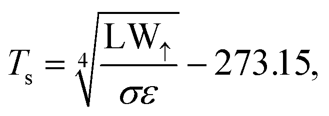 | (1) |
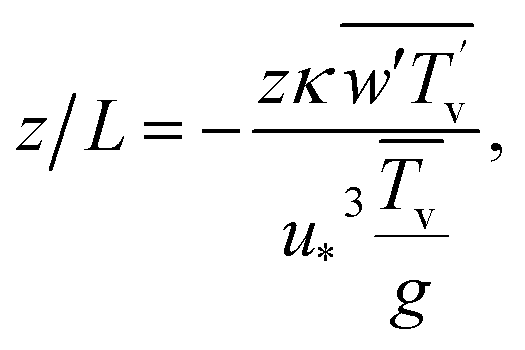
The Monin–Obukhov44 stability parameter z/L was determined from EC flux measurements as
 | (2) |
 buoyancy flux (K m s−1), u* the friction velocity (m s−1), Tv virtual (sonic) temperature (K), and g the gravitational acceleration (9.81 m s−2).
2.6 Statistical analyses
All statistical analyses were done with the open-source statistical software R version 3.6.1.45 Both CH4 and CO2 fluxes measured over lakes tend to show a variability of 30 minute average fluxes that is much larger than the longer-term mean flux itself. Hence, we mostly use robust statistics (median, quantiles, inter-quartile range) in our analysis. For comparability with other published values we also report arithmetic means and standard deviations, which are commonly used when sampling discretely with floating chambers.Spline smoothing was done with a local polynomial regression fitting (loess function in R); the span parameter for smoothing set to 0.5 when smoothing diel cycles of data, and to 0.25 when smoothing ice-free period data.
For a quantitative assessment of the relevance of diel and weekly cycles we proceeded as follows: the five wavelets with periods centered with the diel or weekly cycle were used to determine the fraction of measurements with a statistically significant cyclicity (i.e., the wavelet power > the significance threshold determined by the wavelet analysis). The five wavelets used for this assessment have a bandwidth of 20 to 27 hours for the diel cycle, and 5.9 to 7.8 days for the weekly cycles that we report for each summer season.
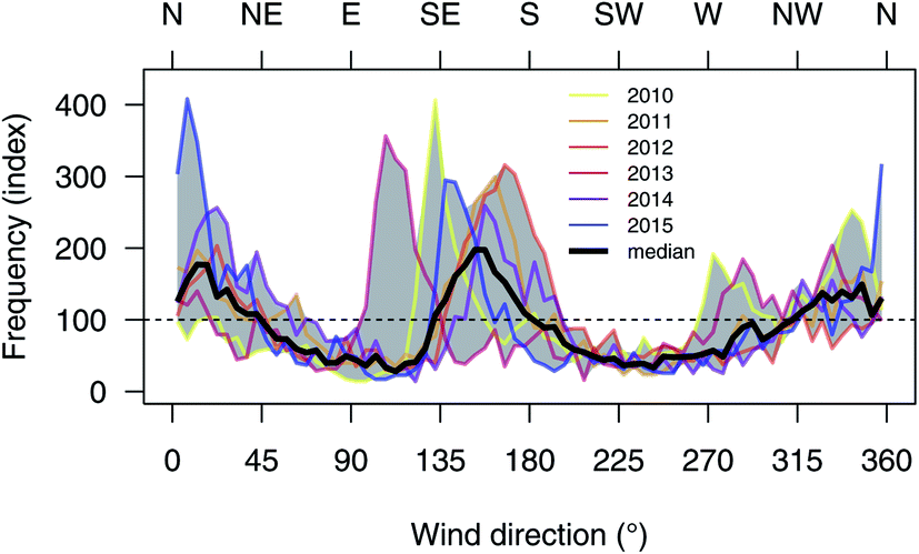 | ||
| Fig. 1 Wind direction frequencies during ice-off periods 2010–2015 at Toolik Lake. The frequency index 100 indicates the expectation value of a uniform distribution of wind directions. The gray band shows the range of all six years, the bold line is the median from all years. Note that the measurement platform mooring was not rigid, and thus the shift in peak wind directions in the E–S sector rather reflects the differences in configuration of the platform mooring during individual summers, and most likely is not indicating a real difference in wind directions. | ||
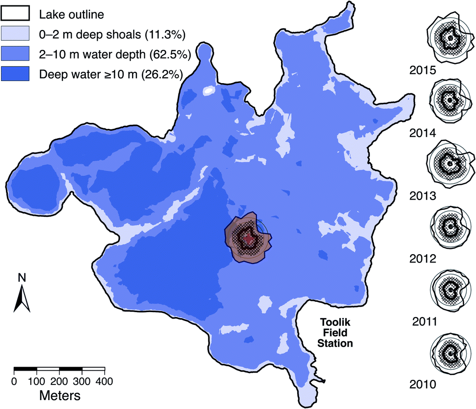 | ||
| Fig. 2 Flux footprints for each ice-free period 2010–2015. The footprint of 2015 is also placed at correct scale on the bathymetric map of Toolik Lake. The outer bold lines indicate the extent of the 90% flux footprint area of the entire summer. The bold line in the hashed area (25–75% footprint area) of each footprint is the median distance from the EC measurements (in the center of each footprint). Circles show equal distances from the EC instruments at 10, 30, 50, 70, and 90 m. Toolik Lake bathymetric map by Toolik Field Station GIS. | ||
It is well known that CH4 and CO2 concentrations are not constant in the surface waters of a lake.50 Manual sampling of surface water CH4 and CO2 pressures in all summer seasons 2010–2015 showed a clear supersaturation of both gases with respect to the atmosphere (G. W. Kling, pers. comm.). This supersaturation might be somewhat stronger over shallower parts of the lake, and thus these measurements might underestimate the supersaturation for the entire lake. However, because of our analysis of the eddy flux footprint (see Fig. 2) we assume that our flux measurements are representative for the part of Toolik Lake that is deeper than 2 m (>85% of Toolike Lake; Fig. 2).
2.7 Sonar surveys to detect ebullition
In 2012 an extensive sonar survey was carried out in a similar way as was done by DelSontro et al.51 before using a 120 kHz (7° beam angle) split-beam scientific echosounder (Simrad EK60, Kongsberg Maritime, Norway), operating at 5 Hz. Surveys were carried out on 19, 23, and 24 July 2012, covering a total footprint area of 8100, 15800, and 11000 m2, respectively, of Toolik Lake. The average lake depth covered during the three campaigns was 11, 7, and 8.5 m. The total track length was 34.5 km in a regular pattern, providing a representative snapshot sample of the lake (see ESI†).
2.8 Influences of instrumental failures on periodicities
A nearby lightning strike put the electronics of the serial port of the LGR FMA out of order on 2 July 2015, such that a temporary fix was necessary to continue with measurements at this remote site where sending the instrument to the manufacturer for repair would have meant the end of measurements for that last year of the project. The temporary fix was done by activating the second, unused serial port on the LGR FMA computer mother board, solder the wires to its open connectors, and then reroute the Linux device name (/dev/ttyS0) to that second port. The CSAT-3 also reported three error conditions: (1) unacceptably high differences in speed of sound measurements among the three measurement axes; (2) poor signal lock; and (3) too low amplitude of sonic signal. However after hard power reset the CSAT-3 operated normally. The follow-up outages of data transfer from the FMA to the Linux data acquisition system thus were related to that defect on the instrument from the first thunderstorm with lightning. Because we use fully digital data acquisition,28 we could ascertain that the data that actually could be collected are of good quality and are not affected by the damage observed on the serial port of the FMA.The CO2 instrumentation was not affected in the same way by the same lightning strike near the float. However, the Li-7000 was sensitive to the motions of the float. The instrument uses a phase-lock-loop system for the filter disk that has the three filters for CO2, H2O, and reference (neutral for both CO2 and H2O). This filter disk had too low inertia to provide perfect phase lock when float motions were increased. Because these conditions are well documented in the housekeeping variable of the Li-7000 (diagnostic flags), it was possible to screen out all CO2 raw data values where the phase-lock-loop flag indicated an issue. Hence, the true sampling frequency from the Li-7000 was reduced to slightly below 20 Hz under conditions with phase-lock-loop problems.
Testing in the laboratory at Toolik Field Station in 2010 confirmed that no such issues occur when the same instrument is placed on a sturdy laboratory bench after it had indicated an increased number of occurrences of phase-lock-loop issues. We thus deduced from this test that optical instruments with moving parts require additional attention and data treatment for reliable eddy covariance flux measurements on a moving platform. In reality, reducing the sampling rate below the nominal 20 Hz is no problem, and depending on measurement height above surface, even lower sampling frequencies can still produce flux measurements with acceptable quality.28,52
3 Results
3.1 Periodicities in CH4 and CO2 fluxes of Toolik Lake
Eddy covariance greenhouse gas fluxes from Toolik Lake tend to show a large temporal variability that is partly related to the measurement technique employing fast response sensors, but also to cyclical processes related to diel or longer-term variations in environmental conditions in the atmosphere above and the water below the lake surface. Wavelet decomposition thus is a powerful method to find periodic patterns in time series. Fig. 3 shows the CH4 flux Morlet wavelet periodogram for each ice-free open-lake season, and Fig. 4 shows the same for the CO2 flux. Each panel shows the time series of eddy covariance flux measurements with day of year on the x-axis, and the Morlet wavelet periodogram below. The number of periods in the total time series of each season is shown with the y-axis on the left, and the corresponding cycle length in number of days is shown with the y-axis on the right. Horizontal white dashed lines show the diel and weekly cycles for reference. Only red areas with bold boundaries are statistically significant at the 95% significance level or better (corresponding to p < 0.05).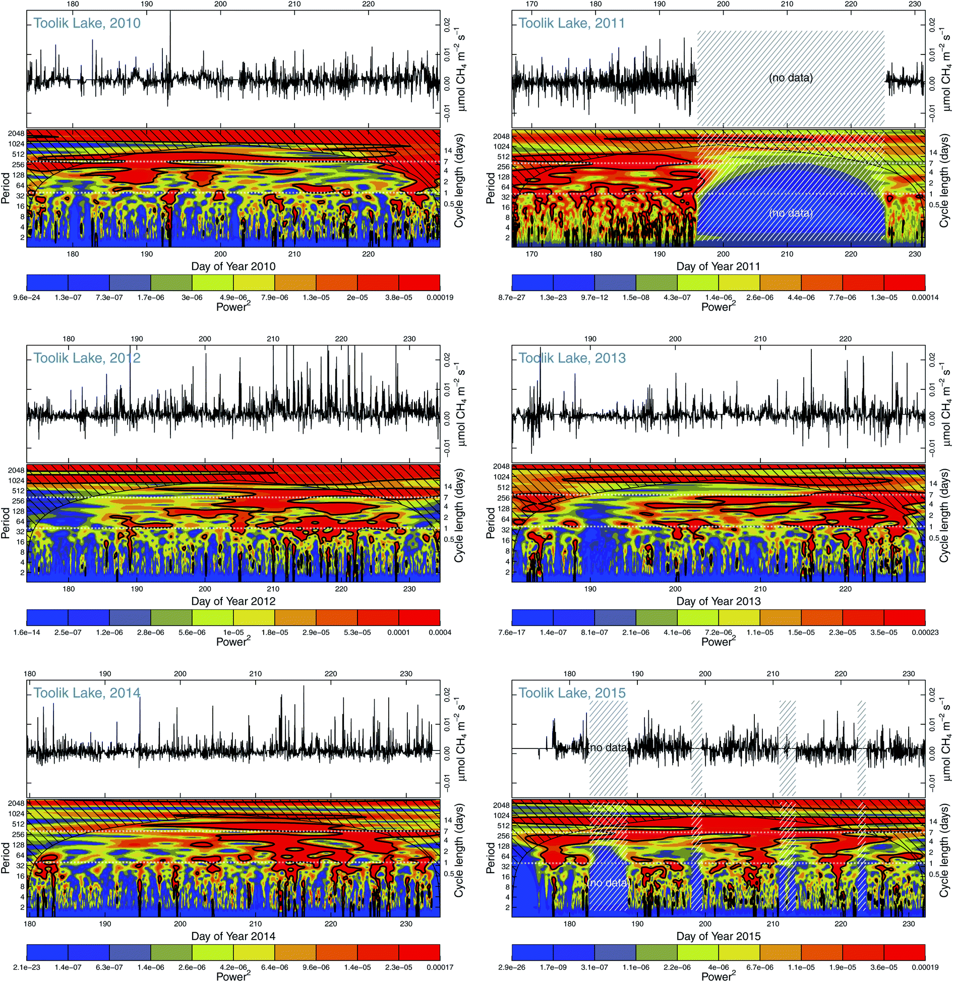 | ||
| Fig. 3 Morlet wavelet periodograms of CH4 fluxes during the ice-free periods 2010–2015. The time series of 30 minute fluxes are shown in the top part of each panel, and the Morlet wavelet decomposition below it. The black hashed areas are affected by the boundary conditions of the transformation and should be ignored. White hashed areas show major data gaps. Solid contours show features significant at the 95% level (p < 0.05). Horizontal white dashed lines show daily and weekly cycle lengths (right axis). | ||
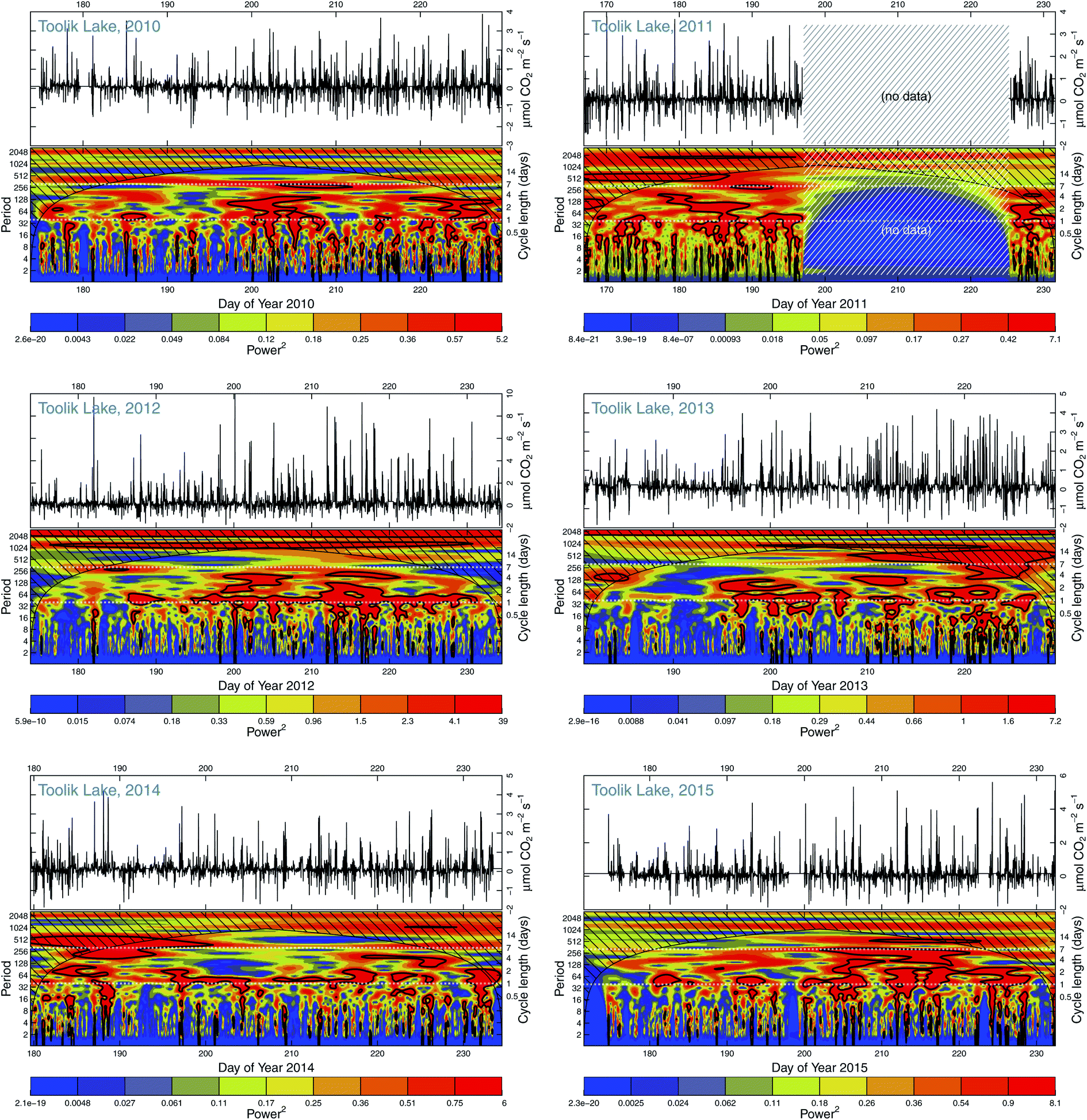 | ||
| Fig. 4 Same as in Fig. 3, but for CO2 fluxes. | ||
During all summers the diel cycle is often—but not always—pronounced over several days and significantly different from random variations. In years 2012, 2013, and 2014 the diel cycle in CH4 fluxes was more persistent in the second half of the ice-free period than in the first half. Contrastingly, years 2010 and 2015 have periods of several days with persistent diel cycles, which were interrupted by periods without diel cycles. In the special case of year 2015, several instrument failures in the CH4 flux measurements (hashed areas in Fig. 3) make interpretation more difficult (see Section 2.8), but these failures were always related to thunderstorms at the end of fair weather periods; thus, it is not unlikely that the significant diel cyclicity was restricted to the periods covered with data. CO2 fluxes were less affected by these storms than CH4, but the CO2 fluxes do not show a substantially different pattern in 2015 than the CH4 fluxes.
In the case of CO2 fluxes (Fig. 4) the diel cycles are even more pronounced than those of CH4 fluxes (Fig. 3). The fraction of the measurements with a significant diel cycle is always higher in a pairwise comparison of years (Fig. 5). Contrastingly, cycles on the order of the weekly cycle were clearly more pronounced in the CH4 fluxes than CO2 fluxes in all years. Given the short ice-free period of Toolik Lake that typically only lasts for 1.5–2.5 months, these multi-week cycles are a major portion of the ice-free summer period; therefore, we focus on the diel and ice-free summer cycles of gas effluxes from the lake.
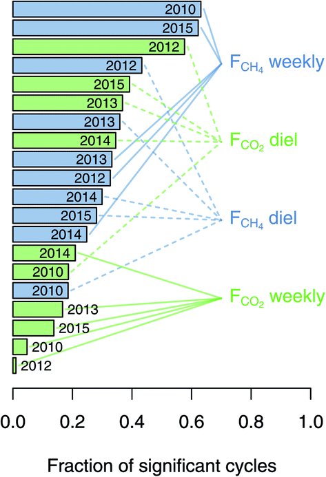 | ||
| Fig. 5 Fraction of the time period covered in each year shown in Fig. 3 and 4 during which the diel or weekly cycle of the CH4 and CO2 fluxes were significant at p < 0.05. | ||
3.2 Diel cycles of CH4 and CO2 effluxes
The diel cycles of both CH4 (Fig. 6) and CO2 (Fig. 7) were pronounced in all years, with 2015 being an exception in case of CH4 fluxes (Fig. 6f). The diel peak of the hourly median flux (circles in Fig. 6 and 7) of CH4 typically occurred between 2 and 6 hours in the morning (Alaska Daylight Time, AKDT) and 2 to 5 hours AKDT in case of CO2 efflux; thus the peak fluxes are synchronous with the lowest solar angle (around 2 hours AKDT) or the first hour after local solar minimum. Recall that the sun does not set at this northern location in the months of June and July, and only shortly disappears below the horizon in August.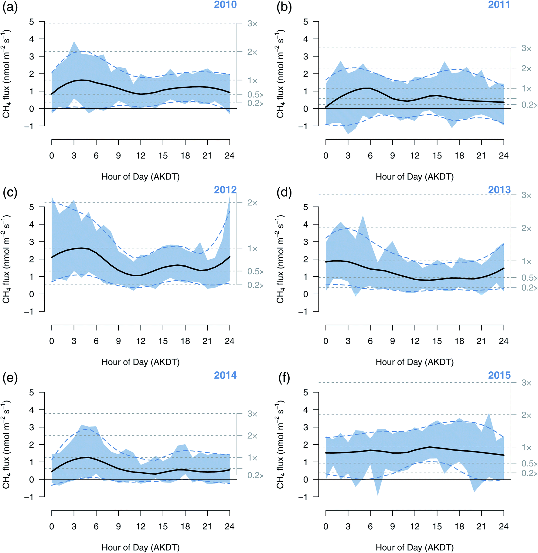 | ||
| Fig. 6 Median diel cycles of CH4 flux during each ice-free period 2010–2015 (a–f). Circles show the median flux for each hour of day. The blue area is the inter-quartile range (25–75% confidence interval for each hour of day). The black solid and blue dashed lines are smoothed fits to the medians and the boundaries of the inter-quartile range, respectively. Gray dotted lines show the levels of relative fluxes where 1× is defined by the maximum of the black solid spline fit to the hourly medians. | ||
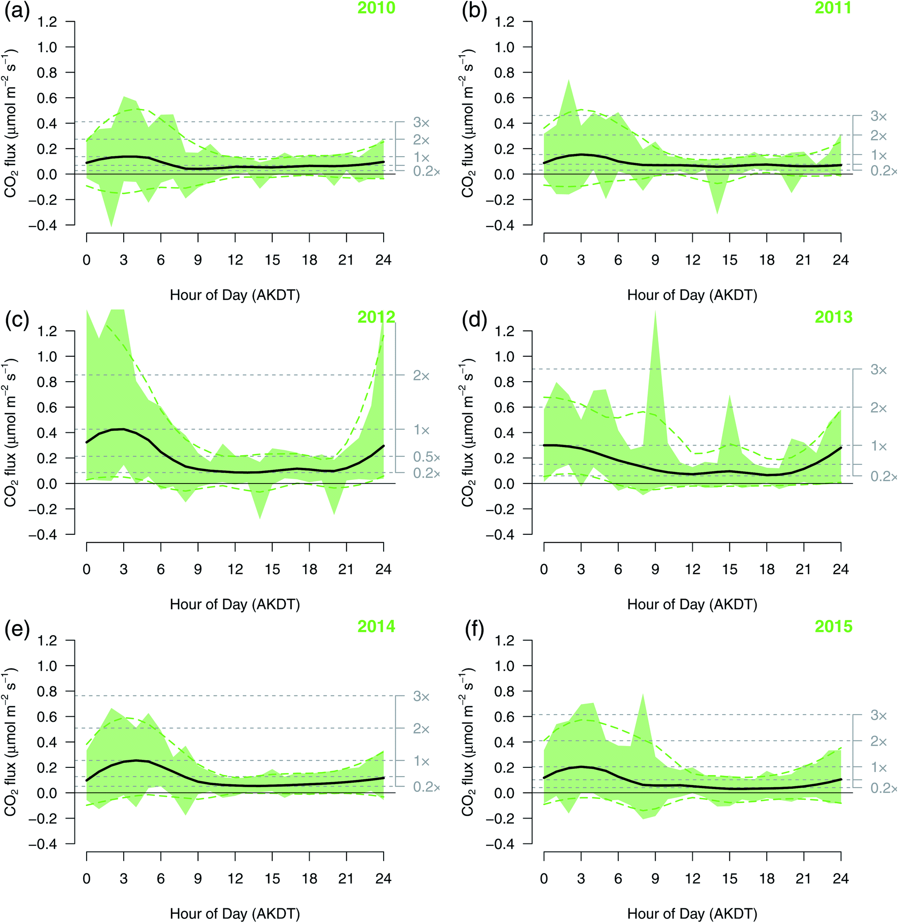 | ||
| Fig. 7 Same as in Fig. 6, but for CO2 flux. | ||
The highest daytime hourly median CH4 effluxes tend to be around 50% of nighttime fluxes (down to 20% in 2014; Fig. 6e), but only around 20% in the case of CO2 effluxes (Fig. 7). The day-to-day variability, however, is substantial for both gases, as is indicated by the color bands showing the inter-quartile range for each hour of day in Fig. 6 and 7. While this day-to-day variability within each hour of day only shows a weak relationship with the absolute CH4 flux magnitude, this is not the case for CO2 fluxes, where nocturnal variability is clearly higher than daytime variability (Fig. 7).
3.3 Ice-free summer periodicities of CH4 and CO2 effluxes
The ice-free summer periodicities of both CH4 and CO2 fluxes show a similar periodicity with timescales of about a week or longer (Fig. 8 and 9; the spacing between date labels is two weeks), which is in agreement with the Morlet wavelet periodograms (Fig. 3 and 4). There is, however, no consistent trend across all years. Only in the case of CO2 fluxes did the within-day variability (illustrated by the shading around each median flux) increase during some years (2012, 2013, Fig. 9c and d), but not so much in other years (2014, 2015, Fig. 9e and f).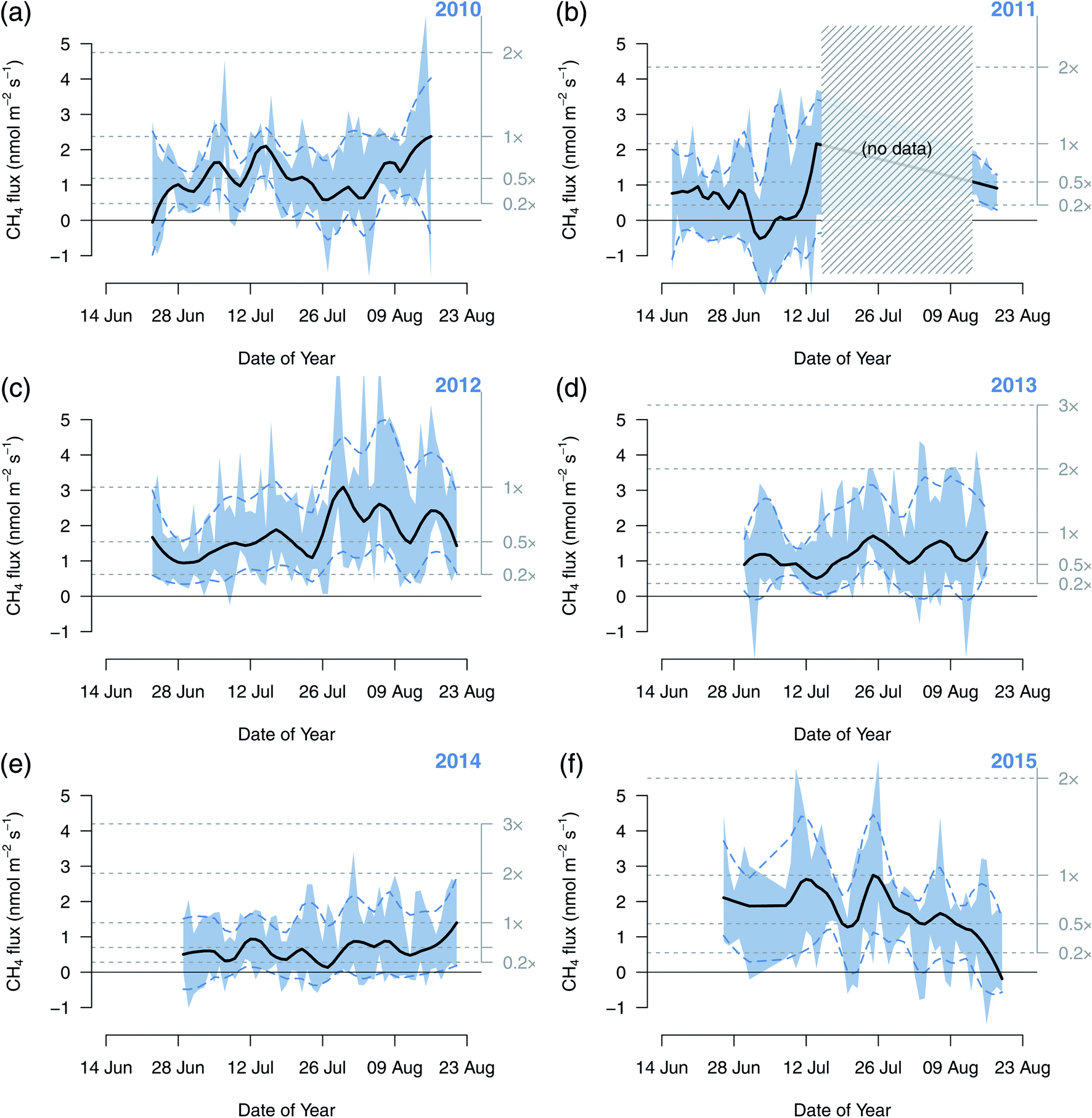 | ||
| Fig. 8 Median ice-free summer cycle of CH4 flux during each ice-free period 2010–2015 (a–f). Circles show the median flux for each hour of day. The blue area is the inter-quartile range (25–75% confidence interval for each hour of day). The black solid and blue dashed lines are smoothed fits to the medians and the boundaries of the inter-quartile range, respectively. Gray dotted lines show the levels of relative fluxes where 1× is defined by the maximum of the black solid spline fit to the hourly medians. | ||
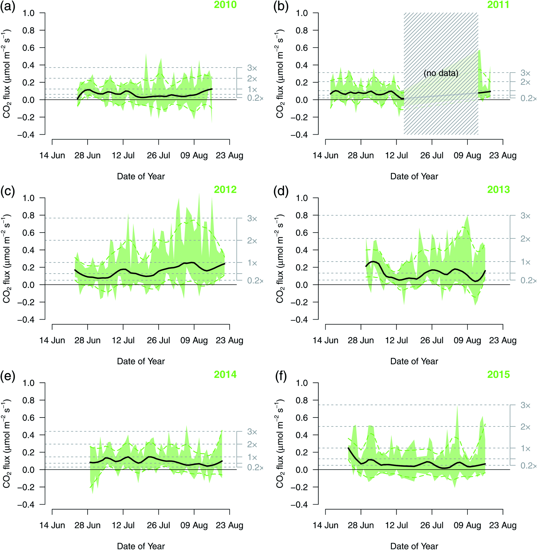 | ||
| Fig. 9 Same as in Fig. 8, but for CO2 flux. | ||
Daily median CH4 effluxes started with low magnitudes at the beginning of the summer season in 2010 and ended with the highest efflux when the equipment had to be removed from the lake (Fig. 8a). Contrastingly, in 2015 the daily median CH4 efflux started at a high level of around 2 nmol m−2 s−1 at the beginning of the ice-free period but ended almost neutral (Fig. 8f). In 2014, CH4 effluxes were generally low with a slight increase towards the end of the ice-free period (Fig. 8e).
When all available flux measurements from all six summers 2010–2015 are combined (Fig. 10), the median diel cycle shows a 2-fold and a 4-fold difference between nighttime high and daytime low fluxes for CH4 and CO2, respectively. Contrastingly, the median summer cycle shows an increasing trend of CH4 fluxes in the first half of the ice-free period followed by almost constant daily median fluxes (Fig. 10b). A reversed pattern was observed in CO2 fluxes with daily median fluxes being almost constant until the last week of the ice-free period when instruments were operated on the lake (Fig. 10d), during which an upward trend can be seen. In both cases, the early-season to late-season differences remained within a 2-fold range, similar to the diel cycle observed in CH4 fluxes, but clearly less pronounced than the observed diel cycle in CO2 fluxes. Also important to note is that median fluxes for both gases at all scales were positive, indicating a persistent efflux from the lake over the ice-free period.
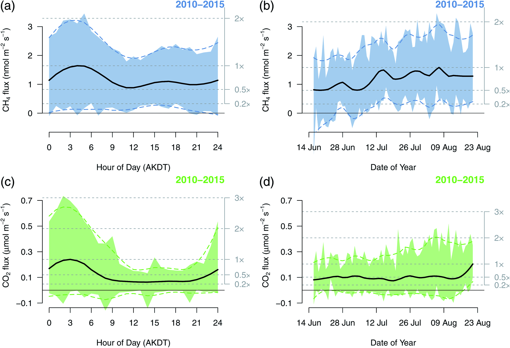 | ||
| Fig. 10 Median diel (left; a and c) and ice-free summer (right; b and d) cycles combined with all data from all summers 2010–2015. For the seasonal cycles only days with full data coverage were considered. Circles show the median flux for each hour of day (left) or day of year (right). The blue and green areas are the inter-quartile range (25–75% confidence interval for each hour of day or day of year). The black solid and colored dashed lines are smoothed fits to the medians and the boundaries of the inter-quartile range, respectively. Gray dotted lines show the levels of relative fluxes where 1× is defined by the maximum of the black solid spline fit to the hourly or daily medians. | ||
3.4 Ice-free mean fluxes and interannual variations
For reference with earlier literature based on discrete chamber flux measurements from Toolik Lake, the daily aggregated fluxes shown in Fig. 8 and 9 were averaged to daily means for each year (Fig. 11). Although robust statistics (using medians and quantiles) is helpful for interpreting noisy data such as eddy covariance flux estimates, most existing studies assume that such variations are normally distributed around a mean value and thus report arithmetic mean and standard deviation. In Fig. 11 the bar size corresponds to the arithmetic mean, and whiskers show ±1 SD. For comparison with the data presented in Fig. 8 and 9, the ice-free summer interquartile ranges and median fluxes were added with a darker or brighter colored box and a white circle, respectively.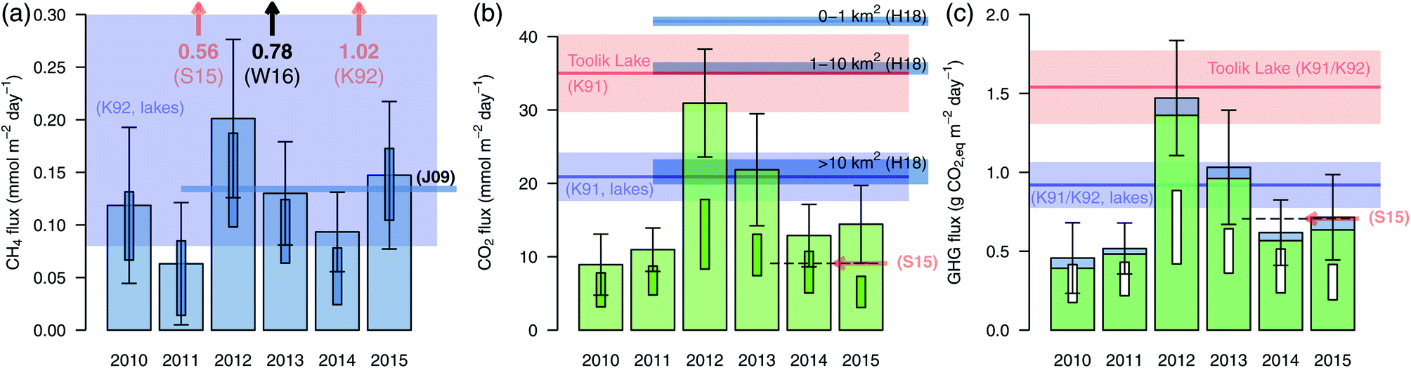 | ||
| Fig. 11 Average daily fluxes of (a) CH4, (b) CO2, and (c) global warming potential (in CO2-equivalents) during each ice-free periods 2010–2015 of Toolik Lake. Bars show the ice-free mean with standard deviation as vertical whiskers. The darker boxes show the inter-quartile ranges (first to third quartile) of daily medians shown in Fig. 8 and 9, and their median is shown as a white circle. The bluish and reddish bold lines (mean values) and color bands (±SD) show the ranges given by Kling et al. (K91)5 for Toolik Lake (red color) and (K92)60 for all lakes (blue color). The more recent estimates for Toolik Lake presented by Sepulveda et al. (S15)61 (orange arrows; diffuse flux only, because we did not observe ebullition) and a CH4 flux estimate by Wik et al. (W16)15 (black arrow; diffuse flux only for glacial and post-glacial lakes north of 50°N) are also shown for reference. The global estimate of CH4 fluxes of Juutinen et al. (J09),74 and the CO2 flux estimates of all boreal lakes from Hastie et al. (H18)66 are shown with dark blue bars. H18 presents estimates for small (≤1 km2), middle (1–10 km2; Toolik Lake size class), and large lakes (>1 km2), which are shown separately in panel (b). An additional earlier CH4 flux estimation is available from 14 July 1990 (red K92),60 which is far outside the range presented in panel (a). | ||
While variability during the ice-free period was quite comparable among years in both CH4 and CO2 fluxes (Fig. 11a and b), considerable interannual variation was found, with a 3 to 4-fold difference between the year with the highest and lowest fluxes of both CH4 and CO2. Yearly magnitude trends between CO2 and CH4 did not match, except for the fact that maximum emissions occurred in 2012 for both gases. The mismatch in overall trend thus indicates that CH4 and CO2 fluxes were governed by different physical and chemical processes. In addition, all fluxes observed over Toolik Lake were likely diffusive, as no ebullition was detected during a sonar field campaign to detect bubbles that occurred in July 2012 (see ESI†) when CH4 concentrations were highest (Fig. 10b and 11a). Only a few features recorded during one of the three July 2012 sonar campaigns could potentially be bubble plumes, but the results are not conclusive (see ESI†). The features were not associated with any single bubble tracks, which is typically the case.51,53 Because no single bubble tracks were observed, we could not make any estimations on the potential flux from these features if they were indeed plumes.
When converting both trace gas fluxes to global warming potentials (GWP) in units of g CO2,eq m−2 on a 100 year timescale (Fig. 11c and Table 1), it becomes clear that it is primarily the CO2 efflux from Toolik Lake that dominates the GWP, contributing 86–93% to the lake's GWP.
Plotting cumulative fluxes for both trace gases over the ice-free periods requires some interpolation of the larger data gaps. Fig. 12 shows that years with almost complete data coverage show no signs of special singular events, such as deep mixing from storms that might lead to short-term emission peaks. The changes in slope of each cumulative curve indicate the ice-free emission cycle with minor modifications due to diel fluctuations. In relation to the variation of median diel fluxes the interannual variations were a factor 4.1 and 1.8 larger for CH4 and CO2 fluxes, respectively. Hence, using the yearly averages presented in Fig. 11a and b for interpolating longer data gaps (shown with thin dashed lines in Fig. 12) can be considered a valid approach to obtain ice-free totals for each year.
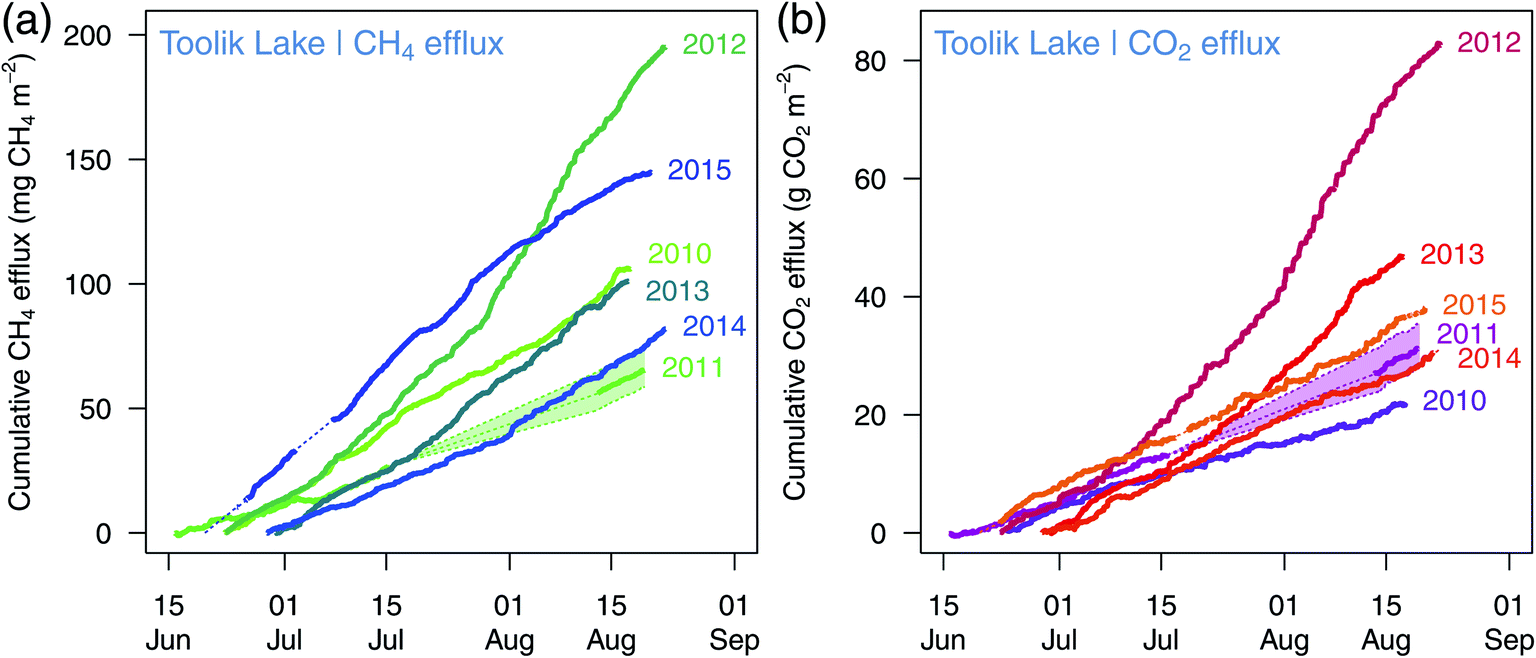 | ||
| Fig. 12 Cumulative fluxes of (a) CH4 and (b) CO2 during the ice-free periods 2010–2015 when flux instruments were active on the lake. Ice-off and refreezing were typically one to two weeks before and after instruments could be operated on the lake. A ±30% uncertainty range was added to the 2011 data due to the large data gap. | ||
4 Discussion
These are the first eddy covariance flux measurements from multiple ice-free summers of a deep lake in the low Arctic. They are a follow-up to the pioneering EC measurements made over Toolik Lake in years 1994 and 1995,11 which only quantified short-term CO2 fluxes and not CH4 emissions.4.1 Short-term periodicities in CH4 and CO2 fluxes
As described in Section 2.8, instrument failures and wave motion did not contribute to periodicities in the EC flux data. Both CH4 and CO2 showed significant periodicities at shorter time scales than the diel timescale as seen in Fig. 3 and 4, namely in the lowest part of the Morlet periodograms with periods <8 that correspond to cycle lengths of <4 hours at 30 minute resolution. We consider these periods to be related to the artefact that eddy covariance flux measurements are typically averaged over fixed clock-based intervals of 30 minutes. In reality, eddies of any size do not respect these artificial boundaries between averaging time intervals, and thus often a strong deviation in one direction is counterbalanced at least in part by a deviation in the other direction in the following averaging interval. Such variations are not noise and not random variations, hence they are correctly identified as significant variations, but they basically indicate that depending on atmospheric conditions the turbulent time scale in the atmosphere is on the order of 1 h during daytime to 4 h during the night. This problem is well known from EC flux measurements above tall canopies.54,55 This is also the reason why individual 30 minute periods of EC measurement can show a flux < 0 μmol m−2 s−1 due to such artefacts. For example, Fig. 6b shows a relevant share of negative CH4 fluxes in 2011, although on average CH4 evades from the water body to the atmosphere.4.2 Diel cycles of CH4 and CO2 fluxes
In contrast to land surfaces, a lake surface is warmer than the atmosphere at night during the ice-free period, and thus convective conditions dominate at night but much less so during the day (Fig. 13b) when the lake surface often is colder than the atmosphere above.29 Thus, in contrast to EC flux measurements over land, there is rarely an issue with stagnant air and stable stratification of the atmosphere at night.29 Therefore, nocturnal EC flux measurements can be considered at least as reliable as daytime measurements when measurement instruments are placed on the lake such that the measurement footprint lies entirely over the lake surface and influence from land is minimal.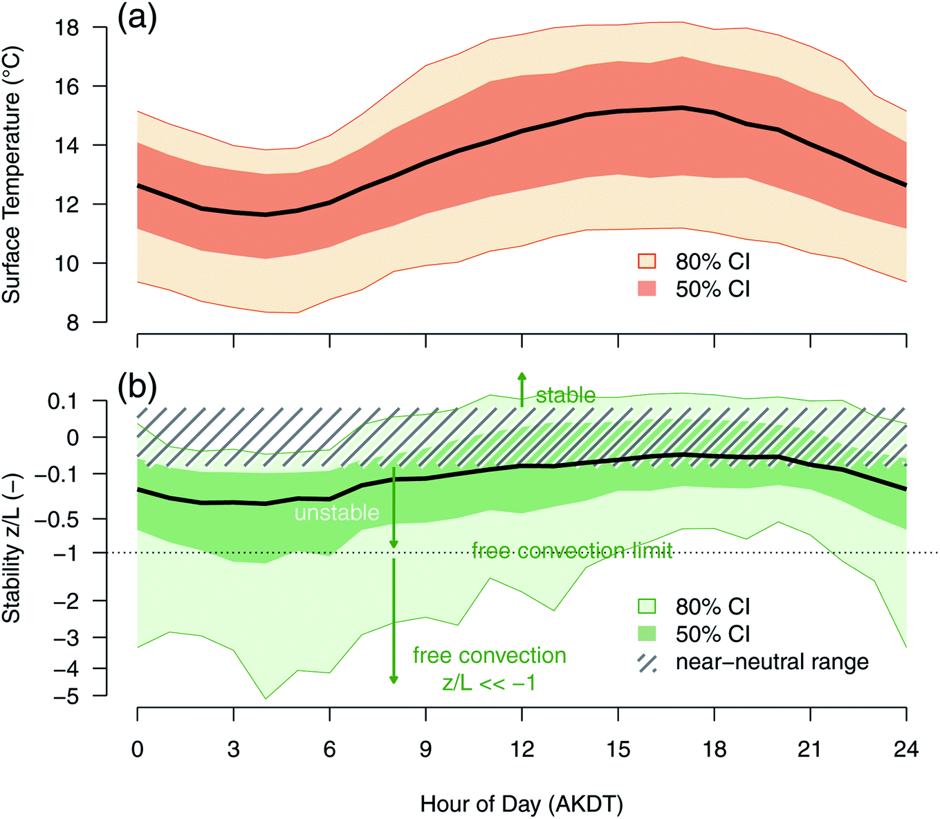 | ||
| Fig. 13 Diel course of (a) lake surface temperature, and (b) atmospheric stability z/L (Monin–Obukhov stability parameter44). Measurements from all seasons 2010–2015 were aggregated by hour of day. The range between the 10th and 90th percentile (80% confidence interval, CI) and the inter-quartile range (50% CI) are shown with color bands, and the bold line shows the median value. Stability values in the range −0.0625 < z/L < 0.0625 show near-neutral stability,75 whereas positive z/L indicate stable stratification of the atmosphere, and negative z/L unstable and convective conditions. Free convection exists if z/L = −1, forced convection is found under unstable conditions but with z/L ≥ −1. | ||
Peak effluxes of CH4 (Fig. 6) and CO2 (Fig. 7) tended to occur during the night in most years. Night in this context means the period with low solar elevation angle, but it does not mean that it was very dark. The diel cycles of CO2 fluxes, which have also been observed elsewhere,56,57 are in agreement with the interpretation presented in Eugster et al. (2003)11 that the enhanced nocturnal CO2 effluxes may at least in part be related to the mixing of CO2-rich waters from the deeper layers to the lake surface, although a decrease in photosynthetic uptake at night may also be important. The enhancement of nocturnal CO2 effluxes is most prominently seen in the 2012 ice-free period (Fig. 7c), but occurs in most years. A diel cycle of CO2 flux with nocturnal flux peaks was also observed in a long-term study from Lake Valkea-Kotinen, a boreal lake in southern Finland,58 but contrasts with observations from another boreal lake in Finland, where EC measurements did not show a diel cycle in CO2 flux, but only in the CH4 fluxes.25
A diel cycle of CH4 fluxes is also seen at Toolik Lake, but it was clearly less pronounced than that of CO2, even in 2012 (Fig. 6c) with the highest median and peak CH4 effluxes of all six ice-free periods investigated. The daily range of median fluxes is typically on the order of 2× for CH4 fluxes (Fig. 6) but on the order of 4× for CO2 fluxes (Fig. 7). The timing of the peak effluxes coincides with the hours of day when the surface cooling of the water is strongest and promotes convection59 (Fig. 13). The relative contributions of both processes will need an in-depth assessment that would go beyond the scope of this paper.
The evidence of a pronounced diel cycle of CH4 and CO2 effluxes (summarized for all summers in Fig. 10a and c) indicates that when discrete sampling with other techniques is done over such lakes, careful considerations about time of day when measurements are taken are required; for example, if sampling is always done during the day then efflux estimates may be conservative (i.e., Kling et al.5,60). Alternatively, measurements carried out at a consistent time of day would allow to scale up to daily values. This approach is complicated by the fact that not all summers showed pronounced diel cycles as were observed in 2012; e.g., the diel cycle of CH4 fluxes was almost nonexistent in 2015. In contrast, the diel cycle of CO2 fluxes showed similar ratios of the maximum vs. minimum median fluxes (indicated by the factor given on the right-hand axis in Fig. 7), but with year-specific absolute amplitudes.
4.3 Ice-free summer periodicities of CH4 and CO2 effluxes
While the diel cycles of both CH4 and CO2 effluxes showed a relatively clear and simple pattern, the yearly ice-free cycles observed are more difficult to generalize. The years with almost complete data coverage (2010, 2012–2015; Fig. 8 and 9) as well as the Morlet periodograms (Fig. 3 and 4) indicate that the entire ice-free fluxes for each year can be estimated well even if there are breaks in the continuous EC measurements. In other words, the variation over the ice-free period is low enough that weekly sampling that accounted for the diel cycles could provide a defensible ice-free summer flux estimate.Based on our direct flux measurements we estimated that 86–93% of the lake's GWP is due to CO2 fluxes, thus only 7–14% originating from CH4. A recent study by Sepulveda-Jauregui et al.61 estimated that roughly 65% of typical non-yedoma lakes' GWP stems from CH4 fluxes. This discrepancy indicates that future studies should address why direct flux measurements (via EC) differ so strongly from flux calculations (i.e., piston velocity modeling) based on discrete sampling, which may have better spatial coverage but always a lower temporal resolution than EC flux measurements.
4.4 Estimating fluxes from summer measurements
In general, ebullition could be a significant emission pathway during ice-melt or freeze-up considering bubbles have been observed in iced-over lakes of the north.62 A previous study of 40 Alaskan lakes61 reported an ebullition estimate for Toolik Lake based on ice surveys, but no other specifics on location or degree of ebullition was given. We, on the other hand, did not observe any ebullition via our 2012 sonar survey in Toolik and have no evidence that ebullition is a significant CH4 emission pathway in this lake, even during ice-melt or freeze-up (T. DelSontro, pers. comm.). Ebullition is typically most prevalent during the warmest part of the summer as production rates are temperature-dependent and emissions scale with temperature.63 Lake depth and sediment temperature of Toolik are however not independent variables due to the presence of permafrost that helps keep lake bottom temperatures below 5–6 °C throughout the summer, which thereby limits the decomposition of organic matter in sediments in deeper locations.64 The continuous EC measurements during multiple ice-free periods at Toolik, however, did not reveal any CH4 emission events (detected by our 30 minute averaging period) that would suggest ebullition occurred, as has been observed elsewhere.21 However, if ebullition is occurring frequently via small bubbles, then the wavelet-based method suggested by Iwata et al. (2018)65 might help to quantify the ebullition contribution after a thorough validation of the applicability of this method to lakes where ebullition is very obvious; however, this might be challenging for Toolik Lake data where ebullition is not obvious.In the case of CO2 flux, however, using the available data to extrapolate to summer totals might be an underestimate because we missed the few days after removal of EC instrumentation but before the onset of ice cover (see Table 1). Within these limitations, which are the same as those of all other studies of flux measurements in the Arctic, it can be assumed that the available data provide a sound basis for estimating total gas losses from Toolik Lake, and to quantify its global warming potential during the ice-free summers.
4.5 Ice-free mean fluxes and interannual variations
Earlier estimates of CO2 efflux from Toolik Lake (red range in Fig. 11b) and open waters globally5,66 (blue range in Fig. 11b) provide a reference for EC fluxes measured during the 2010–2015 ice-free summers. A statistically more elaborate recent estimate by Hastie et al.66 for boreal lakes of various sizes provides similar estimates for CO2 fluxes (Fig. 11b), of which Toolik falls into the 1–10 km2 size range. While 2012 was almost reaching earlier estimates for Toolik Lake and 2013 matched the range given for all lakes by Kling et al. (1991),5 five out of six years clearly showed lower CO2 effluxes than earlier estimates for Toolik Lake. Few CH4 flux estimates for Toolik exist for comparison with our CH4 results. One estimate from 1990 (ref. 60) (1.02 mmol m−2 d−1; Fig. 11a), and a 2011–2012 estimate from another study61 (1.25 and 0.56 mmol CH4 m−2 d−1 for total and diffusive fluxes, respectively, assuming 100 days of ice-free conditions in summer; Fig. 11a) were much higher than what we observed with continuous EC measurements, although it should be noted that substantial differences between direct (EC) and indirect (headspace, chamber) flux measurement methods still exist. Contrastingly, the CO2 flux estimates from the same studies were of the same order of magnitude as ours (35.0 ± 5.3 and 9.1 mmol CO2 m−2 d−1, respectively; Fig. 11b). These previous studies, however, were based on only one or a few measurements of the headspace equilibration method using dissolved gas concentrations combined with a surface flux model (e.g., Kling et al.60) and thus lack the temporal and spatial resolution that a summer of EC measurements provides.A comparison of the ice-free flux density estimates from 2010–2015 with similar estimates obtained from 1977–1989 (ref. 60) but with a very low number of samples (N = 2 to 11 per summer from 1975 to 1989, Fig. 14) shows a broad overlap of two rather different methods: (1) EC for the 2010–2015 data and (2) headspace equilibration in combination with a gradient-flux model for the 1975–1989 data.60 Only the exceptional years 1977 and 1978 indicate much higher CO2 effluxes than those observed in any of the EC years 2010–2015. However, in early August 2012 and 2013 the 3rd quartile of EC flux measurements of several days (Fig. 9c and d) was of the same order of magnitude as CO2 fluxes reported from 1977 and 1978,60 indicating that some of the earlier reported interannual variability may be an artefact of the lack of continuous observations when discrete sampling is used. In other words, the main advantage of EC flux measurements is the better temporal coverage of dynamic processes that show diel, weekly, and interannual variations as compared to random sampling with low numbers of samples.
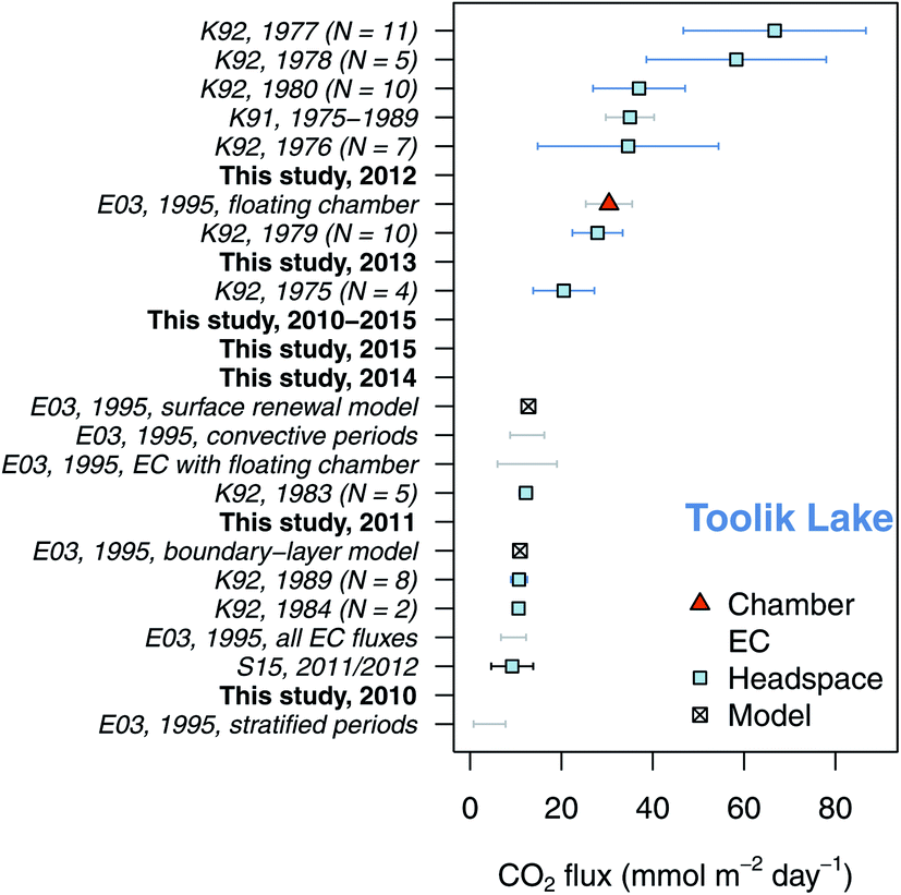 | ||
| Fig. 14 Comparison of CO2 fluxes measured during the ice-free periods 2010–2015 (bold symbols, bold font, black whiskers) with estimates from earlier publications (means ± SD): Kling et al. (1991; K91),5 Kling et al. (1992; K92),60 Sepulveda-Jauregui et al. (2015; S15),61 and Eugster et al. (2003; E03).11 | ||
When the additional global warming potential of CH4 fluxes from Toolik Lake are added to CO2 flux measurements (Fig. 11c) the overall interpretation changes little as CO2 remains the dominant climate-relevant gas flux from Toolik Lake to the atmosphere. In other words, while summer CH4 emissions did vary annually by a factor of 4 (Fig. 11a), they were too low to rival CO2 emissions when converted to CO2-equivalents. Other studies in boreal and Arctic regions have found, however, that aquatic CH4 emissions can significantly change the overall global warming potential of a system.9,67 These studies found that CH4 fluxes were driven by sediment temperature, depth and oxygen67 or soil organic matter (SOM) erosion.9 Sediment temperatures, however, remain below 5–6 °C throughout the summer, which is the typical temperature observed at the bottom of the lake. Thus, the role of lake temperature, oxygen or depth controlling the interannual variability in CH4 flux may be limited at Toolik Lake because little change in lake temperature or oxygen has been observed from 2010 to 2015,68 if we assume that conditions in 2010–2015 were similar to the earlier observations reported by Hobbie and Kling.68 However, recent studies have suggested that inputs from the active layer water may be more important than internal production.69,70
As for SOM, Toolik Lake is a glacial lake with negligible amounts of SOM erosion observed around the lake shore (Hobbie and Kling,68 and pers. observation), and thus the comparatively low CH4 effluxes from Toolik would be expected. Seeing as CH4 ebullition tends to be stochastic and higher in emission than diffusion when it does occur, its presence could cause annual variability in overall fluxes. However, we found no evidence for CH4 ebullition via the sonar survey and the EC method that would capture ebullition events adequately, as in Schubert et al.21 In Toolik Lake, our placement of the EC platform in 12 m of water was assumed to be representative of average lake conditions of the >85% of the lake with depth > 2 m (see Fig. 2), and thus on the basis of a lack of clear ebullition events and a lack of CH4 bubbles observed in the water column, we suggest that ebullition plays a negligible role in the variability of CH4 and overall GHG effluxes at any frequency in Toolik Lake. However, potential flux peaks during the disappearance of the ice71 or related to vernal or autumnal lake turnover72 might be underestimated in our ice-free flux estimate in Table 1, and thus future studies should try to extend the measurements beyond the period when an EC system can safely be operated on a seasonally ice-free Arctic lake. It should also be noted that if episodic events were not detected during six years of seasonal deployment of our EC system, this does not imply that such events never occur. Our measurements represent lake depths > 2 m, and thus if such episodic events such as ebullition with much stronger fluxes should occur in the shallower areas of the lake (<2 m, 11.3% of the total lake surface; Fig. 2), then our ice-free estimates presented in Table 1 would be conservative with respect to the overall flux magnitude.
5 Conclusions
Six summers of eddy covariance CH4 and CO2 flux measurements on Toolik Lake indicated that earlier estimates of CO2 efflux based on other techniques (floating chambers, gas concentration gradients) were mostly yielding the correct order of magnitude, despite the small number of samples that were taken. We found that interannual variability in gas fluxes was larger than the median diel variability of fluxes, by on average factor 4.1 for CH4 and factor 1.8 for CO2.Due to lack of ebullition and the absence of large effluxes from episodic events during the ice-free periods, 86–93% of the global warming potential of Toolik Lake is due to CO2 effluxes from the lake, with CH4 effluxes only playing a minor role. To improve our understanding of how deep glacial lakes in the Arctic might respond to climate change, future studies should carefully investigate the drivers of the diel cycle of CH4 and CO2 fluxes, the trends during the ice-free period, and what drives the large interannual differences. Moreover, new approaches should be found to measure fluxes also during the critical period of ice-off and ice-on, when technical constraints limit direct measurements on the lake.
Data availability
The data used in this study can be downloaded from the Environmental Data Initiative (EDI) portal via DOI: 10.6073/pasta/919cd028d73ef4f8427d951148f974ec.Conflicts of interest
The author declare no conflicts of interest.Acknowledgements
We acknowledge support received from the Arctic LTER grants NSF-DEB-1637459, 1026843, 1754835, NSF-PLR 1504006, and supplemental funding from the NSF-NEON and OPP-AON programs. W. E. acknowledges additional funding received from ETH Zurich scientific equipment grants 0-43350-07 and 0-43683-11. James Laundre is thanked for technical support, Jason Dobkowski for supervising deployment and removal of the float to and from the lake, and Randy Fulweber for his GIS support. Many thanks also go to Toolik Field Station staff members for support.References
- E. A. G. Schuur, A. D. McGuire, C. Schädel, G. Grosse, J. W. Harden, D. J. Hayes, G. Hugelius, C. D. Koven, P. Kuhry, D. M. Lawrence, S. M. Natali, D. Olefeldt, V. E. Romanovsky, K. Schaefer, M. R. Turetsky, C. C. Treat and J. E. Vonk, Nature, 2015, 520, 171–179 CrossRef CAS.
- Z. Tan and Q. Zhuang, Environ. Res. Lett., 2015, 10, 054016 CrossRef.
- C. D. Elder, M. Schweiger, B. Lam, E. D. Crook, X. Xu, J. Walker, K. M. W. Anthony and C. I. Czimczik, J. Geophys. Res.: Biogeosci., 2019, 124, 1209–1229 CrossRef CAS.
- C. D. Elder, D. R. Thompson, A. K. Thorpe, P. Hanke, K. M. W. Anthony and C. E. Miller, Geophys. Res. Lett., 2020, 47, e2019GL085707 CrossRef CAS.
- G. W. Kling, G. W. Kipphut and M. C. Miller, Science, 1991, 251, 298–301 CrossRef CAS.
- A. S. Hope, L. L. Coulter and D. A. Stow, Int. J. Remote Sens., 1999, 20, 829–835 CrossRef.
- A. D. McGuire, L. G. Anderson, T. R. Christensen, S. Dallimore, L. Guo, D. J. Hayes, M. Heimann, T. D. Lorenson, R. W. Macdonald and N. Roulet, Ecol. Monogr., 2009, 79, 523–555 CrossRef.
- B. Riordan, D. Verbyla and A. D. McGuire, J. Geophys. Res.: Biogeosci., 2006, 111, G04002 Search PubMed.
- K. Walter Anthony, R. Daanen, P. Anthony, T. S. von Deimling, C.-L. Ping, J. P. Chanton and G. Grosse, Nat. Geosci., 2016, 9, 679–682 CrossRef CAS.
- G. Myhre, D. Shindell, F.-M. Bréon, W. Collins, J. Fuglestvedt, J. Huang, D. Koch, J.-F. Lamarque, D. Lee, B. Mendoza, T. Nakajima, A. Robock, G. Stephens, T. Takemura and H. Zhang, in Climate Change 2013: The Physical Science Basis. Contribution of Working Group I to the Fifth Assessment Report of the Intergovernmental Panel on Climate Change, ed. T. F. Stocker, D. Qin, G.-K. Plattner, M. Tignor, S. K. Allen, J. Boschung, A. Nauels, Y. Xia, V. Bex and P. M. Midgley, Cambridge University Press, Cambridge, United Kingdom and New York, NY, USA, 2013, ch. Anthropogenic and Natural Radiative Forcing, pp. 129–234 Search PubMed.
- W. Eugster, G. Kling, T. Jonas, J. P. McFadden, A. Wüest, S. MacIntyre and F. S. Chapin III, J. Geophys. Res., 2003, 108, 4362–4380 CrossRef.
- K. M. Walter, S. A. Zimov, J. P. Chanton, D. Verbyla and F. S. Chapin III, Nature, 2006, 443, 71–75 CrossRef CAS.
- T. R. Christensen, Nature, 2014, 509, 279–281 CrossRef.
- M. Jammet, P. Crill, S. Dengel and T. Friborg, J. Geophys. Res.: Biogeosci., 2015, 120, 2289–2305 CrossRef CAS.
- M. Wik, R. K. Varner, K. W. Anthony, S. MacIntyre and D. Bastviken, Nat. Geosci., 2016, 9, 99–105 CrossRef CAS.
- A. Townsend-Small, F. Åkerström, C. D. Arp and K. M. Hinkel, J. Geophys. Res.: Biogeosci., 2017, 122, 2966–2981 CrossRef CAS.
- M. A. Holgerson and P. A. Raymond, Nat. Geosci., 2016, 9, 222–226 CrossRef CAS.
- C. D. Elder, X. Xu, J. Walker, J. L. Schnell, K. M. Hinkel, A. Townsend-Small, C. D. Arp, J. W. Pohlman, B. V. Gaglioti and C. I. Czimczik, Nat. Clim. Change, 2018, 8, 166–171 CrossRef CAS.
- M. Wik, B. F. Thornton, D. Bastviken, J. Uhlbäck and P. M. Crill, Geophys. Res. Lett., 2016, 43, 1256–1262 CrossRef CAS.
- E. Podgrajsek, E. Sahlée, D. Bastviken, J. Holst, A. Lindroth, L. Tranvik and A. Rutgersson, Biogeosciences, 2014, 11, 4225–4233 CrossRef.
- C. J. Schubert, T. Diem and W. Eugster, Environ. Sci. Technol., 2012, 46, 4515–4522 CrossRef CAS.
- S. Sollberger, B. Wehrli, C. J. Schubert, T. DelSontro and W. Eugster, Environ. Sci.: Processes Impacts, 2017, 19, 1278–1291 RSC.
- D. Bastviken, A. L. Santoro, H. Marotta, L. Q. Pinho, D. F. Calheiros, P. Crill and A. Enrich-Prast, Environ. Sci. Technol., 2010, 44, 5450–5455 CrossRef CAS.
- P. M. Crill, K. B. Bartlett, J. O. Wilson, D. I. Sebacher, R. C. Harriss, J. M. Melack, S. MacIntyre, L. Lesack and L. Smith-Morrill, J. Geophys. Res., 1988, 93, 1564 CrossRef CAS.
- K.-M. Erkkilä, A. Ojala, D. Bastviken, T. Biermann, J. J. Heiskanen, A. Lindroth, O. Peltola, M. Rantakari, T. Vesala and I. Mammarella, Biogeosciences, 2018, 15, 429–445 CrossRef.
- J. Jansen, B. F. Thornton, A. Cortés, J. Snöälv, M. Wik, S. MacIntyre and P. M. Crill, Biogeosciences, 2020, 17, 1911–1932 CrossRef.
- A. Cortés, S. MacIntyre and S. Sadro, Limnol. Oceanogr., 2017, 62, 2023–2044 CrossRef.
- W. Eugster and P. Plüss, Agric. For. Meteorol., 2010, 150, 841–851 CrossRef.
- T. Vesala, W. Eugster and A. Ojala, in Eddy covariance measurements over lakes, ed. M. Aubinet, T. Vesala and D. Papale, Springer, Dordrecht Heidelberg London New York, 2012, ch. 15, pp. 365–376 Search PubMed.
- M. Mauder, T. Foken, R. Clement, J. A. Elbers, W. Eugster, T. Grünwald, B. Heusinkveld and O. Kolle, Biogeosciences, 2008, 5, 451–462 CrossRef CAS.
- Eddy Covariance – A Practical Guide to Measurement and Data Analysis, ed. M. Aubinet, T. Vesala and D. Papale, Springer, Dordrecht Heidelberg London New York, 2012 Search PubMed.
- C. Rebmann, O. Kolle, B. Heinesch, R. Queck, A. Ibrom and M. Aubinet, in Data Acquisition and Flux Calculations, ed. M. Aubinet, T. Vesala and D. Papale, Springer, Dordrecht Heidelberg London New York, 2012, ch. 3, pp. 59–84 Search PubMed.
- T. Foken, R. Leuning, S. R. Oncley, M. Mauder and M. Aubinet, in Corrections and data quality control, ed. M. Aubinet, T. Vesala and D. Papale, Springer, Dordrecht Heidelberg London New York, 2012, ch. 4, pp. 85–131 Search PubMed.
- E. K. Webb, Bound.-Layer Meteorol., 1982, 23, 251–254 CrossRef.
- R. V. Hiller, C. Zellweger, A. Knohl and W. Eugster, Atmos. Meas. Tech. Discuss., 2012, 5, 351–384 CrossRef.
- F. G. Wienhold, H. Fischer and G. W. Harris, Infrared Phys. Technol., 1996, 37, 67–74 CrossRef CAS.
- W. Eugster, Proceedings of the Fourth International Conference on Fog, Fog Collection and Dew, La Serena, Chile, 2007, pp. 359–362 Search PubMed.
- W. Eugster and L. Merbold, Soil, 2015, 1, 187–205 CrossRef CAS.
- S. Osterwalder, W. Eugster, I. Feigenwinter and M. Jiskra, Atmos. Meas. Tech., 2020, 13, 2057–2074 CrossRef CAS.
- T. Foken, M. Göckede, M. Mauder, L. Mahrt, B. Amiro and W. Munger, in Post-field data quality control, ed. X. Lee, W. Massman and B. Law, Kluwer, Dordrecht, 2004, ch. 9, pp. 181–208 Search PubMed.
- C. Schaller, F. Kittler, T. Foken and M. Göckede, Atmos. Chem. Phys., 2019, 19, 4041–4059 CrossRef CAS.
- R. B. Stull, An Introduction to Boundary Layer Meteorology, Kluwer, Dordrecht, 1988 Search PubMed.
- S. P. S. Arya, Introduction to Micrometeorology, Academic Press, San Diego, 1988 Search PubMed.
- A. S. Monin and A. M. Obukhov, Tr. Geofiz. Inst., Akad. Nauk SSSR, 1954, 24, 163–187 Search PubMed.
- R Core Team, R: A Language and Environment for Statistical Computing, R Foundation for Statistical Computing, Vienna, Austria, 2019 Search PubMed.
- G. P. Nason, Wavelet Methods in Statistics with R, Springer, New York, 2008 Search PubMed.
- J. Morlet, G. Arens, E. Fourgeau and D. Giard, Geophysics, 1982, 47, 203–221 CrossRef.
- N. Kljun, P. Calanca, M. W. Rotach and H. P. Schmid, Bound.-Layer Meteorol., 2004, 112, 503–523 CrossRef.
- N. Kljun, P. Calanca, M. W. Rotach and H. P. Schmid, Geosci. Model Dev., 2015, 8, 3695–3713 CrossRef.
- L. C. Loken, J. T. Crawford, P. J. Schramm, P. Stadler, A. R. Desai and E. H. Stanley, J. Geophys. Res.: Biogeosci., 2019, 124, 2248–2266 CrossRef CAS.
- T. DelSontro, D. F. McGinnis, B. Wehrli and I. Ostrovsky, Environ. Sci. Technol., 2015, 49, 1268–1276 CrossRef CAS.
- W. Eugster and M. J. Zeeman, Int. Congr. Ser., 2006, 1293, 66–75 CrossRef CAS.
- T. DelSontro, M. J. Kunz, T. Kempter, A. Wüest, B. Wehrli and D. B. Senn, Environ. Sci. Technol., 2011, 45, 9866–9873 CrossRef CAS.
- J. J. Finnigan, R. Clement, Y. Malhi, R. Leuning and H. A. Cleugh, Bound.-Layer Meteorol., 2003, 107, 1–48 CrossRef.
- J. Moncrieff, R. Clement, J. Finnigan and T. Meyers, in Averaging, detrending, and filtering of eddy covariance time series, ed. X. Lee, W. Massman and B. Law, Kluwer, 2004, ch. 2, pp. 7–31 Search PubMed.
- E. Podgrajsek, E. Sahlée and A. Rutgersson, J. Geophys. Res.: Biogeosci., 2014, 119, 236–248 CrossRef CAS.
- E. Podgrajsek, E. Sahlée and A. Rutgersson, J. Geophys. Res.: Biogeosci., 2015, 120, 29–38 CrossRef CAS.
- T. Vesala, J. Huotari, Ü. Rannik, T. Suni, S. Smolander, A. Sogachev, S. Launiainen and A. Ojala, J. Geophys. Res.: Atmos., 2006, 111, D11101 CrossRef.
- J. J. Heiskanen, I. Mammarella, S. Haapanala, J. Pumpanen, T. Vesala, S. MacIntyre and A. Ojala, Tellus B, 2014, 66, 22827 CrossRef.
- G. W. Kling, G. W. Kipphut and M. C. Miller, Hydrobiologia, 1992, 240, 23–36 CrossRef CAS.
- A. Sepulveda-Jauregui, K. M. W. Anthony, K. Martinez-Cruz, S. Greene and F. Thalasso, Biogeosciences, 2015, 12, 3197–3223 CrossRef CAS.
- K. M. W. Anthony, D. A. Vas, L. Brosius, F. S. Chapin, S. A. Zimov and Q. Zhuang, Limnol. Oceanogr.: Methods, 2010, 8, 592–609 CrossRef CAS.
- R. C. H. Aben, N. Barros, E. van Donk, T. Frenken, S. Hilt, G. Kazanjian, L. P. M. Lamers, E. T. H. M. Peeters, J. G. M. Roelofs, L. N. de Senerpont Domis, S. Stephan, M. Velthuis, D. B. V. de Waal, M. Wik, B. F. Thornton, J. Wilkinson, T. DelSontro and S. Kosten, Nat. Commun., 2017, 8, 1682 CrossRef.
- C. Gudasz, D. Bastviken, K. Steger, K. Premke, S. Sobek and L. J. Tranvik, Nature, 2010, 466, 478–481 CrossRef CAS.
- H. Iwata, R. Hirata, Y. Takahashi, Y. Miyabara, M. Itoh and K. Iizuka, Bound.-Layer Meteorol., 2018, 169, 413–428 CrossRef.
- A. Hastie, R. Lauerwald, G. Weyhenmeyer, S. Sobek, C. Verpoorter and P. Regnier, Glob. Change Biol., 2018, 24, 711–728 CrossRef.
- E.-I. Rõõm, P. Nõges, T. Feldmann, L. Tuvikene, A. Kisand, H. Teearu and T. Nõges, J. Hydrol., 2014, 519, 1594–1606 CrossRef.
- Alaska's Changing Arctic: Ecological Consequences for Tundra, Streams, and Lakes, ed. J. E. Hobbie and G. W. Kling, Oxford University Press, New York, USA, 2014 Search PubMed.
- A. L. Lecher, P.-C. Chuang, M. Singleton and A. Paytan, J. Geophys. Res.: Biogeosci., 2017, 122, 753–766 CrossRef CAS.
- A. Paytan, A. L. Lecher, N. Dimova, K. J. Sparrow, F. G.-T. Kodovskac, J. Murraya, S. Tulaczyka and J. D. Kessler, Proc. Natl. Acad. Sci. U. S. A., 2015, 112, 3636–3640 CrossRef CAS.
- B. A. Denfeld, H. M. Baulch, P. A. del Giorgio, S. E. Hampton and J. Karlsson, Limnol. Oceanogr. Lett., 2018, 3, 117–131 CrossRef CAS.
- J. López Bellido, T. Tulonen, P. Kankaala and A. Ojala, J. Geophys. Res., 2009, 114, G04007 CrossRef.
- Toolik EDC, Annual Summaries from the Naturalist Journal, Environmental Data Center, 2020, https://toolik.alaska.edu/edc/journal/annual.php, last accessed 2020-05-06 Search PubMed.
- S. Juutinen, M. Rantakari, P. Kortelainen, J. T. Huttunen, T. Larmola, J. Alm, J. Silvola and P. J. Martikainen, Biogeosciences, 2009, 6, 209–223 CrossRef CAS.
- T. Foken and B. Wichura, Agric. For. Meteorol., 1996, 78, 83–105 CrossRef.
Footnote |
| † Electronic supplementary information (ESI) available. See DOI: 10.1039/d0em00125b |
| This journal is © The Royal Society of Chemistry 2020 |