
 Open Access Article
 This Open Access Article is licensed under a
 Creative Commons Attribution 3.0 Unported Licence
Orthophosphate-P in the nutrient impacted River Taw and its catchment (SW England) between 1990 and 2013†
Alan D.
Tappin
*,
Sean
Comber
and
Paul J.
Worsfold
School of Geography, Earth and Environmental Sciences, Plymouth University, Drake Circus, Plymouth PL4 8AA, UK. E-mail: atappin@plymouth.ac.uk; Fax: +44 (0)1752584710; Tel: +44 (0)1752584572
First published on 6th May 2016
Abstract
Excess dissolved phosphorus (as orthophosphate-P) contributes to reduced river water quality within Europe and elsewhere. This study reports results from analysis of a 23 year (1990–2013) water quality dataset for orthophosphate-P in the rural Taw catchment (SW England). Orthophosphate-P and river flow relationships and temporal variations in orthophosphate-P concentrations indicate the significant contribution of sewage (across the catchment) and industrial effluent (upper R. Taw) to orthophosphate-P concentrations (up to 96%), particularly during the low flow summer months when maximum algal growth occurs. In contrast, concentrations of orthophosphate-P from diffuse sources within the catchment were more important (>80%) at highest river flows. The results from a 3 end-member mixing model incorporating effluent, groundwater and diffuse orthophosphate-P source terms suggested that sewage and/or industrial effluent contributes ≥50% of the orthophosphate-P load for 27–48% of the time across the catchment. The Water Framework Directive (WFD) Phase 2 standards for reactive phosphorus, introduced in 2015, showed the R. Taw to be generally classified as Poor to Moderate Ecological Status, with a Good Status occurring more frequently in the tributary rivers. Failure to achieve Good Ecological Status occurred even though, since the early-2000s, riverine orthophosphate-P concentrations have decreased (although the mechanism(s) responsible for this could not be identified). For the first time it has been demonstrated that sewage and industrial effluent sources of alkalinity to the river can give erroneous boundary concentrations of orthophosphate-P for WFD Ecological Status classification, the extent of which is dependent on the proportion of effluent alkalinity present. This is likely to be a European – wide issue which should be examined in more detail.
Environmental impactExcess orthophosphate-P has a detrimental impact on river water quality worldwide. We coupled statutory monitoring data with data mining to quantify point and diffuse sources of orthophosphate-P to rivers within a typical orthophosphate-P impacted rural catchment. This insight highlighted the importance of monitoring the bioavailable P fraction with sufficient temporal and spatial resolution to determine the seasonality of different inputs and the need for targeted, high frequency monitoring of key orthophosphate-P inputs, particularly during low summer flows. It also enhanced our understanding of phosphorus impacts on water quality which allows more effective management of catchments and downstream estuarine and coastal waters. It also demonstrated the impact of effluent alkalinity on river phosphorus standard setting within the Water Framework Directive. |
1. Introduction
The deleterious impacts of increased anthropogenic loads of phosphorus, principally as orthophosphate-P, on river water quality within Europe and elsewhere have been recognised for several decades.3 Within the EU, the Urban Waste Water Treatment Directive (UWWTD, 91/271/EEC) has been the main legislative driver in reducing phosphorus inputs from urban centres to surface waters, largely via improved waste water collection and reductions in phosphorus concentrations in sewage treatment work (STW) effluents.4 Across the EU, decreases in riverine orthophosphate-P concentrations of 2.1% per year on average in the two decades to 2012 have been ascribed to the mitigation measures implemented under the UWWTD.5,6 The mean orthophosphate-P concentration in ca. 1000 EU rivers in 2012 was 0.06 mg P L−1.5 In the UK, decreasing concentrations since the late 1990s – mid 2000s have been reported for the R. Thames7,8 and its tributaries,8 and the Dorset R. Frome.9,10 In the R. Tamar (southwest England) decreasing concentrations with time were also evident, although reduced sampling frequency in the later stages of the time series reduced confidence in this conclusion.11The EU Water Framework Directive (WFD; 2000/60/EC) was promulgated with the significant objective to protect, enhance and restore all bodies of surface water with the aim of achieving Good Ecological Status (GES) of surface and ground waters by 2015. Despite the apparent success in reducing riverine orthophosphate-P concentrations there are still many rivers across the EU that are failing to achieve GES for this nutrient, including many in the UK.4 Surface waters receiving effluents from major UK urban centres have been most impacted, and it is here that most effort has been applied to reduce nutrient inputs from STWs (e.g.7). In rural catchments with relatively low human populations, however, it has become increasingly apparent that sewage effluents also make an important contribution to riverine orthophosphate-P concentrations, particularly during the lower flow, spring and summer months when in-river algal growth can flourish.8,9,12,13 While tertiary nutrient stripping is being installed in larger STWs, most STWs in rural catchments are too small for this to be required. Furthermore, septic tanks remain integral to waste disposal for many dwellings in rural areas, and their not insignificant contribution to nutrient loading in surface waters is now recognised.14
The river phosphorus (termed reactive phosphorus) concentrations which define the Ecological Status boundaries prescribed in the WFD Phase 2 standards introduced in 2015 are estimates of natural phosphorus concentrations, taking into account the alkalinity (measured as CaCO3) of the river water and the altitude, above sea level, that would be expected in the absence of anthropogenic pressures.15,16 The hypothesis is that the alkalinity concentration observed is a reflection of natural rock weathering and hydrological processes. In pristine areas, unperturbed by anthropogenic impacts, this is likely to be correct. However, in rivers receiving sewage and industrial effluents, this hypothesis is incorrect, as these effluents can contain substantial quantities of alkalinity (e.g.17,18). In these rivers, inclusion of sewage alkalinity will serve to increase the concentration of phosphorus defining each Ecological Status boundary, effectively providing a more ‘relaxed’ standard. The extent of this effect will depend on the relative loads of alkalinity from sub-soil sources and sewage and industrial effluent in a sample; for the same effluent alkalinity load the effect will be less for rivers fed from a chalk aquifer than for rivers fed by low alkalinity groundwater or rivers of low base flow index (BFI). The effect may also be most pronounced in rivers which are dominated by effluent flows during the low river flow periods that typify the summer algal growing season.
The Taw catchment in south west England is a predominantly rural environment with a low population and little industry. Nevertheless, thirteen water bodies across the catchment were failing GES for phosphorus under the WFD Phase 1 cycle.19 An important aim of the Taw River Improvement Project, a recently completed 2.5 years £1.86 M programme designed to improve ecological status of rivers across the catchment (L. Couldrick, pers. comm.) was to undertake an assessment of river water quality data for phosphorus in the catchment. This study is a contribution to that aim. The specific objectives for the current study were to: (i) quantify temporal trends in orthophosphate-P concentrations between 1990 and 2013, and to apportion orthophosphate-P sources, and (ii) calculate Ecological Status in relation to orthophosphate-P using the WFD Phase 2 standards, and then examine if the effluent component of alkalinity compromises the standards for orthophosphate-P in this catchment, and by implication in catchments across the EU. The second objective provides the first analysis of its kind.
2. Methods
2.1 Study area
The Taw system is part of the North Devon catchment of the UK South West River Basin District20 and covers an area of 1211 km2. The R. Taw rises at Taw Head on Dartmoor (altitude 550 m AOD) and flows northward to join the estuary at the tidal limit at Newbridge. The major tributaries are the Mole, the Lapford Yeo and the Little Dart River (Fig. 1). The R. Taw (68%) and the R. Mole (29%) drain 97% of the catchment (Table 1). The mean, maximum and Q95 flows reflect the relative size of the drainage basins, with these values highest at Umberleigh, located closest to the tidal limit (Table 1). The river responds quickly to rainfall, with rapid rises in river levels.21 The river base flow indices are mid-range (0.43–0.47; Table 1), and alluvial deposits in the main river valley may contribute to river flows during dry periods.21 Catchment geology is dominated by the Carboniferous Bude and Crackington formations, while >95% of the catchment is covered by clay and clay loam soils.22 About 75% of the catchment area is used for agriculture (59% grassland, 14% arable), 12% woodland and forest and 9% rough grassland.23 An estimated 77% of the grassland is used for beef cattle and sheep, whilst the remainder is used for dairy cattle.22 The main areas of population are Barnstaple (population 47![[thin space (1/6-em)]](https://www.rsc.org/images/entities/char_2009.gif) 858 in 2009), Braunton (11491), South Molton (13576) and Witheridge (2262), as shown in Fig. 1.
858 in 2009), Braunton (11491), South Molton (13576) and Witheridge (2262), as shown in Fig. 1.
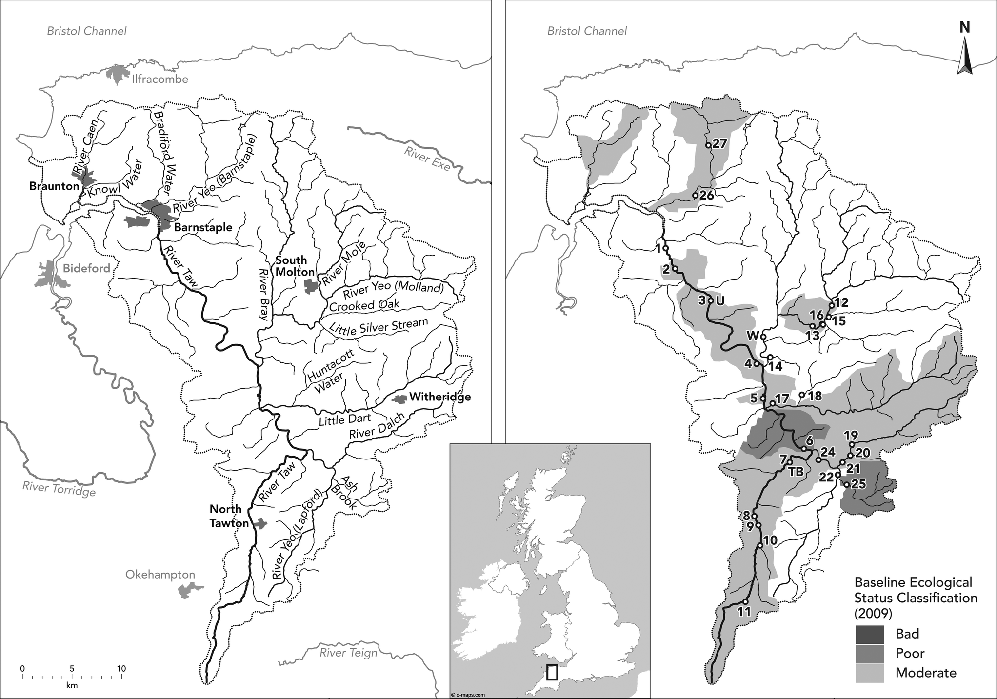 | ||
| Fig. 1 Left panel: place and river names; right panel: sampling sites (number) and gauging stations (U = Umberleigh, TB = Taw Bridge, W = Woodleigh). The baseline Ecological Status classification of 2009 (ref. 20) is also shown in the right panel. | ||
| Gauging station | NRFA station # | % of total catchment drained | Comments | Baseflow index | Daily flow data (m3 s−1) | |||
|---|---|---|---|---|---|---|---|---|
| Mean | Min | Max | Q 95 | |||||
| a Data from the National River Flow Archive (NRFA; http://www.ceh.ac.uk/data/nrfa/). | ||||||||
| Umberleigh (Taw) | 50001 | 68 | Significant modification to flows owing to public water supply abstraction. Augmentation from the Exe catchment at low flows stopped end 2002 | 0.43 | 18.0 | 0.20 | 364 | 1.23 |
| Taw Bridge (Taw) | 50007 | 6 | Water abstractions at Taw Marsh ceased ∼1999. Cheese factory at North Taw bridge abstracts from borehole but also compensates into river at low flow | 0.47 | 1.80 | 0.02 | 51.1 | 0.17 |
| Woodleigh (Mole) | 50006 | 29 | Low flows moderately affected by public water supply abstraction and augmentation from Exe-Taw transfers | 0.47 | 8.79 | 0.20 | 143 | 0.87 |
2.2 Data resource and general approach
Daily mean river flows (DMFs; calculated from 15 min interval instantaneous flow data over 24 h) were obtained from the Environment Agency (EA) gauging stations (GS) at Umberleigh and Taw Bridge on the R. Taw and Woodleigh on the R. Mole (Table 1 and Fig. 1) from 1990 onwards. Chemical determinand data from 1990, collected for statutory monitoring purposes, were also obtained from the EA WIMS for the sampling sites shown in Fig. 1 and detailed in ESI 1.† Site selection was based on EA evidence, since 2010, of failure of river waters to meet WFD Phase 1 GES for orthophosphate-P because of effluent and diffuse pollution.19 Sample record end dates occurred between 2006 and 2013, depending on site (ESI 1†). The chemical determinands considered herein are orthophosphate-P and total alkalinity. Orthophosphate-P was determined in the sample supernatant following settlement of suspended particles originally present in the collected water sample. As the supernatant may contain colloids and fine particles, as well as non-orthophosphate ‘dissolved’ P, the resulting measured P concentrations may represent orthophosphate-P plus P associated with these other components that is measurable by the analytical technique used. As a result, the orthophosphate-P as it is coded in the EA database, may be variously referred to as soluble reactive phosphorus (SRP) or reactive phosphorus (RP). In this paper the term orthophosphate-P is used by default, although the other terms are used when appropriate.For sites sampled between 1990 and 2013, water samples were collected from a maximum of 4.3% of the 8766 gauged flow days. In general, 4% of the chemical samples were collected within 7 days of each other, 15% within 14 days and 57% within 30 days. Relatively high frequency sampling (25–35 samples per year) was undertaken between 1991 and 1996 at site 2; otherwise the frequency at this site and elsewhere was 10–13 samples per year. Effluent data for STWs in the catchment were provided by the EA; the orthophosphate-P concentration was 5.3 mg P L−1 (in the centre of the range of 1–10 mg P L−1 for UK sewage effluent24) while dry weather flows for each STW were given as an annual mean. The EA also provided effluent orthophosphate-P concentration and flow data for the Taw Valley Creamery, located in the upper catchment between sites 9 and 10 (see Fig. 1), for 2006–2014. There are also many septic tanks throughout the area, which can act as either point or diffuse inputs for nutrients,14 but there were no data on either flows or nutrient concentrations available for these potential sources.
In Section 3 the data are generally reported for the R. Taw and its tributaries separately. However, at three locations (two on the R. Taw and one on the R. Mole), river flow and chemical concentration data were integrated at each of these locations individually to provide additional insights into orthophosphate-P behaviour; subsequently, the results from these three locations are discussed as a group. For the first location, the flow data from site 3 were combined with the chemical data from site 2, and for the second location chemical data for site 14 were combined with flow data for the Woodleigh GS on the R. Mole. Site 3 is ca. 4.5 km upstream of site 2, the most frequently sampled site on the R. Taw, while the Woodleigh GS is ca. 4 km upstream of site 14. For the third location, the Taw Bridge GS is co-incident with the chemical sampling at site 7 (Fig. 1). These locations are therefore referred to as site 2, site 14 and site 7. In addition to orthophosphate-P there is also a more extended treatment of the alkalinity data because of the key role of this parameter in the definition of river water quality standards for phosphorus within the WFD.
2.3 Temporal trend statistics and load estimation algorithms
Exploratory data analysis indicated that there appeared to be decreasing trends in orthophosphate-P concentrations in the time series at sites 2, 7 and 14, particularly from ca. 2003 onwards. To quantify the potential significance of these patterns at each individual site, temporal trend analyses using the Spearman's Rho, Mann–Kendall and Seasonal Kendall tests were undertaken. These tests are non-parametric, rank-based statistics designed to reveal gradual monotonic trends in time-series data25,26,28 and are appropriate for relatively coarsely-resolved data.27 The theoretical basis of the trend statistics are described in Helsel and Hirsch25 and Hipel and McLeod.28 The Seasonal Kendall test performs the Mann–Kendall test for individual seasons of the year, where season is defined by the user.26 The Mann–Kendall and Seasonal Kendall tests require the data to show constant variance through time and to not show autocorrelation.26,28 Log10 transformation of the orthophosphate-P variable satisfied the first assumption, while autocorrelation function analysis showed that the orthophosphate-P data were largely within the limits of acceptable autocorrelation. Autocorrelation is less likely to be observed in monthly resolved data of up to 10 years duration, as is the case here.26,27 Trend analyses were undertaken on both non flow-adjusted orthophosphate-P concentrations (representing the influence of both hydrological and non-hydrological factors) and flow-adjusted orthophosphate-P concentrations (representing non-hydrological factors only), following Hirsch et al.29 and Jaruskova and Liska.30 Human related activity may account for a proportion of the latter.31 For the flow-adjusted analyses, temporal trend analyses were undertaken on residuals obtained from ordinary least squares linear regression of orthophosphate-P concentration vs. flow. The data were log10 transformed prior to regression in order to ensure regression residuals were homoscedastic in each of the three cases, although Hirsch et al.29 had previously defended the use of the parametric procedure by stating that it was used only to remove variance explained by the flow variable, rather than using it for statistical modelling per se. The significance of all temporal trend results were tested at α = 0.05. The Spearman's Rho tests were undertaken using Sigmaplot® 11, while the Mann–Kendall and Seasonal Kendall tests were undertaken using an executable file developed by, and downloaded from, the US Geological Survey.26 Significance of the correlation coefficients was tested at the p < 0.05 level. Autocorrelation function analyses were undertaken using Minitab®17.The estimation of orthophosphate-P loads (mass per time) reported in the current work are based on the following algorithms:
(i) the quantitation of the low (or base) flow end member load, and its division into a groundwater and an effluent contribution follows the extended end-member mixing analysis (E-EMMA):3
| Lbaseflow = Leffluent + Lgroundwater | (1) |
| Leffluent = Σ(Cstw, Qdwf_stw) | (2) |
| Lgroundwater = Cgroundwater × Qgroundwater | (3) |
| Qgroundwater = Qriver_min − Qeffluent | (4) |
| Qeffluent = ΣQdwf_stw | (5) |
(ii) Method 5 is the favoured OSPARCOM algorithm for estimating determinand loads from periodic concentration and flow data; the load, L, is flow-weighted.2
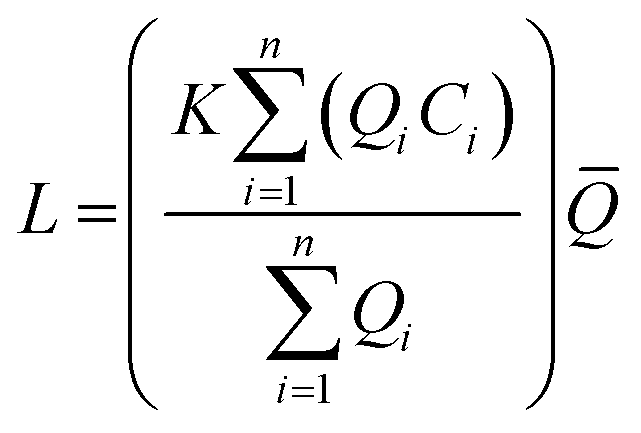 | (6) |
400 seconds per day and the load L is g d−1. ![[Q with combining macron]](https://www.rsc.org/images/entities/i_char_0051_0304.gif) is the flow-weighted term and is given by:
is the flow-weighted term and is given by: | (7) |
(iii) Method 3 defined the load as:
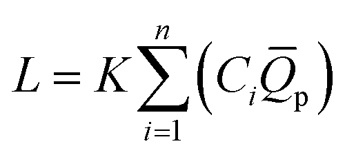 | (8) |
p is the mean flow for the period between samples.1
3. Results and discussion
3.1 Spatial and temporal variability in orthophosphate-P concentrations
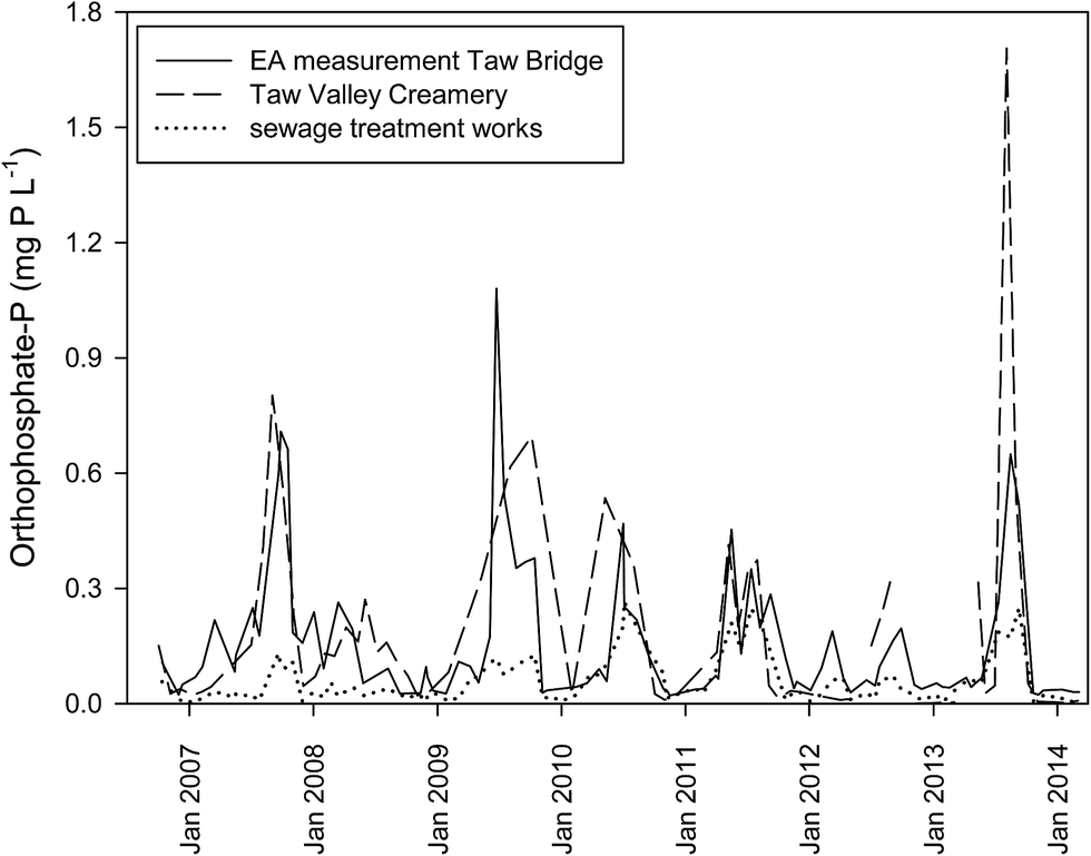 | ||
| Fig. 2 Estimated concentrations of orthophosphate-P in the river at site 7 (Taw Bridge), between October 2006 and March 2014, due to effluent inputs from the Taw Valley Creamery and the sewage treatment works located on the upper R. Taw. Also shown are the measured concentrations of orthophosphate-P from the EA WIMS dataset for the same period. For the estimated concentrations, orthophosphate-P loads (g P d−1, derived from effluent flow and concentration data) in the effluents were diluted in to the river flow (m3 d−1) gauged for that day and conservative behaviour of orthophosphate-P assumed. | ||
The annual mean concentration data for orthophosphate-P in tributary rivers are given in ESI 3.† As for the R. Taw, mean concentrations varied by an order of magnitude across the 16 sites, and variations in concentrations about the mean were large at many sites. The relatively high concentrations at site 12, on the R. Mole, were probably due to effluent discharges from the STWs located upstream at South Molton and North Molton; the former is the second largest STW in the catchment and together they have an estimated P load of 2.75 t per year, equivalent to 26% of the STW effluent P loads to rivers across the entire catchment. Downstream of site 12, orthophosphate-P concentrations decreased (sites 13 and 14), presumably due to dilution and/or loss of nutrient from solution. In addition, the tributaries draining into the Mole upstream of site 13, at sites 15 and 16, were low in orthophosphate-P. Sites 19–25 showed wide variability in mean concentrations. In this region there are a number of STWs, with an aggregate pe of over 3000 and an effluent P load of ca. 1.4 t per year, and it is likely that these inputs would have contributed to this variability. Lowest mean concentrations occurred at site 18, and at sites 26 and 27 located in the more northerly part of the catchment.
A decreasing concentration of any dissolved determinand with increasing river flow (the type 1 response10) can be largely explained by the dilution of determinand rich effluents or groundwater, or both, with determinand poor diffuse run-off from the catchment. The concentration – flow relationships for orthophosphate-P at sites 2, 7 and 14 exemplify this behaviour (ESI 4(a)†). Recasting the orthophosphate-P data as a monthly time series, shown in ESI 4(b),† similarly reveals that the highest concentrations (and largest standard deviations in concentrations) consistently occurred during the low flow, summer months. Thus, the maximum mean concentrations occurred in September at site 7 (0.94 ± 1.09 mg P L−1), in August at site 2 (0.13 ± 0.09 mg P L−1) and in July at site 14 (0.07 ± 0.05 mg P L−1).
| Site (n) | r s | Probrs | Trend | τ | ProbMK | Trend | τ | ProbSK | Trend |
|---|---|---|---|---|---|---|---|---|---|
| a n, number of data points; rs, Spearman's Rho correlation coefficient; τ, Kendall's tau correlation coefficient; Prob, p value of the significance of the trend; rs, Spearman's Rho; MK, Mann Kendall; SK, Seasonal Kendall. | |||||||||
| Orthophosphate-P (flow adjusted concentrations) | |||||||||
| 2 (126) | −0.32 | <0.001 | ↓ | −0.22 | <0.001 | ↓ | −0.35 | <0.001 | ↓ |
| 7 (129) | −0.42 | <0.001 | ↓ | −0.28 | <0.001 | ↓ | −0.32 | <0.001 | ↓ |
| 14 (83) | −0.37 | <0.001 | ↓ | −0.22 | <0.001 | ↓ | −0.30 | 0.007 | ↓ |
|
|||||||||
| Orthophosphate-P (non-flow adjusted concentrations) | |||||||||
| 2 (126) | −0.32 | <0.001 | ↓ | −0.22 | <0.001 | ↓ | −0.36 | <0.001 | ↓ |
| 7 (129) | −0.35 | <0.001 | ↓ | −0.23 | <0.001 | ↓ | −0.37 | <0.001 | ↓ |
| 14 (83) | −0.40 | <0.001 | ↓ | −0.26 | <0.001 | ↓ | −0.47 | <0.001 | ↓ |
3.2 Orthophosphate-P sources and loads
The approximately conservative behaviour of orthophosphate-P evidenced by the positive and significant coefficients of determination in the load vs. flow plots in ESI 4(c)† is perhaps counter-intuitive given the multitude of orthophosphate-P sources across the catchment, the downward temporal trend in river orthophosphate-P concentrations and known in situ orthophosphate-P reactivity in rivers.3,43 With respect to in situ reactivity, exchange of phosphorus between river bed sediments, pore waters and overlying waters in the upper Taw river and tributaries has been reported to be limited.47 In addition, within-river P cycling was unimportant relative to the source loadings of orthophosphate-P in the Dorset R. Frome, located in southern England.9 A more rigorous assessment of orthophosphate-P behaviour (i.e. conservative, non-conservative) is desirable, but this would require higher temporal sampling resolutions (daily, weekly) than the monthly sampling adopted by the EA.3
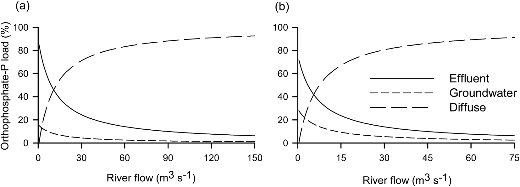 | ||
| Fig. 3 Calculated orthophosphate-P load from effluent, groundwater and diffuse run-off (%) vs. river flow (m3 s−1) at (a) site 2 on the R. Taw and (b) site 14 on the R. Mole. Note changes in scales. | ||
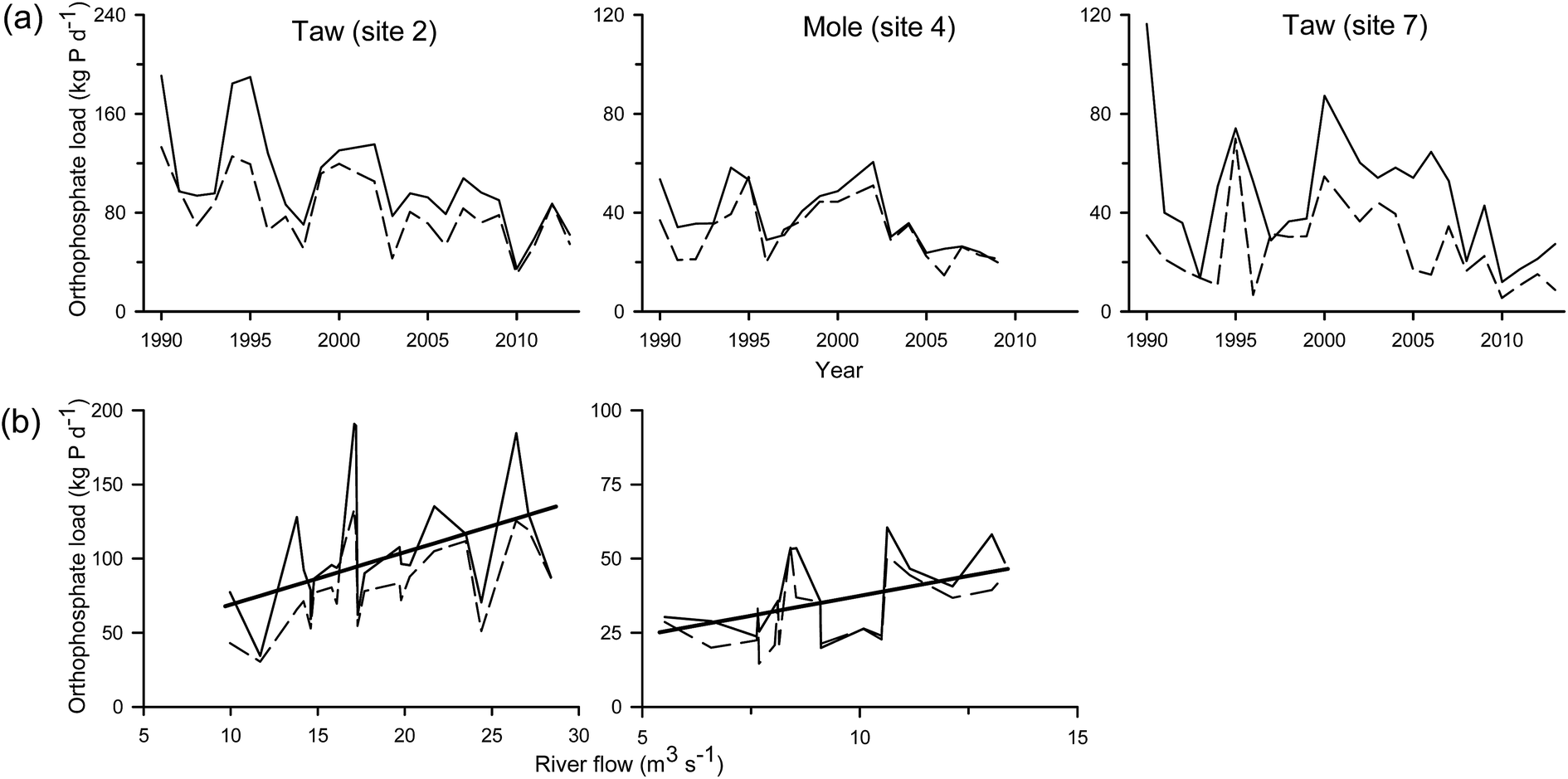 | ||
| Fig. 4 (a) Orthophosphate-P load (kg P d−1) for each year and (b) orthophosphate-P load (kg P d−1) vs. annual mean flow (m3 s−1) for each year at three sites on the R. Taw and R. Mole. Note changes in scales. Thin solid line, Method 5 mean value; dashed line, Method 5 median value; thick solid line, source apportionment model value. | ||
Bowes et al.40 calculated loads of SRP in the high BFI (0.84) R. Frome (southern England) using an algorithm assessed to be the most accurate (lowest bias) and least imprecise (Method 3, eqn (8) in Section 2.3). Based on monthly sampling, bias in annual load estimates for SRP in the R. Frome were in the range −10.6 to +12.2% (with one at +27.9%) relative to the ‘true’ load calculated from more frequently collected samples (average 3.7 samples per day for one year). Load bias may be greater in the Taw because it is a lower BFI (0.43) catchment, although because it also has a low population density, this may not necessarily be the case.41 Load estimates for total reactive phosphorus (equivalent to orthophosphate-P in the current work) based on EA monitoring data (6 samples per year; May 2011–September 2012), and using the Method 5 algorithm, gave a bias of +7.1% compared with higher resolution (hourly) data, in the low BFI (<0.50) R. Leith (northwest England) catchment.51 However, loads calculated during periods dominated by either low or high river flows showed much poorer agreement with the high sample resolution based loads, implying, inter alia, that the data record timespan used for inter-comparisons is important. Indeed, it has been shown that high resolution sampling is necessary in order to quantify short term variability in orthophosphate-P concentrations and hence loads.40 From these studies it can be concluded that the load estimates given in the current work may have a bias of up to ±20%. Maier et al.52 reported the average orthophosphate-P load at Umberleigh (site 3 in the current study) to be 37 t per year for the period 1990–2004. Extrapolation of our estimates at site 2 to an annual basis gives an average of 44 t per year over the same period and 38 t per year over the longer period of 1990–2013 examined herein, both of which are within the bias error given above.
A comparison of the loads derived from the EA WIMS monitoring data and the SAM was undertaken for sites 2 and 14. The EA derived mean and median loads for each year were plotted against the mean river flow for the year (the latter calculated from the flow weighted Method 5) and compared against the SAM calculated loads for the same flow range; the results are presented in Fig. 4(b). While the SAM calculated loads increase monotonically with flow (because only river flow changes in the model) they fall centrally within the ranges calculated using Method 5 for both sites. This agreement indicates that the inclusion of temporally variable orthophosphate-P loads into the SAM would improve the correlation between these two load estimation approaches. Diffuse load data for orthophosphate-P at site 2 (cf. ESI 4(c)†) were calculated separately for the years 1991 to 1996 when sampling frequency was relatively high (25–35 samples per year), and the modelled loads recalculated for each of those years (<8% of the data used to calculate the diffuse values were excluded as outliers). Subsequent bisquare weight linear regression of EA derived median loads against SAM calculated loads gave an R2 of 0.91 and a slope of 1.23 (n = 5, 1995 excluded). Although n is small, this good fit indicates that the approach used for estimating the diffuse concentration, exemplified in ESI 4(c),† is robust and that, on an annual basis, the estimated loads calculated by the two methods are not likely to be significantly different given that the bias (23%) is of a similar order to the bias in orthophosphate-P load estimations reported previously.40,51 While this agreement is encouraging, the advantage of the SAM approach, relative to the Method 5 load estimation, is the ability to separately identify the diffuse and point load components.
The load estimation approaches described in Sections 3.2.1 to 3.2.4 can be summarised and linked in the following way. Base flow orthophosphate-P loads from groundwater and effluents revealed that at lowest river flows, effluent contributed 72–96% of the load at the three sites examined. Data from the base flow loads and integrated catchment inputs of orthophosphate-P were combined to give a source apportionment model which showed that effluent orthophosphate-P contributed at least half of the orthophosphate-P load for 27–48% of the time. This outcome is consistent with recent reports of the importance of effluent orthophosphate-P at low river flows in other English catchments (e.g.10). Orthophosphate-P loads were also calculated from EA WIMS data using the OSPARCOM Method 5 and compared with the loads derived from the SAM. The proximity between the load estimates derived from the two approaches appeared to be of the same magnitude as the bias in orthophosphate-P loads reported for other lower BFI English rivers.51 It is anticipated that inclusion of more highly temporally resolved data would improve the agreement between these two load estimation approaches, although there appears to be a dearth of studies on the relationship between sampling frequency and orthophosphate-P load uncertainties in effluent impacted low BFI UK rivers.
3.3 Water quality
The RP standard, which is a calculated annual mean concentration, is defined by eqn (9):
| RP standard (μg P L−1) = 10^((1.0497log10(EQR) + 1.066) × (log10(reference condition RP) − log10(3500)) + log10(3500)) | (9) |
The RP standard is the concentration estimated for the lower class boundary of the High, Good, Moderate and Poor Ecological Status. The Ecological Status depends on the value of EQR used, where EQR is the site independent ecological quality ratio at the class boundary.15,16 The ‘reference condition RP’ is the RP concentration expected at near natural conditions, subject to local geology and geography. It can be estimated as:
| Reference condition RP = 10^(0.454(log10alkalinity) − 0.0018(altitude) + 0.476) | (10) |
Alkalinity is the mean annual total alkalinity (mg CaCO3 L−1) of the water (a proxy for geology and location) at a given site and the altitude is height (in m, AOD). The annual spatial and temporal variability in the concentrations (mean ± one standard deviation) of alkalinity for the R. Taw and the tributary rivers are summarised in ESI 5 and 6,† respectively. There were no clear temporal trends in mean annual concentrations of alkalinity across the catchment, but there were marked spatial differences. On the R. Taw there was a notable increase in alkalinity concentrations in the upper catchment between site 10 and the downstream site 9. This pattern, and indeed the trends in the remainder of the R. Taw, mirrored those of orthophosphate – P. In the tributary rivers, the highest mean concentrations occurred at sites 22–25 and to a lesser extent at sites 19–21. It is also noteworthy that the sites with the highest mean concentrations also had the largest standard deviations about the mean concentration.
Eqn (9) and (10) have been used to retrospectively examine the compliance of the R. Taw and its tributaries with the Phase 2 RP standards and the results are reported in Fig. 5 and ESI 7.† For the R. Taw itself, most sites (4, 5, 6, 7, 8, 9) would be classified as ‘Poor’, while sites 2, 3 and 10 would be classified as ‘Moderate’ and site 10 occasionally as ‘Good’. The ratio of the measured RP to reference condition RP can be calculated for each year for each site and is a quantitation of the human impact on ambient phosphate-P concentrations.15 The ratio values reflect the range found for Ecological Status, with measured orthophosphate-P concentrations at ‘Poor’ sites factors of 10 or more above the reference condition, implying marked anthropogenic nutrient pressures at these locations. For the tributary rivers the Ecological Status would be better, with a number of sites achieving ‘Good’ in some years (sites 14, 15, 16, 18, 26, 27). Nevertheless, sites 19–25 appear particularly impacted, with a ‘Poor’ status dominant and ratios generally >10.
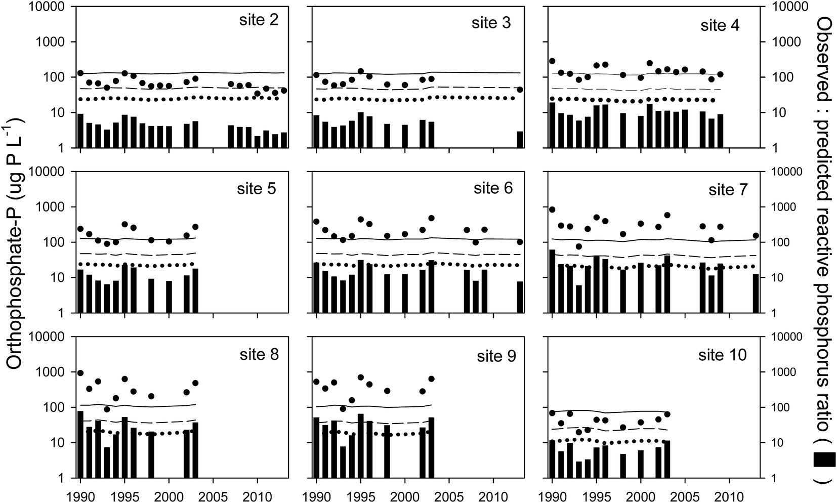 | ||
| Fig. 5 Water framework directive (Phase 2) reactive phosphorus standards for the R. Taw. Solid line, poor/moderate boundary; dashed line, moderate/good boundary; dotted line, good/high boundary (all μg P L−1). Observed mean annual concentrations of orthophosphate-P (●; μg P L−1). Vertical bars show the ratio of the observed and predicted reactive phosphorus concentrations. | ||
While there are uncertainties in correlating RP standards with actual biological impacts,16 it is likely that concentrations of orthophosphate-P in the Taw catchment rivers, particularly during summer, were generally above concentrations considered detrimental to periphyton and benthic diatom communities. Fig. 6 shows orthophosphate-P concentrations for the summer growing season (April to September) for two sites on the Taw with the lowest orthophosphate-P values; site 10 in the upper catchment and site 2 at the catchment outlet (for the tributaries, only sites 18, 26 and 27 exhibited similarly low concentrations). Also shown on Fig. 6 are reported Phosphorus Limiting Concentrations (PLC) for some UK and US rivers below which periphyton biomass accrual rates were observed to decline (summarised in54). It can be seen that most orthophosphate-P concentrations were in the range of these PLC values, particularly in the later part of the time series. Targeted experiments on the Taw itself would be required to see if a decrease in algal biomass had indeed occurred. As these sites probably represent the best case scenarios it is likely that the remaining sites in the Taw catchment would require more comprehensive mitigation measures in order to achieve GES with respect to orthophosphate-P.
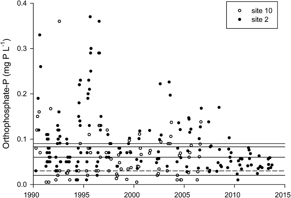 | ||
| Fig. 6 Orthophosphate-P (mg P L−1) concentrations at site 10 and site 2 on the R. Taw during the April to September algal growing period. The horizontal lines show the Phosphorus Limiting Concentrations (PLC), reported for different UK and US rivers, below which P was the limiting nutrient and periphyton growth declined. The dashed line shows the concentration below which a positive change in diatom community composition was observed. See Bowes et al.54 for a more detailed account of the PLC data. | ||
While the Phase 2 RP standards are framed as annual mean concentrations, many studies have highlighted the importance of orthophosphate-P to periphyton and benthic diatom growth during the low flow, summer months.13,55 From eqn (1) it has been established that low river flows can have contributions from both groundwater and effluents from sewage treatment and industrial sources, and the relative importance of these sources to orthophosphate-P at three sites in the Taw was estimated from eqn (1)–(5). This approach can be extended to alkalinity because sewage (and some industrial) effluent contains alkalinity (principally carbonate/bicarbonate, but also borate and organic acids, and orthophosphate-P itself18), and so, at low flows, riverine alkalinity will have both a groundwater and an effluent component. Summary plots of alkalinity concentration vs. river flow and monthly variations in alkalinity concentrations for the sites 2, 7 and 14 in the Taw catchment (Fig. 7(a) and (b), respectively) are consistent with this contention, with the highest concentrations occurring at low flows and during the summer months. Notably, these trends mirror those for orthophosphate-P shown in ESI 4(a) and (b).†
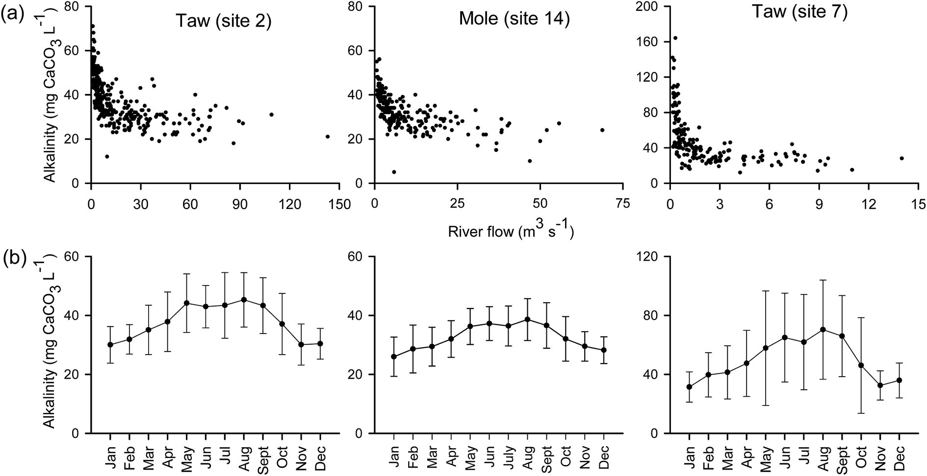 | ||
| Fig. 7 (a) Concentrations of total alkalinity (mg CaCO3 L−1) vs. river flow (m3 s−1) at gauged sites on the R. Taw and R. Mole. (b) Monthly mean (±1 standard deviation) concentrations of total alkalinity (mg CaCO3 L−1) for the same sites. Note changes in concentration scales. | ||
The presence of effluent alkalinity implies that the calculated “reference condition” and “Ecological Status boundary” RP concentrations may be incorrect, the size of the discrepancy being dependent on the proportion of effluent alkalinity. In addition, the calculated RP concentration at a given boundary may be higher in effluent influenced rivers, relative to groundwater dominated rivers, thereby giving a misleading impression of the ecological status of the water body. Separation of the measured alkalinity at low river flows into these two components, using eqn (1)–(5), has been done for sites 2, 7 and 14. Fig. 8 summarises the calculations, including the data used and underlying assumption made. Thus, it has been estimated that ca. 43, 76 and 26%, respectively, of the measured river alkalinity at these sites was from effluent. Reference condition RP and High/Good RP boundaries were then calculated with and without this effluent component for the ecologically important summer period of April to September (Fig. 9). The measured: predicted RP ratio increased by 29%, 89% and 15% at sites 2, 7 and 14, respectively, while the reference condition RP concentrations decreased by the same margins. The associated RP concentrations delineating the High/Good boundary fell by 26%, 78% and 13%, respectively, at these sites.
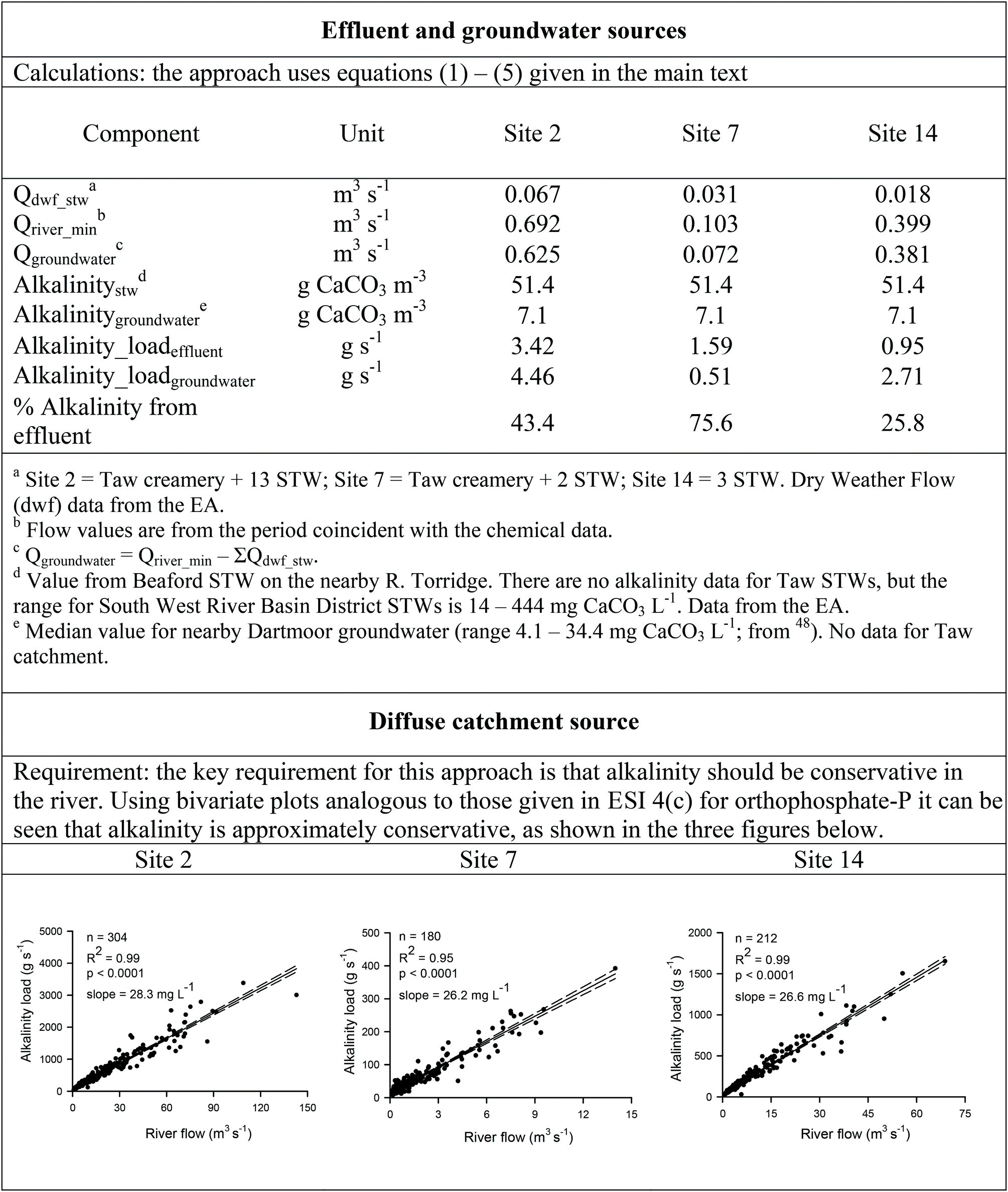 | ||
| Fig. 8 Estimation of the contribution of effluents, groundwater and diffuse catchment sources to river alkalinity loads at sites 2, 7 and 14 in the Taw catchment. | ||
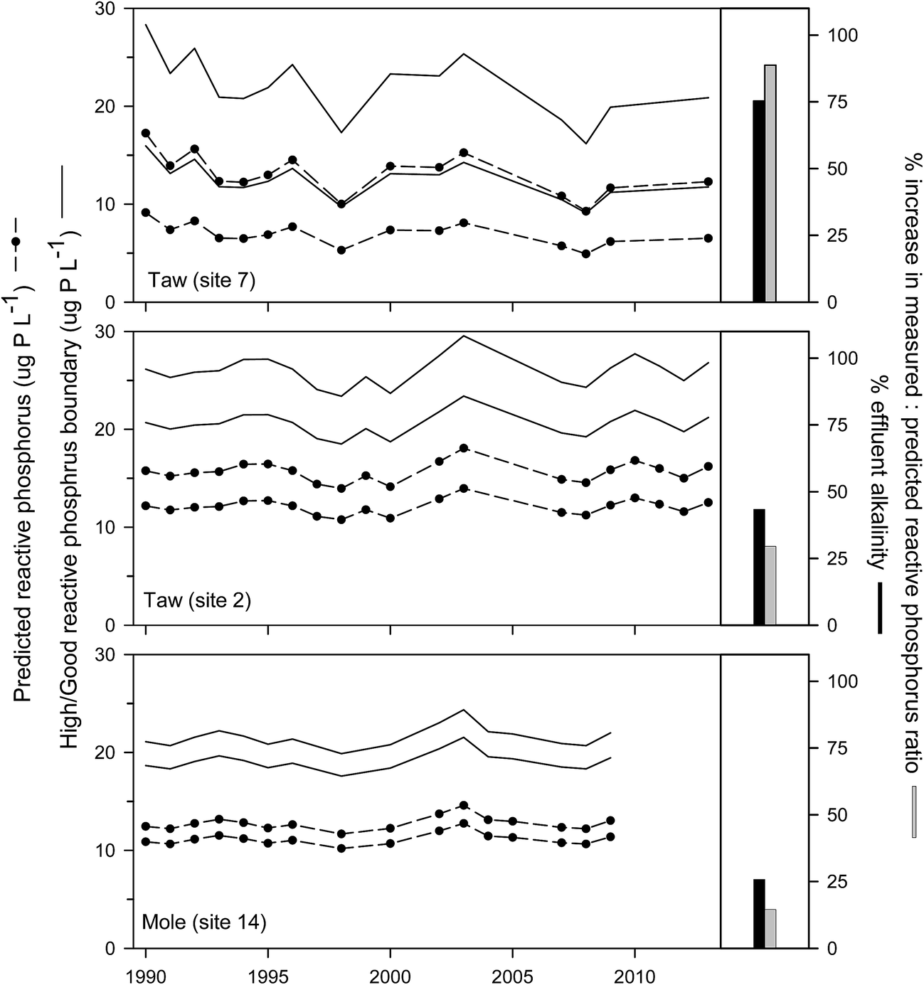 | ||
| Fig. 9 Right panel: bar chart shows the % contribution of effluent to the measured river alkalinity at each site and the % increase in the measured: predicted reactive phosphorus (RP) ratio after subtraction of the effluent component of the measured alkalinity. Left panel: Solid lines show the decrease in the High/Good boundary concentration of RP, while the circle/dashed lines show the decrease in the predicted RP concentration, after subtraction of the effluent component of the measured alkalinity. Analysis for the summer period (April–September) only. | ||
The significance of these results with respect to nutrient reduction strategies, at this time, should be placed in the context that the Phase 2 standards are for annual mean concentrations of both alkalinity and RP. For example, using the data in Fig. 8, it is possible to apportion river loads of alkalinity from the different sources (effluent, groundwater, diffuse) against changes in river flow (cf. orthophosphate-P in Fig. 3). The results, shown in Fig. 10, suggest that both effluent and groundwater alkalinity are important at low flows, consistent with the calculations above. Thus, for flows ≤Q95 value, effluents may account for 25–50% of the alkalinity load for the sites representing the outlets of the Taw and Mole catchments. Nevertheless, because of the paucity of data on flows and concentrations used in this analysis, as noted in footnotes d and e to Fig. 8, these results probably provide only a first order assessment of the importance of alkalinity sources under contrasting river flows, and in particular at low flows. Additional work using more constrained datasets would serve to reduce the uncertainties and arguably contribute to a more refined set of phosphorus standards for inclusion in a Phase 3 cycle of standards revisions under the WFD.
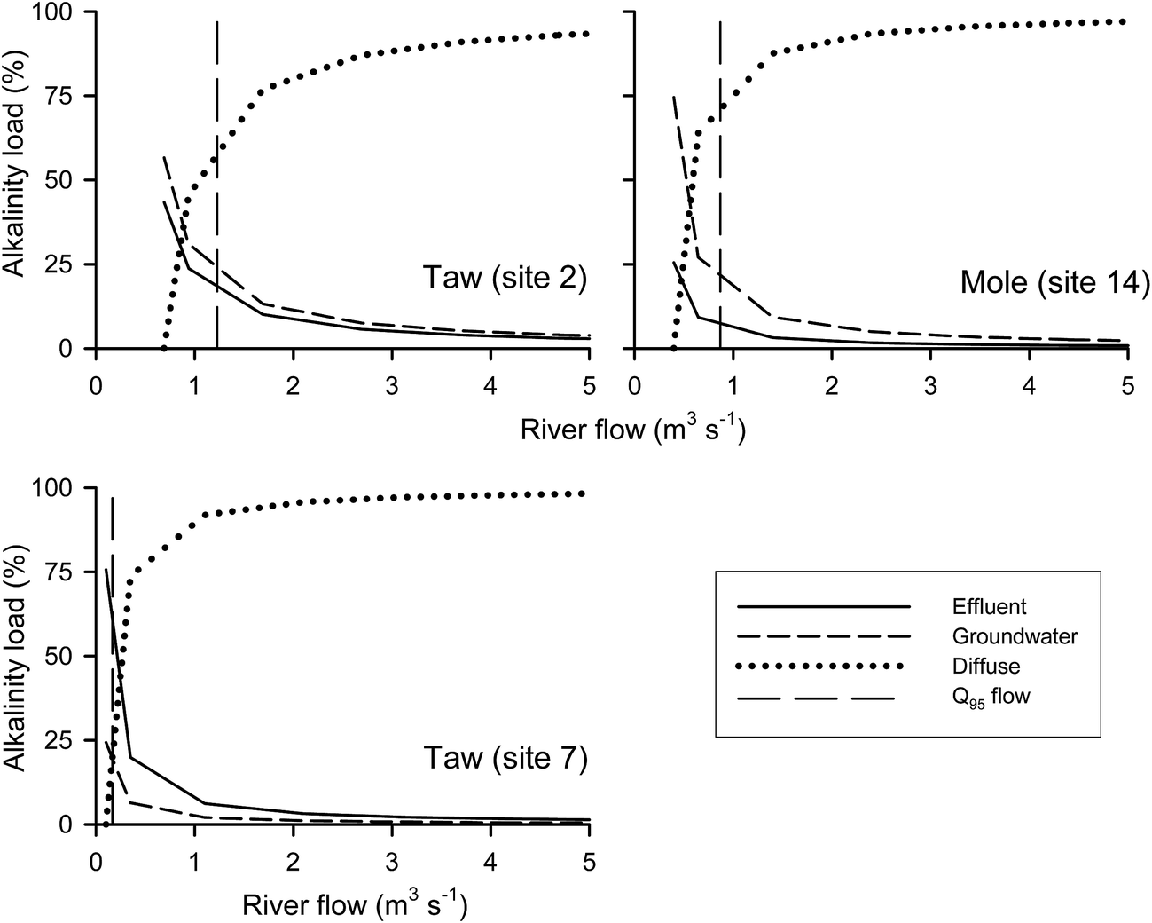 | ||
| Fig. 10 Estimated contribution to river alkalinity load from effluent, groundwater and diffuse run-off (%) vs. river flow (m3 s−1) at three sites on the R. Taw and R. Mole. The Q95 flow values are from Table 1. | ||
4. Summary and conclusions
The results from a source apportionment model incorporating effluent, groundwater and diffuse loads of orthophosphate-P suggested that effluent discharged to the rivers in the Taw catchment contributes approximately half of the orthophosphate-P load for up to half of the time across the catchment. However, during the more biologically important summer months, significant contributions of sewage (across the catchment) and industrial effluent (upper R. Taw) to orthophosphate-P concentrations (up to 96%) occur. These sources probably contribute to the generally Poor to Moderate Ecological Status of the rivers with respect to the recently introduced WFD Phase 2 standards for phosphorus. Since the early-2000s, orthophosphate-P concentrations appear to have decreased, for reasons not identified herein, with no clear improvement in overall ecological status. To compound the failure to meet Good Ecological Status at most sites sampled, it has been demonstrated that sewage and industrial effluent sources of alkalinity to the river can give erroneous boundary concentrations of reactive phosphorus for WFD Ecological Status classification, and in effect relax the standards.While the sampling resolution of the EA chemical monitoring programme, particularly in the temporal dimension, frequently attracts criticism, the resulting data archived in the WIMS database, at a national level, are an important resource that can be used, with due diligence, to assess and address problems in catchment management. In the current work, the high orthophosphate-P concentrations observed in the upper R. Taw were largely due to industrial effluent from a single source, coupled with more minor contributions from STWs, while at the catchment scale, the enhanced summer concentrations of orthophosphate-P were due to STW effluents. These point sources appeared to be the major cause of failure to meet GES under the WFD. Reductions in orthophosphate-P loads from effluents could be achieved via chemical precipitation using metal chloride, although the costs may be prohibitive. In the future, the development of an EU-wide Phosphorus Circular Economy to severely restrict P losses to the environment, as advocated by the European Sustainable Phosphorus Platform, may drive through these mitigation measures. The estimated diffuse catchment runoff concentrations of ca. 0.03 mg L−1 orthophosphate-P, if maintained at this level, would alone cause many sites to fail GES under the WFD Phase 2 standards. There is no requirement under the current UWWTD to further reduce orthophosphate-P loads from STW and industrial effluents in the Taw catchment and so unless driven by the WFD, it is unlikely that most rivers in the Taw catchment will achieve GES in the foreseeable future.
For catchments like the Taw, with an extensive sampling history, both spatially and temporally, it is arguable that the regulatory agencies should investigate alternative sampling strategies that would provide more useful data for management/policy purposes while at the same time be resource neutral and still fulfil statutory monitoring obligations. For example, the number of sites regularly sampled could be reduced to those with known issues plus sites located at the catchment outlets, including sub-catchments, where sampling frequency could be markedly increased. The latter approach would provide improved estimates of catchment nutrient loads, as defined in this study, and at the same time allow more accurate and precise land to sea flux estimates of contaminants required by OSPARCOM. Reduced routine sample throughput could also allow a more comprehensive set of analyses per sample, of particular importance for phosphorus because it occurs in a variety of inorganic and organic fractions with varying bioavailabilities. With anticipated changes in rainfall patterns, in particular increases in the frequency of short sharp summer rain events, it may be prudent to undertake “smart sampling” during these events (using a combination of meteorological predictions for summer rainfall with in situ measurement technologies) in order to improve understanding of nutrient transfers during intermittent wetting up of catchments. The aspiration for in situ measurements, inter alia, is that they should measure the bioavailable P as defined by the Environmental Quality Standard that is current at the time; while in situ measurements of (dissolved) reactive phosphorus in rivers are now being more frequently reported, it is evident that the instrumentation requires further development, particularly in relation to the more specific definition of filtered reactive phosphorus given in the WFD Phase 2 standard.
The contribution of sewage effluent to riverine concentrations of alkalinity appeared significant in the Taw, particularly during the key summer months. Given the extent of urbanisation within Europe it would appear prudent to extend this analysis in order to properly assess the contributions of effluent alkalinity to river alkalinity across the EU. This would no doubt provide a more nuanced derivation of river phosphorus standards in a future WFD river basin management cycle.
Abbreviations and definitions
| Term | Abbreviation | Definition |
|---|---|---|
| Above ordnance datum | AOD | Height (in m) above mean sea level at Newlyn |
| Base flow index | BFI | Generally, the contribution of groundwater flow to river runoff as a ratio; the higher the contribution the higher the BFI value |
| Daily mean flow | DMF | Mean river flow (in m3 s−1) in a water-day (09.00 to 09.00 GMT). Typically, flows are calculated on the basis of measurements at 15 minute intervals |
| Extended end-member mixing analysis | E-EMMA | The use of water quality monitoring data to generate plots of flux of a chemical analyte against flow which may be used to infer and quantify analyte retention and/or release within a river catchment |
| Ecological quality ratio | EQR | This determines the P concentration at the lower class boundary for each ecological class under the WFD (i.e. high, good, moderate, poor) |
| Good ecological status | GES | The aspiration of the WFD (see below) that all surface waters reach this status by 2015 |
| Load | Mass per time | |
| Method 3 | Load estimation algorithm from Littlewood.1 Defined in Section 2.3 | |
| Method 5 | Load estimation algorithm from Littlewood et al.2 Defined in Section 2.3 | |
| Orthophosphate-P | Generic term used in the current study to describe P concentrations measured for regulatory purposes | |
| Phosphorus limiting concentrations | PLC | River phosphorus concentration below which algal growth is nutrient limited |
| Population equivalent | pe | |
| Q 95 flow | Flow (in m3 s−1) which was equalled or exceeded for 95% of the flow record | |
| Reactive phosphorus | RP | Fraction of phosphorus passing through a 0.45 μm filter membrane and measured by the phosphomolybdenum blue colorimetric method |
| Sewage treatment works | STW | |
| Soluble reactive phosphorus | SRP | Fraction of phosphorus measured by the phosphomolybdenum blue colorimetric method after settling of suspended particles from the river water sample |
| Water framework directive | WFD | |
| Water information management system | WIMS | A chemical dataset collected and compiled by the Environment Agency of England |
Acknowledgements
We would like to thank the Environment Agency of England for providing the chemical monitoring data, and the National River Flow Archive for access to river flow data. Dr Alba Navarro Rodrigeuz undertook the alkalinity calculations, with funding from the Seale-Hayne Educational Trust of Plymouth University. We thank the two reviewers for their comments, which helped to sharpen the focus of the paper.References
- I. G. Littlewood, Estimating contaminant loads in rivers: a review, Institute of Hydrology, Report No. 117, 1992 Search PubMed.
- I. G. Littlewood, C. D. Watts and J. M. Custance, Sci. Total Environ., 1998, 210–211, 21–40 CrossRef.
- H. P. Jarvie, C. Neal, P. J. A. Withers, D. B. Baker, R. P. Richards and A. N. Sharpley, J. Environ. Qual., 2011, 40, 492–504 CrossRef CAS PubMed.
- ETC/ICM (European Topic Centre), Ecological and chemical status and pressures in European waters, Thematic assessment for EEA Water 2012 Report, 2012 Search PubMed.
- European Environment Agency, Nutrients in Freshwater (CSI 020/WAT 003), 2015 Search PubMed.
- C. Miller, A. Magdalina, R. I. Willows, A. W. Bowman, E. M. Scott, D. Lee, C. Burgess, L. Pope, F. Pannullo and R. Haggarty, Sci. Total Environ., 2014, 466–467, 914–923 CrossRef CAS PubMed.
- J. H. Kinniburgh and M. Barnett, Water Environ. J., 2010, 24, 107–115 CrossRef CAS.
- C. Neal, M. Bowes, H. P. Jarvie, P. Scholefield, G. Leeks, M. Neal, P. Rowland, H. Wickham, S. Harman, L. Armstrong, D. Sleep, A. Lawlor and C. E. Davies, Hydrol. Processes, 2012, 26, 949–960 CrossRef CAS.
- M. J. Bowes, J. T. Smith, H. P. Jarvie, C. Neal and R. Barden, Sci. Total Environ., 2009, 407, 1954–1966 CrossRef CAS PubMed.
- M. J. Bowes, J. T. Smith, C. Neal, D. V. Leach, P. M. Scarlett and H. D. Wickham, Sci. Total Environ., 2011, 409, 3418–3430 CrossRef CAS PubMed.
- A. D. Tappin, U. Mankasingh, I. D. McKelvie and P. J. Worsfold, Environ. Monit. Assess., 2013, 185, 4791–4818 CrossRef CAS PubMed.
- H. P. Jarvie, P. M. Haygarth, C. Neal, P. Butler, B. Smith, P. S. Naden, A. Joynes, M. Neal, H. Wickham, L. Armstrong, S. Harman and E. J. Palmer-Felgate, J. Hydrol., 2008, 350, 215–231 CrossRef CAS.
- H. P. Jarvie, C. Neal and P. J. A. Withers, Sci. Total Environ., 2006, 360, 246–253 CrossRef CAS PubMed.
- P. J. A. Withers, H. P. Jarvie and C. Stoate, Environ. Int., 2011, 37, 644–653 CrossRef CAS PubMed.
- UKTAG (UK Technical Advisory Group on the Water Framework Directive), A revised approach to setting Water Framework Directive phosphorus standards, 2012 Search PubMed.
- UKTAG (UK Technical Advisory Group), Phosphorus standards for rivers, Updated recommendations, August 2013, 2013 Search PubMed.
- C. Neal, H. P. Jarvie, M. Neal, A. J. Love, L. Hill and H. Wickham, J. Hydrol., 2005, 304, 103–117 CrossRef CAS.
- C. W. Hunt, J. E. Salisbury and D. Vandemark, Biogeosciences, 2011, 8, 3069–3076 CrossRef CAS.
- Environment Agency, Water Framework Directive (WFD) – Ecological status, evidence pack for the River Taw, 2013 Search PubMed.
- Environment Agency, River basin management plan, South West River Basin District, 2009 Search PubMed.
- Environment Agency, Taw and north Devon streams catchment abstraction management strategy, 2006 Search PubMed.
- E. Lord, et al., Investigating the effectiveness of NVZ Action Programme measures: Development of a strategy for England, ADAS, Wolverhampton, 2007 Search PubMed.
- J. R. E. Newman, Eutrophication in rivers: an ecological perspective, Centre of Ecology and Hydrology, 2006 Search PubMed.
- A. C. Edwards and P. J. A. Withers, J. Hydrol., 2008, 350, 144–153 CrossRef CAS.
- D. R. Helsel and R. M. Hirsch, Techniques of water-resources investigations of the United States Geological Survey, Book 4, Hydrologic analysis and interpretation, Chapter A3 Statistical methods in water resources, 2002 Search PubMed.
- D. R. Helsel, D. K. Mueller and J. R. Slack, Computer program for the Kendall family of trend tests, U.S. Geological Survey Scientific Investigations Report 2005–5275, 2006 Search PubMed.
- C. E. M. Lloyd, J. E. Freer, A. L. Collins, P. J. Johnes and J. I. Jones, J. Hydrol., 2014, 514, 297–312 CrossRef CAS.
- K. W. Hipel and A. I. McLeod, Time series modelling of water resources and environmental systems, Elsevier, 1994 Search PubMed.
- R. M. Hirsch, J. R. Slack and R. A. Smith, Water Resour. Res., 1982, 18, 107–121 CrossRef.
- D. Jaruskova and I. Liska, J. Environ. Monit., 2011, 13, 1435–1445 RSC.
- J. W. Mayo and K. J. Leib, Flow-adjusted trends in dissolved selenium load and concentration in the Gunnison and Colorado Rivers near Grand Junction, Colorado, water years 1986–2008. U.S. Geological Survey Scientific Investigations Report 2012–5088, 2012 Search PubMed.
- C. Neal and A. J. Robson, Sci. Total Environ., 2000, 251–252, 585–665 CrossRef PubMed.
- J. J. Rothwell, N. B. Dise, K. G. Taylor, T. E. H. Allott, P. Scholefield, H. Davies and C. Neal, Sci. Total Environ., 2010, 408, 841–855 CrossRef CAS PubMed.
- J. Hannaford and G. Buys, J. Hydrol., 2012, 475, 158–174 CrossRef.
- M. J. Bowes, C. Neal, H. P. Jarvie, J. T. Smith and H. N. Davies, Sci. Total Environ., 2010, 408, 4239–4250 CrossRef CAS PubMed.
- C. Neal, H. P. Jarvie, R. Williams, A. Love, M. Neal and H. E. A. Wickham, Sci. Total Environ., 2010, 408, 1315–1330 CrossRef CAS PubMed.
- S. Comber, M. Gardner, K. Georges, D. Blackwood and D. Gilmour, Environ. Technol., 2013, 34, 1349–1358 CrossRef CAS PubMed.
- DEFRA, The British survey of fertiliser practice, Fertiliser use on farm crops for crop year 2002, Crown Copyright, 2003 Search PubMed.
- DEFRA, The British survey of fertiliser practice, Fertiliser use on farm crops for crop year 2013, 2014 Search PubMed.
- M. J. Bowes, J. T. Smith and C. Neal, J. Hydrol., 2009, 378, 82–96 CrossRef CAS.
- P. Johnes, J. Hydrol., 2007, 332, 241–258 CrossRef.
- P. Jordan, A. Arnscheidt, H. McGrogan and S. McCormick, Hydrology and Earth Systems Science, 2007, 11, 372–381 CrossRef CAS.
- C. Neal, H. P. Jarvie, P. J. A. Withers, B. A. Whitton and M. Neal, Sci. Total Environ., 2010, 408, 1315–1330 CrossRef CAS PubMed.
- D. M. Cooper, W. A. House, L. May and B. Gannon, Sci. Total Environ., 2002, 282–283, 233–251 CrossRef CAS PubMed.
- J. N. Miller and J. C. Miller, Statistics and chemometrics for analytical chemistry, Pearson Education Limited, 6th edn, 2010 Search PubMed.
- F. L. Wood, A. L. Heathwaite and P. M. Haygarth, J. Hydrol., 2005, 304, 118–138 CrossRef CAS.
- E. E. Burns, S. Comber, W. Blake, R. Goddard and L. Couldrick, Environ. Sci. Pollut. Res., 2015, 22, 9816–9828 CrossRef CAS PubMed.
- P. Shand, W. M. Edmunds, A. R. Lawrence, P. L. Smedley and S. Burke, The natural (baseline) quality of groundwater in England and Wales, British Geological Survey Research Report No. RR/07/06, 2007 Search PubMed.
- P. L. Smedley and D. Allen, Baseline Report Series 16: the Granites of South-west England, British Geoligical Survey Commissioned Report No. CR/04/255, 2004 Search PubMed.
- I. G. Littlewood and T. J. Marsh, J. Hydrol., 2005, 304, 221–237 CrossRef CAS.
- M. Z. Bieroza, A. L. Heathwaite, N. J. Mullinger and P. O. Keenan, Environ. Sci.: Processes Impacts, 2014, 16, 1676–1691 CAS.
- G. Maier, G. A. Glegg, A. D. Tappin and P. J. Worsfold, Mar. Pollut. Bull., 2009, 58, 1007–1015 CrossRef CAS PubMed.
- DEFRA, Water Framework Directive implementation in England and Wales: new and updated standards to protect the water environment, May 2014, 2014 Search PubMed.
- M. J. Bowes, N. L. Ings, S. J. McCall, A. Warwick, C. Barrett, H. D. Wickham, S. A. Harman, L. K. Armstrong, P. M. Scarlett, C. Roberts, K. Lehmann and A. C. Singer, Sci. Total Environ., 2012, 434, 201–212 CrossRef CAS PubMed.
- C. Mainstone, An evidence base for setting nutrient targets to protect river habitat, Natural England Research Report NERR034, 2010 Search PubMed.
Footnote |
| † Electronic supplementary information (ESI) available. See DOI: 10.1039/c6em00213g |
| This journal is © The Royal Society of Chemistry 2016 |