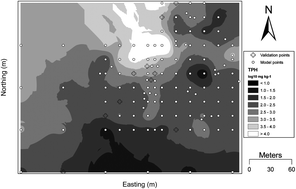
Visible near-infrared (VisNIR) diffuse reflectance spectroscopy (DRS) is a rapid, non-destructive method for sensing the presence and amount of total petroleum hydrocarbon (TPH) contamination in soil. This study demonstrates the feasibility of VisNIR DRS to be used in the field to proximally sense and then map the areal extent of TPH contamination in soil. More specifically, we evaluated whether a combination of two methods, penalized spline regression and geostatistics could provide an efficient approach to assess spatial variability of soil TPH using VisNIR DRS data from soils collected from an 80 ha crude oil spill in central Louisiana, USA. Initially, a penalized spline model was calibrated to predict TPH contamination in soil by combining lab TPH values of 46 contaminated and uncontaminated soil samples and the first-derivative of VisNIR reflectance spectra of these samples. The r2, RMSE, and bias of the calibrated penalized spline model were 0.81, 0.289 log10 mg kg−1, and 0.010 log10 mg kg−1, respectively. Subsequently, the penalized spline model was used to predict soil TPH content for 128 soil samples collected over the 80 ha study site. When assessed with a randomly chosen validation subset (n = 10) from the 128 samples, the penalized spline model performed satisfactorily (r2 = 0.70; residual prediction deviation = 2.0). The same validation subset was used to assess point kriging interpolation after the remaining 118 predictions were used to produce an experimental semivariogram and map. The experimental semivariogram was fitted with an exponential model which revealed strong spatial dependence among soil TPH [r2 = 0.76, nugget = 0.001 (log10 mg kg−1)2, and sill 1.044 (log10 mg kg−1)2]. Kriging interpolation adequately interpolated TPH with r2 and RMSE values of 0.88 and 0.312 log10 mg kg−1, respectively. Furthermore, in the kriged map, TPH distribution matched with the expected TPH variability of the study site. Since the combined use of VisNIR prediction and geostatistics was promising to identify the spatial patterns of TPH contamination in soils, future research is warranted to evaluate the approach for mapping spatial variability of petroleum contaminated soils.

 Please wait while we load your content...