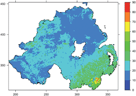
Regulatory authorities need ways to estimate natural terrestrial gamma radiation dose rates (nGy h−1) across the landscape accurately, to assess its potential deleterious health effects. The primary method for estimating outdoor dose rate is to use an in situ detector supported 1 m above the ground, but such measurements are costly and cannot capture the landscape-scale variation in dose rates which are associated with changes in soil and parent material mineralogy. We investigate the potential for improving estimates of terrestrial gamma dose rates across Northern Ireland (13 542 km2) using measurements from 168 sites and two sources of ancillary data: (i) a map based on a simplified classification of soil parent material, and (ii) dose estimates from a national-scale, airborne radiometric survey. We used the linear mixed modelling framework in which the two ancillary variables were included in separate models as fixed effects, plus a correlation structure which captures the spatially correlated variance component. We used a cross-validation procedure to determine the magnitude of the prediction errors for the different models. We removed a random subset of 10 terrestrial measurements and formed the model from the remainder (n = 158), and then used the model to predict values at the other 10 sites. We repeated this procedure 50 times. The measurements of terrestrial dose vary between 1 and 103 (nGy h−1). The median absolute model prediction errors (nGy h−1) for the three models declined in the following order: no ancillary data (10.8) > simple geological classification (8.3) > airborne radiometric dose (5.4) as a single fixed effect. Estimates of airborne radiometric gamma dose rate can significantly improve the spatial prediction of terrestrial dose rate.
You have access to this article
 Please wait while we load your content...
Something went wrong. Try again?
Please wait while we load your content...
Something went wrong. Try again?
