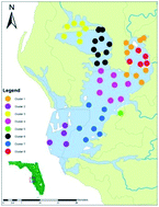
This study presents an integrated k-means clustering and gravity model (IKCGM) for investigating the spatiotemporal patterns of nutrient and associated dissolved oxygen levels in Tampa Bay, Florida. By using a k-means clustering analysis to first partition the nutrient data into a user-specified number of subsets, it is possible to discover the spatiotemporal patterns of nutrient distribution in the bay and capture the inherent linkages of hydrodynamic and biogeochemical features. Such patterns may then be combined with a gravity model to link the nutrient source contribution from each coastal watershed to the generated clusters in the bay to aid in the source proportion analysis for environmental management. The clustering analysis was carried out based on 1 year (2008) water quality data composed of 55 sample stations throughout Tampa Bay collected by the Environmental Protection Commission of Hillsborough County. In addition, hydrological and river water quality data of the same year were acquired from the United States Geological Survey's National Water Information System to support the gravity modeling analysis. The results show that the k-means model with 8 clusters is the optimal choice, in which cluster 2 at Lower Tampa Bay had the minimum values of total nitrogen (TN) concentrations, chlorophyll a (Chl-a) concentrations, and ocean color values in every season as well as the minimum concentration of total phosphorus (TP) in three consecutive seasons in 2008. The datasets indicate that Lower Tampa Bay is an area with limited nutrient input throughout the year. Cluster 5, located in Middle Tampa Bay, displayed elevated TN concentrations, ocean color values, and Chl-a concentrations, suggesting that high values of colored dissolved organic matter are linked with some nutrient sources. The data presented by the gravity modeling analysis indicate that the Alafia River Basin is the major contributor of nutrients in terms of both TP and TN values in all seasons. With this new integration, improvements for environmental monitoring and assessment were achieved to advance our understanding of sea–land interactions and nutrient cycling in a critical coastal bay, the Gulf of Mexico.
You have access to this article
 Please wait while we load your content...
Something went wrong. Try again?
Please wait while we load your content...
Something went wrong. Try again?
