
Evaluation of the differences between the SRTM and satellite radar altimetry height measurements and the approach taken for the ACE2 GDEM in areas of large disagreement
Abstract
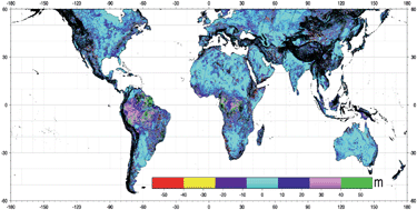
The new ACE2 (Altimeter Corrected Elevations 2) Global Digital Elevation Model (GDEM) which has recently been released aims to provide the most accurate GDEM to date. ACE2 was created by synergistically merging the SRTM and altimetry datasets. The comprehensive comparison carried out between the two datasets yielded a myriad of information, with the areas of disagreement providing as much valuable information as the areas of agreement. Analysis of the comparison dataset revealed that certain topographic features displayed consistent differences between the two datasets. The largest differences globally are present over the rainforests, particularly the two largest, around the Amazon and the Congo. The differences range between 10 m and 40 m; these differences can be attributed to the height of the rainforest canopy, as the SRTM returned height values from somewhere within the uppermost reaches of the vegetation whereas the altimeter was able to penetrate through and return true ground heights. The second major class of terrain feature to demonstrate coherent differences are desert regions; here, different deserts present different characteristics. The final area of interest is that of Wetlands; these are areas of special significance because even a slight misrepresentation of the heights can have wide ranging effects in modelling wetland areas. These examples illustrate the valuable additional information content gleaned from the synergistic global combination of the two datasets.
 Please wait while we load your content...