
Spatial–temporal analysis of various land use classifications and their long-term alteration's impact on hydrological components: using remote sensing, SAGA-GIS, and ARCSWAT model

Abstract
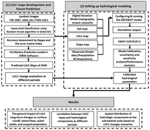
Future land use land cover (LULC) changes are significant concerns that substantially impact the water balance components of the watershed. LULC transformation may have negative consequences on soil erosion, disrupting the sustainability of water resources, and maintaining hydrological balance. Therefore, this study evaluates the potential impact of LULC changes in past and future scenarios on the hydrological components of the Chalus basin, Northern Iran. In this case, the LULC maps of 1987, 2001, and 2021 were classified by the random forest algorithm, and 2049's LULC was predicted using the CA–Markov model. The accuracy assessment of all the years was investigated utilizing confusion matrices, the kappa coefficients, and overall accuracies. Then, different LULC scenarios were applied to the calibrated Soil and Water Assessment Tool (SWAT) model to analyze the monthly and annual rates of evapotranspiration, surface runoff, lateral flow, and water yield. The result revealed that each land use scenario significantly impacts hydrological components. We found that with the reduction of forest and rangeland by expanding built-up and cultivated land, the average annual surface runoff, and water yield will increase by approximately +7.6%, and +3.3%, respectively, until 2049. The result was proved by a high negative correlation between built-up, cultivated land, forest, and rangeland. However, the average annual rate of lateral flow and evapotranspiration will decrease by roughly −3.2% and −1.09% up to 2049 in the middle and downstream of the study area. The declining trend of evapotranspiration rates through the wet and dry seasons in the past and future LULC indicates that forest land produces more evapotranspiration than agricultural land in this area. This agreement was confirmed by the maximum correlation coefficient of 1.00. This research finding could assist urban planners and decision-makers in re-examining and organizing new strategies for sustainable development and water resource management.
 Please wait while we load your content...

