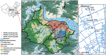
Identification of representative sampling sites is a critical issue in establishing an effective water quality monitoring program. This is especially important at the urban–agriculture interface where water quality conditions can change rapidly over short distances. The objective of this research was to optimize the spatial allocation of discrete monitoring sites for synoptic water quality monitoring through analysis of continuous longitudinal monitoring data collected by attaching a water quality sonde and GPS to a boat. Sampling was conducted six times from March to October 2009 along a 6.5 km segment of the Wen-Rui Tang River in eastern China that represented an urban–agricultural interface. When travelling at a velocity of ∼2.4 km h−1, this resulted in water quality measurements at ∼20 m interval. Ammonia nitrogen (NH4+–N), electrical conductivity (EC), dissolved oxygen (DO), and turbidity data were collected and analyzed using Cluster Analysis (CA) to identify optimal locations for establishment of long-term monitoring sites. The analysis identified two distinct water quality segments for NH4+–N and EC and three distinct segments for DO and turbidity. According to our research results, the current fixed-location sampling sites should be adjusted to more effectively capture the distinct differences in the spatial distribution of water quality conditions. In addition, this methodology identified river reaches that require more comprehensive study of the factors leading to the changes in water quality within the identified river segment. The study demonstrates that continuous longitudinal monitoring can be a highly effective method for optimizing monitoring site locations for water quality studies.
You have access to this article
 Please wait while we load your content...
Something went wrong. Try again?
Please wait while we load your content...
Something went wrong. Try again?